We found 109198 price guide item(s) matching your search
There are 109198 lots that match your search criteria. Subscribe now to get instant access to the full price guide service.
Click here to subscribe- List
- Grid
-
109198 item(s)/page


Lot 795
2 WWII British leaflets that were dropped on German troops, “Is it your turn now?” and “Bist Du an Der Reihe”, used in the Monte Cassino area; a 1944 War Office map of Paderborn Area; a British soldier’s passbook; 2 other books and Eisenhower’s message to the troops leaflet. QGC (some wear and tears)
Lot 466
A 1945 French Corps Expeditionnaire (Indo China) enamelled badge, map in shield on anchor, brooch pin; a WWII French “Jedburgh” team badge (adapted from British Parachute Regt WM cap badge); 8 WWI French cloth sidecap badges: 3rd, 150th Infantry (3 varieties), 25th, 61st, 156th and 163rd Art. GC -10


Lot 488
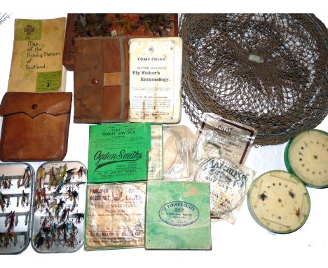
ACCESSORIES: (Qty) Alfred Ronalds Fly Fishers Entomology, 6th edition, canvas cover light foxing to front & rear pages, Wheatley alloy clip fly box 6" x4" holding various tradition steel eyed salmon flies, The Pull Out Patent pigskin cast wallet with contents, various casts in packets by Farlow, Pilot Tisdale new Zealand in Farlow and Ogden Smith boxes, box of old dapping flies, The BFSC linen foldout map of the Fishing Stations of Scotland, cast containers, early keep net etc.

Lot 603
Lumley & Dowell - "Norwegian Anglings" 1st ed 1907, paper covered H/b, some chips and grubby, fold out colour map to front, 238 pages, internally clean and Lumley & Dowell - "Norwegian Anglings" 1st ed 1914, loose on spine, chips to spine and edges, fold out map, interesting reading and great adverts. (2)


Lot 765
Norden & Speed - Essex divided into Hundreds, county map with inset town plan for Colchester and coats of arms for the Earls of Essex, later hand-coloured steel engraving, dated 1662, English text verso, 39 x 51cm Condition Report / Extra Information Framed. Small repair to edge of plate at upper right. Centrefolded. Possible tear at 6 o' clock. Paper not stuck down. Some light discolouration all over.


Lot 309
SHACKLETON E.H. Sir, Heart of the Atlantic, two vols, London 1909, 1st edition, cloth complete with 3 maps in pocket of vol.II (2) Condition Report / Extra Information Not ex-library. Spine cloth dull, small ½” tear to top of spine. Vil. 1 endpapers a bit browned, otherwise contents clean, sound and free of all inscriptions. All pages, photos and plates present, colour plates with tissue guards. Pocket at end of Vol. 2 contains maps of 'Route and Surveys of the Southern Journey Party' and 'Routes and Surveys of the Southern Magnetic Polar Party' - both clean and undamaged. The general map called for in the table of contents is not present, but a folding sheet with two panoramas (not called for) is present.


Lot 144
An early 19th Century silk needlework map depicting the counties in England and Wales, 50 cm x 46 cm CONDITION REPORTS Silk is all over yellowed/brown and dirty in appearance, some small rips and snags throughout, some areas where the weave is becoming loose, colours are faded particularly to flowers around border, frame is cracking and lifting in places, with some knocks and losses.


Lot 279
CASED COMPASS SET and attachments, all engraved MSW, cased Moore and Wright micrometer, a Waltham Admiralty Pattern #6 stop watch, an unusual cased pedometer with an Arabic numbered dial to 10 and a subsidiary dial to 100, a map distance measurer, converting centimetres to kilometres and 1/2 " to miles, three rulers, a scientific ruler, three magnifying glasses and a folding magnifying glass


Lot 221
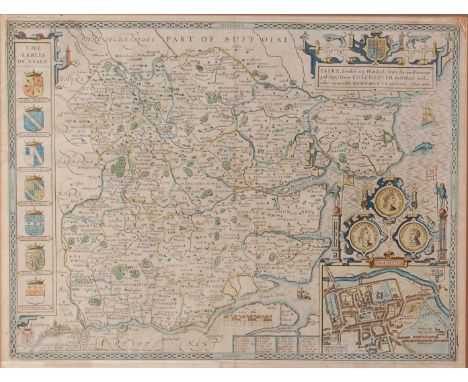
Robert Morden - Two antique hand coloured engraved maps - South Wales and The County Of Monmouth, 36cm x 42.5cm Condition: Although we are unable to tell if either map is 'laid down', there is some rippling and lifting across the surface which MAY suggest that it is not - ** General condition consistent with age


Lot 223
Matthieu Seutter - Antique hand coloured engraved map - La Plus Grand Partie de la Manche, qui contient Les Cotes D'Angleterre et celles de France, 49.5cm x 57cm Condition: Somewhat foxed which is more in evidence across the lighter areas, although we are unable to tell if this map is 'laid down' it does appear very flat which would suggest that it is - ** General condition consistent with age
Lot 642
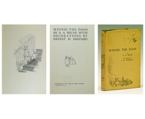
A.A. Milne - Winnie The Pooh, first edition, first impression, published by Methuen & Co Ltd 1926, original green cloth, titled to spine, pictorial decoration, top edge of pages gilt and with map endpapers, pictorial dust jacket with '117th Thousand' to back flap Condition: Please see extra images and TELEPHONE department for further details
Lot 59
DAVID GENTLEMAN (b.1930) Westminster College, lithograph in colours, pencil signed in the margin and numbered 32/175, 56 x 46cm; three monochrome prints after John Western, each with scene of Westminster School; an engraved view of the Hall of Christchurch, Oxford; three further engraved views of Christchurch and a reproduction map of the city and University of Oxford (9)


Lot 328
ARROWSMITH, Aaron - Map of England and Wales,: London 1815. Folding engraved map, hand-coloured in outline, 16 sheets only (of 18), divided into 120 smaller sections and backed onto 15 linen sheets, overall size 352 x 277cm), with one hand-coloured engraved key map, in fitted box. (missing sheets include sheet 3 (which bears the title) and sheet 1800).
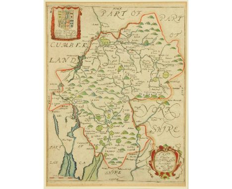
![BLAEU, Jan : [ Northamptonshire ] hand coloured map, 495 x 410 mm, in attractive modern gilt frame, not laid down, c1645.](https://cdn.globalauctionplatform.com/4622f90d-9ff5-49ee-9b7c-a44800e12af9/f9488367-25f4-4740-f228-ae11196a0c74/468x382.jpg)
-
109198 item(s)/page