We found 109198 price guide item(s) matching your search

Refine your search

Year

Filter by Price Range
  • List
  • Grid
  • 109198 item(s)
    /page

Lot 702

WW2 British Army Officers pre war private purchase map case with leather sling. Snap fasteners are marked "Derby" and "Made in Germany". Named to "Capt Thornhill 293003". Capt Thornhill served in the Far East as a map maker. Included in the case are several maps including one hand drawn map of enemy positions and a large captured Imperial Japanese map showing air routes. Also included is a large group photo of British and Indian troops.

Lot 751

WW2 Third Reich & British Maps including four large town maps of Berlin, Stuttgart, Essen -Manheim, Michelin Map of Germany 1944 printed on back of German military map, Vienna, Hamburg & Berlin, SE England, Europe, Breslau, Chatham & Maidstone. 14 maps in total. War souvenirs of a British Soldier who served with the Intel Platoon, Coldstream Guards, Guards Armoured Div in 1944-1945 in Belgium, Holland, Germany inc Berlin. 

Lot 114

Lodge Spark Plug in Tin, Tunbridge ware box, lighters, Wade Whimsies, rulers, Bacon's Map etc:- One Tray

Lot 1075

Printed silk WWII escape map scarf, sheet M & L French Indo China; sweetheart cards and souvenir embroidered handkerchiefs, printed cotton map of Europe, silk handkerchiefs of Allied flags, two CC41 cotton hankies and ration book, assorted 20th century handkerchiefs in silk, cotton and polyester, printed and embroidered, souvenir, royalty, nursery, mourning etc and album of clear plastic postcard pages, album containing stamps etc

Lot 1148

A Dance (20th century), The jetty, signed oil on canvas, 39cm by 50cm, and a quantity of pictures and prints, to include: a watercolour signed George Skelton, an antique map of Derbyshire, a map of the British Virgin Islands (qty)

Lot 1134

After John Speede, A map of Rutlandshire, with Oaken and Stamford, 41cm by 53.5cm

Lot 1145

John Speede map of Durham; together with with three other maps and various travel prints

Lot 2442

A world war 2 map magnifying glass and a small brass & copper miner's lamp.

Lot 594

Thomas Kitchin. An 18th century New and Accurate Map of Warwickshire. Framed. 27' x 21'

Lot 131

Strabo. De situ orbis libri XVII, collation: α4 AA-BB a-z A-Z aA-vV6 xX4, complete with blank leaf α4 and final leaf blank except for printer's woodcut device on verso, woodcut initials, small map on vV1 verso, double column Greek and Latin text, some browning, mostly light, some early ink annotations, small leather book-label of Haven O'More, contemporary blind-stamped pigskin over wooden boards, metal clasps intact, folio (310 x 204mm.), Basel, Henricus Petrus, 1549.⁂ A very impressive copy in a stunning contemporary binding of Strabo's geography, the only extant work covering the whole world known at the beginning of the Common Era.Literature: Adams S1905Provenance: contemporary ink inscription dated 1566 smudged so largely illegible.

Lot 173

Wallace (Alfred Russell) Darwinism: An Exposition of the Theory of Natural Selection, first edition, half-title, portrait frontispiece, folding map, illustrations and diagrams, armorial bookplate dated 1886 and smal leather book-label of Haven O'More, contemporary green half morocco over marbled boards by C.Cross ('binder to the Queen'), t.e.g., 8vo, 1889.

Lot 233

Canals.- Whitworth (Richard) The Advantages of Inland Navigation...to shew that an Inland Navigation may be easily effected between the three great Ports of Bristol, Liverpool, and Hull, first edition, presentation copy from the author to John Turton with Turton's ink inscription at head of title (and others to front free endpaper), folding engraved portrait of the Duke of Bridgewater, 4 folding tables of furnaces & forges, manufactures & merchandizes, expenses, & landowners, large folding engraved map with routes supplied in red or green, browned and soiled, slight worming to map, bookplate of John Turton of the Inner Temple, contemporary calf, rubbed, rebacked preserving old morocco label, corners repaired, worming to lower corners and edges, 8vo, for R.Baldwin, 1766.⁂ Rare work by the High Sheriff of Staffordshire 1758/9 and MP for Stafford from 1768 to 1780.

Lot 266

Winlove (Solomon) A Collection of the Most Approved Entertaining Stories, new edition, engraved frontispiece and 5 plates, woodcut illustrations, 3pp. advertisements, lacking rear endpaper, ink name to head of title and pastedown, original floral boards, loss to spine, rubbed, [Roscoe J381(6)], F. Newbery, [c.1795] § [Kilner (Dorothy)] The Life and Perambulation of a Mouse, 2 vol. in 1, frontispiece to vol. 1 only, engraved titles, woodcut illustrations, closely trimmed at head, affecting vol. 2 headlines, contemporary calf-backed boards, rubbed, [Osborne p.273], John Marshall, [c.1790] § [Longueville (Peter)] The English Hermit, or the Adventures of Philip Quarll, wood-engraved frontispiece, map, and 20 illustrations, 6 pages advertisements at end, original boards with paper label to upper cover, spine worn with loss, Baldwin, Cradock, and Joy, 1816; and 5 others, Newbery and Marshall, 12mo (8)⁂ All scarce, the first including popular fairy stories Jack Horner, Cinderella and Little Red Riding Hood.

Lot 268

Game.- Darton (W. & T., publisher) Walker's Tour through England and Wales, a New Pastime, hand-coloured engraved map with columns of letterpress directions to either side, dissected and mounted on linen, c.530 x 650mm., excellent bright colouring, folding into original speckled board slip-case with printed orange title to upper cover and publisher's label to lower, rubbed, wear to corners, [Whiteouse p.13], 8vo, W. & T.Darton, 1809 [water-marked 1819].

Lot 271

Game.- Jefferys (Thomas) The Royal Geographical Pastime; exhibiting a Complete Tour Round the World, in which are delineated the North East and North West Passages into the South Sea..., hand-coloured engraved map with columns of letterpress explanation and directions to either side, dissected and mounted on linen, c.510 x 710mm., a little soiled (mostly light but heavier to edge of some sheets from folding), folding into original marbled board slip-case with engraved label to upper cover, rubbed, worn at lower edge, [Not in Whitehouse], 8vo, Thomas Jefferys, [Printed & Sold by Wm.Faden], 1770.⁂ Very rare early board game with 103 numbered locations, each of which is briefly described in the letterpress sections with an occasional instruction to the "traveller" to stay a turn to see or experience the sights. At no.58, the North-West passage, "the traveller, who has been so fortunate to find his way through this Passage, shall be removed to Cape Horn, No.79". At no. 60 California "the inhabitants having no houses, dwell in arbours in summer, and creep into caves in the winter". Library Hub and WorldCat list one copy only (British Library). The earliest game with a tour of the world listed by Whitehouse is Wallis's 'New Geographical Pastime' of 1796.

Lot 273

Game.- Wallis (John, publisher) Wallis's Tour of Europe. A New Geographical Pastime, hand-coloured engraved sheet, dissected and mounted on linen, c.480 x 510mm., soiled, some spotting, with the booklet of rules, foxed, original wrappers, rubbed and stained, together in original board slip-case with hand-coloured engraved pictorial label mounted on upper cover, rather worn and stained, John Wallis, 1811 § Darton (W. & T., publisher) Walker's Tour through England and Wales, a New Pastime, hand-coloured engraved map with columns of letterpress directions to either side, dissected and mounted on linen, c.540 x 655mm., a little spotted and browned, folding into original speckled board slip-case with printed yellow title to upper cover and publisher's label to lower, a little worn and chipped, W. & T.Darton, 1809, [Whitehouse p.9 & 13], 8vo (2)

Lot 275

Game.- Wallis (Edward, publisher) Game of the Star-Spangled Banner, or Emigrants to the United States, hand-coloured engraved aquatint pictorial map of central and eastern United States, dissected and mounted on linen, c.670 x 500mm., a little soiled and lightly spotted, folding into original gilt-pictorial cloth folder, a little rubbed, stained, lacking ties, [Whitehouse p.44], small 4to, E.Wallis, [c.1842].⁂ Rare game depicting the geography, inhabitants, fauna & flora, buildings and scenes of the eastern half of the United States, which Whitehouse illustrates as his frontispiece. Library Hub lists only one copy in the UK (BL); WorldCat records that and another at Yale.

Lot 285

Birds.- Sclater (Philip Lutley) A Monograph of the Birds forming the Tanagrine Genus Calliste, first edition, 45 hand-coloured lithographed plates after P.L.Oudart, heightened with gum arabic, partly-coloured engraved map, [Anker 448; Fine Bird Books p.139; Nissen IVB 839], a very good copy, 1857; Synopsis of the Fissirostral Family Bucconidae, reprinted, with additions, from 'Annals and Magazine of Natural History' 2nd Series 1854, 4 hand-coloured lithographed plates after P.L.Oudart, lightly offset, [Not in Nissen], 1854, together 2 works in 1 vol., S.Dillon Ripley's copy with his bookplate, contemporary half red morocco, t.e.g., others uncut, spine gilt, slightly rubbed, 8vo.⁂ S.Dillon Ripley (1913-2001), American ornithologist and conservationist who served as Secretary of the Smithsonian Institution from 1964 to 1984.

Lot 287

Birds.- Sharpe (Richard Bowdler) A Monograph of the Alcedinidae: or, Family of Kingfishers, bound from the original 15 parts, first edition, list of subscribers, hand-coloured lithographed 'Map of the Family Alcedinidae', uncoloured lithographed plate of characteristics and 120 hand-coloured lithographed plates after J.G.Keulemans printed and coloured by P.W.M.Trap, many heightened with gum arabic, with original printed pink wrappers bound in at end, also cancel sheet for 'Strickland's Kingfisher' erroneously headed 'Ceyx Tridactyla' and erratum slip with instructions re cancellation (plate in text with correct caption pasted over), some light spotting, some plates a little smaller but part wrappers also varying in size, as a result some margins lightly soiled/browned and brittle or frayed at edges, bookplate of Edward Milner, later half pigskin, uncut, rubbed, upper joint a little worn, recased, new endpapers, [Anker 464; Fine Bird Books p.141; Nissen IVB 864], 4to, for the Author, 1868-71.⁂ The author's first ornithological work. The list of subscribers includes most of the great ornithological authors of the time: H.E.Dresser, D.G.Elliott, John Gould, J.E.Harting, Sir William Jardine, Lord Lilford, G.F.L.Marshall, O.Salvin, P.L.Sclater, Capt. Shelley.

Lot 300

Africa.- Bosman (William) A New and Accurate Description of the Coast of Guinea, Divided into the Gold, the Slave, and the Ivory Coasts, second English edition, folding engraved map, 7 engraved plates, lacks 3pp. advertisements at end, bookplate of George Vaughan Hart, contemporary panelled calf, spine gilt with old paper label to foot, rubbed and a little worn in patches, spine worn at head, joints split, J.Knapton, D.Midwinter, B.Lintot, G.Strahan, J.Round, and E.Bell, 1721 § Moore (Francis) Travels into the Inland Parts of Africa, first edition, folding engraved map and 10 engraved plates only (of 11), one folding, map and folding plate with tears to folds, plate frayed at foot, a little foxed and soiled, engraved bookplate of Joseph Harford, contemporary sprinkled calf, rubbed, upper joint split, corners and spine ends worn, by Edward Cave, for the author, 1738, 8vo (2)

Lot 307

Americas.- Emigration.- [Burlend (Rebecca)] A True Picture of Emigration: or Fourteen Years in the Interior of North America..., first edition, bookplate of Edward M.Shepard of Erlowest, Lake George on inside front wrapper, original lilac printed wrappers, slightly soiled, faded at edges, [Sabin 97133], London & Leeds, G.Berger, [1848] § Watts (Samuel) Facts for the Information of Intending Emigrants, about the Province of New Brunswick, first edition, folding lithographed map, contemporary ink initials "G.R.G." at head of title, original pink printed wrappers, advertisement for Anchor Line steamships to lower wrapper, spine slightly faded, [Not in Sabin], Woodstock, 1870, 8vo (2)⁂ The first is an account of a Yorkshire English family's experience settling in Pike County, Illinois; the second is not recorded by Library Hub but WorldCat lists 3 UK copies (BL, Cambridge and King's College London), plus 2 in America and 2 in Spain.

Lot 310

Americas.- Henry (Alexander) Travels and Adventures in Canada and the Indian Territories, between the years 1760 and 1776, first edition, errata leaf at end, lightly soiled, small tear to upper margin of p.105, contemporary calf-backed blue paste-paper boards, spine gilt, rubbed, spine worn at head, [Sabin 31383], New York, 1809 § Gray (Hugh) [Letters from] Canada...exhibiting also the commercial importance of Nova-Scotia, New Brunswick, & Cape Breton, first edition, folding engraved map with routes supplied by hand in red and yellow, 3 folding tables, portion cut away from head of title with loss of "Letters from", foxed, engraved bookplate of Genl. Hon.ble Robert Taylor with his note in pencil "Presented to me by my dear friend the Countess of Ormonde wife to Walter Earl & afterwards Marquess R.T." to front free endpaper, contemporary diced russia with elaborate gilt border, spine gilt in compartments, joints neatly repaired, [Sabin 28393; Goldsmiths' 19842; Kress B.5510], 1809, 8vo (2)⁂ The first is a detailed account of the Canadian fur trade by a British trader who spent some time in captivity with the natives following the massacre at Detroit during Pontiac's War. The second covers the trade, political relations, laws, customs and climate of Canada.

Lot 312

Americas.- Neal (Daniel) The History of New-England..., 2 vol., first edition, titles in red and black, folding engraved map, some spotting and browning, vol.2 with slight worming to lower margin, contemporary panelled calf (not quite uniform), rubbed, vol.2 rebacked and corners repaired, both with later matching gilt spines, [Sabin 52140], 8vo, for J.Clark...R.Ford...and R.Cruttenden, 1720.

Lot 313

Americas.- South America.- La Condamine (Charles-Marie de) A Succinct Abridgement of a Voyage Made within the Inland Parts of South-America, first English edition, half-title, folding engraved map, small tear to fold repaired, faint contemporary ink signature to title, lightly browned, contemporary tree calf, gilt, spine gilt with red morocco label, a little rubbed, splits to joints, spine ends chipped, [Sabin 38488], 8vo, for E.Withers...and G.Woodfall, 1747.⁂ The first scientific exploration of the River Amazon.

Lot 317

Americas.- [?Wein (Paul)] A Concise Historical Account of all the British Colonies in North-America, first Dublin edition, folding engraved map of "100 Miles round Boston", folding table of details of the colonies (short tear at inner edge), one or two small stains, bookplate partly erased, attractive contemporary mottled calf, red roan label (chipped), rubbed, small patch repaired on lower board, [Sabin 15116], 12mo, Dublin, for Caleb Jenkin...and John Beatty, 1776.⁂ First published in London the previous year ESTC records only one UK copy of this Dublin edition (University of Ulster at Magee College Library, Londonderry).

Lot 319

Australia.- Hunter (John) An Historical Journal of the Transactions at Port Jackson and Norfolk Island...With an Abridged Account of the New Discoveries in the South Seas, stipple-engraved portrait after R.Dighton, engraved vignette title, folding engraved map and folding plate of New South Wales family engraved by William Blake after King, with 3pp. advertisements at end, foxing to portrait and title, some other light spotting, map with short tear to inner edge, original boards, uncut, spine titled in manuscript, rubbed and soiled, spine browned and with short tear at foot, [Ferguson 153; Wantrup 14a], 8vo, John Stockdale, 1793.⁂ John Hunter served under Arthur Phillip in the first convict fleet and succeeded him as the second Governor of the colony from 1795 to 1799.

Lot 326

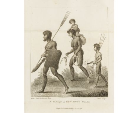
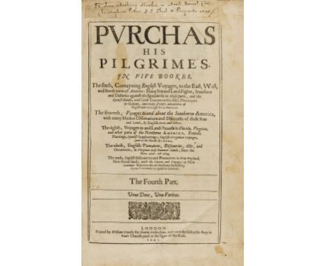
World.- Purchas (Samuel) Purchas his Pilgrimes. In Five Books..., 5 vol. including vol.5: Purchas His Pilgrimage, first edition of vol.1-4, vol.5 fourth edition, second issue, lacking additional engraved title (as often, supplied in old photographic facsimile), with 7 folding and/or double-page engraved maps of the Mogul Empire, China (duplicated in vol.5), Greenland (Spitsbergen), North America, New England and Virginia (the latter in Verner's state 7 of 12) , 81 half-page engraved maps after Hondius (58 in vol.1-4 and 23 in vol.5, the latter duplications of maps in vol.1-4), a few other engraved or woodcut illustrations including Aztec pictograms from the Codex Mendoza in vol.3, vol.1 with Hondius's 'Map of the Christian World' appearing twice at pp. 65 and 115 i.e. lacking 'Map of the Whole World', and with G3-4 uncancelled as usual, also 4M4-5 uncancelled and second state of 4M2, severe paper flaw to 3M6 in vol.1 with loss to 5 lines of text and side-notes, vol.4 with map of Virginia torn and creased (repaired) and final 2 leaves slightly defective at fore-edge with loss to edge of 'Map of Great Brittaine and Ireland', occasional soiling or browning, a few stains, some other minor tears and defects, some repaired, near uniform contemporary calf ruled in blind, rubbed, vol.1-4 lacking ties and with holes from ties and hasps for chains, rebacked, new pink morocco labels, endpapers replaced, [Hill 1402-3; Sabin 66682 & 66686; STC 20508-9], folio, by William Stansby for Henrie Fetherstone, 1625-26. ⁂ An excellent tall set of this important collection of voyages, a continuation of Hakluyt's Principal Navigations, with fine impressions of the maps and in a contemporary (once chained) binding with a distinguished provenance. The map of the Mogul Empire by William Baffin is the earliest English map of the Mogul territories; the map of China is based on a Chinese original and one of the earliest such to be published in Europe; the map of Greenland (actually Spitsbergen) incorporates scenes of whaling and bear-hunting; the map of North America, by Elstracke after Henry Biggs, is the first to show California as an island; the map of New England was first published in 1624; the map of Virginia by William Hole after Capt. John Smith is one of the most important early maps of America and includes a large Indian figure and a vignette depicting the interior of Powhatan's hut.Provenance: vol.1-4 from the ancient chained library of Queen's College, Oxford, presented by Anthony Hawles. With contemporary ink manuscript presentation label pasted to head of titles of vol.2-4: "Ex dono Anthony Hawles in Artib. Com.m / Christophero Potter S.S Theol. D. Praeposito. 1629" (partly removed from vol.2 & 3), and engraved Queen's College bookplates to verso of titles of vol.1-4. The library contains a second set, the present set was probably sold as a duplicate with other works in 1938.A detailed collation and list of faults is available on request.Anthony Hawles (1609-1663), was chaplain to Charles II while in exile, Archdeacon of Salisbury 1657-63 and a canon of Windsor from 1660 until his death. Christopher Potter (1591-1646) was elected Provost of Queen's College in 1626. He was a chaplain to Charles I, a canon of Windsor and appointed Dean of Worcester in 1635, before being arrested in 1642 and having his Worcestershire properties sequestered.

Lot 329

Jerusalem.- Prado (Jeronimo de) and Juan Bautista Villapando. In Ezechielem Explanationes et Apparatus Urbis, ac Templi Hierosolymitani Commentariis et Imaginibus Illustratus, 3 vol., first edition, 3 engraved titles, portrait and 31 plates/vignettes only (of 32, lacking folding plate in vol.1 between pp.13 and 17), most folding or double-page, 8 folding tables (one printed in red and black), woodcut map and other small woodcut illustrations and diagrams in text, a few plates with repairs, some foxing and light staining but generally a sound copy, later vellum, red and green morocco spine labels lettered in gilt, extremities a little worn, folio, Rome, 1596-1605.⁂ A very good copy of this monumental work on the Temple of Solomon in Jerusalem.Provenance: St. Hugh's Parkminster (small ink stamp to titles).

Lot 425

García Márquez (Gabriel) El General en su Laberinto. Novela, number 118 of 1,000 copies signed by the author, map endpapers, original cloth, fine, unopened and uncut, original slip-case with labels to upper and lower covers, 8vo, Madrid, 1989.

Lot 427

Grahame (Kenneth) The Wind in the Willows, number 177 of 250 copies signed by the artist, colour illustrations and map endpapers by E.H. Shepard, original full green morocco, gilt, spine slightly faded, g.e., publisher's slip-case, an excellent copy, 8vo, 1971.

Lot 533

Armenia.- Lynch (H. F. B.) Armenia: Travels and Studies, 2 vol., first edition, frontispieces, 1 folding with lower corner cut away, plates and illustrations, maps, most folding or double-page, large folding map in pocket at end vol. 1, marginal worming (vol. 2), occasional faint spotting, modern cloth, 8vo, 1901.

Lot 538

India.- Burgess (James) On the Muhammadan Architecture of Bharoch, Cambay, Dholka, Champanir, and Mahmudabad in Gujarat, 77 plates & plans, some collotype, 4 double-page, 6pp. advertisements at end, 1896 § Burgess (James) & Henry Cousens. The Architectural Antiquities of Northern Gujarat, more especially of the Districts included in the Baroda state, colour map and 111 plates and plans, some collotype, one double-page, 4pp. advertisements at end, light foxing to first few leaves, 1903, Archaeological Survey of Western India vol.VI & IX, uniform original cloth, both a little rubbed, the second soiled & stained and rebacked preserving original spine, new endpapers, 4to (2)

Lot 543

India.- Fergusson (James) Illustrations of various styles of Indian Architecture. A Series of Fifteen Photographs of some of the most important buildings in India erected between B.C. 250 and A.D. 1830. With a Lecture on the Study of Indian Architecture..., 2 parts in 1, first edition, 1 mounted albumen print and 14 mounted permanent prints (proto-Woodburytypes) printed by the Photo-Relief Printing Co. (mostly c.140 x 100mm or vice versa), map, wood-engraved illustrations, small ink stamp at head of title, some light soiling, modern morocco-backed boards, part of original binding with title mounted on upper cover, slightly rubbed, 8vo, 1869.⁂ One of the author's scarcest works, illustrated with photographs of major monuments by Lt. Waterhouse, Mr. Burke, Samuel Bourne, Dr. Neill, Col. Biggs and others.

Lot 552

South East Asia.- Crawfurd (John) Journal of an Embassy from the Governor-General of India to the Courts of Siam and Cochin China; exhibiting a view of the Actual State of Those Kingdoms, first edition, folding aquatint frontispiece, large folding engraved map (neatly backed with repairs to margins and at folds), 9 aquatint plates, 2 engraved plans and 2 engraved plates of alphabets, folding table of vocabularies at end, occasional spotting, contemporary boards, neatly and sympathetically rebacked in buckram, printed paper label to spine, [Abbey, Travel 405], 4to, 1828.⁂ Scarce account of a diplomatic voyage through Thailand, Vietnam, and the Malay Peninsula. The plans are of Singapore and Bangkok.

Lot 401

VINTAGE FRAMED MAP OF BLYTH HARBOUR

Lot 754

MAP London Comprehending the New Buildings and Other Alterations to the Year 1792 hand cold. on linen with original case

Lot 775

MAPS c.20 maps incl. St. Petersberg 1896, Oxford 1817, military map N. Libya

Lot 249

Small Selection of Various British Personal Itemsincluding Defence overprint map of Wesel dated 1944 ... Spare ammunition bandolier dated 1943 ... 1940 dated tubular whistle ... Horlicks tablet tin ... Boxed ear defender ... Housewife ... 2 x British ID tags ... Small selection of shrapnel. Quantity.

Lot 250

Small Selection of Various WW1 and WW2 British Personal Itemsincluding linen backed map of Amiens dated 1918 ... Paper map of Lens dated 1918 ... Bournville cocoa tin ... Tea and sugar box ... Cast alloy Victory bell, unfinished .... Brass, rifle oil bottle ... Brass button stick ... Revolver lanyard ... KC white metal ARP lapel badge.

Lot 402

Quantity of East German Equipmentincluding 2 x leather map cases ... 3 x splinter pattern pouches ... 2 x camo waterbottles ... 2 x respirators in cases. Quantity.

Lot 492

Air Ministry Silk Escape Map of Germanyblack and white, single sided, printed map covering Germany and part of the Border countries. Code stamped “9U” with “ADL (Maps) Air Ministry No 7330”. Folded with minor stains.

Lot 400

John Speed (1552-1629), 'Somersetshire', engraved county map, sold by Thomas Bassett in Fleet Street and Richard Chiswell in St Paul's Churchyard, English text verso, 41x54cm

Lot 87

Tony King (American, b.1944) Title: Yellow Gray Map Pop Art Oil on Canvas Signed, Verso with title and date Canvas: 72 in. x 84 in. Condition: Good overall condition with edge wear and loss, staining to lower border. For inquiries, condition report and additional images please email info.hillgallery@gmail.com Provenance: Property of a Hollywood socialite. Shipping: Hill Auction Gallery will not ship. Gallery will refer professional third party shippers for USA Domestic and International buyers. Purchaser pick up available upon request.

Lot 591

A large map of St Ives to Dodman Point

Lot 209

Navel Map reader- Scales up as the inch for measuring miles + verstes -Made in Switzerland in original Box

Lot 386

The Wonder book of Motors The Romance of the Road editor Harry Golding published Ward Lock & Co Ltd; 256 pp 12 colour plates 200 + illustrations VG-Goldsmith Oliver A History of the Earth and Animated Nature Vol. I published London 1868 Blackie and Son hardback; some illustrations water stains and some foxing fair-Smith Sidney Forensic Medicine published J & A Churchill 1931 third edition 631pp 170 illustrations; covers death by violence, poison etc some wear but fine-Kelly's Directory of Norfolk 1933 with coloured map some foxing fair

Lot 62

A novelty soapstone chess and solitare set, shape as a map of Africa; a chinese tea for two in a wicker basket; a barometer/hygrometer; three Coalport figures of fashion; Minton; Staffordshire ceramics; a frosted glass table lamp; etc

Lot 301

Rob Morden -a map of West Riding of Yorkshire sold by Abel Swale Aronsham & John Churchill, together with an oil on board of a lake scene, signed Marjorie Bickerton

Lot 442

An engraved cattle horn powder flask, depicting a map of the Hudson River, wooden top and large sprung shutter; a copper flask embossed with a trophy of arms; two pistol size flasks, one leather clad and the other embossed with the American Eagle; and a .36 calibre two cavity bullet mould, to throw conical and spherical bullets. [5]

Lot 285

A good Derby figure of a map seller, circa 1770With a partially unfurled map held in his right hand painted in colours with a land mass, an area to the southeast inscribed 'Terra incog.', another rolled map under his left arm, carrying a large backpack, his costume brightly coloured, standing on a scrolled base, 15cm high, patch marks

Lot 339

LARGE MAP OF CHINA (around 5ft square)

Lot 221

MEXICAN INTERNATIONAL RAILROAD FOLDING MAP & TIMETABLE 1892, American Bank Note Company, New York

Lot 4

A FRAMED AND GLAZED ENGRAVING OF WHITBY BY FRANK H. MASON TOGETHER WITH AN ORIGINAL FRAMED AND GLAZED JOHN CARY MAP OF WARWICKSHIRE TOGETHER WITH A WATERCOLOUR OF A COASTAL SCENE SIGNED LOWER RIGHT (3)

Lot 469

TWO BOXES OF BOOKS TO INCLUDE HISTORY INTEREST, ANTIQUE MAP REFERENCE BOOKS ETC.

Lot 332

MAP OF THE ROMAN EMPIRE by Robert de Vaugondy c.1810. 490mm x 660mm, hand coloured in outline. Framed and glazed.

Lot 41

Two pine boxes containing 93 8cm x 8cm glass slides, 19th century, various themes including, map of the Chinese empire, Canton street scene, theatre at Tien Tsin, Great Wall, Temple of Heaven Pekin, Western Gate Pekin, Chinese Punchinello, Chinese shuttlecock and some European themes, including Queen Victoria, some slides made up from book plates (2)

Lot 56

A pair of 9ct gold 'Advance Australia' map cufflinks, each modelled as the outline of Australia, with Kangaroo and Ostrich, marked 9ct, 5g.

Lot 570

After Robert Morden. Map of Lincolnshire, later coloured, 40cm x 47cm.

Lot 193

John Ogilby, original coloured road map from London to Hith, together with new map of South Wales engraved for Walpoole's and a reproduction coloured map of Kent. All framed and glazed. (B.P. 24% incl. VAT)

Lot 198

Christopher Saxton, coloured map of Pembrockshire, framed and glazed. (B.P. 24% incl. VAT)

Loading...Loading...
  • 109198 item(s)
    /page

Recently Viewed Lots