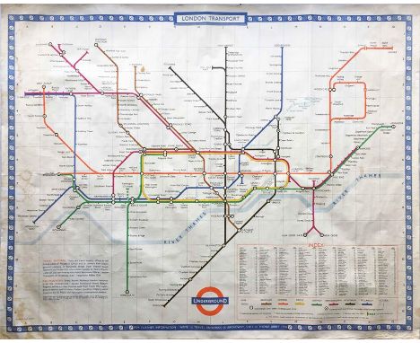
We found 109182 price guide item(s) matching your search

Refine your search

Year

Filter by Price Range
  • List
  • Grid
  • 109182 item(s)
    /page

Lot 139

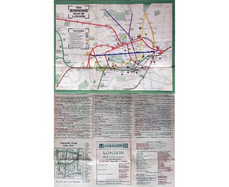
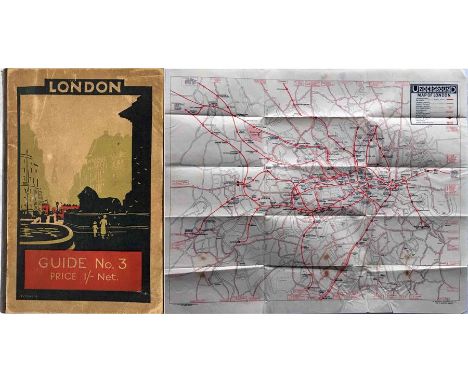
1924 London Underground GUIDEBOOK 'London Guide No 3' containing a separate (enclosed in a fixed envelope) UNDERGROUND MAP believed to have been unique to these guides. Printed on thin paper and opening out to 17.5" x 14" (45cm x 36cm), the map is single-coloured and shows the British Empire Exhibition and the Charing Cross link and Morden extensions as under construction. In good, used condition, small stains on the map. [1]

Lot 144

Pair of Metropolitan Railway POCKET MAPS of London (the Met's version of the Underground map) comprising the issue with pale blue cover coded M805/100M (c1926-7) and the issue with green cover coded M.1495/100M (c1931, Stanmore branch under construction). Both are in used condition with some fold tears. [2]

Lot 15

1911 London Underground POCKET MAP printed by Johnson, Riddle & Co Ltd. This edition shows the 3 separate Hammersmith stations, the CLR extension to Liverpool St under construction and the LBSCR lines to Crystal Palace. Ex-guidebook example with the usual small cut-out at the margin and subsequently re-folded. Opens out to 10.5" x 8" (27cm x 20cm). In good, lightly-used condition. [1]

Lot 154

1924/5 London Underground MAP of the Electric Railways of London "What to see and how to travel". Winter 1924/25 (November 1924) edition. In very good condition, just a couple of small corner-partings. [1]

Lot 155

1934 London Transport BOOKLET 'Pleasure Parties, School Outings' with attractive covers illustrated by Arnrid Johnston (1895-1972), female artist, born in Sweden, who designed for LT from 1930-35. Small rubber stamp on cover, otherwise very good. Plus a c1915-1920 Port of London Authority BOOKLET WITH FOLD-OUT MAP 'Souvenir of an Excursion on the River Thames from London to Teddington'. Picture shows only part of the map. Foxing stains to cover, contents very good. [2]

Lot 166

The "District" [Railway] MAP of Greater London & Environs, 2nd edition, undated but c1908 (shows Franco-British Exhibition). A large-scale, full-colour map (42" x 26", 107cm x 66cm), linen-backed and folded into hard covers. Bakerloo, Hampstead & Piccadilly tubes shown in bold, non-Group tubes, eg Central and C&SLR, not highlighted! Map is in good condition, covers worn and partly detached, original owner's name on cover. [1]

Lot 168

A MAP of the 'Amersham & District [bus] Routes as at 24.11.33' produced by F H Stingemore and initialled and dated by him 18.6.35. Shows the numbered and coloured routes superimposed on an OS 1" Watford area map. Very neatly and expertly produced, as would be expected of Mr Stingemore. Map is on stiff paper, opens out to 32.5" x 24" (82cm x 63cm) and is in generally very good condition. [1]

Lot 171

1934 London Underground 'Railways of London' POCKET MAP. An early H C Beck diagrammatic card map with print reference 34-1945 350M and showing the escalator connection between Bank and Monument stations. In excellent, unmarked condition, crisp & firm. [1]

Lot 181

Selection of pre-WW2 London Transport GREEN LINE COACH GUIDE booklets comprising issues No 1, 1936, No 2, 1936, Number 1, 1937 and Number 2, 1938. All bar the second retain the fold-out map. All in used condition but generally good. [4]

Lot 186

1977 London Underground quad-royal POSTER MAP designed by Paul Garbutt. Now shows BR's North London line as well as the first section of the 'Fleet' Line (today's Jubilee Line) under construction. The Piccadilly Line extension to Heathrow Central shown as opening 'late 1977'. A little darkening from U/V exposure towards the right-hand edge, otherwise generally very good. [1]

Lot 187

1930s Eastern National double-crown (20" x 30" - 51cm x 36cm) POSTER 'London East Coast Express Services' with a map of the routes and an illustration of a single-decker coach by a rural church with a 'yokel' looking on. Has previously been folded, some small stains and edge-nicks but generally still good. [1]

Lot 192

Special edition, c1965, of the London Underground POCKET DIAGRAMMATIC MAP, a paper version produced for distribution to arriving passengers at the British European Airways (BEA) West London Air Terminal in Cromwell Road with walking directions to Gloucester Road station. A most unusual item. In excellent condition. [1]

Lot 193

Special edition of the 1966 London Underground POCKET DIAGRAMMATIC MAP, a paper version produced for the World Cup with 'World Cup Willie' on the cover and how to get to Wembley and White City Stadia on the reverse. A few pin holes and minor ageing but generally good. [1]

Lot 198

1923 London Underground MAP of the Electric Railways of London "What to see and how to travel". Designed by MacDonald Gill with his distinctive style of calligraphy and map border, this is the issue dated 1/1/23 and the version thereof which shows the British Empire Exhibition stations with red dots. Generally a very good copy, light staining on the front cover and a few foxing spots on the rear cover. [1]

Lot 200

1932 London Underground linen-card POCKET MAP from the Stingemore-designed series of 1925-32. This is the last issue (the final pre-Beck Underground map) with mustard cover and showing all the line extensions completed with opening dates on the reverse. A faint pencilled date on the cover but otherwise in very good condition. [1]

Lot 210

c1906 Great Western Railway (GWR) quad royal POSTER MAP of London tube lines showing the GWR route from Reading into Paddington and highlighting the Central London, Great Northern & City and City & South London tube lines, the latter's extension to King's Cross & Euston under construction. An amazing and most unusual survivor. Fragile at the folds, small losses, needs conservation. [1]

Lot 214

c1931/32 London Underground quad-royal POSTER MAP 'Underground Map of London'. Undated but a box at the top edge refers to the Southgate extension of the Piccadilly Railway as under construction. Folded,a little wear at some folds with a few small partings but generally a very reasonable example. [1]

Lot 217

1939 London Underground POSTER MAP by H C Beck. Shows the planned extensions of the Central Line to Epping and Denham, the Bakerloo Line to Stanmore and the Northern Line to Alexandra Palace, High Barnet and Bushey Heath. Beck has thickened the lines to allow the line names to be included within them. The map has been framed and measures 32" x 26" (81cm x 61cm) including the frame. Some creasing and a short horizontal tear about midway are evident, otherwise good. [1]

Lot 220

1962 London Underground POSTER MAP designed by Harold F Hutchinson in the short-lived style that did away with all curves. Shows the system in its post-war settled form, possibly the last map not to show the planned Victoria Line. An unusual, small-format poster measuring 19.5" x 15" (50cm x 33cm). A small tear at the l/h edge, otherwise in very good condition (folded). [1]

Lot 246

Selection of railway EPHEMERA including 1940s/50s ABC and BR Holiday GUIDES, EXCURSION LEAFLETS, CARRIAGE MAPS, one framed (some reprints), Daily Telegraph Underground, Rail & Tramways MAP OF LONDON, London's Country GUIDE No 1, 1940s Southern Railway cross-channel FOLDER W/TICKETS (Golden Arrow etc), 1977 Silver Jubilee BR MENU FOLDER, other maps etc. Lightly to well-used. [21 items]

Lot 248

c1908 postcard-size CARD MAP of the London Underground produced by G W Bacon & Co Ltd for the William Owen store in Westbourne Grove. Lines shown in colours against a streetmap background, the Central is actually depicted in today's red! Undated but shows 1908 Franco-British Exhibition. A most unusual item. Small punch holes at top edge, otherwise in excellent condition. [1]

Lot 260

1928 London Underground MAP of the Electric Railways of London "What to see and how to travel". Summer 1928 edition, designed by E G Perman with elaborate calligraphy of station names and border etc. In very good, lightly-used condition, just some foxing spots on the rear cover. [1]

Lot 271

1924 British Empire Exhibition at Wembley official fold-out PLAN & MAP designed by Kennedy North in a style similar to MacDonald Gill with an Underground map with calligraphed station names and elaborate, colourful illustrations. Lightly used with some cover wear but generally in good condition. [1]

Lot 272

c1924 Metropolitan Railway MAP "of Extension Lines into Metro-Land" backed with a map of central London showing the District and tube railways. Shows the British Empire Exhibition site at Wembley as well as the various new residential estates along the railway. Opens out to 19" x 15" (48cm x 38cm). A short tear at one edge, otherwise in very good condition. [1]

Lot 274

Metropolitan Railway items comprising 1905 'Country Walks' GUIDEBOOK 'The Harrow & Uxbridge Railway...is now open' (incl fold-out map of the Met Rlwy Extension), c1929 Met & LNER 'Country Walks' GUIDEBOOK No 3 and 1927 hard-cover BOOKLET 'Record of Events from the Opening of the Line in 1863, revised to 1927". Plus 1928 Metropolitan District Rlwy BOOKLET 'Diamond Jubilee, Exhibition of Rolling Stock...South Kensington Station". Condition varies from well-used to excellent. [4]

Lot 275

1909 Metropolitan & Great Central Joint Railway GUIDEBOOK 'Illustrated Guide.....Middlesex, Hertfordshire & Buckinghamshire'. 120pp booklet with fold-out map of the Joint Railway. Covers are worn and detached, contents are good. A most unusual item. [1]

Lot 277

1928 edition of "Metro-Land" GUIDEBOOK issued by the Metropolitan Railway. 114pp booklet complete with fold-out Metropolitan Railway/Underground map (print-codes MET 16/68M and G3583/100M). Light cover wear, spine re-inforced but otherwise a good example. [1]

Lot 278

1908 Metropolitan Railway items comprising TIMETABLES BOOKLET, 112pp with fold-out map showing the 'parcels delivery boundary' plus a BOOKLET 'Harrow to Uxbridge ... Descriptive Sketch with Illustrations', 36pp. Both in good to very good condition, the former has some foxing to the cover. [2]

Lot 286

c1928/9 London Underground linen-card POCKET MAP from the Stingemore-designed series of 1925-32. This is one of the two first issues of the larger, second series and is the one with the yellow cover. These were issued before any of the line extensions were projected. An excellent copy, crisp and firm. [1]

Lot 292

First-year H C Beck London Underground DIAGRAMMATIC CARD MAP. The undated edition with no print-code, issued c. August 1933. Refers to re-naming of Dover St station to Green Park and the merger of Holborn and British Museum stations. Very light wear but generally an excellent example, crisp and firm. [1]

Lot 319

1947 London Transport POSTER 'By Green Line from Hyde Park Corner'. A pair poster (2 x double royal) issued in April 1947 for the start of the first summer of the fully re-instated coach network after WW2. Has the pre-war style 'bullseye' logo plus a map of Hyde Park Corner and an alphabetical list of towns/places served by Green Line from there. R/h poster has some edge scuffs and nicks, otherwise the pair are in good condition. [Pair]

Lot 326

1911 London Underground POCKET MAP printed by Johnson, Riddle & Co Ltd. This edition shows the 3 separate Hammersmith stations, the CLR extension to Liverpool St under construction and the LBSCR lines to Crystal Palace. Opens out to 10.5" x 8" (27cm x 20cm). In very good, lightly-used condition, just a tiny tear at one edge. An ex-guidebook copy, folded accordingly, with a trace of adhesive at one edge. [1]

Lot 331

c1910 Metropolitan Electric Tramways small, pocket-sized MAP OF ROUTES and Particulars of Services. Includes the "Middlesex and Hertfordshire Light Railways" in the cover title, these being operated by the MET. Shows the company's services linking to the Underground railways. Opens out to 8.5" x 10" (22cm x 25cm). In very good condition, just lightly used, small adhesive mark on cover. [1]

Lot 336

1914 London Underground pocket MAP OF THE ELECTRIC RAILWAYS OF LONDON 'What to See & How to See it'. Opens out to 17 " x 13.5" (43cm x 34cm) with 12 panels. Undated but mid-late 1914. Circle of bullseye on cover is red. In used condition with some fold-partings but still a good example. [1]

Lot 343

1921 London Underground MAP OF THE ELECTRIC RAILWAYS OF LONDON 'What to See & How to Travel' with issue date 9-3-21. Designed by MacDonald Gill with a blue decorative border and calligraphed station names, the map opens out to 13.5" x 10.5" (34 x 27cm). In excellent, unmarked condition, a little age-darkening in places, slight touch of adhesive on the outer spine. [1]

Lot 351

1909 London Underground POCKET MAP 'What to See and How to See it, The Excursionists' Guide with Map'. This is the map with numbers referring to points of interest listed on the reverse. Opens out to 10.5" x 8.5" (27cm x 22cm). Ex-guidebook copy, subsequently re-folded, otherwise in excellent condition. [1]

Lot 355

1964 (December) London Underground quad-royal POSTER MAP designed by Paul Garbutt. Shows the Victoria Line under construction from Victoria to Walthamstow, Hoe Street. In very reasonable condition, some damp stains, wrinkles and light creases. Was once folded. [1]

Lot 364

1974 London Underground quad-royal POSTER MAP designed by Paul Garbutt. Shows the first section of the 'Fleet' Line (today's Jubilee Line) and the Piccadilly Line extension to Heathrow Central as under construction. Also shows the Northern City Line as closed, to re-open as part of BR in 1976. A little darkening from U/V exposure towards the right-hand edge, otherwise generally very good. [1]

Lot 367

1922 London Underground MAP OF THE ELECTRIC RAILWAYS OF LONDON 'What to See & How to Travel' with issue date 1-3-22. Designed by MacDonald Gill with calligraphed station names, the map opens out to 13.5" x 11" (34 x 28cm). Light wear and a tiny loss at one corner but generally a very good copy. [1]

Lot 38

1924 London Underground POCKET MAP of the Electric Railways of London "What to see and how to travel". June 1924 edition. In very good condition, just light wear to the front cover. [1]

Lot 387

1912 Central London Railway POCKET MAP titled 'Central London (Tube) Railway' with a brown border and in a very similar style to maps produced by the Underground Group (who took over the CLR the following year) but with considerable prominence given to its own line. The Ealing Broadway extension, not yet open, is shown in hatched form and that to Liverpool Street shown as operational. In very good, lightly-used condition, ex-guidebook copy with cut-out at margin and re-folded. [1]

Lot 397

A c1950s enamel BOOKING OFFICE SIGN for Royal Blue Express Coach Services incorporating a network map in the top half. A superbly detailed and colourful sign measuring 20" x 30" (51cm x 76cm). In excellent, ex-use condition with a good shine and just a couple of small chips. [1]

Lot 40

c1900 (estimated) railway MAP OF THE THAMES VALLEY showing connections with the North of London, the Waterloo & City Railway and Omnibus Routes 'embraced' with the suburban services of the London & South Western Railway. Aligned vertically to the west. A most interesting and unusual single-sided map, measuring 13" x 12" (33cm x 30cm). Light age-wear and creasing but generally in very good condition. Two original vertical folds. [1]

Lot 41

1836 "Smith's MAP of England & Wales, containing the whole of the Turnpike Roads, Rivers & Canals". The very early railways are also shown and mentioned in the index but presumably were not yet important enough to be included in the title! Also shows distances from London to every principal town and between market towns. A superbly-detailed map, linen-backed and opening out from leathercloth covers to 25" x 31" (63cm x 79cm). Minor wear and a couple of small stains but generally very good. [1]

Lot 42

c1910-15 G W Bacon & Co Ltd SKETCH MAP OF LONDON printed on soft linen, showing railways, roads, theatre & churches. Undated but shows Central London Railway still terminating at Bank. Measures 22" (56cm) square and in very good condition, barring a couple of small stains. [1]

Lot 43

c1912 Richardson's MAP of South Eastern and Central England. A high-quality, superbly-detailed, linen-backed map inside cloth-bound board covers with gilt title. Opens out, in two parts, to 38.5" x 24" (98cm x 61cm) and shows roads, railways, boroughs, populations etc and, most unusually, the various speed limits in different counties/boroughs (generally 5-10mph!). Undated but population figures suggest post 1911 census. In very good condition. [1]

Lot 52

1908 London Underground POSTCARD MAP produced by Waterlow & Sons. Said to be the first publication to feature the word 'UndergrounD' as a logo. This version was for French visitors to the Franco-British Exhibition and the reverse explains the direct connection from the Liverpool Street Hotel (Bishopsgate Station) to the Exhibition via the Metropolitan Railway. A few stains on the reverse, otherwise very good. [1]

Lot 72

c1920 London TUBE AND TRAMWAY MAP produced by Martin, Hood & Larkin showing the Underground lines in colours against a background of an OS street map with postal districts. Single-sided, opens out to 17" x 13" (43cm x 33cm). In good, lightly-used condition. An unusual item. [1]

Lot 74

1886 edition of Cook's HANDBOOK FOR LONDON containing a fold-out copy of the District Railway MINIATURE MAP OF LONDON, undated but c1885, showing the completed Inner Circle line and the Wimbledon extension as under construction. The 118pp booklet is in good, lightly-used condition and the map is excellent. [1]

Lot 81

1954 London Underground quad-royal POSTER MAP designed by H C Beck. Shows the network in its settled post-war state and utilises the wider lines to allow for the line names to be shown on them. Some small losses at the edges and corners, a few small stains and a little age-darkened but nonetheless still a very reasonable copy. Folded. [1]

Lot 83

A very large fold-out MAP entitled 'Road Transport Executive, Road Passenger Transport, Northern Area'. Shows long-distance bus/coach services over an area from Lancs/Yorks/Isle of Man up to the border with Scotland. Map produced by Geographia Ltd. Undated but c1950s. Canvas backed, opens out to 80" x 70" (203cm x 178cm) and in very good condition, a few stains on the reverse. [1]

Lot 84

1919 London Underground MAP OF THE ELECTRIC RAILWAYS OF LONDON 'What to See & How to See it' with print-code 209-500M-18-6-19. Has the black bullseye on the cover and opens out in 8 panels to 14" x 11" (35 x 28cm). A horizontal fold parting for two panels but otherwise a good copy. [1]

Lot 86

1926 POCKET MAP for service 526D North Finchley to Wandsworth Bridge issued by the West London Association ('London's Independents') plus a small selection of LGOC pocket maps comprising the undated (June) and December 1921 issues and the April, June and undated (August) 1922 issues. All in good to very good condition. [6]

Lot 92

A fold-out MAP of England & Wales, c. early 1950s, entitled 'Local Accessibility - The hinterland of towns and other centres as determined by an analysis of bus services'. Produced by the Ministry of Housing & Local Government from information provided by bus operators etc and published by the Ordnance Survey. Undated but refers to bus services 1947/48 and population data 1951. Folds out to 42" x 33" (107cm x 84cm) and in very good condition. [1]

Lot 93

c1928/9 London Underground linen-card POCKET MAP from the Stingemore-designed series of 1925-32. This is one of the two first issues of the larger, second series and is the one with the yellow cover. These were issued before any of the line extensions were projected. Light storage marks but generally an excellent copy. [1]

Lot 140

Glass biscuit barrel with silver-plated top, early 20th Century cut crystal celery vase, Whitefriars type pin tray with map base, hand blown finger bowls and matching glasses, 19th Century and later glassware in three boxes Condition Report Click here for further images, condition, auction times & delivery costs

Lot 255

Pair of large hand painted maps with relief buildings originally from the Southall Local History Society - Map 1 depicting The Hamlets of Norwood Green, Southall Green and Northcote c1790, Map 2 depicting Southall and Norwood in 1865 in painted pine and glazed perspex display frames, H128cm x W128cm Condition Report Click here for further images, condition, auction times & delivery costs

Lot 279

'Spinning Up to Date, Trout Salmon & PIke', by Jock Scott, ' Our Friend The Dog' by Gordon Stables, Ordnance Survey map of north east Coast, biographies and other books in four boxes Condition Report Click here for further images, condition, auction times & delivery costs

Lot 91

'Scarborough', 'Malton' and 'Ayton Forge', three 18th century engravings hand coloured pub.J Walker, London and 'North Riding of Yorkshire', 19th century map by J Neele pub. Fullarton max 20cm x 25cm (4) Condition Report Click here for further images, condition, auction times & delivery costs

Lot 4001

A framed and glazed map - Huntingdon Comitatus - Saxton/Kip circa 1637. 27cm x 34cm

Loading...Loading...
  • 109182 item(s)
    /page

Recently Viewed Lots