We found 109182 price guide item(s) matching your search
There are 109182 lots that match your search criteria. Subscribe now to get instant access to the full price guide service.
Click here to subscribe- List
- Grid
-
109182 item(s)/page


Lot 487
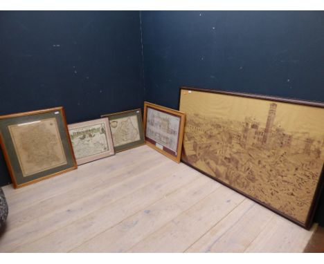
Bowen (Thomas) London to Shrewsbury and Welshpool in Montgomery, road map, published in the Gentleman's Magazine 1765-1775, engraving, unframed, 19 x 28.5cm 19 x 30.5cm, together with a Jenner (T) redrawn edition of J van lengeren's map of 1635 with triangular distance table, engraving, unframed, in three parts, (4)


Lot 490
Rocque (John) Map of Salop, printed in 4 sheets, 1752, inscribed: 'To his Royal Highness George Prince of Wales & c. This Actual Survey of the County of Salop is most humbly Inscribed By his Most Dutiful and most Obedient Servant, John Rocque. Published according to Act of Parliament by John Rocque in the Strand, Corographer to his R.H. the Prince of Wales, 1752.'engraving, unframed, each sheet 67 x 52cm (SH) (4)


Lot 493
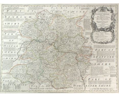
A collection of unframed engraved maps of Shropshire: H.Moll, Shropshire 1724, T.Hutchison, A Correct Map of Shropshire 1748, J.Cary, Shropshire 1787, T.Kitchen, A New Map of Shropshire 1764/68 and J.Lodge, A New Map of Shropshire 1790, together with a further nine assorted 19th and early 20th century maps, various sizes (5)


Lot 499
A Collection of unframed engraved Shropshire maps: Shropshire 1803/6 by J Luffman, Shropshire 1808 by G.Cole, Sjropshire 1816 by G.Cole, langley's New Map of Shropshire 1817, Shropshire 1823 by J Thomson, Miniature map of Worcester, Shrop and Stafford 1823 by Perrot, Shropshire 1809/1824 by G A Cooke, Shropshire 1852 by B. Moule, Shropshire 1852 by B.Moule, Shropshire by James Pigot and Shropshire 1769 by Thomas Read, various sizes (11)


Lot 607
Otacilia Severa (Philip I, 244-249), Tetradrachm, Syria: Antiochia ad Orontem, AD 248; BI (g 11,80; mm 25; h 6); MAP ?TAKI?I CEOYHPAN CEB, diademed and draped bust r., Rv. ??HMA?X E?OYCIAC ??ATO?, eagle standing r., spread wings, with wreath in beak; in ex. ANTIOXIA / S C. Prieur 387.Very rare, good extremely fine.

Lot 800
BIBLE. KING JAMES OR AUTHORISED VERSION, THE GREAT 'SHE' BIBLE, 1613 large folio, first edition (Ruth, Ch.III v15 "She Went into the Citie."), wanting general title and all before the final 6p of the Translators to the Reader, Kalendar, Almanac dated 1603-1641, genealogies by John Speed, wanting map, text of two columns of 59 lines, wood engraved NT title dated 1611, head and tailpieces and initials, pasted paper correction slip Jesus for Judas at Matthew Ch XXVI v36, I Corinthians and II Corinthians instead of I Chronicles and II Chronicles in the name and order of the Bookes, early ownership signature (Benjamin Dauntrey?), last few leaves damaged or deficient ending at Revelation ChXX v12, 18th century reversed calf Since cataloging it has been drawn to our attention that there is certainly one leaf missing from the old Testament (possibly others) Sold not subject to return
Lot 817
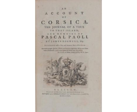
BOSWELL (JAMES) AN ACCOUNT OF CORSICA THE JOURNAL OF A TOUR TO THAT ISLAND AND MEMOIRS OF PASCAL PAOLI, 1768 8vo, first edition, folding map, engraved title, half title, 382p, tree calf, spine gilt with red ticket, R & A Foulis for E & C Dilly, Glasgow Provenance: Hugh Montgomerie, 12th Earl of Eglinton (1739-1819) (engraved bookplate). Lord Eglinton's uncle Alexander Montgomerie, 10th Earl of Eglinton was a friend of Boswell and is frequently referred to in Boswell's London Journal of 1762-3. Eglinton was murdered in 1769 and succeeded by his brother Archibald Montgomerie, 11th Earl of Eglinton, who was Robert Burns' patron.
Lot 482
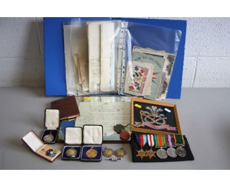
A COMPLETE AND VERY IMPORTANT ARCHIVE OF MEDALS AND SERVICE EPHEMERA, to a member of the 6th Btn North Staffordshire Regiment, who was a Veteran of the 'D' Day landings 'Operation Overlord' in June 1944, 5038238 Private, later Company Sgt Major & WO 2.John Coleman, this archive consists of the 1939-45 & France/Germany Stars, Defence and War medal, together with the Territorial Efficiency medal, correctly named to 5038238 WO.Class2. J Coleman, North Staffs, together with certificate of issue and original fibre dog tags, soldiers Service and paybook, six boxed and loose silver & silver gilt Shooting medals for Coleman from the Lichfield Miniature Rifle club, two are named on the reverse J.Coleman, metal North Staffs tie bar, four original WW2 period patches for the North Staffords, and 59th Staffs Division/21st Army group, a number of original maps for the D Day landings including area of Arromanches,(Gold Beach) The overlay map of the Bocage are back from the Beaches,& a further map of the area around Caen, also present is the original cover from the Daily Herald dated Friday August 11th 1944, concerning the landings, original Soldiers release book for Coleman, giving his date of birth as 11th October 1901, information from the Family States that he was evacuated back to the UK with an injury, but went back to France and served with the push to Paris and its liberation, The archive includes many original black and white photos of his time in Paris, with menu cards tourist pamphlets etc, and some original French Resistance photos of their struggles with the Nazi's, there is also a printed letter from Dwight Eisenhower, Supreme HQ AEF, finally a framed certificate from Commander Home Forces dated 4 June 1943 to Coleman & a framed North Stafford crest, a historical and important archive to a D Day veteran
Lot 459
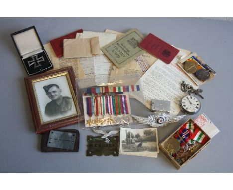
A FAMILY ARCHIVE OF MEDALS AND OTHER RELATED PAPERS AND ITEMS, relating to a father and Sons Service in WW1 and WW2. Firstly a British War & Victory medal pair, correctly named to 860T.C. H Coxall, TR.CK. (Trawler Cook) Royal Naval Reserve. He is listed as a Casualty when the Steam Trawler 'Corella' out of Grimsby was lost on 30th September, 1919. He was 37 years. With Pensions and issue slip paperwork, and what appears to be a locker or bed plate engraved H Coxall, secondly the WW2 group of medals and miniatures relating to his Son John Steven Coxall. 2387868 consisting of 1939-45, Italy, Africa stars and War Medal,(all un-named) the miniatures have the France & Germany Star and Defence medal in the group? It would appear that Coxall was taken POW possibly during the Africa or Italy Campaigns, and found himself interned at Stalag X1A near Magdeburg, Germany, this Camp was also known as Stalag 341,the medals come with Original documents from the Red Cross including Camp location map, advice booklet for relatives, and a metal plate with the markings of Stalag X1A on it and the POW ID Number 141718, this was Coxalls POW number, Army Form B104, press cutting, ID Card, and Driving Licence, together with a further Licence for Edna Mary Coxall, boxed WW1 era German Iron Cross possibly silver marked KO on reverse, small silver coloured luftwaffe Eagle/Swastika Cap device, and a further German hat badge, together with a small pocket lighter marked JSC, there is also a framed 4'x6' picture of Coxall, together with a silver pocket watch and chain, a lovely family archive
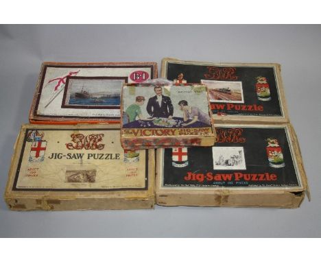
Lot 620
A COLLECTION OF VINTAGE WOODEN JIGSAW PUZZLES, Chad Valley / Great Western Railway 'The Cheltenham Flyer', 'Swansea Docks' and 'Oxford', first two are complete, 'Oxford' is missing one piece, 'Cheltenham Flyer' includes a G.W.R. publications and jigsaws catalogue, information on the Cheltenham Flyer train and a G.W.R. Map, with a Chad Valley / British India Steam Navigation promotional jigsaw showing 'T.S.S. Matiana', missing two pieces and a boxed Victory wooden jigsaw with one piece missing and two similar complete unboxed items, all boxes are damaged (7)


Lot 179
Mark R Myers The Mary Rose off Southsea Castle Colour etching signed and dated 23.11.1982 in pencil, 40cm x 51cm A copper engraving after A. Wilde Parsons 'Beating to Windward' 10cm x 14cm and a print of a canal barge Together with a map of South Africa from 'The Citizen's Atlas' 33m x 43cm, a map of Spain and Portugal by Phillip Smith 30cm x 39cm and a map of Berkshire 22cm x 27cm


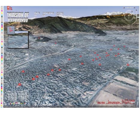
Lot 368
δ Invader (b.1969) Kathmandu map Offset lithograph printed in colours, 2008, signed and numbered from the edition of 50 in pencil, on stiff wove paper, the full sheet printed to the edges, sheet 400 x 600mm (15 3/4 x 23 5/8in) (unframed) δ This lot is sold subject to Artists Resale Rights, details of which can be found in our Terms and Conditions.


Lot 40
A QV to QEII mainly mint collection of Falkland Island stamps in a Plymouth album including 1898 CC 2/6d and 5/-, 1904-12 MCA to 3/-, 1912-20 MCA to 10/-, 1929-37 Whale and Penguin set to £1, 1933 Centenary to 5/-, 1938-50 to £1 (also used), Depencies with 1946-49 thin map set in plate blocks, 1963 values to £1 ultramarine in imprint blocks, etc.
Lot 491
Three 'Le Blond-Baxter' prints, an over painted portrait miniature, 9 C19th etchings & engravings, after Kip 'Bryanstone in Dorsetshire' engraved map & a Continental portrait of a Gentleman PLEASE always check condition PRIOR to bidding, or email us a condition report request if you can't attend in person


Lot 224
The Imperial Gazetteer of England and Wales, John Marius Wilson, Vol I and II, A Fullarton & Co, 1880; Annals and Antiquities of the Counties and County Families of Wales by Thomas Nicholas, London, 1872; A Topographical Dictionary of Wales by Samuel Lewis, in two volumes, third edition, London, 1845; two volumes of Lewis's Map of England and Wales N-W division and S-W division; and The History and Antiquities of the County of Cardigan by Samuel Rush Meyrick, Brecon, 1907, Davies & Co, quarter bound in black calf


![A GROUP OF 10 EARLY SOVIET CHILDRENS BOOKS comprising:a) Lesnoy razvedchik [Forest Scout]. Moscow-Leningrad: OGIZ - Molodaya](https://cdn.globalauctionplatform.com/2d77c086-0bca-421f-83b1-a729016a0190/60dba5a4-0e3f-49ce-9d2e-e74df1215c66/468x382.jpg)
Lot 202
A GROUP OF 10 EARLY SOVIET CHILDRENS BOOKS comprising:a) Lesnoy razvedchik [Forest Scout]. Moscow-Leningrad: OGIZ - Molodaya Gvardiya, 1931. 12mo (176 x 129 mm)b) Shutki-pribautki [Jokes]. Moscow-Leningrad: Raduga, 1929. 12mo (180 x 145 mm)c) Nashy vragi [Our Enemies]. Moscow-Leningrad: Raduga, 1928. 12mo (180 x 143 mm)d) Negramotnyi [Illiterate]. Moscow-Leningrad: Raduga, 1928. 12mo (180 x 145 mm)e) Raskraska No 3 [Coloring Book No 3]. Moscow-Leningrad: Raduga, 1920s. 12mo (190 x 148 mm)f) Nebylitsy [Fish Story]. Moscow-Leningrad: Raduga, 1920s. 12mo (192 x 145 mm)g) Fedorino Gore [Fedora`s Sorrow]. Leningrad: OGIZ, 1935. 12mo (197 x 150 mm)h) Inostranka [Foreigner]. Moscow-Leningrad: DETIZDAT, 1937. 12mo (193 x 138 mm) i) Pyat Kolets [Five Rings]. Moscow: OGIZ, 1931. 8vo (220 x 173 mm) j) Tchasy i karta Oktyabrya [Clock and Map of October]. Moscow-Leningrad: GIZ, 1930. 12mo (210 x 172 mm)


-
109182 item(s)/page