

EARLY PRINTING: NEVILLE, Alexander: De furoribus Norfolcensium Ketto Duce.eiusdem Norvicus. Henrici Binnemani, 1575, 1st. edn. First issue; 2 parts/vols in 1. Small 4tol. PP: (xiii), (iii) blank, 156; (xi), (i)b, 207, (xxvii), (i)b. Colophon dated 1576. With two title pages & the Arms of Archbishop Parker on verso of both title pages. Bound with: Apology to the Welsh. Later full calf, with earlier spine. VG [The first part comprises a contemporary history of Kett’s rebellion of 1549; and On p.32 there is the famous passage speaking of the laziness of the Welsh levies and comparing them to sheep, which at the insistence of an offended government was excised from later issues].Provenance: The Peter and Pat Crofts CollectionCondition ReportTwo pages are torn, one with a small hole, some foxing and discolouration, there is no map present.
We found 109198 price guide item(s) matching your search
There are 109198 lots that match your search criteria. Subscribe now to get instant access to the full price guide service.
Click here to subscribe- List
- Grid
-
109198 item(s)/page
![MILITARY: [Kane, General]: A System of Camp Discipline, Military Honours, Garrison-Duty, and other Regulations for the Land F](https://cdn.globalauctionplatform.com/77e1096b-5fc9-4299-bd4d-aee500f847b7/228b360e-3d49-4f4d-b01e-aee700f15eb6/468x382.jpg)
MILITARY: [Kane, General]: A System of Camp Discipline, Military Honours, Garrison-Duty, and other Regulations for the Land Forces, 1757, 2nd. edn. With a folding hand coloured map (torn with loss), 20 plates, some hand coloured (6 torn with small loss) & a folding table (torn with loss). Cont. full leather & later spine; Plus Six other military works, 1821-1929. (7)Provenance: The Peter and Pat Crofts Collection
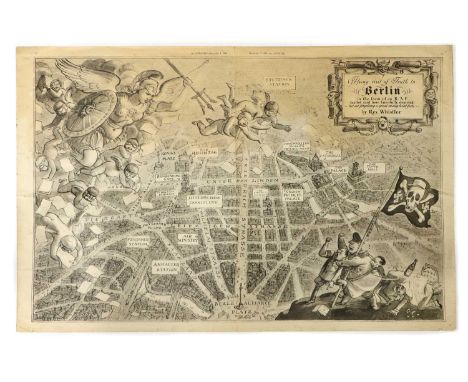
WHISTLER, Rex: Flying Visit of Truth to Berlin in the form of an R. A. F. leaflet raid here fancifully depicted - but not forgetting a great many hard facts, The Illustrated Magazine, Dec 9th, 1939, black and white satirical map of an aerial view of Berlin (520 x 325mm), Folded twice, small tears to the blank edges, no loss.Provenance: The Peter and Pat Crofts Collection

AMERICAN INTEREST: Catlin, G: 1- Letters & notes on the manners, customs & condition of the North American Indians, 2 vols. Printed for the author by Tilt & Bogue, 1842, with a folding map & numerous line drawings. Cont marbled boards 7 later cloth spine & endpapers; 2- Life amongst the Indians. Sampson Low, 1861, with 14 engravings. (3)Provenance: The Peter and Pat Crofts Collection

AMERICAN INTEREST: Burnary, A: Travels through the middle settlements in North America in 1759 & 60. Payne, 1775. Later plain boards & new endpapers; title page relaid, with small loss to top margin; last page torn, without loss; [Franklin, Benjamin, and Richard Jackson]: An Historical Review of the Constitution and Government of Pennsylvania.. London: R. Griffiths, 1759, 1st. edn. Cont. full mottled calf, recased with the original spine; [Jun, JC]: the United States and Canada as seen by two brothers in 1858 & 61. 1862, 1st. edn. With a folding coloured map (tears to folds). Original cloth, rubbed & cuts to spine; EMORY, WH: Notes of A Military Reconnoissance from Fort Leavenworth, in Missouri, to San Diego, In California. Washington, Wendell.. 1848, With 41 plates, LACKING THE FOLDING MAP; Act of Parliament for encouraging making of pott ashes & pearl ashes in the British plantations in America. 1751. PP: TP, 1107-1111, Plain boards; Plus 3 others. (8)Provenance: The Peter and Pat Crofts Collection
![[BLAEU, Joan]: MAP of Somersetshire- Somerset: Tensis Comitatus. | Somersetshire. (1648), Hand coloured (510 x 400mm); mounte](https://cdn.globalauctionplatform.com/77e1096b-5fc9-4299-bd4d-aee500f847b7/f1f72b51-c04d-47f1-bd77-aee700f10bbb/468x382.jpg)
[BLAEU, Joan]: MAP of Somersetshire- Somerset: Tensis Comitatus. | Somersetshire. (1648), Hand coloured (510 x 400mm); mounted, framed and glazed; Plus: Bowen, E: An Improved Map of the County of Somerset, Divided into its Hundreds, C1760, Hand coloured (510 x 400mm); mounted, framed and glazed. (2)

THE FENS: Miller (SH) & Skertchly (SBJ): THE FENLAND PAST AND PRESENT, FOLIO Edition. Wisbech, Leach & Son, 1878 1st. edn. PP: xxxii (including Subscribers’ list), 649. Folding map & 25 plates (one coloured). Half leather over marbled boards, marbled endpapers & top edges gilt. Covers little rubbed; map torn at fold (without loss); scattered spotting. Nice CopyProvenance: The Peter and Pat Crofts Collection


FENLAND, LINCOLNSHIRE, NORFOLK, ETC. Large quantity including: White’s Gazetteer & Directory of Lincolnshire, 1872, PP: 884, (ii), 78 (adverts). Later cloth & new endpapers, bound without the map; Rackham, A (ill): Sunrise Land, 1894; Thew, J: Report of an enquiry… corporation of King’s Lynn, Norfolk. Stamford, 1833, 1st; Wisbech Working Man’s club & Institute, 1884-95, 12 (years); The Gentlemen’s Society of Spalding, its origin & progress, 1851, 1st. Etc. (qty.)Provenance: The Peter and Pat Crofts Collection
FEN History: 1- ELSTOBB, W: An Historical Account of the Great level of the Fens, Called Bedford Level, and other fens, marshes and low-lands. Lynn, W. Whittingham & sold by S. Crowder, 1793, 1st. edn. PP: viii, (xi) Subscribers list, (i) adv, 276, (4) adv.+ large folding Map. Later half leather, scattered spotting; one page with a tear and old repair; 2- Wheeler, WH: History of the Fens of south Lincolnshire. Boston, 1868, 1st. edn. The Author’s own copy, interleaved with his notes and corrections throughout. Original cloth; rubbed; the map with a tear; 3- Another copy; 4- Johnson, C: Account of the trial & execution of the Ely & Littleport rioters in 1816. Ely, 1893, 1st. PP: 77, (vii) adv.. Original wrappers; edges frayed; Plus Ten others. (14)Provenance: The Peter and Pat Crofts Collection

FENLAND Topography: Johnson, E (Photo): The Fen & Marshland churches, A series of Photographs.. 3 Vols. Wisbech, Leach, no date, c1869-76, With 47 photographic plates + 9 ground plans. Half leather; rubbed; Skertchley: Geology of the Fenland. 1877, 1st. 24 plates & maps; Miller & Skertchly: Fenland past & present. Wisbech, 1878, 1st; Heathcote: Reminiscences of Fen & Mere. 1876 1st. Plates & maps; Small stain to edges of few pages; Miller: Hand-book to the Fenland. 1890, new edn. folding Map; Clarke: Fen sketches. 1852, 1st. PLUS 9 others. (17)Provenance: The Peter and Pat Crofts Collection

MAPS (IRBY, Frederick, Baron Boston of Boston, Lincolnshire): LENNY, J: A unique collection of 9 Maps on Vellum, Drawn by J. Lenny, comprising of: Seas End farm, Moulton estate & Fens (3 maps); New Sea Bank to the Roman Bank; Roman Bank to the Turnpike; Turnpike to Austen Dike, Austen Dike to Chaper; Chaper to the Load Bank. Folio, each map with a small vignette and calligraphic dedication leaf, interleaved with paper. Original full red morocco gilt & lettered "Plans' ' to upper cover, which is detached.Provenance: The Peter and Pat Crofts Collection

MAPS/Marshland- Utting, J: 1- Plan of the survey & levels of the sewers, drains, bridges, tunnels & sluices in the parishes of the county of Marshland.. 1824, Very large (1,800mm wide), tears and some loss; 2- Plan of the levels taken in Marshland Smeeth & Fen, Norfolk, 1827. Hand coloured & rolled; PLUS: Hart, J C (Engineer):Map of an estate in Marshland, the property of Gustavus Helsham, 1894. Hand coloured, linen backed & rolled (2,850 x 1320mm). (3)Provenance: The Peter and Pat Crofts Collection
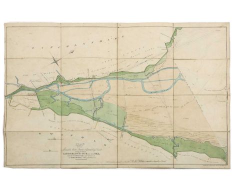
![NAVIGATION: 6 tracts Bound in One vol: 1- [kinderley, C]: Ancient & present state of the navigation of the towns of Lynn,](https://cdn.globalauctionplatform.com/77e1096b-5fc9-4299-bd4d-aee500f847b7/e1e7d8d8-8ac0-42da-9539-aef30117ac62/468x382.jpg)
NAVIGATION: 6 tracts Bound in One vol: 1- [kinderley, C]: Ancient & present state of the navigation of the towns of Lynn, Wisbech, Spalding & Boston, 1751, with a folding map; 2- The Claim of taxing the Navigations and free lands for the drainage ... of the Fens, 1793; 3- An Abstract of the Case and Opinions that have appeared in print for and against the Eau Brink Cut, 1794; 4- Observations upon some of the clauses of the bill.. For settling the draining of the ... Bedford Level, 1808; 5- Report of the joint committee of drainage & navigation.. No title page; 6- Letter to his Grace the Duke of Bedford, governor of the Bedford Level Corp.. On the works in the New Bedford.. The river Ouze.. 1828, with 3 folding Maps. Half leather, rubbed.Provenance: The Peter and Pat Crofts CollectionCondition ReportPlease see images for condition.


MAPS: Collection, including: 4 by Morden, Hand coloured Map of Huntingdonshire. Nd, c1640. (450 x 390mm); Hand coloured Map of Lincolnshire, c1695, (480 x 420mm); Map of Norfolk, nd, folded (600 x 400mm), edges frayed; Hand coloured Map of CAMBRIDGESHIRE. Abel Swal, nd; Plus: Walker: CAMBRIDGESHIRE. Hand coloured Map, 1837, Folding, (480 x 350mm); Moore: Map of The Great Level of the Fenns from a map of 1684. 1720, (410 x 300mm); Grundy: Ancient river Witham, 1743. (740 x 470mm); Plus 9 others. (qty.)Provenance: The Peter and Pat Crofts Collection

RAILWAY MAPS: Plan of the section of the Lynn & Ely Railway, with a branch to the harbour at Lynn & main line to Wisbech, survey under the direction of J U Rastrick, 1844; (1320 x 670mm). With tears and repairs; A Map of part of Wisbech and the projected lines of Railway through the town, by W Adams, Wisbech, Jan, 1846, (900 x 680mm); with tears (2)Provenance: The Peter and Pat Crofts Collection.

NAVIGATION: Treatise on inland navigation: illustrated with a whole-sheet plan, delineating the course of an intended navigable canal from London to Norwich and Lynn, through the counties of Essex, Suffolk, and Norfolk.. For S Hooper, 1785. PP: xii (including subscribers list), 50, plus only one large folding hand coloured map of the course, lacking the plate with two plans. Mss notes to the margin of a few pages. 4to, later cloth; Abstract of the minutes of evidence, taken before a committee of the House of Commons during the session of 1826 on the Bill for making Navigable communication for ships & other vessels between Norwich & the sea at or near Lowestoft. Norwich, 1826, 1st. 56pp Plus a folding hand coloured Map. Original printed wrappers; Moore, JH: The new practical Navigator. 1814. With ONLY 10 plates, lacking the two plates at the end. Cont. full leather & later spine. (3)Provenance: The Peter and Pat Crofts CollectionCondition ReportImages are now correct on our website.
WISBECH: A collection of books relating to Wisbech including: Walker & craddock: History of Wisbech & the Fens. Wisbech, 1849, 1st. edn. Subscribers’ copy. Map & 19 Plates. Cont. half leather, rubbed; History of Wisbech with an historical sketch of the Fens. Wisbech, 1834, original boards, rubbed (2 copies); An historical sketch of Wisbech & its vicinity.. Wisbech, J White, 1809, with a hand coloured frontis. Later leather backed boards, VG; the charter of the town of Wisbech.. Wisbech, 1815. Folio, recent cloth backed boards & title to upper, VG; Hutchesson: Introduction to the Charter of Wisbech. Wisbech, 1791. 4to. 22pp later leather backed boards; Plus 9 others (Complete list available). (16)Provenance: The Peter and Pat Crofts Collection

Hanging MAPS: Runcton Holme. No date, hand coloured, 1200mm wide; with tears; Map of the town of Wisbech with new Walsoken, reduced from the board of health map, revised by Charles Munford. Wisbech, 1867; (1300 x 1050mm); yellow & cracked with age; few tears & some loss. (2)Provenance: The Peter and Pat Crofts Collection

Wisbech, Etc: Gordon: Parish and Manor of Nassington - Cum- Yarwell, Oundle, 1890, 1st. 4to. With a map + 8 plates; vg; Six Pamphlets bound in one vol- Wisbech, Bedford Level, Lynn, etc.1824-1829; Seven Pamphlets in one vol. Syllabarium Hebraicum, 1808; Sale catalogue; Labour Poor; Anti-Malt-Tax, flyer; Etc. Recent half leather; Harrod, H- Report on the Deeds and records of the borough of King's Lynn. Kings Lynn, 1874, with 8 plates, including a hand coloured frontis, 4to; Storr's impartial narrative ... Grantham election, 1820; Plus 9 various Pamphlets. (14)Provenance: The Peter and Pat Crofts Collection
MAPS (Cambs.): Whittlesey Fen: An exact survey of these grounds herein specified.. Being parcel of the possession of W J Cropley of London, taken in 1651 by Robert Smith (560 x 460mm), on linen & folded; Map on vellum, of the Rectory of Reverington & Reverington Parson drove, Ely, from an actual survey taken in 1792. (1500 x 650mm); Hand coloured and rolled; BOWEN, E: An accurate map of Cambridgeshire divided into its Hundreds.. Printed for R. Wilkinson, no date c1763; hand coloured in outline & with a view of the S.E. prospect of Ely. Rolled, with tears & repair from the back; Darton, W: Map of Cambridgeshire divided into hundreds & the parliamentary divisions, 1830; hand coloured, linen backed & folding, with a view of Ely Cathedral, (480 x 370mm); slightly soiled. (4)Provenance: The Peter and Pat Crofts Collection

Hanging MAP, Cambridge & Ely: Map of the county of Cambridge & Isle of Ely, Surveyed by RG Baker, 1816, 17,18,19,20; republished in Earith, near St. Ives, Huntingdonshire, May 1st. 1830, & sold by T Stevenson, Cambridge. Hand coloured, linen backed & with two views: Cambridge & Ely, (1550 x 1250mm)Provenance: The Peter and Pat Crofts Collection

CAMBRIDGE: Mackenzie: The Cambridge Guide, or, a Description of the University and Town of Cambridge. Deighton, Cambridge, nd (1830), new edn. With a folding plan + 32 engravings on 8 sheets. Full polished leather, G+; Meason, G: Official illustrated guide to the Great Eastern Railway: 1- (Cambridge Line). Griffin (1865), With a folding map (tear to fold), + numerous engravings, 365pp; Bound With: 2- (Colchester Line). With a large folding map (tear to fold), 436pp. Original cloth, rubbed; Boissier, GR: Notes on the Cambridgeshire Churches. 1827. With a frontis, folding map Plus 12 plates on 3 sheets; G+; Gardner’s History Gazetteer & directory of Cambridgeshire, including Isle of Ely. Peterborough, 1851 1st. edn. Subscribers’ copy. 744pp; Kelly’s Directory: Cambridgeshire. 2 Editions, 1883 (lacks the map)& 1892, with the map; Clay, WK: A history of waterbeach. 1859, 1st. edn; Etc. (23)Provenance: The Peter and Pat Crofts Collection

Norfolk: Erratics by a sailor, containing rambles in Norfolk & elsewhere. 1800, half calf; Hartshorne: on the drainage of the Nene valley- a report. 1848; 9 Acts of Parliament relating to Norfolk, Bound in one volume 1801-1815; Norfolk Estuary works, Proceedings in Parliament, 1853; White’s History, Gazetteer & Directory of Norfolk, three editions: 1854-1883 (all lacking the map); Plus one other, A/F. (8)Provenance: The Peter and Pat Crofts Collection

Norfolk/Ephemera: Minroy: Lectures on drainage, 1847; Beloe: Padder’s way.. 1896. Folding coloured map & plates; Collection of Norfolk Bookplates; Coleridge: the Royal West Norfolk Golf Club. 1st. Fine; Plus a collection of Prints, Flyers, 1st. Day covers; etc. (qty.)Provenance: The Peter and Pat Crofts Collection

Bryant, A: Map of the county of NORFOLK from actual survey by A Bryant made in the years 1824, 25 & 26, respectfully dedicated to the nobility, clergy & gentry of the county. A Bryant, Dec 1st, 1826. Published in two parts, North and South each 2280x720mm. Linen backed and hand coloured. Housed in a cont. full leather box.Provenance: The Peter and Pat Crofts Collection

MAPS/Norfolk- Map of the frontages in commons in the parishes of Terrington St. Clements & St. John's as they are allotted, divided, enclosed & awarded by the parliament 1791-92 by J Watte. Hand coloured & linen backed, with a couple of tears (2200 x 260mm); Northwold, Norfolk: Map on vellum, 1798. Some hand colouring (1820 x 760mm); Plan of the Parish of Terrington St. John, Norfolk, 1826. Hand coloured (1040 x 760mm); Parish of Dersingham, Norfolk, 1839; hand coloured, linen backed & rolled (1900 x 670mm); Parish of North Runcton, Norfolk. Goodwin, Lynn, copied by WS Clarke, 1841 (the date: 1839 added in ink to the title). Hand coloured & linen backed (1080 x 720mm); Plan of the Parish of Terrington St. John, Norfolk, J Utting, Lynn, no date, hand coloured (980 x 640mm); Plus one other, A/F. (7)Provenance: The Peter and Pat Crofts Collection

MAPS/Norfolk-Plan of the parish of Tilney cum Islington, Norfolk, J Utting, Lynn, 1828. Hand coloured (1100 x 760mm), few tears; Map of Walpole Township, Norfolk (Walpole St. Andrews & Walpole St. Peter), copied in 1845 from one prepared in 1840 (2100 x 1340mm); Map of Sedgeford, Norfolk, copied in 1839 from the award map of 1797. Hand coloured & linen backed (1000 x 770mm); Terrington St. Johns, Norfolk, copied in 1848 from one prepared in 1826. J Utting, Lynn. Hand coloured & linen backed (1000 x 620mm); Terrington St. Clement. Goodwin, Lynn, 1849. Copied from a map prepared in 1824, hank coloured & linen backed (1450 x 760mm); West Walton, Norfolk, copied in 1848 from one in 1820. Hand coloured, linen backed & rolled (2000 x 960mm); Plus 2 others, A/F. (8)Provenance: The Peter and Pat Crofts Collection

MAPS/Norfolk- Hand-drawn map on vellum, coloured & with Shield: Some lands belonging to Capt. W. Hudson in the Parishes of Grimston & Bawsey, Norfolk, 1756; (900x690mm); Browne: Hold lands and M Partridge’s estate at Northwold, Norfolk, 1829, hand coloured & rolled. Tears at both ends. (1200x650mm); Goodwin Partridge & Williams: Map of the parish of West Winch, Norfolk, 1839. Hand coloured, linen backed & rolled (860x610mm); Smeeth & Fen allotments: Goodwin & co., Lynn, copied in 1848 from maps prepared between 1824 and 1840; (960x650mm); Farm at Wiggenhall St. Mary Magdalen, belonging to E Peel.. 1876, hand coloured (1,200x530mm); Kell, T: River Nene from Peterborough to the Wash, Hand coloured & folding; bound in plain paperboards, (740x330). (6)Provenance: The Peter and Pat Crofts Collection
MAPS/Norfolk: Map on vellum of Heacham, copied from the award map, J Browne, Norwich; (720 x 680mm). Hand coloured; little grubby; Copy of the plan of the parish of Holme Next the Sea, Norfolk, J Dugmore, 1827, hand coloured on vellum (720 x 580mm); PLUS the particulars referring to the said map, with prices etc. Both rolled and housed in the original tin; Heacham & Snettisham: Plan of the proposed drainage improvement on the estate of H L Syleman Le Strange. 1851, (2500 x 800mm). Hand coloured, linen backed & rolled; a few small tears, o/w G+; H L Syleman Le Strange. plan and sections of part of the sea beach at Heacham, 1871. Hand coloured & linen backed, (2900 x 660mm). Light water stain to a small part, o/w VG. v nice; Another one for Snettisham, 1871; Hand coloured, linen backed & rolled, (1900 x 650mm); Holme & Outfal, embankment and drainage: 2 maps. 1870; Map of the sands between Kindersley's cut and the sea made by Thomas Pear, c1800; Hand coloured, linen backed & rolled. (770 x 550mm). (8)Provenance: The Peter and Pat Crofts Collection
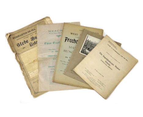
AUCTION CATALOGUES: Five Catalogues, including: Charles Hawkins & John D Wood: Ingoldisthorpe Manor Estate, Hunstanton, Norfolk, 1929. 4to. 37pp+plates & folding map, with stamped & dated receipt for the sale of lot 7. Original wrappers; Edmond Beck & Sons: West Norfolk Freehold estate.. 1913, Folio, 50pp + 5 folding maps. Original wrappers, VG; Heacham on coast, near Hunstanton, 1915; Hunstanton, Globe building Estate, nd; & Wisbech sale of 'Rose & Crown' Hotel, 1932 (5)Provenance: The Peter and Pat Crofts Collection
NORFOLK/SUFFOLK: Memorials, Archaeological and Ecclesiastical, of the West Winch Manors, 1861, 1st. edn; Le Strange: Address from the Gentry of Norfolk & Norwich.. 1913, Limited edn. #19/350, Signed; Brayley: Views in Suffolk, Norfolk & Northamptonshire, 1818, with plates; History & Antiquities of Norfolk, vols: 1, 5 ,& 6. Norwich, 1781. With folding maps & plates; Munford: Attempt to ascertain the true derivation of the names of towns, villages & rivers.. in Norfolk.1870, 1st; Woodward: Descriptive outline of the Roman remains in Norfolk. 1831. 4to. With a Map & 10 plates, all hand coloured; Plus 9 others. (qty.)Provenance: The Peter and Pat Croft Collection

Map showing the land to be reclaimed from the Norfolk and Lincolnshire Estuary, Also that which has been Reclaimed from time to time: Part of Norfolk Cambridgeshire, Lincolnshire and Bedford Level with the recent Drainage Improvements in the Middle Level of the Fens and the Rivers, Cuts, Canals and Railways communicating therewith. King’s Lynn, W D Harding, (1825). Folding hand coloured linen backed & measuring (1250x1000mm), with the original half leather covers, morocco label to upper cover and title to pastedown.Provenance: The Peter and Pat Croft Collection

Bryant, A: Map of the county of Lincoln from a survey made in the years 1825, 26 & 27. A Bryant, April 18, 1828. Published in two parts, North and South. Linen backed and hand coloured. The south part has a view of Lincoln Cathedral. Housed in the original full calf case, with lid. VGProvenance: The Peter and Pat Croft Collection

Major COLBY: Ordnance survey map of Lincolnshire, in 8 parts: 1- Sleaford, Spalding & Newark on Trent; 2- Lincoln, Market Rasen & Horncastle; 3- Hull & Barton on Humber; 4- Spurn Head; 5- Peterborough, Oundle, Melton Mowbray; 6- Downham market; 7- Holbeach, Castle Rising & Boston; 8- Loath. Published at the Tour of London, 1st. March 1827, by Major Colby. All eight maps are folding, hand coloured and linen backed, each measuring 950 x 650mm. Housed in the original full leather box, lid torn with loss; maps VGProvenance: The Peter and Pat Croft Collection

Map of the County of Lincoln from an Actual Survey made in the Years 1827 & 1828. Greenwood & Co. Feb. 24, 1830. In three large folding linen backed parts (North, Central & South), each measuring 1560 x 700mm. Housed in a near cont. marbled boards slipcase.Provenance: The Peter and Pat Croft Collection

LINCOLNSHIRE: ARMSTRONG, ANDREW. Map of Lincolnshire, comprehending Lindsey, Kesteven & Holland, surveyed in the Years 1776, 7 & 8. Engraved by Stephen Pyle, 1778. With 8 double-page maps (including the title page), some hand-coloured, 750 x 529 mm each; total size: 2080 x 1460 mm. Index booklet at the end dated Jan. 1779. Large folio, soft leather; rubbed & torn; light damp stain to the title page and the last map.Provenance: The Peter and Pat Croft Collection

AXHOLME: 1- Stonehouse, W B: The History and Topography of the Isle of Axholme: Being That Part of Lincolnshire which is West of the Trent. Longman, et al, 1839, 1st. edn. With 14 maps & plates, some hand coloured. 4to. Annotated copy, Cont. half leather, rubbed; frontis map frayed at edges & with tears and small loss; another plan frayed at edges and dusty; 2- Fletcher, T C: Read's History of the Isle of Axholme. Read & Co., Epworth, no date (1857), 1st. edn. With 3 large folding colour maps, 12 plates (6 Sepia), & 2 folding pedigrees. Covers rubbed and hinged cracked. (2)Provenance: The Peter and Pat Croft Collection

LINCOLNSHIRE Directories, etc: White, W: The History and Directory of the Towns and Principal Villages in the County of Lincoln. Leeds, 1826. No map present. Cont. full calf & later spine; Another copy, 1856, 2nd. edn. Cont. full calf; rubbed; Morris & Co's Commercial Directory and Gazetteer of Lincolnshire: Subscriber's copy. Nottingham,1863. With 140pp of adverts. Original cloth gilt; rubbed & with tears; [HOWLETT, B]: A Selection of Views in the County of Lincoln.. 1805, 1st. edn. Large 4to. Hand-coloured frontis Map plus 53 plates. Occasional browning; Wheeler, WH: History Of The Fens Of South Lincolnshire. Boston, nd, 2nd. edn. 16 ill. Cloth, rubbed; NOBLE, J: Gazetteer of Lincolnshire.. Hull, 1833 with a folding map of Lincolnshire & folding Bradshaw’s map of the railways. Annotations to verso of the map, etc. A/F. (6)Provenance: The Peter and Pat Croft Collection

LINCOLNSHIRE: WEIR, G: Historical and Descriptive Sketches of the Town and Soke of Horncastle.. 1820, 1st. edn. With 8 plates, including 2 double-page plans & 1 hand coloured plan. Cont. half leather; rubbed; Notitiae Ludae, or Notices of Louth. Louth, 1834, 1st. edn. Folding map & 5 plates. Later ¾ leather, teg; VG; Lincolnshire Churches: An Account Of The Churches In The Division Of Holland In The County Of Lincoln. 1843, subscribers’ copy. With 67 plates; Half leather; rubbed; History of Crowland Abbey, Digested from the Materials Collected By Mr. Gough. Stamford, 1846, with 2 plates. Offsetting & foxing; Oldfield, E: Topographical and Historical Account of Wainfleet and the Wapentake of Candleshoe, in the County of Lincoln. 1829, 1st. Edn. With plates. (5)Provenance: The Peter and Pat Croft Collection

FEN DRAINAGE: Wheeler, WH: The Drainage of Fens And Low Lands By Gravitation and Steam Power. 1888, 1st. edn. 8 folding plates; Bateson, P: Some Papers Relating to the General Draining of Marsh-land in the County of Norfolk. 1710. 24pp; Grundy, J: Observations Resulting from Surveys, Levels and Views Made on the East Fen, 1774, small 4to. 46pp & folding map; Observations on the Means of Better Draining the Middle and South Levels of the Fens. by Two Gentlemen. 1777, 4to. 31pp; West, WW: Short & concise history of the drainage of the Fens.. Wisbech, Leach, no date; Plus a note “with WW Wests compliments”. (5)Provenance: The Peter and Pat Croft Collection

DRAINAGE REPORTS: 1- Bound volume of C16 pamphlets with 7 folding plans: Including a hand-coloured plan of the Harbour & Haven of the port of Wells, Norfolk dated 1782; Engineers’ Reports, including: Smeaton, Yeoman, Golborne, Hodskinson, Watte & Rennie. Plus receipt of purchase in 1975 for £150 & detailed list of contents. Leather backed boards; rubbed & covers detached; tears to the folds of the maps; 2- MSS etc. including: Eau-Brink drainage, general half yearly meeting held at the Lamb Inn, Ely, 27-1-1843, & The Bedford Level Corp. meeting; Bound with: Sir John Rennie’s July 1, 1839 Great Level of the Wash Report; Rendel’s Report on Rennie’s plan.. 1840, 11pp + a folding Plan; A Bill for inclosing & reclaiming from the sea.. the Wash, 1840, 118pp; 3- John Watte’s Report for the better Drainage of the South & Middle Levels of the Fens. Lynn, 1791, 4to. 18pp + Large folding Map; wrappers dusty & loose; 4- Tycho Wing: Considerations on Rennie’s plan 1820; 5- John Golborne’s Report.. C1769, with a large folding map, wrappers; 6- Yeoman’s Report. 1767, with a large folding chart, wrappers; 6- Seaton’s Report, 1767, with a large folding chart, wrappers; 7- John Fowler: Nene Valley Drainage & Navigation Report. 1858; Bound with two other reports: Hurwood & M’clean. (qty.)Provenance: The Peter and Pat Croft Collection

MAPS/Fen Drainage- Bedford level. April 1789. Folding, linen backed (780 x 580mm), with marbled paper to each end and the original marbled slipcase; Martin & Hood: 1- Wildmore Fen, Lincolnshire (14th district map, no. 1), 1879. Hand coloured, linen backed & folding (980 x 700mm); few small tears to folds; 2- East Fen, Lincolnshire (14th district map, no. 4), 1879. Hand coloured, linen backed & folding (1100 x 820mm). (3)Provenance: The Peter and Pat Croft Collection

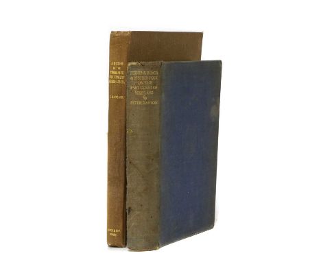
FISHING: 1- ENGLISH, TH: A Memoir of the Yorkshire Esk Fishery Association. Whitby, Forth, 1925, 1st. edn. 4to. 152pp + 17 plates, Plus an extra folding coloured sketch map of the Esk Fishery Association’s water, 1920. Plain cloth; rubbed.; (Scarce: Not many more than 50 copies printed); 2- ANSON, Peter F: Fishing Boats and Fisher Folk of the East Coast of Scotland. Dent, 1930, 1st. edn. Inscribed & Signed by the author: “To JE Douglas, in memory of days among the fishing boats & fisher folk on the East coast of Scotland, Signed & dated July 1938”. Covers rubbed and soiled, hinges cracked; one page torn off & another in the middle, but no loss. A/F. (2)Provenance: The Peter and Pat Crofts CollectionCondition ReportFishing Boats and Fisher Folk - spine detached from backboard and cover in generally poor condition, three pages torn down 50% of the page, one of which is over an illustration, some damp staining.A Memoir of a Yorkshire Esk Fishery Association - pencil inscriptions to inside back board, Peter Crofts paper label stuck to first page, some foxing throughout the book, illustrations in good condition.


London Maps: 1- Andrews's New and Accurate Map of the Country Thirty Miles Round London. Andrews, 1787. Hand-coloured, 670 x 620mm, dissected and mounted on linen with the original marbled slipcase & label; VG; 2- Pearson’s Twenty-Four miles round London, with reference to the seats of the nobility & gentry. Bowles & Carver, 1809. Hand-coloured, 650 x 650mm, dissected and mounted on linen with the original marbled slipcase & label; VG; 3- Cruchley's New Plan of London.. Improved to 1827, shewing the East and West India Docks, the London Docks, and the intended new docks of Saint Catharine’s, From Arrowsmith’s 1827. Hand-coloured, 980 x 500mm, dissected and mounted on linen with the original marbled slipcase & label. Tears to the couple of the folds. (3)

7 Original hand-coloured & mounted MAPS: TALLIS, J: Van Diemen's Island or Tasmania, (340 x 250mm); New Zealand, (350 x 260mm); Western Australia - Swan River, (320 x 240mm). All three c1851 & with views; Arrowsmith’s Van Diemen’s Land, 1828, (300 x 220mm); The cruise of the King’s fleet commanded by admiral Keppel, c1800 (240 x 180mm); SEALE: A correct Chart of the Bay of Biscay.. c1820, (460 x 360mm); Le Chili, c1840 (260 x 180mm). (7)Condition ReportAll maps are in good condition. No tears, some very minor staining to some. Tasmania map in excellent condition.

MANUSCRIPTS: Outwell, Cambridgeshire: 1- Valuation of the parish. 35pp plus a few loosely inserted, including a Map of Outwell Enclosure referred to by the Commissioners Award. 1843; 2- Josiah Robb Smokey, Outwell: Copy of the Parish Award. Written in a neat hand. Folio, full vellum. (2)Provenance: The Peter and Pat Crofts Collection


Two map engravings to include: Jan Jansson (1588-1664), 'Langvedoc', publication date 1647, with label verso, 54 x 46 cm; together with John Speede (1552-1629), map of North Yorkshire, inscribed verso: 'This map is a 2nd edition of John Speede's map and was published in 1676', 'The Description of Yorkshire' verso, 50 x 40, both framed and glazed, (2)

Four hand coloured maps to include: Robert Morden (c.1650-1703), 'Leicestershire' engraving on paper, 43 x 36 cm; William Henri Toms (c.1700-c.1755), 'A Map of Herefordshire', engraving on paper, 16 x 16 cm; 'Lancashire' by J & C Walker, 43 x 35 cm; and 'Cheshire' 26 x 20 cm, all framed and glazed (4)

Herman Moll (1654-1732), Map of Virginia and Maryland, (early 18th Century), hand coloured engraving, approx. 21 x 28 cm, framed and glazed, This map of the eastern coast of Virginia, Maryland, and the Chesapeake Bay was based on Augustine Hermann's map of 1673. The map labels counties, towns, water ways, Indian lands, plantations, and provides useful notations such as ""the swamp here not passable."" A key under the title identifies English plantations and Indian plantations and houses. This map was first published in John Oldmixon's British Empire in America, and then appeared in Moll's Atlas Minor and Thomas Salmon's Modern History: or the Present State of All Nations.


-
109198 item(s)/page