We found 109198 price guide item(s) matching your search
There are 109198 lots that match your search criteria. Subscribe now to get instant access to the full price guide service.
Click here to subscribe- List
- Grid
-
109198 item(s)/page


Lot 507
Three antiquarian maps:1. After SIMMS AND JENNER - Map of Gloucestershire (1643), hand-coloured plate (6¾ x 4¾ in; 17 x 12 cm); 2. after JOHN SPEED - Miniature map of Gloucestershire (1627), hand-coloured plate (3¼ x 4¾ in (8.5 x 12 cm));3. quartered map of The German Ocean & The British Sea, hand-coloured plate (3¼ x 4¾ in (8.5 x 12 cm)). Condition: All with severe acidic discolouration but sound.


Lot 556
The 1914-1916 diary of Sub-Lieut. (later Capt.) Philip Foster Glover RN (1894-1957) and other papers to include Royal Navy documents, telegrams, and photographs.1. THE DIARY written in pen and pencil, fills 176 pages of a McCorqodale 1914 Signal Log and runs from 27/07/1914 to 16/01/1916. Mostly written on board the armoured cruiser HMS Carnarvon in the South Atlantic, Glover gives a detailed account of the Battle of the Falkland Islands and its aftermath, and an insight of the perilous existence of Royal Navy personnel during the First War. Pasted into the album are 16 photographs and a loose map of HMS Carnarvon's movements. August 1st, 1914 ‘Heard that our business in case of war was to go down to the Canaries etc. and keep that trade route open, see that mails were carried safely etc.’ and on August 5th, 1914 ‘Received the news that England had declared war on Germany at 12 p.m. last night.’ August 23rd, 1914 ‘Sighted a ship at about noon & chased her. Caught up with her at 2 P.M. somewhere near Brava 1. She turned out to be S.S. Professor Woermann. Took on board a German Sub Lieut. (Krumm) and an Englishman named Wilson … Went on to Sierra Leone. Professor Woermann [and 300 POW passengers] in company. Late that evening we received a wire from the Admiralty as follows. (The wire was from Winston.) CARNARFON. BY YOUR ACTION 23RD AUGUST YOU HAVE SAVED NOT ONLY THE COUNTRY BUT ME. BRAVA. BRAVO. BRAVA. January 3rd, 1915 ‘W/T from the Admiralty –MSG’s two sisters suffocated whilst asleep at Herbertshire Castle. Origin of fire unknown.’ [Sub-Lt. Malise Stewart Graham himself accidentally drowned in 1917]. January 2nd, 1915 ‘Left Willes Bay at 7 a.m. & proceeded to Punta Arenas arriving about noon. Almost everyone went ashore. I didn’t. Six snotties [midshipmen], like a lot of kids, bought automatic pistols. Cornwall ordered to St. Helena. Heard that Formidable had been torpedoed in the English Channel. About 70 saved.’ January 29th, 1916 ‘Leave the jolly old ‘Voon’, Wolf of the Seas’ [in Bermuda] and proceeds to New York as a passenger on S.S. Bermudian and on to Falmouth on the Rotterdam. February 21st, 1916 ‘Up at 5.30 & proceed in tug over to Scapa Flow. Finally got on board the Queen Elizabeth at 12.00 noon. Am to relieve Coomb. Beasly is our Commander. G.W. Hope, Captain. Settle down.’2. ‘The Abuse of the American Flag by an English Warship’ - James J Curran (American Truth Society 1915)3. 8 THEATRE PROGRAMMES and a copy of 'Ancker's Breeze' May 24 1915.4. PHOTOGRAPHS - in addition to the 16 photographs pasted into the album are 12 RN loose photos and 2 civilian, and a postcard of HMS Carnarvon.P.F. Glover entered the RNC at Osbourne in January 1907 aged thirteen and was appointed Midshipman to the Exmouth in 1911. He served in the war of 1914-18 as sub-lieutenant of the cruiser Carnarvon and lieutenant in the Queen Elizabeth and Renown. He was flag lieutenant to Admiral Bentinck on the Cape Station 1922 to 1924 and squadron wireless officer, battle cruiser squadron, from 1926 to 1928. At the time of his promotion to commander in 1929 he was fleet wireless officer in HMS Nelson, and in 1930 he graduated at the Staff College. He was appointed to command the battleship HMS Ramillies in 1934. From 1937 to 1941 he was Director of the Signal Department. As commodore he commanded HMS Dragon in 1942, and from 1943 to 1945 served with the Combined Chiefs of Staff in Washington.Capt. Glover was a well-known lawn tennis player, and won the Royal Navy singles championships eight times between 1922 and 1934. In 1938 he married the England tennis player, the Hon. Nancy Lyle.

Lot 3076
A collection of three paintings and one modern cross-stitch comprising: A Ronald Davies oil of 'Canadian Laurentiens', an oil of a river scene with viaduct in view in gilt frame, a James D Preston ornately gilded framed oil of outdoor scene with tree and path through countryside. Together with a cross-stitch map of Derbyshire to include places of interest like Peveril Castle and Hardwick Hall. (4)Slight loss to paint and gilding to some.


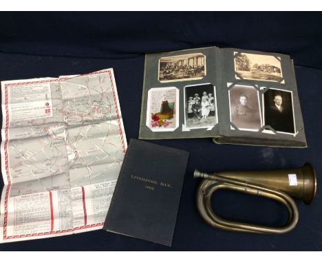
Lot 3309
A collector's lot to include: 1. 1937 Coronation (Edward VIII) leaflet for London transport arrangements (Bus, Underground, Tram, Cars & Taxicabs)2. Liverpool Bay 1925, bound map issued by Marine Surveyor & Water Baliff Drawing Office3. early 20th Century album with dedication dated May 10th 1920 containing a large collection of photographs, postcards - military, topographical, birthday, Sweetheart, animals etc 4. early 20th Century brass bugle (4)
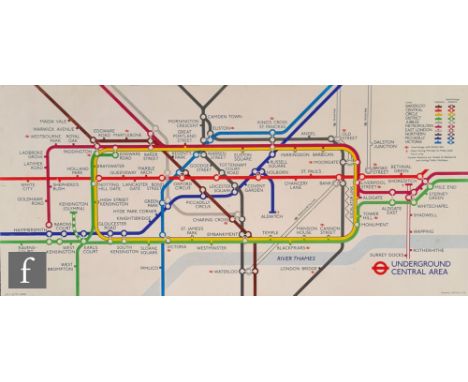
Lot 962
Four 1970s London Underground tube carriage rectangular advertising boards comprising an Underground Central Area map, Smirnoff Vodka, Contac 400 and London Zoo, all 27.8cm x 61cm, together with four Golden Wonder Salted Peanuts posters, 50.5cm x 34cm, and a large Guinness Battle of Hastings 1066 poster, 152cm x 101cm. (qty)


Lot 391
Thomas Walter Wilson (1851-1912) - Jilted - study in black crayon with red and white highlights of a Dutch boy wearing clogs, signed lower right, titled upper left, 46cm x 30cm, glazed frame, along with a 19th century ink, pencil and bodycolour coastal scene attributed to H.B.Carter 1807-1867, depicting Tynemouth Priory and Lighthouse circa 1851, inscribed to verso, a small map of Cumberland and Westmorland by Bowen & Bowen, an 18th century coloured print depicting a view of the Royal Palace of Hampton Court, published Aug 20 1760, in later frame, and an F. Bartolozzi print after Guercino, all in glazed frames (5)

Lot 489
WW2 German Luftwaffe Ace Gunther Rall Signed 12 x 8 inch Map of Occupied Europe. Signed in pencil. Had a Fold down the middle. Good condition. All autographs come with a Certificate of Authenticity. We combine postage on multiple winning lots and can ship worldwide. UK postage from £5.99, EU from £7.99, Rest of World from £9.99
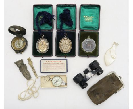
Lot 413
Two cased Hamilton Academy dux medals, both presented to Archibald Wilson for the 1905-06 session, one in Mathematics by Peter Ewen Esq., the other in Science Cristopher Crawford M.D.; a Robert Burns Dumfries Centenary commemorative medal by Pinches, London; a WW1 1918-dated military compass by S. Mordan & Co.; a Pathfinder combined compass-map measure, two carved lava Pompeii souvenirs etc. Condition Report:Available upon request


![[White (William) HISTORY, GAZETEER AND DIRECTORY OF NOTTINGHAMSHIRE], contemporary ownership inscription laid-down on front p](https://cdn.globalauctionplatform.com/3ad206d3-82a0-475f-96c8-afa401173d55/2797b930-de8b-40ef-8274-afa500a29cc4/468x382.jpg)
Lot 278
[White (William) HISTORY, GAZETEER AND DIRECTORY OF NOTTINGHAMSHIRE], contemporary ownership inscription laid-down on front pastedown, contemporary calf, rebacked and recornered, 8vo [Sheffield], 1853; .- A PICTORIAL AND DESCRIPTIVE GUIDE OF NOTTINGHAM... folding engraved map, publisher's limp wrappers, 8vo, n.d. (2) NB. We have specific instructions to sell this lot WITHOUT RESERVE.


Lot 1
Evans (Edward). South With Scott, London: Collins, circa 1942, 27 monochrome illustrations, folding map to the rear endpapers, period inscription to the front endpaper, some light toning, original cloth, 8vo, together with:Barber (Noel), The White Desert, 1st edition, London: Hodder and Stoughton, 1958, monochrome illustrations, period inscription to the front endpaper, some light marginal toning, original cloth in price-clipped dust jacket, covers rubbed with some teas & loss, 8vo, plusMundell (Frank), Stories of North Pole Adventure, London: The Sunday School Union, circa 1896, etched illustrations, bookplate to the front pastedown, pp.81-96 partially detached, some wear & toning, original illustrated cloth, boards & spine slightly marked & rubbed, 8vo, and other modern Polar exploration reference & related, all original cloth, some in dust jackets, 8voQTY: (33)
Lot 12
Green (William). The Tourist's New Guide, containing a Description of the Lakes, Mountains, and Scenery, in Cumberland, Westmorland, and Lancashire, 2 volumes, Kendal: R. Lough and Co., 1819, engraved folding map, 12 aquatint plates only, occasional light spotting, Spellow Hill book label to upper pastedowns, contemporary half calf, rebacked with gilt decorated spines, light wear to extremities, 8voQTY: (2)NOTE:Abbey Scenery 190.Abbey's copy contained 31 plates, but other examples have been found with 36 plates.Sold not subject to return.
Lot 149
Burnet (Gilbert). History of his Own Time, 1st edition, 2 volumes, London: Thomas Ward, 1724-34, woodcut printer's device to titles, extensive 18th-century annotations to front blank of volume 2, contemporary Cambridge panelled calf gilt, morocco title labels, some wear, 4to, together with:Dolby (Richard). The Cook's Dictionary, and House-Keeper's Dictionary, London: Henry Colburn, 1830, spotting, original maroon paper boards, worn, joints split, 8vo, withEarnshaw (Christopher). A Concise New Gazeteer of the World, Derby: H. Mozley, 1824, half-title, folding engraved map frontispiece, 6 folding engraved maps, lightly toned & spotted, contemporary calf gilt, joints cracked, rubbed, 8vo, with 23 other volumes, mostly antiquarian QTY: (27)
Lot 160
Medals. A Series of Drawings of the Orders of Knighthood, together with the Batons and Medals, conferred upon His Grace the Duke of Wellington, circa 1852, chromolithographed frontispiece arms of the Duke of Wellington and 35 plates, explanation letterpress ff. opposite each plate, lacking printed title and 2 explanatory leaves, spotting, contemporary black morocco gilt, red morocco label to front cover, all edges gilt, some wear, oblong 4to, together with:Waterloo. Souvenirs De Waterloo, [1842], 12 lithographs with hand-colouring, lacking folding plan, lightly dust-soiled, original paper wrappers, rebacked, oblong 8vo, in later custom green cloth case, withKelly (Christopher). The Memorable Battle of Waterloo, London: Thomas Kelly, 1817, engraved frontispiece & title, engraved plates throughout, engraved folding map, armorial bookplate of Philip S Henry to front pastedown, spotted, later burgundy half calf gilt, rubbed, 4to, with a carton of other volumes on the Napoleonic WarsQTY: (1 carton)
Lot 18
Taunt (Henry W.) A New Map of the River Thames, 3rd edition, Oxford: Henry W. Taunt, [1879], 33 double-page leaves of map sections, ecah with mounted woodbury type photographs, advertisements front and rear, occasional light spotting and toning, original cloth gilt, small split at head of spine, 8vo, together with Griffith (J.K.) A General Cheltenham Guide, Cheltenham: printed at the Chronicle Office, [1818], folding frontispiece and map, half title, engraved plates, some light offsetting and spotting, original wrappers, some wear to spine, modern cloth solander box, 8voQTY: (2)
Lot 2
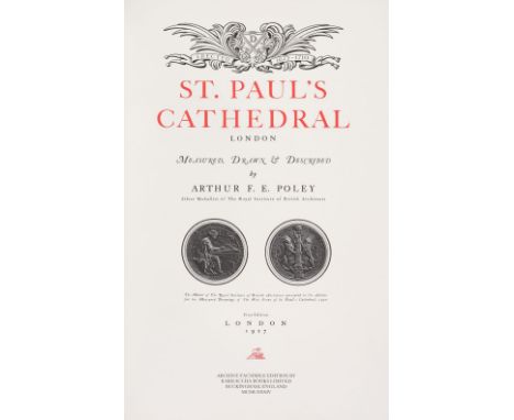
Facsimile Atlas. Ptolemy (Claudio), Geographia Ptolemaeus Auctus Restitutus Emaculatus, cum tabulis veteribus ac nobis, West of England Press Ltd. Tavistock, 1975, printed title and introduction, 47 double-page uncoloured maps, limited edition 61/250, signed by the Lord Mayor of Plymouth, publisher's morocco gilt, folio, contained in the publisher's red cloth slipcase, together with Rocque (John). An Exact Survey of the Cities of London and Westminster, The Borough of Southwark..., Harry Margary, Lympne Castle, Kent, 1971, double-page title and introduction by James Howgego, 41 uncoloured double-page maps, publisher's red cloth, with title label to the upper siding, folio, plus a separately bound index, with Morgan (William). London &c. Actually Surveyed and a Prospect of London and Westminster..., Harry Margary, Lympne Castle, Kent, in Association with the Guildhall Library, 1977, double-page title and introduction by Ralph Hyde, 12 uncoloured double-page maps, publisher's red cloth, with title label to the upper siding, folio, with Ogilby (John). A Large and Accurate Map of the City of London..., Harry Margary, Lympne Castle, Kent, in Association with the Guildhall Library, 1976, double-page title and introduction by Ralph Hyde, 21 uncoloured double-page maps, publisher's red cloth, with title label to the upper siding, folio, plus Stanford (Edward). Stanford's Library Map of London and its Suburbs, Harry Margary, Lympne Castle, Kent, in Association with the Guildhall Library, 1980, calligraphic title, introduction by Ralph Hyde, key plate and 24 uncoloured map sheets, publisher's red cloth, with title label to the upper siding, oblong folio, with another unbound copy, loose and rolled, and Poley (Arthur F. E.). St. Paul's Cathedral London, Measured, Drawn & Described, Archive facsimile edition, Barracuda Books, 1984, black & white plates and plans, limited edition, number 58, top edge gilt, publisher's half morocco gilt, slight dust soiling to the boards, large folio, together with:Cellarius (C.). Geographia Antiqua: Being a Complete Set of Maps of Antient Geography..., C & J Rivington, Longman, Hurst, Rees, Orme, Brown and Green, 1824, double-page calligraphic title page, contents list, 33 (complete as list) uncoloured double-page maps engraved by R. W. Seale and W. H. Toms, very slight spotting, near contemporary ownership signature to the verso of the title page, later endpapers, modern half calf gilt, 4to, plus:The Times Atlas. 1896, title and index, 116 colour printed lithographic maps (complete as list), index bound at rear, presentation inscription to the rear of the front endpaper, all edges gilt, contemporary half morocco gilt, worn and frayed, folio, George Philip & Son Ltd (publishers). Philips' International Atlas, 1931, title, preface and contents list, double-page frontispiece of the flags of all nations, 158 maps (complete as list) index bound at rear, presentation inscription to the front endpaper, contemporary cloth with gilt title to upper siding, spine faded, folio, with Ordnance Survey Office (publishers). Ordnance Survey Atlas of England & Wales, 1922, printed title, 24 double-page colour lithographic maps, laid on linen, index bound at rear, bookplate of the Flyfishers' Club, pastedowns stained, hinges and joints broken, preliminaries and first few leaves detached, text block and boards near detached, lacking spine, heavily worn and frayed, oblong folio, plus Yriarte (Charles). Venise. Histoire - Art - Industrie - La Ville - La Vu, Paris, 1878, additional half-title, numerous wood engravings throughout, top edge gilt, contemporary half morocco gilt, worn and frayed at extremities, spine faded, folioQTY: (13)
Lot 258
Williams (Edward Thomas). China, Yesterday and Today, 1st edition, New York: Thomas Y. Crowell, 1923, folding map to the rear board pocket, numerous monochrome illustrations, some light toning, original green cloth, boards & spine lightly marked & rubbed, 8vo, together with:Treves (Frederick), The Rivera of the Corniche Road, new edition, London: Cassell, 1923, 16 monochrome illustrations, frontispiece detached, period inscription to the front endpaper, some light spotting & toning, original green cloth, boards & spine lightly rubbed, 8vo, plus Morse (Hosea Ballou), The Trade and Administration of the Chinese Empire, 1st edition, Shanghai: Kelly and Walsh, 1908, folding map frontispiece plus a further folding map & 16 monochrome illustrations, some marginal toning throughout, original gilt decorated blue cloth, spine lightly faded, boards & spine lightly rubbed to head & foot, 8vo, and other modern travel reference, including travel guides & China related,mostly original cloth, many in dust jackets, G, 8voQTY: (6 shelves)

Lot 279
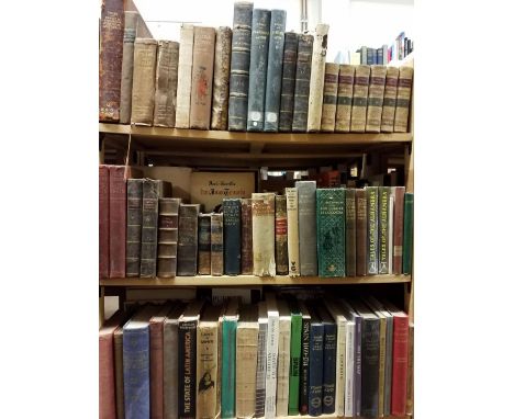
Hardy (Thomas). Far From The Madding Crowd, London: Osgood, McIlvaine and Co., 1895, etching frontispiece, map of Wessex to the rear, some toning & light wear, later endpapers, rebound retaining original gilt decorated green cloth boards & spine, spine slightly rubbed, 8vo, plus other works by Thomas Hardy, together with:Harris (Stanley), Old Coaching Days, London: Richard Bentley & Son, 1882, 12 illustrations by John Sturgess, some light spotting & toning, original illustrated brown cloth, spine slightly rubbed to head & foot, 8vo, plus other miscellaneous literature, including publications from the New Naturalist series, mostly original cloth, some in dust jackets, G/VG, 8vo/4toQTY: (3 shelves)
![* Belgium. Ortelius (Abraham), Leodiensis Dioecesis Typus, [1595 or later], engraved map with contemporary hand colouring, el](https://cdn.globalauctionplatform.com/09e586ed-2205-489f-8ff5-afa100a0834b/10a5cbd1-2b86-412b-aa3c-afa200c9a68c/468x382.jpg)
Lot 291
McLeod (John). Voyage of His Majesty's Ship Alceste, to China, Corea, and the Island of Lewchew, with an account of Her shipwreck, 3rd edition, London: John Murray, 1820, portrait frontispiece, folding map, 5 hand-coloured plates, bookplate to the front pastedown, some minor toning, contemporary green half morocco, spine slightly faded, boards & spine lightly rubbed, 8vo, together with:Kent (Samuel), The Grammar of Heraldry..., London: printed for J. Pemberton, 1716, etched examples of heraldic shields, period inscriptions to the front endpaper & title page, book plate to the front pastedown, some light wear & marks, contemporary embossed full calf, some loss to the front board, slightly rubbed, 8vo, plusMilton (John), The Poetical Works of Mr. John Milton, volume 1 only, London: printed for Jacob Tonson, 1720, engraved portrait frontispiece plus title vignettes, bookplate to the front pastedown, some light toning, spotting & offsetting, later endpapers, all edges gilt, 19th-century gilt decorated full calf, boards & spine lightly rubbed, large 4to, and other 18th & 19th-century literature, mostly contemporary leather bindings, some odd volumes & French language, overall condition is generally good/very good, 8vo/4to59 volumesQTY: (3 shelves)
Lot 292
Twiss (Richard). Travels through Portugal and Spain, in 1772 & 1773, 1st edition, London: printed for the Author, 1775, lacks folding engraved map and all plates, half-title and preliminary leaves near detached, several embossed library stamps and some old damp staining to upper margins, Roan-backed cloth with library labels and gilt stamps, worn, 4to, together with Ford (Richard). A Handbook for Travellers in Spain, parts I & II, 3rd editions, London: John Murray, 1855, first volume lacks folding map from pocket at rear, folding map of Andalucia present but with some worming, some spotting throughout, early name inscription written vertically to title of first volume, armorial bookplate of John Hay to second volume, original cloth gilt, soiled, spines chipped and frayed, small 8vo, plus Society for the Diffusion of Useful Knowledge, The History of Spain and Portugal, London: Baldwin and Cradock, 1833, hinges cracked, original cloth, rubbed and soiled, upper joint partly split, 8vo, plus other mostly cloth-bound 20th-century Hispanic interest QTY: (6 shelves)
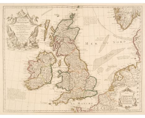
Lot 31
British Isles. De L'Isle (Guillaume), Les Isles Britanniques ou sont le Rme. d'Angleterre tiré de Sped celuy d'Ecosse tiré de Th. Pont &c. et celuy d'Irlande tire de Petti..., Paris, 1702, engraved map with contemporary outline colouring, large uncoloured allegorical cartouche and mileage scale, 475 x 620 mm, together with De Vaugondy (Robert). Britannicae Insulae Tribus modis distinctae..., Paris, circa 1750, engraved historical map with contemporary outline colouring, 410 x 535 mm, with another copy similarQTY: (3)NOTE:R. W. Shirley. Printed Maps of the British Isles, 1650 - 1750. De L'Isle 1 state 5. The second item is not recorded in Shirley.

Lot 32
Cornwall. Rundell (William Westcott), Cornwall, W. Wood, Falmouth, circa 1850, uncoloured engraved folding map, printed in blue and laid on linen, inset map of the Scilly Isles, some staining and dust soiling, slight wear where old folds cross, 345 x 420 mm, contained in contemporary red cloth boards with publisher's printed label to the upper cover, upper board near detachedQTY: (1)NOTE:A rare map of Cornwall found in Wood's The Stranger's Hand-Book to Cornwall published in 1855, and in John Thomas Blight's Hand-Book to Cornwall, circa 1860. We can find no record of the map appearing separately and William Rundell does not appear in Worms and Baynton Williams British Map Engravers.


Lot 34
* Egypt. Homann (Johann Baptist). Aegyptus Hodierna, Nuremberg, circa 1720, engraved map with bright contemporary hand-colouring, slight staining to left-hand margin, 585 x 490 mm, mounted, framed and glazed with perspex, together with Le Kaire. Vue de la Place Appellée el Roumeyleii et de la Citadelle, originally published in 'Description de L'Egypte...' Paris [1809 - 29], hand-coloured engraved prospect of the city of Cairo, slight spotting and creasing, occasional repaired closed tears, 440 x 900 mm, mounted, framed and glazed in perspexQTY: (2)

Lot 36
England & Wales. Phillips (M.), The Grand Southern Tour of England including the Principal part of the East, West & Inland Counties, Patronised by Her Majesty the Queen, His Royal Highness the Prince Regent..., pub. J. Hebner, c.1820, large engraved map with contemporary hand colouring, dissected and mounted on linen in forty-eight sections, extending north to south from Northampton to the Isle of White and west to east from Taunton to Aldborough, calligraphic cartouche, slight staining and dust soiling, 1010 x 1790 mm, together with Cooper (J.). Map of England, Wales and the Southern part of Scotland, W. P. Metchim, 1849, lithographic map with contemporary wash colouring, sectionalised and laid on linen, some dust soiling, 790 x 640 mm, marbled endpaper, bound in contemporary cloth boards with publisher's printed label to the upper cover, boards and spine, worn, faded and bumped, QTY: (2)

Lot 37
Folding Maps. Greenwood (C. & J.), Map of the County of Warwick from actual Survey, made in the years 1820 & 1821, Dedicated to the Nobility, Clergy & Gentry of the County by the Proprietors and Published for them by George Pringle Junr. C. & J. Greenwood..., 1822, large-scale engraved map with contemporary wash colouring, sectionalised and laid on linen, calligraphic title, table of explanation, compass rose and uncoloured vignette of Warwick castle, stained and toned, occasional splits along old linen, slight wear causing small holes where old folds cross, the map edged in blue silk, 1320 x 1050 mm, together with Kitchin (Thomas). A New Improved map of Oxfordshire from the Best Surveys and Intelligences..., J & C Bowles & Robert Sayer, circa 1767, engraved map with contemporary outline colouring, sectionalised and laid on linen, large uncoloured cartouche, some overall dust soiling, 715 x 525 mm, with Hodskinson (Joseph). The County of Suffolk, reduced from the large map in Six Sheets..., William Faden, Jany. 1st. 1787, engraved map with contemporary wash colouring, sectionalised and laid on linen, toned and stained overall, some marginal fraying with slight loss to the printed surface, slight insect damage, 585 x 780 mm, plus Bowen (Emanuel). An Accurate Map of the Counties of Leicester and Rutland, Divided into Hundreds..., circa 1767, engraved map with contemporary outline colouring, sectionalised and laid on linen, large uncoloured cartouche, some overall dust soiling, small holes where old folds cross, margins painted black, 550 x 690 mm, contained in a contemporary marbled card slipcase, worn and frayed, and Cary (John). A New Map of Derbyshire, Divided into Hundreds Exhibiting its Roads, Rivers, Parks &c. 1823, engraved map with contemporary wash colouring, sectionalised and laid on linen, some dust soiling and slight staining, 550 x 485 mm, marbled endpapers, with another 20 maps similar, including examples by or after Ordnance Survey, Bartholomew, Smith, Wyld, Cruchley, Geographia, Couchman, Bailey and Morden, various sizes and condition QTY: (26)

Lot 39
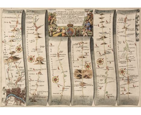
* London Railways. Betts (J. C.), Railways of London, Waterlow & Sons Limited, Dunstable & Watford, winter 1924/25 issue, colour lithographic map of the underground and mainline railways of London, reference tables and additional information printed below the map and in the margins, old folds, 330 x 440 mm, framed and glazedQTY: (1)NOTE:Dodd. Maps of London Transport, page 102.
Lot 40
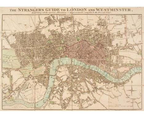
London. Mogg (Edward). The Strangers Guide to London and Westminster, Exhibiting all the various Alterations & Improvements to the Present Time, Jany. 1st 1811, engraved map with contemporary wash colouring, sectionalised and laid on linen, 410 x 570 mm, contained in a contemporary card slipcase with publisher's printed labels to both sidings and an old auction lot label to the upper cover, slight wear t the extremities of the slipcase, together with Aikin (John). The History of the Environs of London..., John Stockdale, 1811, title page with old ink library stamp, five uncoloured engraved county maps by J. Stockdale, one folding engraved map of the course of the River Thames with ink library stamp to recto, one single sheet map and fifteen uncoloured topographical plates, library stamps to the verso of some plates and maps, later endpapers with old library adhesions and stamps, modern cloth binding, 4to, with Bacon (G. W. & Co. Ltd. publishers). Bacon's Library Map of the Environs of London, circa 1920, large colour lithographic map, sectionalised and laid on linen, 960 x 1445 mm, marbled endpapers with old library stamps to the verso, contained in a contemporary cloth slipcase with gilt title and crude additional manuscript (pencil) annotations to the upper cover, plus Booth (Charles). Labour and Life of the People, Appendix to volume 2, Williams and Northgate, 1891, appendix and tables with a loose folding colour lithographic map "Map Shewing Degrees of Poverty in London in Areas with about 30,000 Inhabitants in each Compiled from Information collected in 1889 - 1890", the whole laid on linen, toned overall, split and worn along old folds, 635 x 865 mm, publisher's cloth, worn at extremities, boards marked and scuffed, spine toned, 8vo QTY: (4)NOTE:The first described item. Howgego, The Printed Maps of London, number 238, state 4. Sold as a collection of maps and prints, not subject to return.

Lot 41
London. Walker (J & C), A Plan of London and its Environs, circa 1830, hand-coloured engraved map, originally published in 'Lewis's Topographical Dictionary', repaired marginal closed tears, old folds, laid on to later paper, 410 x 500 mm, mounted, together with De Fer (Nicolas). Plan des Villes de Londres et de Westminster..., 1700, hand-coloured map engraved by C. Inselin, 230 x 340 mm, mounted, framed and glazed QTY: (2)
Lot 43
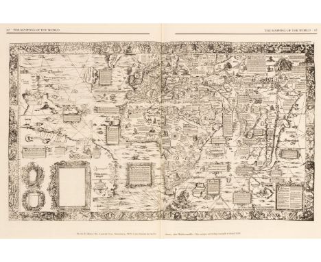
Map Reference & Facsimile Atlases. A collection of 30 volumes, mostly 20th-century, including Shirley (Rodney W.). The Mapping of the World, Early Printed World Maps, 1472 - 1700, The Holland Press, 1983, additional half-title, numerous colour and black and white illustrations throughout, publisher's cloth gilt, dust jacket, folio, together with Dekker (Elly). Globes at Greenwich. A Catalogue of the Globes and Armillary Spheres in the National Maritime Museum, Greenwich, Oxford University Press and the National Maritime Museum, 1999, additional half-title, numerous colour and black and white illustrations throughout, publisher's cloth gilt, dust jacket, folio, contained in a contemporary card slipcase, with Burden (Philip D.). The Mapping of North America. A List of Printed Maps 1511 - 1670, Raleigh Publications, 1996, additional half-title (signed by the author), numerous colour and black and white illustrations throughout, publisher's cloth gilt, dust jacket, folio, plus other reference books including Joan Blaeu's Atlas Major in two volumes published by Taschen, folio, and volumes by Hyde, Howgego, Skelton, Baynton-Willimas and Barron, with Stanford (Edward, publisher). The Ordnance Survey Atlas of England and Wales, circa 1920, printed title, tipped in errata slip, 24 double-page colour lithographic maps, laid on linen, index bound at rear, bound with The Ordnance Survey Atlas of Scotland, printed title, tipped in errata slip, 18 double-page colour lithographic maps, laid on linen, index bound at rear, publisher's cloth gilt, oblong folio, and Bartholomew (John & Co. publisher). Plan of the City of Edinburgh with Leith and Suburbs, 1891, 12 folding colour lithographic maps, several crudely repaired long closed tears throughout, publisher's cloth gilt, worn, slim upright folio, with others similarQTY: (30)
Lot 44
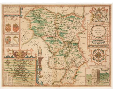
Maps. A collection of approximately 200 maps, 17th - 19th century, including Speed (John). Anno Darbieshire described, Thomas Bassett & Richard Chiswell [1676], hand coloured engraved map, inset town plan of Derby and vignette of Buxton, strapwork cartouche, compass rose and mileage scale, short split at head of central fold, slight staining and spotting, small margins, 390 x 515 mm, English text on verso, together with another approximately 200 county maps, road maps and town plans, with examples by or after Lewis, Langenes, Luffmann, Blome, Kitchin, Moule, Laurie & Whittle, Hall, Morden, Conder, J & C Walker, Carey, Pigot, Seller/Grose, Weller and Von Reilley, occasional duplicates, various sizes and condition. QTY: (approx. 200)
![* Maps. Saxton (Christopher & Hole G.), Glocestriae comitatus olim sedes Dobunorum [1627], hand-coloured engraved map, la](https://cdn.globalauctionplatform.com/09e586ed-2205-489f-8ff5-afa100a0834b/8c567a23-f952-4ad5-8a39-afa200c9ba46/468x382.jpg)
Lot 46
* Maps. Saxton (Christopher & Hole G.), Glocestriae comitatus olim sedes Dobunorum [1627], hand-coloured engraved map, large strapwork cartouche, mileage scale and compass rose, trimmed to the image along the lower margin, border extended, small area of loss, replaced in facsimile, 280 x 310 mm, mounted, framed and glazed, together with Mercator (Gerard). Anglia Regnum, circa 1600, engraved map with sparse potline colouring, large strapwork cartouche, toned overall, central fold repaired on verso with resultant staining, 350 x 470 mm, framed and double-glazed, French text on verso, with Morden (Robert). Wiltshire [1695 or later], hand-coloured engraved map, 340 x 405 mm, mounted, framed and glazed, plus Saxton (Christopher & Kip W.). Wiltoniae comitatus herbida Planicie nobilis vulgo Willshire pars olim Belgarum [1627], hand-coloured engraved map, strapwork cartouche, mileage scale and compass rose, thread margins, 275 x 345 mm, framed and glazed, and Cary (John). A Map of Wiltshire from the best Authorities, 1805, hand-coloured engraved map, 520 x 405 mm, framed and glazed, together with Lea (Philip). Isle of Wight, Sussex, part of Wiltshire, Surrey and Kent, circa 1695, hand-coloured engraved map, trimmed to the neat line, some creasing, 280 x 425 mm, framed and glazed, with another eight British county, road, regional and town maps, including examples by or after Dawson, Moule, Pigot, Mercator and Carington Bowles, all framed and glazed, plus a Levasseur map of the 'Departement de L'Herault' 310 x 430, framed and glazedQTY: (14)
Lot 47
Maps. Smith (Charles). Smith's New Map of England and Wales and part of Scotland including the Turnpike and principal Cross Roads..., 1821, engraved map with contemporary outline colouring, sectionalised and laid on linen, calligraphic cartouche, compass rose, mileage scale and table of explanation, slight staining, marbled endpapers, 1145 x 940 mm, contained in a contemporary reverse calf slipcase with 'envelope style' lid, case heavily worn and rubbed, together with Cox (Thomas). A Topographical, Ecclesiastical and Natural History of [Surrey], circa 1720, folding uncoloured engraved map of Surrey by Robert Morden, map size 175 x 210 mm, 127 pages of descriptive text, modern endpapers, modern half calf over marbled boards, 4to, with Hinton (John, publisher). The Universal Magazine of Knowledge and Pleasure..., volume XL, 1767, engraved allegorical frontispiece, 7 engraved plates and three folding strip road maps, upper hinge and joint weak and cracked, contemporary calf, rubbed and worn, 8vo, plus Royal Commission on London Traffic (publishers). Report of the Royal Commission Appointed to Inquire Into and Report upon the Means of Locomotion and Transport in London, 1905, four large folding lithographic maps, descriptive text, publishers printed paper wrappers, lacking rear cover, upper cover frayed and torn with loss, folio, with another 12 folding maps, including examples by or after Ordnance Survey, Atkin & Co. Geographia, Walker and Brown & Co., various sizes and conditionQTY: (16)

Lot 49
National Geographic Society (publishers). The Reaches of New York City, Baltimore, 1939, large decorative lithographic map by Albert H. Bumstead, inset map of South Jersey, the margins decorated with portraits of prominent Americans, topographical vignettes and vistas, old folds, 705 x 645 mm, with another copy similar, together with Historic and Scenic Reaches of the Nation's Capital, National Geographic Society, 1938, large decorative lithographic map by C. E. Riddiford, the margins decorated with portraits of prominent Americans, topographical vignettes and vistas, old folds, 645 x 770 mm, with Gulf Oil Corporation (publishers). Florida, printed by Rand McNally and Co., circa 1955, decorative colour lithographic touring map, old folds, additional maps and advertisements to the verso, plus Arnold (Danny). Danny Arnold's Pictorial Map of The Old West, Showing Pioneer Trails and Battles, Indian's (sic) Territories, Stagecoach lines, Military Forts, Historical data of the Frontier period around 1840, Compiled and Illustrated by Fran Dowrie, printed in Ireland by Webbs, circa 1970, decorative colour printed tea towel on linen with the borders decorated with 26 portraits of well-known characters from the wild west, slight creasing, 470 x 745 mm, with a larger example (610 x 855 mm) printed on paper, and, Peterson (C. C. publisher). The United States at War, circa 1945, decorative colour photolithographic map of North America, inset map of 'The Ocean Fronts', several martial and maritime vignettes, old folds, the whole strengthened with tissue on the verso, additional black and white map of the eastern hemisphere on the verso, 500 x 665 mm, supplied with the contemporary publisher's envelopeQTY: (7)
Lot 51
Philip (George & Son, publishers). Philip's Handy General Atlas of America, 1879, title and index, 22 (of 23, lacking the map of Kansas) double-page colour lithographic maps, one map detached, upper joint weak and cracked, publisher's gilt cloth, worn and faded, small folio, together with Beers (J. B.). County Atlas of Middlesex Massachusetts..., New York, 1875, calligraphic title, 151 colour lithographic single page, double page and folding maps of town plans, regions and counties, some fraying, marginal chipping and staining throughout, text block detached, publisher's cloth gilt, spine partially lacking, crudely repaired with masking tape, bumped worn and rubbed, folio, with Walker (George H. & Co. publishers). Atlas of Massachusetts..., Boston, circa 1890, calligraphic title, numerous colour lithographic double-page maps, slight staining throughout, publisher's blind-stamped half morocco, boards detached, lacking spine, crude tape repairs to the spine, heavily worn and rubbed, folio, plus, Office of the Surveyor General, (publishers). Alberta and British Columbia Boundary Atlas, Part III from 1918 to 1924, Ottawa, 1925, title printed on the upper siding, index map and 29 colour photolithographic maps, a few maps with red crayon annotations, publisher's cloth gilt, slim folio, and [Garran, Hon. Andrew. Picturesque Atlas of Australasia, 2 volumes (only of 3) 1888], lacking titles and preliminaries, numerous illustrations and maps throughout, some leaves disbound, boards detached, heavily worn and rubbed, folioQTY: (6)NOTE:Sold as a collection of maps and prints, not subject to return.
-
109198 item(s)/page