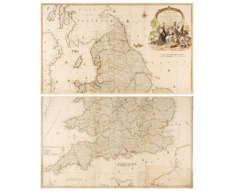
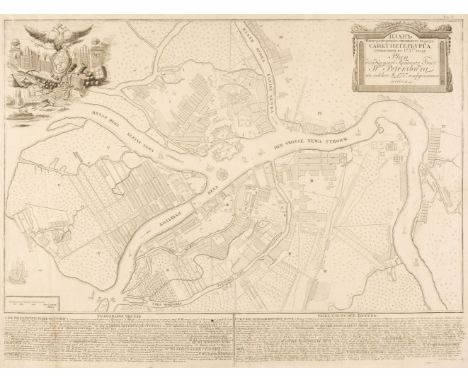
Wallis (James). Wallis's New Pocket Edition of the English Counties or Travellers Companion in which are carefully laid down all the Direct & Cross Roads, Cities, Townes, Villages, Parks, Seats and Rivers with a General Map of England & Wales, published J. Wallis and sold by Davies & Eldridge, Exeter, circa 1814, letterpress title and contents list, forty-two (of 43, lacking Leicestershire) engraved maps with contemporary hand colouring, including 1 double-page (Yorkshire), plus a small map of the Isle of Wight bound at rear, text block broken and cracked with some pages loose, blind-stamped address to the front endpaper, bookplate of Donald Hodson to the front pastedown, contemporary half morocco gilt with contrasting red morocco gilt title label to the upper siding, upper board near-detached, worn, rubbed and frayed, 12mo, together with Cary (John). Cary's Traveller's Companion or, A Delineation of the Turnpike Roads of England and Wales..., printed for G. & J. Cary, 1824, calligraphic title page, advertisement and contents list, 42 engraved maps (lacking Yorkshire) all with contemporary outline colouring, bound with Cary's New Itinerary: or an Accurate Delineation of the Great Roads Both Direct and Cross, throughout England and Wales..., 1812, calligraphic title and dedication, appears to lack the folding engraved map of England & Wales, seven regional engraved maps all with contemporary outline colouring, contemporary limp diced sheep in an 'envelope style' binding, heavily worn and frayed, 8vo, with Pinnock (W. editor). The Guide to Knowledge, volume 1 (only), W. Edwards, 1833, uncoloured lithographic portrait frontispiece of William IV, uncoloured engraved folding hemispheral map of the world, one engraved plate, six steel engraved maps (2 folding) and 43 wood-engraved (white on black) British county, foreign and city plans ( three folding and one double-page), a few maps frayed with slight loss, numerous wood-engraved plates and vignettes throughout, upper hinge cracked and weak, contemporary half morocco gilt, frayed and worn, 4to, plus Hall (Sidney). A Travelling Atlas of the English Counties, Chapman and Hall, circa 1860, title and contents list, 46 (complete as list) double-page lithographic maps with contemporary outline colouring four folding, gutta perch perished, contents shaken and loose, bookplate of Donald Hodson to the front pastedown, contemporary limp green morocco 'envelope style' binding, worn and frayed, with another copy similar, and [Aikin, John]. England Delineated; Or, A Geographical Description of Every County in England and Wales: with a concise account of its most important products, natural and artificial, for the use of young persons, 5th ed., considerably improved, 1803, double-page map of England and Wales and forty outline county maps, rear hinge split, bookplate of Donald Hodson to the front pastedown, contemporary half calf with gilt decorated spine, upper board detached, somewhat rubbed and worn, 8vo, with another ten atlases similar, including examples by or after Owen, Leigh, Pinnock and Gorton, various sizes and conditionQTY: (16)NOTE:Sold as a collection of maps, not subject to return


![Ireland. Speed (John), The Province of Mounster, Thomas Bassett & Richard Chiswell [1676], hand-coloured engraved map, in](https://cdn.globalauctionplatform.com/910db78b-cd1e-4760-a5d0-b0dc011def41/fe46d54e-9dff-4f10-8d23-b11e011e0e20/468x382.jpg)

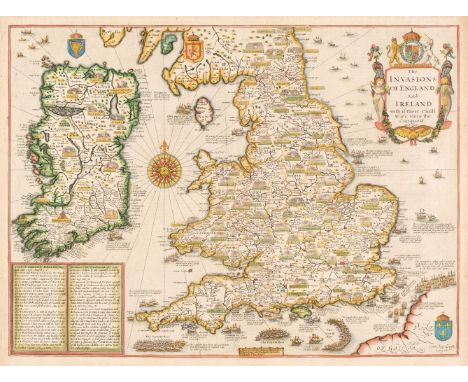
![British Isles. Ortelius (Abraham), Angliae, Scotiae et Hiberniae sive Britannicar: Insularum Descriptio [1610 - 12], engraved](https://cdn.globalauctionplatform.com/910db78b-cd1e-4760-a5d0-b0dc011def41/93275106-35f3-4e1c-bceb-b11e011ddb36/468x382.jpg)


![[Morris, Reginald O. & Sir Alexander Kaye Butterworth]. George Butterworth 1885-1916, printed for private circulation onl](https://cdn.globalauctionplatform.com/910db78b-cd1e-4760-a5d0-b0dc011def41/8123b00a-00c0-431b-be33-b11e011fd3fd/468x382.jpg)
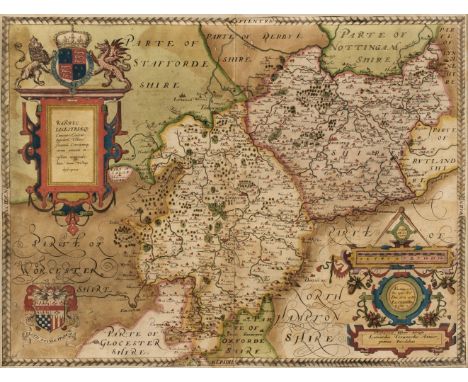


![Wales. Speed (John), Wales, Thomas Bassett & Richard Chiswell [1676], hand-coloured engraved map, twelve oval vignettes o](https://cdn.globalauctionplatform.com/910db78b-cd1e-4760-a5d0-b0dc011def41/6438494f-f2f8-4d1b-b5b0-b11e011e55ad/468x382.jpg)