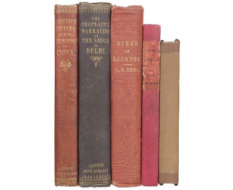

Robertson (Henry Dundas). District Duties during the Revolt in the North-West Provinces of India, in 1857: with remarks on subsequent investigations during 1858-59, 1st edition, London: Smith, Elder and Co., 1859, folding map, 24 pp. advertisements at end, occasional small annotations, press cutting at front listing A.H. Cocks to be made Order of the Bath for service in India, his signature, original blindstamped cloth, spine a little faded, 8vo, together with Rotton (John Edward Wharton). The Chaplain's Narrative of the Siege of Delhi. From the outbreak at Meerut to the capture of Delhi, 1st edition, London: Smith, Elder and Co., 1858, folding map, advertisements at rear, small offsetting from piece of newspaper to p. 96, bookplate, original cloth, some fading to spine, a little rubbed with light stains, 8vo, plus Rees (L.E. Ruutz). A Personal Narrative of the Siege of Lucknow. From its commencement to its relief by Sir Colin Campbell, 2nd edition, London: Longman, Brown, Green, Longmans & Roberts, 1858, portrait frontispiece, folding map, errata slip, occasional light spotting and offsetting, bookplate of William Slaney Kenyon Slaney (1847-1908, soldier, politician and sportsman), original cloth, slight fading to spine, small ink stains to upper cover, slight lean, 8vo, with 2 others: The Defence of Lucknow. A Diary... by a Staff Officer (i.e. Thomas Fourness Wilson), 1858, and A Lady's Diary of the Siege of Lucknow. Written for the perusal of friends at home, [by Mrs G. Harris], 1858 (rebound, lacking endpapers)QTY: (5)
We found 109198 price guide item(s) matching your search
There are 109198 lots that match your search criteria. Subscribe now to get instant access to the full price guide service.
Click here to subscribe- List
- Grid
-
109198 item(s)/page
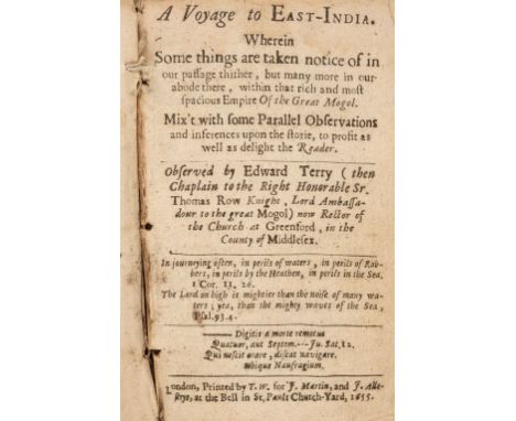
Terry (Edward). A Voyage to East-India. Wherein some things are taken notice of in our passage thither, but many more in our abode there, within that rich and most spacious Empire of the Great Mogol, 1st edition, London: printed by T.W. for J. Martin and J. Allestrye, 1655, 2 engraved plates only (detached, one lacking part of left side of image), lacking the portrait frontispiece, map and folding plate, stitching breaking, some leaves detaching, some light spotting and soiling, hinges broken, contemporary sheep, part of upper cover fore edge frayed, some wear to corners, 8voQTY: (1)NOTE:Wing T782. Edward Terry (1590-1660) served as chaplain to Sir Thomas Roe, ambassador to the Mughal Court from 1617-18, his observations of the Empire and its inhabitants was first published in 1625 in Purchas his Pilgrimes, the present edition greatly expanded by the author. Sold with all faults not subject to return.
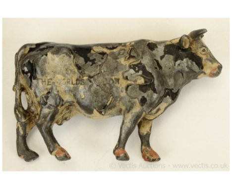
Britains - Map of the World Cow, Second Version, comprising: Friesian Cow with Black Markings forming a World Map along its Flanks, made as a Nestle` s Milk promotional item in 1924 for the British Empire Exhibition. This second version example has the wording "Nestles Milk" & "The World Cow" cast onto its Flanks. Extensive paint losses otherwise generally Poor overall.

The Pedestrian's Companion, 15 Miles round London, Published by M.J Godwin & Co, 1822, hand coloured, the map flanked by a good list of market towns within 15 miles radius of London, dissected and laid down on linen, with previous owner's name and date to the outside 'Edward Quillinan, London February 18. 1824, complete with cardboard sleeve with retailer's label, also with previous owners initials and annotation
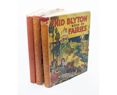
Blyton, Enid. The Enid Blyton Book of Bunnies; The Book of Fairies; The Book of Brownies, the last two in dustwrappers, illustrated by K Nixon, Ernest Aris and Lola Onslow with map drawn by E B, published by G Newnes, c. 1930-4, several line illustrations prettily coloured in, inscription to the “Fairies” on endpaper dated 1934, illustrated paper boards, 4to. (3)


HOORN -- NEPOS, C. Vitae excellentium imperatorum, (…). Nec non excerptis P. Danielis. Index studio & opera J.A. Bosii. Suas notas addidit A. v. Staveren. Ed. 2a. Leyden, 1773. W. front., ti-engr. & small engr. portrs. in the text. Cont. full cf. w. raised bands, dec. gilt back, red label, gilt coat of arms of Hoorn on both sides, surrounded by gilt borders. Copy w. school prize for Rudolphus Jacobus Koning 1819. -- Added: D. RUHNKENIUS. Elogium T. Hemsterhusii. Acced. Vita D. Ruhnkenii, auct. D. Wyttenbach. Cum praef. et annot. ed. J.T. Bergman. Leyden, 1824. Cont. vellum w. dec. gilt back, gilt coat of arms of The Hague on both sides. -- FLORUS. Epitome rerum Romanarum. Cum integris Salmasii, Freinshemii, Graevii. Ed. 2a. Leiden, 1744. W. engr. front. & 1 fold. engr. map of the ancient world. Cont. cf. w. raised bands, dec. gilt back & red label. -- JANUS SECUNDUS. Opera. Acc. rec. ex museo P. Scriverii. Leyden, F. Hegerus, 1631. W. engr. ti. & engr. portr. of the author. 12°. Cont. vellum w. overl. sides. -- (4).
BIBLIA NEERLANDICA -- BIBLIA, Dat is de gantsche H. Schrifture, vervattende alle de Canonijcke Boecken des O. en des N. Testaments. Dordr., (etc.), J. & H. Keur, 1741. 4 parts in 1 vol. W. engr. ti. and 6 engr. fold. plates, incl. a fine map of the world by J. v. Jagen (300 x 460 mm). Fol. Cont. blind tooled cf. over wooden boards, brass bosses (5) to each side, brass clasps and catches. (Spine renewed, clasps w. new leather hinges, new endpapers, some small rep. to text in places, age-toned/browned throughout, but in v.g. condition).

BIBLIA NEERLANDICA -- (MARTIN, D.). Historie des Ouden en Nieuwen Testaments. (Vert. d. W. Séwel). Amst., P. Mortier, 1700. 2 vols. (18), 282, (8); (26), 163, (11) pp. W. 2 variant engr. fronts., lge. engr. vign. on each ti., 32 engr. head- & tailpieces, 5 engr. double-p. maps (incl. a world map & 3 indexes) & w. c. 428 illustrations on 214 engr. plates. Lge-fol. Cont. hcf. w. raised bands, dec. gilt backs & brown labels. (Lower & upper compartment spine vol. 1 dam./partly gone, corners/edges a bit worn, sides a bit rubbed, a few marg. repairs/thumbs, but a clean set with strong impressions). NOTE: So-called 'Grote bijbel van Mortier'. One of the finest illustrated bibles produced in the Netherlands with engravings after Luyken, Picart/d, Goeree, Tideman, Hoet by Baptist, Blois, Mulder a.o. On this luxurious bible cf. Van Eeghen/v.d. Kellen 351; Klaversma/Hannema 180, 187; Poortman II, 98-105.

BOEY, Th. De oudheid van den Hove van Holland nader onderzogt, en uit de oppermagt der staaten met den grave, verder beweezen. The Hague, 1761. 4º. Mod. h. vellum extra w. marbled sides. (Slight yellowing in the textblock, otherwise a good & sound copy). -- C. ROGGE. Tafereel van de geschied. der jongste omwenteling in de Ver. Nederlanden. Amst., 1796. W. 1 lge-fold. cont. handcold. map of the 'Bataafse Republiek', 4 fold. plates, 1 full-p. plate & 1 fold. tab. Later hcf. w. spine raised in bands & dec. in gilt w. green labels. (Spines & sides scuffed, wear to extremities). -- P. de la RUË. Staatkundig en heldhaftig Zeeland. Middelb., 1736. 4°. Cont. vellum. (Some stamps on title-p.). -- And 5 o. (8).

(CHRISTYN, J.B.). Histoire générale des Pais-Bas, Contenant la Description des XVII provinces. Brux., F. Foppens, 1720. 4 vols. W. 4 engr. fronts., 1 engr. fold. map, & 143 engr. plates/plans, for the greater part fold. Cont. cf. w. gilt backs raised in 6 compartments. (Binds. rubbed/chafed, lower joint vol. 1 split, extremities worn/dam., 1 plate with part torn off (missing)). NOTE: This work is generally ascribed to the jurist Johannes-Baptista Christyn (1659-1707) allthough this is not certain (cf. NNBW VI, 99). - Rare.

ZEELAND -- GARGON, M. Walchersche Arkadia. 2e-3e dr. Leyden, Luchtmans, 1746. 2 vols. (18), 318, (14); (16), 369, (25) pp. W. 2 identical fronts., 2 fold. maps, 17 full-p. engr. & 5 fold. plans/engr. (1 on shipbuilding). Sm-8°. Cont. cf. w. richly dec. spine raised in compartments. (Wear to extremities & traces of use, small name stamp on title-p., 1 fold. map torn at attachment point, but alltogether a nice, complete set). NOTE: Interesting work, contains many details on the early history of Zeeland and also ample descriptions of the Nehallennia statues. - Nijhoff/v. Hattum 103; Haitsma Mulier/v.d. Lem 178 a; Nagtglas I, 245-249.

ZEELAND -- (SMALLEGANGE, M.). Beschryvinge van den Zeelandschen adel. (Middelburg, c. 1700). 6 lvs. of text (printed on r° side only), & 6 broadsheets w. coats of arms. (Images c. 320 x 415 mm). (Text lvs. somewhat browned, all lvs. worn at extremities, some smudging, does not affect text or image). NOTE: Usually bound up with the 'Nieuwe Cronyk van Zeeland'. The plates can also be put together to form one large heraldic map according to a fixed scheme.

ZEELAND -- SMALLEGANGE, M. Nieuwe Cronyk van Zeeland, Dl. 1 (=all publ.). Middelburg, J. Meertens & A. v. Someren, 1696 (=1700). (10), 774, 12, (12) pp. W. engr. front. by Mulder, engr. vign. on ti. (coat of arms), 1 engr. headpiece, 1 map in the text, 3 double-p. maps (1 lge-fold.), 73 double-p./fold. plans & views, 8 full-p. engr. & 6 heraldic double-p. plates to 'Beschryving v.d. Zeelandschen adel'. Fol. Cont. cf., spine raised in compartments, traces of ties. (Spine & hinges dam., corners have been repaired, in a few places the boards are visible, or. endpapers have been replaced, a few tiny wormholes in the margins, several maps slightly torn along the fold, plt. 422-3 loosely inserted, plt. 529-1: one lf. cleanly detached, still a good complete copy). NOTE: The most extensive description of Zeeland based on the chronicles by Eyndius and Reygersberch. The 'Nieuwe Cronyk van Zeeland' remained unfinished due to disagreements between the towns of Zeeland regarding its content. The genesis of this sumptuous chronicle took more than 30 years! - Cf. at length Verkruijsse, Mattheus Smallegange (1624-1710): Zeeuws historicus, Genealoog en Vertaler, 1983, p. 343-400; Nijhoff/v. Hattum 282; Haitsma Mulier/v.d. Lem 445d.

SURINAM -- STEDMAN, J. Voyage à Surinam et dans l'Intérieur de La Guiane, (…). Avec des détails sur les Indiens de la Guiane et les Nègres. Paris, An VII (1799). 44 engr. maps (of which 5 fold.), views and plates. 4º. Old binding. (Front side detached, plts. show some yellowing, (dust-)stains & tears, the tear at the bottom of map V runs into image). NOTE: Complete copy of the atlas vol., without the text vols. - Sold w.a.f., not subject to return.

ATLASES -- LETH, H. de. Nieuwe Geographische en Historische Atlas, v.d. Zeven Vereen. Ned. Provintien. Amst., H. de Leth, (1766). 156, (4) pp. of text preceded by a fold. engr. ti. dec. w. 8 plain coats of arms, 35 engr. maps all in cont. handcolouring, 14 plain fold. engr. depicting town plans, and 2 cold. fold. distance tables. Bind. renewed, but margins not trimmed. (Lacking map 11 ("Kaart van Zuid-Holland") and the last plate, representing the flags of the world's trading nations).
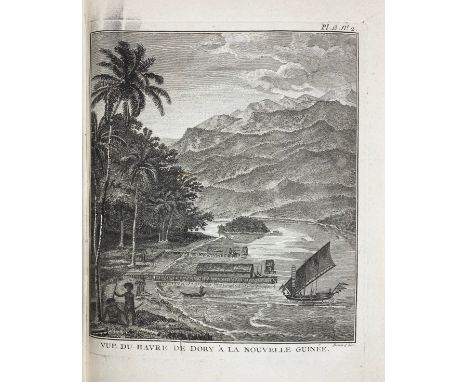
MARITIME HISTORY - TRAVELLING -- FORREST, (T.). Voyage aux Moluques et à la Nouvelle Guinée, fait sur la galère la Tartare en 1774, 1775 & 1776, par ordre de la Compagnie Angloise. Par., Hôtel de Thou, 1780. (6), 470, (1) pp. W. 1 large fold. engr. map & 28 (fold.) maps/plates. 4°. Old brds., uncut. (Paper on brds. a bit stained/soiled & sl. dam., stamp scratched out on ti., but else a very clean copy with ample, uncut margins). NOTE: The first French edition. On the first English ed. of 1779, Hill 623: "In 1774, when the council, in accordance with their instructions and with a view to developing new sources of trade, desired to send an exploring party in the direction of New Guinea, Forrest offered his services. He sailed in the Tartar, a native boat (...). The voyage was one of examination and enquiry rather than of exploration, and the additions made to geographical knowledge were corrections of detail rather than startling discoveries, but the tact with which he conducted his intercourse with the natives, and the amount of work done in a small boat, deservedly won him credit as a navigator". - Rouffaer/Muller I, p.479; cf. Cat. NHSM I, p. 242.

WUNDERKAMMER -- (SCHEURLEER, H.F.?). Schatkamer der verborgentheden, voorgestelt in een beschryvinge der wonderlyke geschapenheit des firmaments, sterren, planeten, cometen (...). Amst., J. Ratelband, 1713. (44), 463, (21) pp. W. 26 (fold.) engr. plates (of 27?) of the stars, plants, animals (whales!), etc., incl. a map of the oceans of the world. 4°. Cont. cf. w. gilt title on spine. (Calf detaching from boards, bottom of spine dam., hinges weak, loosening, lacking leaf 6*4, fold. map a bit torn (but complete and restoreable), some faint marg. stains). NOTE: Extremely rare, only 1 copy in NCC (Nijmegen) and 1 o. in Katalog der Univ. Frankfurt. - Sold w.a.f., not subject to return.

ZEELAND -- GLATZ, J. Familie-tafereelen en verhalen voor de jeugd. Dordt., 1824. W. 2 plts. Cont. vellum w. gilt coat of arms of Middelburg on both sides. (Prize lacks). Spoelders 645 (Middelb. 6). -- H. SLUIJTERS. Aardrijkskundige beschrijving van de Provincie Zeeland. Breda, 1836. W. 1 fold. map of Zeeland. Cont. stiff wrps. (Bind. delicate, some yellowing, textblock remarkably clean). -- J.A. MANUS v.d. JAGT. Lees- en leerboekje over de eerste beginselen der aardrijkskunde en de provincie Zeeland. 3de verb. & verm. dr. Zierikzee, 1862. Cont. stiff wrps. -- And 2 o. (5).

ZEELAND -- MUYT, P.N. Geschied- en aardrijkskundige beschrijving der Provincie Zeeland, ten gebruike der scholen. Z. Boemel, J. Noman, 1821. W. woodcut ti.-vign. of the abbey of St. Nicolaas & fold. map of Zeeland. Sm-8°. Owrps. (Spine dam.). -- H.M. KESTELOO. Wandelingen door de voormalige smalstad Domburg. Middelbrug, van Benthem & Jutting, 1871. Cont. hcl. w. owrps. laid down. -- (2).

RUSSIA -- CHOPIN, (J.M.) (&) C. FAMIN. Russie, La Crimée, et les provinces Russes en Asie, Circassie et Géorgie, Arménie. Par., Didot Frères, 1838-42. 2 vols. 672, 144 pp. W. 9 steel-engr. maps & circa 170 steel-engr. views, portrs., etc. Cont. h. brown cf. w. marbled sides. (Binds. a bit rubbed, yellowing throughout, some waterstaining, 1 map neatly repaired, but a good set).

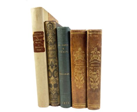
CHINA - JAPAN -- MEIGNAN, V. De Paris a Pékin par terre Sibérie — Mongolie. 2e éd. Par., 1876. W. fold. cold. map (laid down on linen) & 15 plates by L. Breton. Cont. cl. (Stamps on ti., sl. yellowed). -- M. HUC. Souvenirs d'un voyage dans la Tartarie, le Thibet et la Chine pendant les années 1844, 1845 et 1846. 2e éd. Par., 1853. 2 vols. W. 1 fold. map. Cont. hcf. w. dec. gilt backs. (Spines a bit faded). -- P. PARLEY. Histoire de la Chine et des Chinois. (c. 1850). W. plates. Blind tooled & gilt dec. cl. (Extremities sl. worn, some minor foxing). -- And 1 o. (5).


STEMFOORT, J.W. & J.J. ten SIETHOFF. Atlas der Nederlandsche bezittingen in Oost-Indië naar de nieuwste bronnen samengest. (…). Gereprod. op last v.h. Dept. v. Koloniën, aan de Topogr. Inrichting te 's Gravenhage, o.l.v. C.A. Eckstein. 's-Grav., 1883-85. W. cold. lithogr. double-p. ti. w. inset general map and legenda, and 14 fine cold. lithogr. double-p. maps (image size c. 580 x 850 mm!). Lge-fol. Ohcl. w. corners. (Boards worn & (water)stained, some maps delicate or slightly torn at the attachment point but generally very good & clean). NOTE: Koeman VI, Stem A1.

CARIBBEAN -- SIMONS, G.J. Beschrijving van het eiland Curaçou. Oosterwolde, de Tempe, 1868. 156 pp. W. lithogr. portr., 1 map & 2 cold. lithogr. plates. Hcl. w. owrps. mounted. (Some yellowing). -- Added: HET SPRINGEN van 's Lands Oorlogsschip Alphen voor Curacao den 15 september 1775. Handcold. engr. (130 x 130 mm.). -- And 2 o. engrs. (4). NOTE: Tiele 1005. Rare.

VERNON, P.E. Morocco from a motor. W. fold-out map at end. - A.S. FORREST. Morocco. - J. KELMAN. From Damascus to Palmyra. - E.F. CAREY. The Channel Islands. - R.T. KELLY. Egypt. - B. JUNGMAN. Holland. - J.F. DICKIE. Germany. - T. VARLEY. Hampshire. (W. dust-j.!). - E.T.A. WIGRAM. Northern Spain. - A.G. BRADLEY. Rivers and Streams of England. - And 9 similar. - Lond., A. & C. Black, 1904-27. 19 vols. of the series. Prof. ill. in colour by artists of that time. Lge-8°. Or. fine and colourful dec. cl., t.e.g. Very well produced travel books, all in very good/fine condition.

COUTANS, G. & Ch. PICQUET. Atlas topographique en XVI feuilles des Environs de Paris. Par., Picquet 1836. W. 'Tableau d'assemblage' (ti. & map) & 16 double-p. maps. Lge-fol. Mod. hcl. (W. small stamp on each map, a few rep., a bit browned/foxed). NOTE: Very detailed maps of the surroundings of Paris, they cover the regions of Gisors, Beaumont, Senlis, La Ferté Milon, Mantes, Pontoise, Meaux, Château-Thierry, Dreux, Versailles, Brie sur Yerres, Coulommiers, Chartres, Etampes, Melun & Provins.
(LAPIE, P. Atlas universel de géographie ancienne et moderne (…). Par., Eymery, Fruger & Cie, c. 1832). W. 50 fine engr. maps, partly cold. in outlines. Lge-fol. Cont. hcf. w. marbled sides and ties. (First two maps w. libr. stamp in image, some foxing as usual, map 22 w. faint circular stain). NOTE: Individual maps dated 1828-1832 and all warranted w. small blind stamp. Contains i.a. a worldmap (presented in 2 hemispheres/Mercator-projection), a celestial map, a representation of the planetary system and maps of Europe, India, China, Oceania, Africa, North- and South-America.

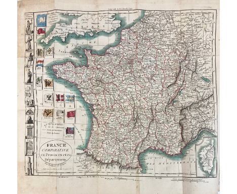
LEVASSEUR, E. Atlas national illustré des 86 départements et des possessions de la France. Par., A. Combette, 1847. W. steel-engr. ti., table, map of France, 93 numb. maps of the colonies and departments & 6 maps of the continents, cold. in outlines. Lge-fol.-obl. Cont. h. mor. w. dec. gilt back. (Spine rubbed/chafed, corners bumped, some marg. stains, sl. browned).
PINKERTON, J. Abrégé de la géographie moderne. Par., 1805. W. 9 fold. maps, cold. in outlines. Cont. marbled cf. w. dec. gilt back & red label. -- J.B. VOSGIEN. Nouveau dictionnaire géographique, ou description de toutes les parties du monde. Dernière éd. Ornée de cartes géographique (...) p. M.B. & Hocquart. Par., 1817. W. 7 fold. maps, cold. in outlines. Cont. hcf., w. dec. gilt back & brown label. -- M. DELETTRE. Manuscript atlas. (C. 1850). 14 handcold. manuscript full-p. maps w. double-column manuscript description to adjacent pages. 4°-obl. Cont. clothbacked brds. (Corners worn/bumped, some dam. to upper outer margin (tears occas. touching map-border), lightly spotted). -- (3).

POULAIN DE BOSSAY, P.A. Atlas de géographie historique pour servir à l'intelligence de l'histoire ancienne. Paris, L. Colas, 1847. W. 12 maps (5 cold., 7 cold. in outline). Hcl. (Some yellowing). -- Ch. PÉRIGOT. Atlas historique et géographique (…) pour l'admission a l'école militaire de Saint-Cyr. Paris, Delagrave, 1875 (-1880). 2 vols. W. 90 cold. maps (3 fold.). Mod. cl. w. wrps. pasted on. (Maps in both vols. very well-preserved). -- M. LETRONNÉ. Atlas de géographie ancienne pour (…) oeuvres de Rollin. Paris, Firmin Didot, 1827. W. 17 double-p. maps cold. in outline. Obrds. (Wear to extremities, maps very good & clean). -- (J.B.B. D'ANVILLE). Atlas de géographie ancienne (…) oeuvres de Rollin. Paris, Lequien, 1827. W. 18 double-p. maps cold. in outlines. Cont. hcf. (Bumped & chafed, title-p., index & first map slightly waterstained). -- And 3 other atlasses published in Paris. (8).

(TARDIEU, A.) Atlas de géographie ancienne pour (…) oeuvres de Rollin gravé d'apres les cartes originales de D'Anville. Paris, Ledoux & Tenré, 1818. W. 27 maps. Cont. hcf. (Maps remarkably crisp & clean). -- L. DUSSIEUX. Atlas général de géographie physique, politique et historique. Paris, Lecoffre, (1860?). W. 157 maps, partly cold. in outlines (1 fold. map, clumsily repaired). Cont. hcf. -- J. BABINET. Atlas universel de géographie physique, politique et historique. Paris, Bourdin, (1860?). W. 60 cold. maps. Cont. hcl. (Back side detached, upper hinge weak, some yellowing, several maps flanked by extensive annot. in ink & pencil). Executed according to homalographic projection. -- LORRAIN. Carte de la Hollande par provinces. Dressée d'après la carte de Kraijenhoff. Rev. p. H. Reding. (Par.), Binet, (1840). W. engr. ti. & 11(1 lge-fold.) engr. maps, cold. in outlines. -- C.V. MONIN & A.R. FRÉMIN. Atlas universel de géographie ancienne et moderne. Par., Binet, (c. 1840). W. engr. ti. & 49 engr. maps, cold. in outlines. -- And 4 o. atlasses published in Paris. (8).

VUILLEMIN, A. Bassins des grands fleuves de la France et de l'Europe. Édition avec tracé des lignes des chemins de fer. Paris, J. Delalain, (1893?). W. 17 maps cold. in outlines (2 fold. maps). 4º. Cont. cl. (Upper hinge loose, 1 map loose, fold. maps tears at fold, some yellowing but colours very crisp). -- Id. La France et ses colonies. Atlas illustré. Paris, Migeon, 1852. W. 100 maps cold. in outlines (of which 1 fold.). 4°-obl. Cont. hcl. (Wear to extremities). -- V.A. MALTE-BRUN. La France illustrée. Geographie, histoire, administration et statistique. Paris, Barba, (n.d. but around 1860). 3 vols. W. many text-ills. Atlas vol. w. 93 maps, partly cold. (of which 2 fold.). Lge-8º. Cont. hcf. -- And 2 o. (7).
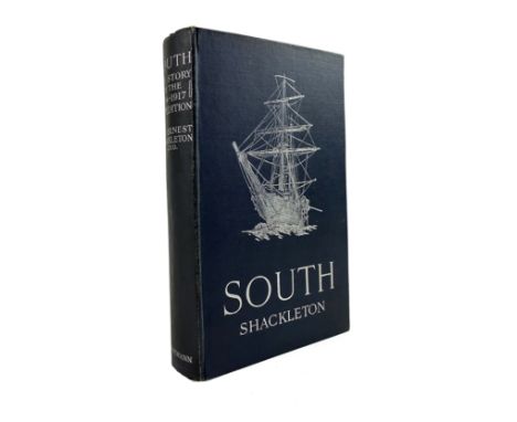
SHACKLETON, E.H. South. The story of Shackleton's last expedition 1914-1917. Lond., W. Heinemann, 1919. xxi, (1), 371, (1) pp. W. cold. front., half-tone illustrations, folding map, errata slip tipped-in. Or. dark blue cloth w. silver lettering & illustration of the "Endurance" blocked in silver on front side. (Small tear to map stub, toned throughout as usual, else a fine copy in a sound binding). NOTE: One of the most evocative narratives of the Heroic Age of Antarctic exploration, telling of the survival of Shackleton and his crew under the most extreme circumstances. - First edition, first issue.

SWITZERLAND --JOANNE, A. Itinéraire descriptif et historique de la Suisse. Par., 1841. W. cold. front., fold. map printed on silk, & 2 fold. panoramas. Cont. hcf. w. dec. gilt back. (Sl. foxed). -- Ph. GOLBÉRY. Histoire et description de la Suisse. Par., 1838. W. fold. map & num. plates. Cont. hcf. w. dec. gilt back. -- (H. MALLET). Itinéraire général de la Suisse. Geneva, 1810. W. 4 lge-fold. plates. Cont. hcf. w. orange label. -- And 1 o. (4).

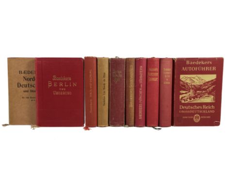
BAEDEKER, K. Deutsches Reich (Grossdeutschland). Offizieller Führer des deutschen Automobil-Clubs. 2. Aufl. Lpz., 1939. W. 70 town plans: partly cold. & fold./partly in text, 1 cold. table (traffic signs), 1 distance table and 1 section title w. general map of all the highways. Ocl. w. dust-j. (Dust-j. has some wear and the upper lower corner front side is chipped, without 'Strassenzustandskarte' which was added loose). National Socialist edition. -- Added: Id. Nordwest-Deutschland. (v.d. Elbe und der Westgrenze Sachsens an, nebst Hamburg und der Westküste von Schleswig-Holstein). 31. Aufl. Lpz., 1914. W. 54 maps & 86 plans. Ocl. w. almost impeccable dust-j. -- Id. Berlin und Umgebung. Lpz., 1914. W. 5 maps, 10 plans and 17 floor plans. Ocl. -- And 7 o. of Germany (not collated), 3 w. dust-j. (10). NOTE: Hinrichsen D256.
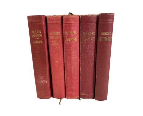
BAEDEKER, K. Konstantinopel, Balkanstaaten, Kleinasien, Archipel, Cypern. 2. Aufl. Lpz., 1914. W. 18 maps, 50 plans and 15 floor plans. Sm-8°. (Spine skillfully rep., 1 fold. map at end a bit dam., but a good copy). -- Id. Palestine et Syrie, routes principales a travers la Mésopotamie et la Babylonie, l'ile de Chypre. 4me éd. Lpz., (etc.), 1912. W. 21 maps, 56 plans and a panorama of Jerusalem. (Some unobtrusive staining in places). -- Id. Ägypten und der Sûdân. 7. Aufl. Lpz., 1913. W. 21 maps, 84 (floor) plans and 55 illustr. -- Id. Egypt and the Sûdân. 8th rev. ed. 1929. W. 106 maps & plans, 56 woodcuts. -- Id. Mittelmeer. Seewege, Hafenplatze, Landausflüge. Mit Marokko, Algerien, Tunesien. 2. Aufl. 1934. W. 43 maps and 46 plans. -- 5 vols. Sm-8°. Ocl. NOTE: Hinrichsen D498; F220; D493; E253; D418.
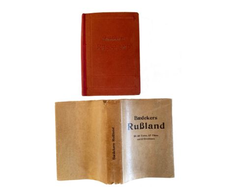
BAEDEKER, K. Rußland nebst Teheran, Port Arthur, Peking. 7. Aufl. Lpz., 1912. W. 40 maps, 67 plans and 11 floor plans. Sm-8°. Ohcl. w. dust-j. (Back skillfully rep./replaced (paste-downs preserved!), dust-j. a bit chipped in places, small rep. to general map preceding ti.-p., but a good copy). NOTE: Hinrichsen D463 (no dust-j. mentioned).
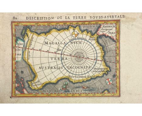
ANTARCTICA -- "DESCRIPTION de la Terre Soubs-Australe" (sic!). Amst., J. Hondius, (1618). Engr. map, cold. by hand, with title in French on v°. 97 x 135 mm. (paper size 117 x 180 mm.). (Hinges from previous mount present on v°). NOTE: Engraved map of the South Polar unknown lands, with sailing ship, sea monster and two compass roses. This was one of the first maps to focus on the South Pole. From Bertius' "La Geographie Racourcie". - V.d. Krogt IIIA, 342:11 (plate 10, p. 451) (0030:342).


ASIA -- "ACCURATISSIMA ASIÆ Tabula (…)". Amst., F. de Wit, n.d. (c. 1660). Engr. map in cont. colouring w. fine cartouche, embellished w. puppets and a camel. 480 x 570 mm. Framed, glazed and under passepartout. (Uninspected out of frame). NOTE: Second state with renewed title, no text on v°. - Koeman III, p. 212.

ASIA -- "ASIA ACCURATISSIME DESCRIPTA". Engr. map by N. Witsen, in cont. handcolouring, w. dec. cartouche. Amst., P. Schenck, (c. 1700). 490 x 587 mm. (Some repaired tears/small holes, a few small stains, remnant of tape & of previous hinges). -- "TABULA GEODOBORICA Itinerum a Varijs in Cataium Susceptorum Rationem Exhibens". (c. 1667). Engr. map of Asia depicts the land and sea routes from the Middle East to China and northern Asia. Embellished with two cartouches and Chinese merchants. From Kirchner's 'China Illustrata'. 417 x 525 mm. -- (2).

ASIA -- "ASIA Concinnata Secundum Observationes Academia Regalis Scientiarum et nonnullas alias, et juxta annotations recentissimas per G. de l'Isle". Augsburg, T.C. Lotter, n.d. (c. 1780). Engr. map in cont. colouring. 493 x 584 mm. (Surface a bit rumpled, small rep. to v°-side, but in a good condition).

ASIA -- "ASIA ex magna orbis terræ descriptione Gerardi Mercatoris desumta, studio et industria G.M. Iunioris". (Amst., Hondius, between 1607 and 1612). Cold. engr. map. 382 x 472 mm. (Lower part of central fold split, but in very fine condition). NOTE: V.d. Krogt 8000:1A (Latin text on v°).

ASIA -- "ASIA NOVITER DELINEATA." Amst., J. Blaeu, (c. 1635). Engr. map by W. Blaeu in cont. colouring w. title in cartouche, in upper margin 9 Asian towns in oval frames (Candy, Calecut, Goa, Damascus, Jerusalem, Hormuz, Banten, Aden and Macao), accompanied on both sides by 5 costumed Asian figures. 410 x 555 (image size). All margins fixed to passepartout. NOTE: Van der Krogt II, 8000:2 (Dutch text on v°); Schilder 6, 21:2. In very good condition.

ASIA -- "ASIA QUA NULLA BEATIOR ORA". Amst., G. & L. Valk, (c. 1720). Engr. map in cont. colouring with large decorative title cartouche. 480 x 590 mm. Framed, glazed and under passepartout. (With five visible repaired tears, upper margin probably cut short (not visible due to framing), some foxing spots, uninspected out of frame). NOTE: Scarce large general map of the Continent Asia and a part of Australia, extending to the East indies. Papua New Guinea with attachment to Australia via a coastline called "Carpentaria". - Sold w.a.f., not subject to return.


ASIA -- "ASIE divisée en ses principaux Etats, Empires & Royaumes par Robert de Vaugondy (…) Corrigée et augmentée (æ) par C.F. Delamarche". (Paris), 1791. Engr. map cold. in outlines. 507 x 678 mm. -- Added: "L'ASIE dreßée pour l'étude de la Géographie, revue et augmentée par Mr. Brion". Paris, Desnos, n.d. (1771). Cold. engr. map surrounded by highly decorative border and 2 columns of explan. text. 235 x 265 mm (map size). -- (2).

ASIA -- "GENERALIS TOTIUS IMPERII RUSSORUM Novissima Tabula (…)". Nürnberg, J.B. Homann, n.d. (c. 1715). Engr. map in cont. colouring. 483 x 565 mm. (Margins short). -- Added: "BRITISH EMPIRE Throughout the World Exhibited in One View". Edinb., (etc.), A. Fullarton & Co., (c. 1860). Engr. cold. world map representing the British Empire (possessions cold. red), inhabitants depicted in 2 wide bands at the top and bottom engr. by A. Thom. 426 x 525 mm. -- And 6 o. maps. (8).

ASIA -- "INDIA QUÆ ORIENTALIS dicitur, et insulæ adiacentes." (Amst., W. & J. Blaeu, c. 1640). Engr. map in cont. colouring of South-East Asia. 420 x 510 mm. All margins fixed to passepartout. (Centerfold strengthened w. strip of linen on v°). (Some foxing spots, else fine). NOTE: Van der Krogt II, 8400:2 (French text on v°).

ASIA -- "INDIÆ ORIENTALIS nec non Insularum Adiacentium. Nova descriptio edita p. F. de Witt". (Amst., n.d., after 1688). Engr. map in cont. colouring. 515 x 605 mm. (Margins of outer sides cut short/on plate edges, a bit browned on central vertical fold, small hole in upper left corner, unobtrusive crack in paper in lower left corner, but a magnificent map). NOTE: Decorative early map showing the northern part of Australia in lower right corner, Indonesia in the middle and India in upper left corner.
-
109198 item(s)/page