We found 109182 price guide item(s) matching your search

Refine your search

Year

Filter by Price Range
  • List
  • Grid
  • 109182 item(s)
    /page

Lot 126

Fiala (Anthony). Fighting the Polar Ice, 1st US edition, New York, 1906, colour frontispiece, folding map at end (with short closed tear), half-tone illustrations, original blindstamped green cloth gilt in bright condition, spine ends a trifle rubbed, 8vo Account of the second Ziegler expedition to the North Pole (1903-05), which failed and resulted in the loss of the expedition's ship "America". (1)

Lot 66

Tilman (H.W.). The Ascent of Nanda Devi, 1st US edition, 1937, folding map, numerous sepia illustrations (plate at p. 74 with small pieces adhered from opposite text), endpapers a little toned, original cloth, spine faded, 8vo, together with Snow on the Equator, 1st US edition, New York, 1938, maps and half-tone illustrations, some toning to endpapers, original cloth, 8vo, with 11 others by Tilman, including China to Chitral, 1951 and Nepal Himalaya, 1952 (17)

Lot 199

Europe. Munster (Sebastian), Untitled map of Europe as a woman, circa 1580, uncoloured anthropomorphic map of Europe as a queen, with Iberia at the head with Italy and Denmark comprising the arms, some spotting, 290 x 170 mm, German text above and on verso of map A design originally created by Bucius (Johannes Putsch) in 1537. It has been postulated that the character of the map is not a woman at all but a representation of Charles V of Spain showing Europe with Spain as its crown. In light of the recent referendum in the United Kingdom it is perhaps apposite that the British Isles are shown separate from and not integrated into the main body and figure of the map. (1)

Lot 181

Allegorical map. Gillray (James), Britannia, published H. Humphrey 1791 [but H. G. Bohn impression, circa 1850], uncoloured engraved map, 270 x 195 mm, on sheet with three other caricatures with another four caricatures to verso (as published), with another three sheets from the same series, all printed 'back-to-back' and comprising of another twelve caricatures, each sheet approximately 540 x 370 mm (4)

Lot 208

London. Wyld (James), A New Plan of London and Westminster with the Borough of Southwark, 1825, published James Wyld (Successor to Mr Faden), 1825, engraved map with contemporary hand colouring, sectionalised and laid on linen, slight offsetting, marbled endpapers, 385 x 660 mm, contained in a contemporary marbled card slipcase with printed label to upper board, label with additional ink manuscript title, with another another uncoloured folding engraved plan of London, laid on linen, margins frayed, dust soiled, 385 x 535 mm The first map described: Howgego 302, state 2. (1)

Lot 141

Seemann (Berthold). Narrative of the Voyage of H.M.S. Herald During the Years 1845-51, under the Command of Captain Henry Kellett, Being a Circumnavigation of the Globe, and Three Cruizes to the Arctic Regions in search of Sir John Franklin, 2 volumes, 1st edition, 1853, colour lithograph frontispiece to each, folding colour map, publisher's catalogue at end of volume II, light marginal toning, library stamps to front endpapers, previous owner signature, hinges a little tender, original blue blindstamped cloth, small indentations to volume I edges, small split to volume II upper joint, a little rubbed, 8vo Hill 1546; Howes S271; Sabin 78867. Seemann was the naturalist aboard the Herald, which set out to measure the hydrography of the Pacific Ocean and subsequently searched for the lost Franklin Arctic expedition. (2)

Lot 225

Surrey. Morden (Robert), Surrey [1695], hand coloured engraved map, 365 x 425 mm, together with Van den Keere (Pieter), Coruwallia, Buckingham shire, Devonshire, Essex County, Glocester Shire, Lincolne Shire, The Bishopprick of Durham, Mounmouth Shire, Northumberland, Nottinghamshire, Warwicke Shire, Wilt Shire, Worcestershire, Glamorgan Shire, Radnor Breknok Cardigan et Caermarden descript, Mone Ins et Carnarvan, Denbigh ac Flint..., [and] Denbigh and Flint described, circa 1616, together eighteen miniature engraved maps, a few maps with sparse outline colouring, each approximately 85 x 125 mm, various condition, with English and Latin text on verso, plus Cary (John), A Collection of approximately ninety county maps, originally published in 'Cary's Traveller's Companion...', circa 1817, engraved maps with contemporary outline colouring, several duplicates, each approximately 150 x 100 mm, various condition, and Moule (Thomas), Buckinghamshire, circa 1848, hand coloured engraved map, 265 x 200 mm (approx.110)

Lot 21

Cowperthwait (Thomas, publisher). A New Universal Atlas containing maps of the various empires, kingdoms, states and republics of the world, with a special map of each of the United States, plans of cities &c. comprehended in seventy-five sheets and forming a series of one hundred and twenty two maps plans and sections, published Philadelphia, 1854, chromlithographic decorative title, contents list, frontispiece of a comparison plate of the rivers and mountains of the world, seventy-three (complete as list) lithographic maps (including two double page), all with contemporary hand colouring, a few maps with fraying and chipping to fore-edge, text block detached, contents shaken and loose, contemporary half morocco, boards detached, lacking spine, worn and frayed, morocco gilt title label to upper siding, folio The Cowperthwait edition of S. A. Mitchell's atlas. (1)

Lot 4

Arrowsmith (Aaron). Outlines of the World, 1825, title page with an engraved vignette portrait of the author, dedication and index, forty-four (complete) engraved maps with contemporary outline colouring, some finger and dust soiling to the map of Africa, slight spotting, some marginal dust soiling throughout, contemporary half calf gilt, rubbed and worn, folio (1)

Lot 214

*Ogilby (John). The Road from Bristol com. Somst. to Exter com. Devon, [1675 or later], hand coloured engraved strip road map, trimmed to neat line and laid on later card, manuscript date (1675) in cartouche, 345 x 445 mm, mounted, framed and glazed (1)

Lot 70

Warren (Captain F.G.E.). My Journal During the Bhootan Campaign, 1864-5, pp. 116-160, two lithographed maps (one folding), illustrations, closed tear to page 145, a couple of small marginal chips, modern cloth, 8vo Published in the Minutes of Proceedings of the Royal Artillery Institution, volume V, 1867. "Captain Warren of the Royal Artillery participated in the war as a member of the column of the Bhutan Field Force under the general command of Major-General Mulcaster. He gives a detailed account of the campaign with maps and sketches. A map of the Bhutan Duars showing the area to be annexed is also included." (Julie Marshall, Britain and Tibet 1765-1947, 2005). (1)

Lot 217

Scotland. Hondius (Henricus), Orcadum et Schetlandiae Insularum accuratissima descriptio, circa 1636, two engraved maps on one sheet (as published), contemporary hand colouring, slight overall toning, 380 x 485 mm, English text on verso, together with Pont (Timothy & Blaeu Johannes), Glottiana praefectura superior, Teviotia vulgo Tivedail, Mercia vulgo vice comitatus Bervicensis [and] Knapdalia provincia..., The Province of Knapdale which is accounted a member of Argyll, circa 1660, together four hand coloured engraved maps, slight toning, some fraying to margins, each approximately 430 x 535 mm, various languages on verso, with Collins (Captain Greenville), The south part of the Isles of Shetland, circa 1700, hand coloured engraved sea chart, slight dust soiling, slight creasing, central fold strengthened on verso with slight loss at upper margin, 445 x 555 mm, plus Blaeu (Johannes), Insula Sacra vulgo Holy Island et Farne, circa 1650, hand coloured engraved map, some offsetting, 390 x 475 mm, Latin text on verso, with two uncoloured engravings of Scottish cities and towns originally published in Mr. Rapin's History, slight staining and occasional marginal closed tears, each approximately 360 x 460 mm (9)

Lot 222

Surrey. Bryant (Andrew), Map of the County of Surrey from actual survey by A.Bryant in the years 1822 and 1823, published June 1st 1823, engraved map with bright contemporary hand colouring, sectionalised and laid on linen on four sheets, each edged with red silk, calligraphic title, compass rose, table of explanation and a table of ecclesiastical divisions, very slight offsetting, red endpapers with later manuscript titles, each sheet approximately 670 x 805 mm, contained in a near contemporary red morocco slipcase with later felt pen manuscript titles to upper board and spines, a little worn at extremities (1)

Lot 78

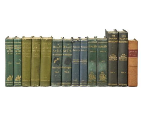
Baker (Samuel White). The Albert N'Yanza, Great Basin of the Nile and Explorations of the Nile Sources, 2 volumes, 1st edition, 1866, portrait frontispiece to volume I, colour lithograph frontispiece to volume II, two colour maps (one folding with closed tear), wood-engraved illustrations, volume II title close-trimmed at foot shaving imprint, presentation note remnants to front endpapers, original green cloth gilt, a little rubbed, slight lean, 8vo, together with Du Chaillu (Paul B.), A Journey to Ashango-Land: And Further Penetration into Equatorial Africa, 1st edition, 1867, wood-engraved frontispiece, folding map (now tipped-in at rear pastedown), illustrations, a little light spotting, modern brown half morocco, 8vo, plus Junker (Wilhelm), Travels in Africa During the Years 1875-1878, 1879-1883, 1882-1886, translated from the German by A.H. Keane, 3 volumes, 1st English editions, 1890-92, portrait frontispiece to each, folding maps (repairs to verso), illustrations, some light spotting and soiling, original green pictorial cloth, a little rubbed with a few stains, 8vo, with others related including Verney Lovett Cameron's Across Africa, 2 volumes, 1877, Georg Schweinfurth's Heart of Africa, 2 volumes, 1873, and Samuel White baker's Ismailia. A Narrative of the Expedition to Central Africa for the Suppression of the Slave Trade, 2 volumes 1874 (28)

Lot 228

World. The Pictorial Missionary Map of the World, Drawn by John Gilbert, Engraved and Printed by Edmund Evans, Published by James Nisbet, circa 1860, double hemisphere wood-engraved map printed in colours with vignettes to borders, 46.5 x 72 cm, linen backed, minor edge fraying and paper partly separated from backing (1)

Lot 32

Foa (Edouard). After Big Game in Central Africa..., translated from the French, with an Introduction by Frederic Lees, 1st edition, 1899, portrait frontispiece, map and half-tone illustrations, advertisements at end, ink stamp of the Royal National Parks of Kenya to rear endpaper, a few thumbmarks, top edge gilt, original cloth gilt, spine darkened, joints and edges rubbed, 8vo, together with In Wildest Africa, byC.G. Schillings, translated by Frederic Whyte, 2 volumes, 1907, half-tone illustrations, a few minor spots, endpapers renewed, original pictorial cloth, Norfolk & Norwich Library stickers to upper covers, a few mottled stains, 8vo, plus The Wanderings of an Elephant Hunter, by W.D.M. Bell, 1st edition, 1923, monochrome illustrations, a few light spots, small previous owner inscription, original cloth-backed boards, some fading and light flecked stains, 4to, with four others including C.G. Schillings With Flashlight and Rifle, second and popular edition, circa 1906, Marius Maxwell's Stalking Big Game in Equatorial Africa with a Monograph on the African Elephant, 1924 and John G. Millais' Far Away Up the Nile, 1924 (8)

Lot 20

Cooch Behar (Nripendra Narayana Bhupa, Maharaja of). Thirty-Seven Years of Big Game Shooting in Cooch Behar, the Duars and Assam, 1st edition, 1908, folding map, half-tone illustrations, occasional light marginal soiling, original blue cloth gilt, spine a little faded and neatly repaired at ends, 4to (1)

Lot 58

Ronaldshay (Earl of). Lands of the Thunderbolt. Sikhim, Chumbi & Bhutan, 1st edition, 1923, folding map, 32 half-tone plates, endpapers lightly toned, original blue cloth, one or two small bumps, 8vo (1)

Lot 133

McClure (Robert). The Discovery of the North-West Passage by H.M.S. "Investigator," Capt. R. M'Clure, 1850, 1851, 1852, 1853, 1854, edited by Captain Sherard Osborn from the logs and journals of Capt. Robert Le M. M'Clure, illustrated by Commander S. Gurney Cresswell, R.N., 2nd edition, 1857, engraved portrait frontispiece, folding map, four lithographed plates, 24 pp. pulisher's catalogue at end, some light offsetting and spotting, previous owner signature to front endpaper, original blue blindstamped cloth, rebacked with original spine relaid, a little rubbed, 8vo Sabin 43073. Presentation copy, inscribed to half title: "With the kindest regards of Sherard Osborn". (1)

Lot 190

British Isles. Jansson (Jan), Britannia prout divisa suit temporibus Anglo-Saxonum praesertim durante illorum Heptarchia, circa 1648, engraved map with contemporary hand colouring, strapwork cartouche, compass rose and numerous rhumb lines, fourteen engraved vignettes showing historical scenes to vertical margins, 420 x 530 mm, German text on verso, some staining to verso (1)

Lot 194

Dighton (Robert). Geography Bewitched! or a droll caricature map of England and Wales, published Bowles & Carver, circa 1810, uncoloured engraved map, (watermarked J. Whatman 1811), occasional repaired marginal closed tears, slight thinning to paper, 210 x 170 mm (1)

Lot 218

Sea chart Doncker (Hendrik), De Zee-kust van Engelandt tusschen Welles en 't Eylandt Coket, published Amsterdam, circa 1686, engraved chart of the east coast of England, contemporary outline colouring, inset map of the River Tyne, small printers fold, 430 x 525 mm Originally published in 'Le Grand & Nouveau Miroir ou Flambeau, de la Mer contenant la description de toutes les costes Marines Occidentalled & Septentrionalles...,'. (1)

Lot 206

Glamorganshire. Blaeu (Johannes), Glamorganensis comitatus vulgo Glamorganshire, circa 1645, engraved map with contemporary hand colouring, 385 x 510 mm, Dutch text on verso (1)

Lot 102

Stanley (Sir Henry Morton, 1841-1904). The American Testimonial Banquet to Henry M. Stanley, In recognition of his Heroic Achievements in the cause of Humanity, Science & Civilization and A Greeting to his Chief Officers. Portman Rooms, London, May 30th, 1890, 11 printed sheets mounted on thick card, with photographic portraits of Stanley, Stairs, Parke, Nelson, Mounteney-Jephson, some light spotting, all edges gilt, original embossed calf, rebacked, a little rubbed, 8vo, with a loose admission ticket for Alfred H. Mason to the banquet, together with Manchester Chamber of Commerce. Address of Mr. H.M. Stanley on England and the Congo and Manchester Trade, and the Work and Aims of the International Association, 1884, 39 pp., a little toned, disbound, plain wrapper, 8vo, plus Proceedings of the Royal Geographical Society and Monthly Record of Geography. A Visit to Mr. Stanley's Stations on the River Congo, by H.H. Johnston, 1883, 570-592 pp., folding map (with ink stamp), modern wrappers, with four others including Stanley's First Opinions. Portugal and the Slave Trade, Lisbon, 1883 (7)

Lot 160

Gray (George Carrington). Gray's New Book of Roads. The Tourist and Traveller's Guide to the Roads of England and Wales and Part of Scotland on an Entirely new Plan..., published Sherwood, Jones and Co., 1824, appears to lack additional decorative title page, frontispiece of a folding map of England & Wales, preface with ink stamped ownership, with another stamp to rear of map of Derbyshire, 191 pages of cross roads, forty-nine uncoloured engraved maps (complete as list) including two folding (Derbyshire and The Isle of Thanet), index bound at rear, new end papers, modern half cloth retaining near contemporary morocco gilt title label to spine, 12mo, together with Phillips (Richard, publisher), A Guide to all the Watering and Sea-Bathing places; with a description of the Lakes; A sketch of a tour in Wales and Itineraries..., circa 1805, printed title and advertisement, nineteen uncoloured engraved maps including four folding and thirty engraved plates, including one folding, some spotting throughout, modern endpapers, modern half morocco, 12mo The first described item. Chubb CCCXCII. (2)

Lot 168

Wainwright (Alfred). A Pictorial Guide to the Lakeland Fells, volumes 1-7, 1st editions, 1955-1966, black & white illustrations, original limp cloth, all in dust jackets except first volume (some marked & worn with few tears), 8vo, together with Westmorland Heritage, 1st edition, Kenal: Westmorland Gazette, 1975, black & white illustrations, original cloth in dust jacket (slightly faded), oblong 4to (limited edition 127/1000, signed by Wainwright), with Wainwright in Lakeland, 1st edition, Kendal, 1983, black & white illustrations, folding map in pocket at rear, original cloth in dust jacket, oblong 4to (number 522 of unspecified limitation, signed by Wainwright), and Davies (Hunter), Wainwright, the Biography, 1st edition, 1995, black & white plates, half title signed by the author, original cloth in dust jacket, 8vo, and Davies (Hunter, edit.), The Wainwright Letters, 1st edition, 2011, black & white portrait frontispiece, title signed by Hunter Davies, original cloth in dust jacket, 8vo, plus other Wainwright and Lake District related, including walking guides (approx. 100)

Lot 216

Satirical map. Lehmann-Dumont (Karl), Humoristische Karte von Europa im Jahre 1914, published Dresden, 1914, colour printed photolithographic allegorical map, inset map of Japan, old folds with small holes where folds cross, 350 x 490 mm An uncommon allegorical depiction of Europe, with the bias on Germany and Prussia. Undoubtedly published for amusement it concentrates on the national characteristics and the foibles of each nation, but there is also a more disturbing element of propoganda. The date of publication and the depiction of national stereotypes will prove to be highly prophetic of the carnage that was shortly to engulf the continent. (1)

Lot 120

Chapman (F. Spencer). Northern Lights. The Official Account of the British Arctic Air-Route Expedition 1930-1931, 2nd impression, December 1932, 64 black and whtie plates and maps, period inscription to front endpaper, front gutter split, some minor spotting, original blue cloth, spine lightly faded, 8vo, together with Vale Blake (E.), Arctic Experiences: Containing Captain George E. Tyson's Wonderful Drift on the Ice-Floe..., New York, 1874, 78 black and white illustrations, including frontispiece and map, minor toning and spotting, original green cloth, spine lightly faded, 8vo, and Chapman (F. Spencer), Watkins' Last Expedition, 1st edition, 1934, 48 black and white plates plus a map, period inscription to front endpaper, original green cloth, spine lightly faded, 8vo, plus 84 further early 20th century volumes of Polar and Arctic reference, including My Attainment of The Pole..., by Frederick A. Cook, 1911, all original cloth, G/VG, 8vo (87)

Lot 85

Burchell (William J.). Travels in the Interior of Southern Africa, reprintred from the original edition of 1822-4 with some additional material and with an introduction by I. Schapera, 2 volumes, University Press Glasgow, 1953, folding map, colour and monochrome illustrations, small clear tape residue marks to endpapers, original cloth, spines faded, indentation at head of volume I upper cover, 8vo, limited edition of 1250, together with Francois le Vaillant. Traveller in South Africa and his collection of 165 water-colour paintings 1781-1784, 2 volumes, Cape Town, Library of Parliament, 1973, 165 colour facsimile plates, two folding maps, original blue cloth, slipcase, 4to, limited edition 1544/2500, plus Travel and Adventure in South-East Africa, by Frederick Courteney Selous, facsimile reprint , Pioneer Head, Salisbury, Rhodesia, 1972, folding map, illustrations, top edge gilt, original morocco-backed boards, spine a little faded, one corner bumped, slipcase, 8vo, limited edition 26/90, with other reprints, catalogues, reference etc (30)

Lot 146

Wilkins (Sir Hubert). Under the North Pole. The Wilkins-Ellsworth Submarine Expedition, 1st edition, [New York], 1931, photographic portrait frontispiece by Hal Phyfe, signed within the plate, sketch map, half-tone illustrations, top edge gilt, remainder untrimmed, original half cloth, spine decorated in gilt, small closed tear at head, slight toning to boards, 8vo Limited Edition de Luxe, 197/275, signed by Wilkins and Sloan Danenhower, and additional signed presentation inscription by Wilkins, to verso of frontispiece. (1)

Lot 197

England & Wales. Kitchin (Thomas), An Accurate Map of England and Wales drawn from all the particular surveys hitherto publish'd, Illustrated with many additional improvements and regulated by numerous astronomical observations made by members of the Royal Society, published J. & C. Bowles & Robert Sayer, circa 1765, engraved map with contemporary outline colouring, slight creasing, slight marginal staining, 590 x 515 mm, together with another thirty-five maps of England & Wales and regional maps of the British Isles, including examples by Mallet, Cary, Morden, Andr‚, Chatelain, Bonne, Von Reilly and Badeslade & Toms, several duplicates, various sizes and condition (36)

Lot 38

Grey (Henry M.). The Land of To-Morrow. A Mule-Back Trek through the Swamps and Forests of Eastern Bolivia, 1st edition, Witherby, 1927, folding map, illustrations, original cloth, spine faded, dust jacket, spine faded, a couple of closed tears, 8vo, together with From Panama to Patagonia, by Charles Wendell Townsend, 1st edition, Witherby, 1931, folding map, half-tone illustrations, original cloth, spine faded, dust jacket, one or two small tears, 8vo, plus The Diamond Trail. An Account of Travel among the little known Bahian Diamond Fields of Brazil, by Hugh Pearson, 1st edition, Witherby, 1926, folding map and illustrations, otriginal red cloth, dust jacket, spine a little toned, 8vo, with six others related including Meredith Gibson's Gran Chaco Calling. A Chronicle of Sport and Travel in Paraguay and the Chaco, 1934 and Julian Weston's The Cactus Eaters, 1937 (9)

Lot 71

White (John Claude). Sikhim & Bhutan. Twenty-One Years on the North-East Frontier 1887-1908, 1st edition, 1909, photogravure portrait frontispiece, 39 photographic plates, including six photogravures, folding map (with clear tape marks and reinforcements), some minor spotting, contemporary presentation inscriptions to front pastedown, top edge gilt, original green cloth gilt, spine and edges a little rubbed, 8vo Yakushi W134. (1)

Lot 165

Lewis (Samuel, & Co., publishers). An Atlas comprising maps of the several counties, divided into unions and of the islands of Guernsey, Jersey and Man, 1842, folding map of England & Wales, folding map of London and forty-two engraved county maps (including twelve folding), all with contemporary outline colouring with the exception of the plan of London, slight spotting throughout, contemporary cloth, lacking upper board, spine deficient, stained and worn, 4to Sold as a collection of maps, not subject to return. (1)

Lot 156

Cary (John). Cary's Traveller's Companion or a delineation of the Turnpike Roads of England and Wales..., 1791, engraved calligraphic title, advertisement and contents list, forty-three (complete) engraved maps with contemporary outline colouring including one folding, (Yorkshire) printed back to back, contemporary marbled calf gilt, upper board detached, lacking rear board, 8vo, together with Aikin (John), England Delineated; or a Geographical Description of every county in England and Wales..., fourth edition, 1800, frontispeice of a folding map of England & Wales, forty-two uncoloured engraved maps, slight spotting throughout, 19th century half morocco lacking upper board, spine partially detached, worn at extremities, 8vo Sold as a collection of maps, not subject to return. (2)

Lot 40

Highton (Hugh P.). Shooting Trips in Europe and Algeria. Being a Record of Sport in the Alps, Pyrenees, Norway, Sweden, Corsica and Algeria, 1st edition, Witherby, 1921, half-tone illustrations, partly unopened, light toning to endpapers, original green cloth, dust jacket, spine and rear panel a little toned, 8vo, together with Tribal Dancing and Social Development, by W.D. Hambly, 1st edition, Witherby, 1926, map and illustrations, original blue cloth gilt, tiny tears at spine ends, 8vo, plus The Art and Sport of Alpine Photography, by Arthur Gardner, Witherby, 1927, numerous monochrome illustrations, 'Archive Copy' ink stamp to title, light spotting front and rear, top edge gilt, original cloth, one or two light marks, 8vo, with other Witherby publications including A History of the Whale Fisheries, by J.T. Jenkins, 1921, The Autobiography of a Woman Soldier. A Brief Account of Adventure with the Serbian Army, 1916-1919, by Flora Sandes, 1927 and The Atlantean Continent, by H. Edward Forrest, 2nd edition, 1933 (25)

Lot 79

Barrow (John). An Account of Travels into the Interior of Southern Africa in the Years 1797 and 1798..., 2 volumes, 1st edition, 1801-04, half-title and large folding engraved map frontispiece to first volume, hand-coloured in outline, folding aquatint frontispiece and eight folding engraved maps and plans to volume 2, some light offsetting and spotting, contemporary tree calf, volume II upper cover detached, volume II spine a little rubbed and chipped, 4to An important account of the country, together with opinions of the inhabitants. Abbey Travel 320; Mendelssohn I p.140. (2)

Lot 8

Bhutan. East India (Bootan). Papers Relating to Bootan, presented to Parliament by Her Majesty's Command, 15 February 1865/Further Papers Relating to Bootan, 8 February 1866, 2 volumes, 339 pp. & 116 pp., folding lithographed map in first volume, light soiling to titles, manuscript numbering top right to first volume, later cloth, first volume a little rubbed, folio Scarce accounts of Anglo-Bhutanese relations at the time of the Anglo-Bhutan War of 1864-65, including Sir Ashley Eden's failed mission to Bhutan in 1863-64. Eden was sent to negotiate with the Bhutanese regarding the harbouring of Sikkimese dissidents and free trade but as the mission was unarmed he was forced into signing a humliating treaty, which resulted in the war with Britain and subsequent ceeding of territory. (2)

Lot 131

M'Dougall (George Francis). The Eventful Voyage of H.M. Discovery Ship "Resolute" to the Arctic Regions in Search of Sir John Franklin and the Missing Crews of H.M. Discovery Ships "Erebus" and "Terror," 1852, 1853, 1854. To which is added an account of her being fallen in with by an American whaler after her abandonment in Barrow Straits, and of her presentation to Queen Victoria by the government of the United States, 1st edition, 1857, half title, folding map frontispiece, eight colour lithographed plates, wood-engraved illustrations, title with perforated stamp of Dartmouth College Library (over author's name), light offsetting to title, ink stamps to verso, endpapers renewed, original red blindstamped cloth gilt, rebacked with most of faded spine relaid, a little rubbed, 8vo Hill 1124; Sabin 43183. Account of the voyage of the Resolute, part of Sir Edward Belcher's five ship Admiralty expedition of 1852 to search for Sir John Franklin. In 1854 the Resolute had to be abandoned and was found by an American whaler in Baffin Bay, bought by the U.S. government which returned the ship to the U.K., presenting it to Queen Victoria. (1)

Lot 127

[Franklin, John]. Further Papers Relative to the Recent Arctic Expeditions in Search of Sir John Franklin and the Crews of H.M.S. "Erebus" and "Terror." Presented to both Houses of Parliament by Command of Her Majesty, January 1855, 954 pp. only (of 958, lacking two leaves at end), 32 lithographed maps and plates, some folding with outline colour including one map trimmed and pasted to rear wrapper verso, occasional light spotting and soiling, library bookplates, original printed wrappers, rebacked, some wear, folio (1)

Lot 14

Burton (Richard F.). The Lake Regions of Central Africa. A Picture of Exploration, 1st edition, 2 volumes, 1860, 12 chromoxylograph plates, folding map, wood-engraved illustrations, bound without half titles and advertisement leaf, occasional light offsetting and spotting, contemporary green half calf by webb, Hunt & Ridings, Liverpool, rebacked with original spines relaid, labels renewed, a little rubbed, 8vo Penzer PP. 65-66. John Hanning Speke accompanied Burton on the expedition, and due to their mutual animosity is described by Burton in the Preface as "unfit for any other but a subordinate capacity." (2)

Lot 1

Adye (General Sir John). Recollections of a Military Life, 1st edition, 1895, maps and illustrations, publisher's catalogue at end, bookplate, original cloth, spine neatly repaired, upper cover with slight rippling, 8vo, together with The Land of the Lama, by David Macdonald, 1st edition, 1929, portrait frontispiece of the Dalai Lama, folding map, half-tone illustrations, publisher's catalogue at end, previous owner inscription, original yellow cloth gilt, spine faded, 8vo, plus Twenty Years in Tibet. Intimate & personal experiences of the closed land among all classes of its people from the highest to the lowest, by David Macdonald, 1st edition, 1932, folding map, illustrations, publisher's catalogue at end, small bookplate, original cloth, spine faded, small abrasion to lower cover, 8vo, with others related including James Howard Thornton's Memories of Seven Campaigns, 1895, H.E.A. Cotton's Calcutta Old and New. A Historical & Descriptive Handbook to the City, 1907 and Major Gordon Casserly's Life in an Indian Outpost [1914] (13)

Lot 139

Rosenman (Helen, editor). An Account In Two Volumes of Two Voyages to the South Seas by Captain (later Rear-Admiral) Jules S-C Dumont D'urville, volumes 1 & 2, Melbourne University Press, 1987, numerous colour and black and white illustrations, uniform original cream cloth in slipcase, 4to, together with Williamson (James A.), The Voyages of the Cabots..., The Argonaut Press, 1929, 13 black and white maps including folding frontispiece, ex-libris bookplate to front pastedown, original white cloth spine to blue cloth boards, spine slightly toned and rubbed to head and foot, 4to, and Priestley (Raymond, et al, editors), Antarctic Research, A Review of British Scientific Achievement in Antarctica, Butterworths, 1964, 36 colour plates plus black and white illustrations, some minor spotting, original blue cloth in slipcase, spine lightly rubbed, includings colour folding map of British Antarctic Territory, 4to, plus 83 further volumes of modern scholarly Polar & Arctic reference, including facsimile copies and publications by Caedman of Whitby, mostly original cloth, some in dust jackets, G/VG, 8vo/4to (87)

Lot 223

Surrey. Greenwood (C. & J.), Map of the County of Surrey from an Actual Survey, made in the Years 1822 & 1823, published George Pringle, 1823, engraved map with contemporary colouring, sectionalised and laid on linen, inset vignette view of Kew Palace, compass rose and table of explanation, edged in green silk, marbled endpapers, 1000 x 1220 mm, contained in a contemporary calf gilt book box, spine faded, rubbed and worn at extremities (1)

Lot 41

Howard-Bury (Lieutenant-Colonel C.K.). Mount Everest. The Reconnaissance, 1921, 1st edition, 1922, three folding maps, half-tone illustrations, a little light spotting, library label to rear pastedown, original blue cloth, a little rubbed, a couple of small indentations to lower cover, 8vo, together with The Assault on Everest 1922, 1st edition, 1923, two folding maps, illustrations, a few spots, small water stain at gutter of pp. vi-vii, endpapers toned, original red cloth, some fading to spine, 8vo, plus Everest 1933, by Hugh Ruttledge, 1st edition, 1934, folding map, sepia illustrations, light spotting, original cloth, 8vo, with five others related including High Ruttledge's Everest: The Unfinished Adventure, 1937, John Hunt's The Ascent of Everest, 1953, Wilfred Noyce's South Col, 1954 and Chris Bonnington's Everest. The Hard Way, 1976, signed by the author (8)

Lot 51

Martin (R. Montgomery, editor). Tallis's Illustrated Atlas and Modern History of the World..., published John Tallis and Company, 1851, additional decorative title page, engraved frontispiece of The Great Exhibition, two 'comparison plates', eighty-one (complete) engraved maps with contemporary outline colouring, near contemporary manuscript numbers to upper left corner of each map, map of the Channel islands with small rust mark, the last map (Malay Archipelago...,) with some marginal staining and finger soiling, later endpapers, near contemporary half morocco gilt, rebacked, worn at extremities, folio This edition without the central fold to the maps. (1)

Lot 57

Rennie (David Field). Bhotan and the Story of the Dooar War, including Sketches of a Three Nonths' Residence in the Himalayas and Narrative of a Visit to Bhotan in May 1865, 1st edition, 1866, four wood-engraved plates, folding map, illustrations, advertisement leaf at front, 32 pp. Murray catalogue at end, some light spotting, residue from label removal to front pastedown, original green cloth, label removed from upper cover, 8vo Yakushi R92. (1)

Lot 224

Surrey. Schenk (P. & Valk G.), Surria vernacule Surrey, circa 1700, engraved map with contemporary hand colouring, some oxidisation to old colouring causing cracking to image, repaired on verso, 380 x 490 mm, together with Blaeu (Johannes), Surria vernacule Surrey, published Amsterdam, circa 1648, engraved map with contemporary hand colouring, some worming to margins causing slight loss to printed borders, replaced in facsimile, slight staining largely confined to margins, 385 x 500 mm, Latin text to verso (2)

Lot 3

Anson (George). A Voyage round the World in the years MDCCXL, I, II, III, IV, 5th edition, published John and Paul Knapton, 1749, frontispiece of a folding map of the world on Mercator's projection, with thirteen uncoloured engraved maps & charts (including twelve folding) and twenty-nine uncoloured folding plates, complete as list, all plates and maps laid on later linen, 19th century half calf gilt, upper hinge partially split, 4to (1)

Lot 231

Yorkshire. Speed (John), York Shire, published John Sudbury & George Humble, circa 1646, hand coloured engraved map, central fold partially strengthened on verso, slight fraying at base of central fold, 385 x 510 mm, English text on verso (1)

Lot 219

*Somerset. Greenwood (C. & J.), Map of the County of Somerset from an actual survey made in the years 1820 & 1821, published July 4th 1829, engraved map with contemporary hand colouring, table of explanation and an uncoloured vignette of Wells cathedral, 580 x 695 mm, mounted, framed and glazed, together with Blaeu (Johannes), Somersettensis comitatus, Somerset Shire, 1645, engraving with contemporary hand colouring, slight overall toning, 385 x 495 mm, mounted, framed and glazed, with Moule (Thomas), Somersetshire, circa 1848, hand coloured engraved map, toned overall, trimmed with slight loss to margins, 210 x 260 mm, mounted, framed and glazed, with another similar of Bedfordshire, plus Teesdale (Henry), Wiltshire, circa 1830, engraved map with contemporary hand colouring, slight mount staining, 430 x 345 mm (5)

Lot 182

Anglesey. Speed (John), Anglesey antiently called Mona, 1st edition, published John Sudbury & George Humble, [1611], hand coloured engraved map, inset town plan of Beaumaris, large strapwork cartouche and mileage scale, compass rose and numerous rhumb lines, central fold partially strengthened on verso, 385 x 510 mm, English text on verso (1)

Lot 67

Turner (Captain Samuel). An Account of an Embassy to the Court of the Teshoo Lama, in Tibet; Containing a Narrative of a Journey Through Bootan, and Part of Tibet. To Which are Added, Views Taken on the Spot, By Lieutenant Samuel Davis; and Observations, Botanical, Mineralogical and Medical, by Mr. Robert Saunders, 1st edition, 1800, folding engraved map, 13 engraved plates, including one folding, occasional light offsetting and a few minor spots and thumbmarks, bookplate, contemporary sprinkled calf, spine label renewed, slightly rubbed, 4toYakushi T227. First eye-witness account in English of Tibet and Bhutan. (1)

Lot 128

Greely (Adolphus W.). Three Years of Arctic Service. An Account of the Lady Franklin Bay Expedition of 1881-84 and the Attainment of the Farthest North, 2 volumes, 1st UK editon, 1886, portrait frontispiece to volume I, folding maps (one partly adhered to an index leaf at end of volume II with small loss of lettering), some light spotting and toming, modern blue half calf gilt, 8vo, together with The Voyage of the Jeannette. The Ship and Ice Journals of George W. de Long, Lieutenant-Commander U.S.N., and Commander of the Polar Expedition of 1879-1881, 2 volumes, 1st UK edition, 1883, portrait frontispiece to volume I, folding map at end, maps and illustrations, a little light toning and a few spots, presentation inscription, original red pictorial cloth, rebacked with original spines relaid (faded), 8vo, plus Voyages of Discovery in the Arctic and Antarctic Seas, and Round the World: Being Personal Narratives of Attempts to Reach the Borth and South Poles..., by Deputy Inspector-General R. M'Cormick, 2 volumes, 1st edition, 1884, tinted lithographed maps and plates, a few folding, wood-engraved illustrations,some light spotting, original pictorial blue cloth, modern cloth rebacks, a little rubbed, 8vo, with five others polar-related (12)

Lot 300

Tokens, British, Middlesex, Political and Social series, halfpennies (6), map of France, 1794, rev. MAY GREAT BRITAIN EVER REMAIN THE REVERSE (DH.1016f); bust of T. Hardy, 1794, rev. ACQUITTED BY HIS JURY (DH.1027); bust of Stanhope, undated, rev. tomb (DH.1040); bust of John Horne Tooke, 1794 (3), revs. BRITISH JUSTICE DISPLAYED NOVR 22 1794 (DH.1044b), NOT GUILTY SAY THE JURY (2 - DH.1046/1047), extremely fine to about mint state, all lustrous (6) *ex Baldwin’s vault

Lot 181

John Senex A new and correct map of the ten Spanish provinces, engraving, 1714, 62cm x 94cm (PL)

Lot 182

John Senex A correct map of Spain and Portugal, engraving, 62cm x 93cm (PL)

Lot 235

A box containing various maps, including a plan of Ludlow Castle in Shropshire after Thornton, a map of the county of Salop, also Shropshire maps

Lot 184

Owen Bowen An Accurate Map of Shropshire, engraving, 54cm x 71cm (PL) together with a map of Herefordshire after J. Speed and Stafford after J. Speed (3)

Lot 515

Assorted collection of furnishing prints, including Old Masters and well known works, map of Jersey etc. (14)(B.P. 24% incl. VAT)

Loading...Loading...
  • 109182 item(s)
    /page

Recently Viewed Lots