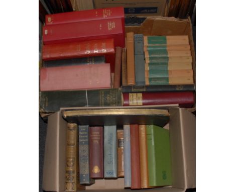

Topography and Genealogy – Yorkshire, Hargrove (E.), The History of the Castle, Town, and Forest of Knaresborough, with Harrogate, and its Medicinal Waters, fifth edition, York: Wilson, Spence, and Mawman, 1798, fold-out map, frontispiece and plates, 18th century style 20th century sheep, 12mo in 6s, (1); Kelly’s Directory of Lincolnshire, 1892, rebound, 4to, (1); Pevsners, various counties, editions, and dates, cloth only, (8); Burke’s Landed Gentry, 1965, 4to, (1); Lodge’s Genealogy of the British Peerage, seventh edition, 1840, later cloth, 8vo, (1); Fairbairn’s Crests, reprint; Year Book and Guide to South Africa, 1950, pictorial boards, 8vo, (1); Oxford University Calendar, 1924, 8vo, (1); Arnold’s Oxford and Cambridge; Gwynn’s Cities of Ireland; etc., [approx. 30]
We found 109182 price guide item(s) matching your search
There are 109182 lots that match your search criteria. Subscribe now to get instant access to the full price guide service.
Click here to subscribe- List
- Grid
-
109182 item(s)/page

Travel - Huxley (Elspeth), The Sorcerer's Apprentice: A Journey through East Africa, first edition, first impression, London: Chatto and Windus, 1948, illustrated with a map and 32 b/w plates, original dustjacket over terracotta cloth, 8vo, (1); Leipnik (F.L.), A History of French Etching [...], Illustrated with a Frontispiece and One Hundred and Six Reproductions in Photogravure, London: John Lane, The Bodley Head Limited, 1924, original cloth over papered boards, 4to, (1); local interest and angling, (2), [4]
![Travel & Literature, Europe - Wright (The Rev. G.N.), The Rhine, Italy, and Greece, [Illustrated] In a Series of Drawing](https://cdn.globalauctionplatform.com/8f09b207-1d82-4f0a-9189-aed900cda020/40946889-3f97-42b7-aed5-aee101258f64/468x382.jpg)
Travel & Literature, Europe - Wright (The Rev. G.N.), The Rhine, Italy, and Greece, [Illustrated] In a Series of Drawings from Nature [...], two-volume set bound as one, first edition, London: Fisher, Son & Co., [n.d., 1841], illustrated with full-page steel-engraved plates, contemporary quarter-calf over marbled boards, 4to, (1); Riviere Binding, Lubbock's Switzerland, London: Macmillan, 1896, illustrated, contemporary half-polished calf gilt over marbled boards, top-edge gilt, others uncut, 8vo, (1); further Swiss scenery, (2); [Conder (Josiah)], The Modern Traveller [...], volume I only: Greece, London: James Duncan, 1826, fold-out map, contemporary green quarter-roan over marbled boards, 12mo, (1); [Chateaubriand (François-Auguste-René), Hugo (Victor), others], Album de la Jeunesse, Paris: Louis Janet, 1831, illustrated with full-page steel engravings, contemporary green cloth over checkered boards, all edges gilt, marbled endpapers, contemporary ink MS inscription, 18mo, (1); Becker (Wilhelm Gottlieb), Taschenbuch zum geselligen Vergnügen, Leipzig: Joh. Friedrich Gleditsch, 1818, engraved frontispiece and title-page, further full-page engraved plates, original green boards, printed with a Neoclassical design, all edges gilt, 18mo, (1); etc., [8]

Travel and Exploration - Petherick (John, F.R.G.S.), Egypt, The Soudan and Central Africa, with Explorations from Khartoum on the White Nile to the Regions of the Equator, Being Sketches from Sixteen Years' Travel, first edition, Edinburgh and London: William Blackwood and Sons, 1861, fold-out map (torn), original publisher's cloth, neat presentation inscription and institute stamp to ffep, 8vo, (1); Selous (Frederick Courteney, C.M.Z.S.), Travel and Adventure in South-East Africa, with Numerous Illustrations and Map, first edition, London: Rowland Ward and Co., Limited, 1893, original publisher's pictorial cloth, 8vo, (1); etc., [3]


World War Two, RAF, Aden Command – 133982 Flight Officer C.H. Meads, 621 Squadron, an attaché case archive collection of ephemera and photographs, including Meads’ officer’s identity card, partial pay and allowances book for 1944, mixed sizes of b/w photographs of fellow RAF personnel, some portraits and informal snapshots, scenes of native domestic life in Aden and Somaliland, a few aerial pictures from reconnaissance missions, etc; pencil annotated flight map; some banknotes and currency; RAF Moncton pennant; etc., [collection]
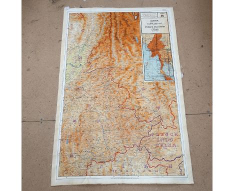
![Africa - Map of Central Africa, London: Edward Stanford, [n.d., c. 1880], hand-coloured eighteen-fold map laid on linen, 55cm](https://cdn.globalauctionplatform.com/8f09b207-1d82-4f0a-9189-aed900cda020/09c6f86c-b09d-45e2-b55c-aee10125fc2e/468x382.jpg)
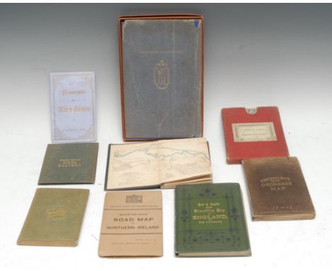
Cartography - five mid-late 19th century cloth bound pocket maps, including Rankin's Eight Miles Round Malvern, Malvern: H.W. Lamb, [n.d., c. 1850], 43cm x 42.5cm, the binding enclosing the Lamb's ticket too, (1); the others including, Ordnance Survey of England Wales, marbled wrappers and slipcase en suite, (1); Cruchley's Reduced Ordnance Map, (1); Rhineland Transport, Carte du Canal de l'Est, (1); Gall & Inglis' New Travelling Map of England, with The Railways, (1); a later Ordnance Survey "Quarter-Inch" Road Map of Northern Ireland, (1); books, including [Coles (Charles Barwell)], Short Whist [...], London, 1855, original cloth, 8vo, (1); Dutton's Photographs of Bath Abbey, [c. 1894], original lavender wrappers, (1); Nonesuch Dickensiana, 1937, original blue cloth, box en suite, 8vo, (1), [9]
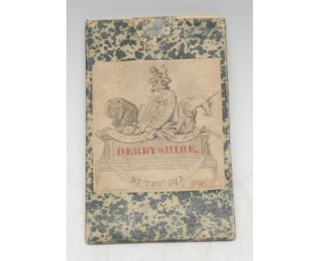
Local Interest - Thomas Dix (fl. early 19th century), A New Map of the County of Derby, Divided into Hundreds, London: Published Dec. 1, 1818, by W. Darton Jun:R, 12-fold, hand-coloured engravings, laid on linen, Darton's advertisement ticket/label to verso, 49.5cm x 41cm, original marble sleeve en suite, [1]

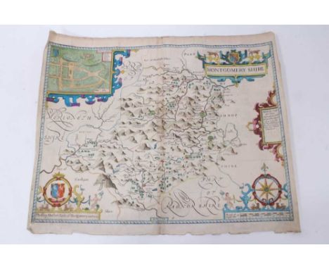
![Robert Morden (c. 1650 - 1703), by, two-page map, Darbyshire (sic, Derbyshire), [Published and] Sold by Abel Swale, Awnfham (](https://cdn.globalauctionplatform.com/8f09b207-1d82-4f0a-9189-aed900cda020/4fbedbc0-a4bc-43bb-bf8c-aee70079814a/468x382.jpg)

Medical, Local Interest, Ransom Wood - Henson & Co of Nottingham, by, a pair of large format sepia photographs, Nottingham & Notts Sanatorium/Sherwood Forest, Patients Playing Croquet and the South Front, signed, titled and inscribed mounts, the photographs 30cm x 38cm, uniformly mounted and framed, 48cm x 59.5cm overall, (2); a 19th century county map, (1), [3]


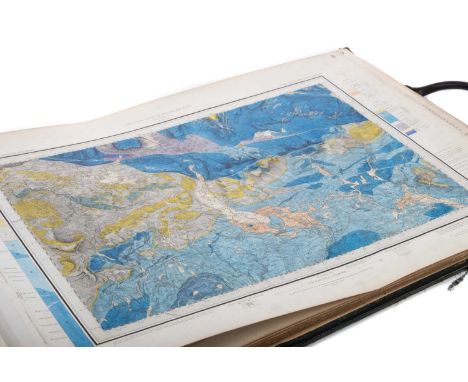
THE GEOLOGICAL SURVEY OF ENGLAND AND WALES,a folio of finely hand coloured geological maps (no. 2 missing), engraved at the Ordnance Survey office, Southampton, variously dated mid-to-late-19th century, all bearing W.H. Milnes printer and stationer, Wakefield stamp, linen backed, each leaf 42cm x 58cmThe sheets are bound into a large folio, the exterior is quite heavily worn and scuffed; the stated scale is ‘Scale of one inch to a Statute Mile’.Page/Map 1 is annotated as ‘Sheet 98 N. E. (New Series Sheet 39)’ but obviously numbered ‘1’ in the top right corner, a Page/Map 2 is missing and resumes at Page/Map 3, annotated as ‘Sheet 98 S. E. (New Series Sheet 49)’, the latest date listed on this map is 1892 relating to certain revisions.The Pages/Maps then proceed numerically according to the numbers printed in bold in the upper right corners #3-30Preceding Page/Map 1 is a partial map of Thirsk and Malton (this torn and discoloured) so a total of 30 maps, 29 (missing Page/Map 2 as stated) are hand coloured geological maps in a numerical series according to the numbers in the upper right.Some example latest listed dates are Page/Map 5 1879, 10 1858, 18 1887, 20 no listed dates, 25 1885, 30 1875.There are marks to the borders of the maps and the leaves as well as some staining, mostly to the backs or ledges of the sheets but occasionally affecting the maps as well as general browning to varying degrees.Additional images illustrating general condition available


§ ALAN DAVIE C.B.E., R.A., H.R.S.A. (SCOTTISH 1920-2014) OPUS G. 2337: MEDITATIONS ON A BABYLONIAN WORLD MAP NO. 3, 1998 Signed and dated upper left, gouache on paperDimensions:33cm x 38cm (13in x 15in)Note: Note: Few British artists of the 20th century are quite as intriguing as Alan Davie. Low key and independent, Davie operated outwith the art world ‘scene’ until his death in 2014 which means that, despite his popularity amongst critics and collectors, he isn’t the household name he perhaps deserves to be. Hopefully this is set to alter; it is with happy serendipity that this sale coincides with a major exhibition of his work at Dovecot Studios, Edinburgh, celebrating the centenary of his birth.He met and was admired by the great collector Peggy Guggenheim in Venice in the late 1940s and was close to members of the American Abstract Expressionist movement including Jackson Pollock.Taking reference points from a vast area of art history - Celtic, Buddhist, African, Hindi and Modernist to name but a few - he created a language of emblems and symbols with the aim of capturing the 'mysterious and spiritual forces normally beyond our comprehension.' Davie’s esotericism and eccentricity earned him the reputation as something of a “shaman”, a fitting title for an artist who sought to live his entire life as an exploration of the magic that underpins art, music and philosophy.The artist has had retrospectives at the Barbican, London, Tate St Ives and Tate Britain. He was appointed CBE in 1972 and elected a senior Royal Academician in 2012.

A small mixed lot of pictures and prints including a miniature silhouette in ebonised framed, a further silhouette inscribed below 'Horatio Nelson' and signed in pencil 'JG', in ebonised frame, a small Victorian rosewood frame containing six wax seal stamps, a framed pot lid 'The Time' (af), a small map for the road from 'Carlisle to Rarwick in the North and East Riding of Yorkshire', 19 x 12cm, an etching of Napoleon Bonaparte, indistinctly signed to the margin, a small print of a harbour scene, indistinctly signed and dated 1853, an early 19th century print of George III by Rosenberg & Son, a print of HMS Britannia entering Portsmouth 1835, a print titled 'The End of An Era', depicting HMS London leaving the Grand Harbour in Malta, all framed and glazed, also a half boat block mounted on a plinth, bearing plaque 'Falmouth Working Boat 1890' (12).


A GEORGE III SILKWORK COUNTIES MAP OF ENGLAND & WALESLATE 18TH OR EARLY 19TH CENTURYIn a verre eglomise slip and gilt frame72 x 64cm overallProvenance: Property removed from 8 Great Pulteney Street, BathPurchased by the vendor from Witney Antiques, November 2000Condition Report: The frame appears laterThis appears partially incomplete, some black stencilled text remains yet to be stitched overWith fadingThe gilt frame with rubbing and wear and unevenness to the gilt, probably later in any case and some of this wear possibly to simulate greater age than it truly possesses Please refer to additional images for visual reference to condition Condition Report Disclaimer

AMERICA AND WEST INDIES, MOLL (HERMAN) (1654-1732), NORTH AMERICAPart hand-coloured, with title cartouche, dedication to "The Right Honourable JOHN, Lord SOMMERS", mounted, framed and glazed68cm high, 107cm wide overallCondition Report: Unexamined out of the frameThere is some staining and foxing to the paper, some marks and some stains, most marks are to the right hand joins in the 'western ocean'. Some creasing to the foldsThe frame with some knocks, scratches, chips, modern frameNo reason to doubt this isn't an 18th century map, it is not a modern reprographic copy (photocopy)Please see additional images for visual reference to conditionCondition Report Disclaimer

THE WORLD, BURGHERS (MICHAEL), A NEW MAP OF THE TERRAQUEOUS GLOBECIRCA 1700 OR LATER A New Map of the Terraqueous Globe according to the Ancient Discoveries and most general Divisions of it into Continents and Oceans, dedicated to William, Duke of Gloucester, hand coloured map, mounted framed and glazedImage size: 37 x 51cmCondition Report: Unexamined out of the frameThere is some staining and foxing to the paper, some marks and some stains, there are larger stains near the word 'GLOBE'The rear has some labels and stickers to the rearSome creasing to the foldsThe frame with some knocks, scratches, chipsPlease see additional images for visual reference to conditionCondition Report Disclaimer


Of Jack the Ripper interest: Victorian sepia photograph, purported to be of Mary Kelly, inscribed and dated 1898 (sic), 16 x 20cm in glazed frame. NB: Mary Kelly (1863-1888) is widely believed to have been Jack the Ripper's last victim. The photograph is from a local private collector. The image would appear to be very similar to images on line of Mary Kelly, please form your own opinion. We have not taken the photograph out of the frame. The photograph is definitely Victorian although the map to the reverse is a modern facsimile which raises obvious doubts about the authenticity. We do not know whether it is genuine, again please form your own opinion.
John Speede (after Saxton) - Montgomerieshire, hand coloured engraving, 1610 first edition, English descriptive text verso, 39 x 48cm, together with Nicholas Sanson - La Gaule en quartre Regions - France in Roman Times, hand coloured engraving, 41 x 51cm and Herman Moll - hand coloured early 18th engraved map of Westmorland together with another of Durham, 21 x 33cm. (4)
-
109182 item(s)/page