We found 109198 price guide item(s) matching your search

Refine your search

Year

Filter by Price Range
  • List
  • Grid
  • 109198 item(s)
    /page

Lot 518

Administrative map of the British Railways by John Bartholomew, framed 85 x 73cm (af)

Lot 751

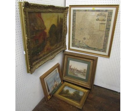
CM Holland (Late 19th century British school) - River scene with figures, watercolour and bodycolour on paper, signed and dated 1892 and inscribed Part Copied, 22 x 27cm, together with a late 19th century oil painting on canvas of a garden scene with water pump and cat, signed Alfred Parsons, 45 x 59.5cm approx, also together with further oil on board of a landscape with cottage, an oil on board of an 18th century style marine battle scene and an 18th century map of Oxfordshire dedicated to the Bishop of Oxford by RP, 50 x 48cm approx, various sizes, all framed (5)

Lot 813

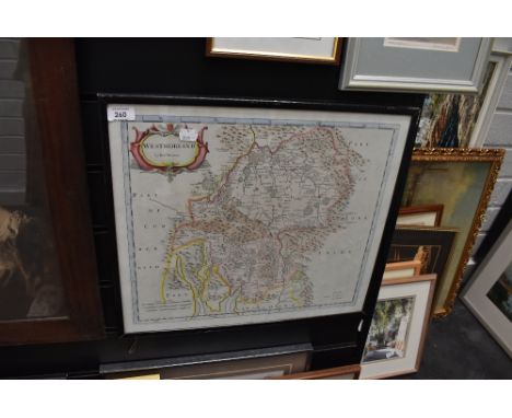
A 19th century map of the county of Gloucester by C & J Greenwood, published 1851, 60 x 68.5 cm approximately, together with a Cruchley's road and railway map of the county of Middlesex, 46 x 54.4 cm, framed set of Wills cigarette cards from the Old Inns Series together with a John Player Derby & Grand National Winners Series cigarette card set, one other reproduction set of cricketing cards, etc, all framed (7)

Lot 815

A collection of 19th century and later pictures including a map of Warwickshire published by Henry Teesdale, small collection of 19th century botanical engravings and topographical views including two engravings of Badminton, signed black and white etching by Anthony Hill - Babbicombe (sic), a 19th century framed invoice from Dauncey & Turner - Wickwar, dated 1880, etc, together with a mahogany framed mirror in the Georgian manner and a reproduction Thames Nauticalia brass cased clock/barometer/thermometer, on a wooden plaque (collection)

Lot 1802

Including old colored, including 7 Provencie, largest map is 65 x 50 cm.

Lot 1805

Including Grolla, largest map is 63 x 53 cm.

Lot 1808

Including old colored and Brabant map, largest map is 52 x 62 cm.

Lot 1817

Including old colored maps, including map of Antwerp, largest map is 67 x 65 cm.

Lot 1820

Including old colored maps, including map of Brabantia, largest map is 51 x 60 cm.

Lot 1823

Including old colored maps, including map of Biesbos, largest map is 97 x 56 cm.

Lot 1826

Including old colored maps, including map of Brabant, largest map is 80 x 50 cm.

Lot 1832

Including old colored maps, including map of Belgie, largest map is 55 x 48 cm.

Lot 1835

Including old colored maps, including map of Brabantia, largest map is 93 x 59 cm.

Lot 1838

Including old colored maps, including map of Gelderland, largest map is 93 x 61 cm.

Lot 1841

Including old colored maps, including map of Brabant, largest map is 53 x 64 cm.

Lot 1847

Including old colored, including map of Brabant, largest map is 80 x 50 cm.

Lot 1850

Including old colored, including map of Brusserl, largest map is 83 x 52 cm.

Lot 1853

Including old colored, including map of Beleg and Bergen op Zoom, largest map is 33 x 52 cm.

Lot 1856

including map of the world, largest map is 51 x 31 cm.

Lot 1862

Including old colored, including map of the Brabantia, largest map is 58 x 43 cm.

Lot 1865

Including pedigree of Oranje Nassau, largest map is 41 x 55 cm.

Lot 1868

Including old colored maps, including map of Bergen op Zoom, largest map is 58 x 37 cm.

Lot 1871

Including map of Bergen op Zoom, largest map is 39 x 52 cm.

Lot 1873

Including old colored maps, including map of Brabantia, largest map is 53 x 43 cm.

Lot 1874

Including old colored maps, including map of Brabantia, largest map is 52 x 41 cm.

Lot 1875

Including old colored maps, including map of Bergen op Zoom, largest map is 53 x 41 cm.

Lot 1876

Including old colored maps, including map of Bergen op Zoom, largest map is 54 x 44 cm.

Lot 1877

Including old colored maps, including map of Bergen op Zoom, largest map is 55 x 38 cm.

Lot 1878

Including old colored maps, including map of Antwerpen, largest map is 55 x 40 cm.

Lot 1879

Including old colored maps, including map of Bergen op Zoom, largest map is 58 x 43 cm.

Lot 1880

Including old colored maps, including map of Bergen op Zoom, largest map is 40 x 53 cm.

Lot 1881

Including old colored maps, including map of Bergen op Zoom, largest map is 54 x 42 cm.

Lot 1882

Including old colored maps, including map of Schelde, largest map is 53 x 40 cm.

Lot 1883

Including old colored maps, including map of Breda, largest map is 52 x 40 cm.

Lot 1884

Including old colored maps, including map of Steenbergen, largest map is 34 x 26 cm.

Lot 1885

Including old colored maps, including map of Brabant, largest map is 36 x 27 cm.

Lot 1886

Including old colored, including map of Bergen op Zoom, largest map is 30 x 22 cm.

Lot 1887

Including old colored, including map of Breda, largest map is 38 x 29 cm.

Lot 1888

Including old colored, including map of Zeeuws Vlaanderen, largest map is 35 x 27 cm.

Lot 1889

Including old colored, including map of Antwerp, largest map is 34 x 29 cm.

Lot 1890

Including old colored, including map of Brabant, largest map is 33 x 30 cm.

Lot 1891

Including map of Zeeland, largest map is 30 x 20 cm.

Lot 1892

Including map of Bergen op Zoom, largest map is 29 x 20 cm.

Lot 1893

Including map of Bergen op Zoom, including old colored map, largest map is 33 x 27 cm.

Lot 1894

Including map of Bergen op Zoom, including old colored map, largest map is 36 x 29 cm.

Lot 1895

Including map of Bergen op Zoom, including old colored map, largest map is 32 x 24 cm.

Lot 1896

Including map of Brabant, including old colored map, largest map is 18 x 31 cm.

Lot 1897

Including map of Brabant, including old colored map, largest map is 21 x 27 cm.

Lot 1898

Including map of Brabant, including old colored map, largest map is 28 x 19 cm.

Lot 1899

Including map of s Hertogenbosch, including old colored map, largest map is 38 x 29 cm.

Lot 1900

Including map of Brabant, including old colored map, largest map is 38 x 30 cm.

Lot 1901

Including map of Brabant, including old colored map, largest map is 32 x 25 cm.

Lot 1902

Including map of Brabant, including old colored map, largest map is 32 x 24 cm.

Lot 1903

Including map of Bergen Op Zoom, largest map is 24 x 34 cm.

Lot 4075

Walt Disney's Disneyland Quad poster / map, (1970s), folded, 30 x 40 inches.

Lot 861

A Map of the Country 11 Miles around the City of Bristol by H Donn, dated 1778, original price 5 Shillings, later coloured, size 48cm x 48cm, folded , named to reverse

Lot 260

A vintage map of Westmorland by Robert Morden. 48cm by 42cm approx.

Lot 9

Collection of twelve enamel boxes, Bermuda Heritage Series, to include Tom Moore's Tavern, a map of Bermuda by John Speed, The Gombey Dance, Gibbs Hill Lighthouse, a Bermuda Buttery etc., housed in Halcyon Days, Royal Worcester and Crummles boxes, (12)

Lot 254

Tin Michelin Map SignMake: Contact AuctioneerModel: Contact AuctioneerYear: 0Mileage: 0VIN: Contact AuctioneerConfiguration: Right Hand DriveRegistration: Contact AucitoneerTransmission: Contact AuctioneerTin Michelin Map Sign The buyers premium for automobilia items, including registration numbers is 15% plus VAT (18% in total)

Lot 08

Tin Michelin Map SignMake: Contact AuctioneerModel: Contact AuctioneerYear: 0Mileage: 0VIN: Contact AuctioneerConfiguration: Right Hand DriveRegistration: Contact AucitoneerTransmission: Contact AuctioneerTin Michelin Map Sign The buyers premium for automobilia items, including registration numbers is 15% plus VAT (18% in total)

Loading...Loading...
  • 109198 item(s)
    /page

Recently Viewed Lots