We found 109198 price guide item(s) matching your search

Refine your search

Year

Filter by Price Range
  • List
  • Grid
  • 109198 item(s)
    /page

Lot 26

MAPS: SAXTON: A Map of Suffolk, corrected and amended with many additions… C1720, with a fold in the middle. Please find enclosed a copy of a letter from the British Museum expert about it and one other map of Suffolk and their rarity, (54 x 44 cm).From the Paul Bentley collection of maps and atlases.

Lot 27

MAP: SMITH: A new Mapp of the county of Suffolk with the post and cross roads and other remark according to the latest and best observations, Smith/Dicey & co. no date, c1707-51, Please find enclosed a copy of a letter from the British Museum expert about it and one other map of Suffolk and their rarity (54 x 44 cm)From the Paul Bentley collection of maps and atlases.

Lot 3

MAP- Hertfordshire- Speed, John: Hartford Shire described the sittuations of Harford, and the most ancient towne S. Albons with such memorable actions as have happened. John Sudbury & George Humblell, c 1646. Hand coloured, mounted, framed & glazed, 39.5 x 51.5cm.

Lot 30

SUSSEX Map: FADEN, W: A topographical map of the county of SUSSEX, divided into Rapes, Deaneries & Hundreds, planned from an actual survey by a scale of one inch to a mile. Begun by W. Gardner and the late T. Yeakell, Completed by Thos. Gream, William Faden, 4 June 1795. Hand coloured, linen backed and folding, with a cont. slipcase, rubbed (195 x 92 cm)From the Paul Bentley collection of maps and atlases.

Lot 31

FADEN, William (publisher): A Plan of His Majesty's Forest, called The New Forest, in the County of Southampton laid down from Surveys taken by Thos. Richardson, Wm. King, and Abm. And Wm. Driver, [London], William Faden, 1789. Large hand coloured, linen backed and folding, together with the Index map, also dated 1789. Housed in a cont. full leather box; rubbed.

Lot 32

MAP: Ortelius, A: Cambriae Typus Auctore Humfredo Lhuydo. No date, hand coloured, mounted, glazed and framed (36.5 x 48.5cm)From the Paul Bentley collection of maps and atlases.

Lot 33

MAPS: COLBY, Col: Map of Cambridgeshire. Engraved by B. Baker, 1834. Linen backed, folding with marbled ends and slipcase. (150 x 140cm); COLBY, Col: Map of Northamptonshire, Bedfordshire, Hertfordshire & Buckinghamshire, 1823, this Electrotyped 1872. Hand coloured, linen backed and folding with cloth ends, (179 x 127cm); LEA, P (corrected): MAP of the county of Northamptonshire, together with ye three small counties of Bedford, Huntington & Rutland. With 5 inset plans & 2 shields, C1693. (56 x 46cm); Northamptoniae Comitatus Descriptio..… no date, c1675. Cropped, with no borders (47.5 x 36.5cm). (4)From the Paul Bentley collection of maps and atlases.

Lot 34

GREENWOOD: Map of the County of Kent, from an actual survey made in the years 1819 & 1820, published by G. Pringle, July 19, 1821. Engraved by Neele & Son. Hand coloured, linen backed and folding (176 x 115 cm)From the Paul Bentley collection of maps and atlases.

Lot 344

CARY’S New Guide for ascertaining Hackney Coach Fares. 1801. With a large folding hand-coloured Map. Later half leather, VG; Cary's new itinerary: the Great roads, both direct & cross throughout England & Wales.. 1815, 6th. Edn. With 7 folding maps (including the frontis). Later full leather; Restored copy; Pattisons Cyclists Road Maps: Nine Maps in a specially made clamshell box. Each map with pictorial verso and folds into the original covers, c1890; Lett's Cycling maps of England and Wales, 1884. Large folding map with a specially made clamshell box. Tears to the folds; Howard, C: The roads of England & Wales; an itinerary for Cyclists, tourists & travellers. Letts, Son & Co. 1884, 4th. Edn. 423pp Plus numerous illustrated adverts. Original boards gilt. Lacking the map? (5)

Lot 351

ESSEX: Morant, P: The History & Antiquities of the County of Essex, Two Volumes. T. Osborne; etc. 1768 & 1763. With numerous maps and plates, many folding. Folio, cont. full calf; Excursions in the county of Essex. In Two volumes. Longman, et al, 1818-19, 1st. Edns. Near cont. half leather. VG; White, W: History, gazetteer, & directory of the county of ESSEX. 1863, 2nd edn. As usual, Lacking the map. Cont. full leather, rebacked; County biography: or the lives of… in Essex, Suffolk & Norfolk. Witham & Maldon, for P Youngman, 1825, 1st. Edn. With 68 portraits. Cont. half leather, rubbed. (6)

Lot 354

RIVERS: Crowquill, Alfred: A Guide to the Watering Places. Harwood, no date (1839). PP: 50, (x) adverts, with a frontis plus 16 plates. Later cloth backed marbled boards; Progress and Commerce, 1894: Rivers of the North. 4to. 264pp, illustrated throughout. Original cloth gilt. Inner hinges cracked; JEFFREYS, John: A new map of all the rivers of England & Wales, traced from the springs into the sea, Sept 14, 176? Hand coloured, linen backed and folding (125 x 120 cm). Rare. (3)From the Paul Bentley collection of maps and atlases.

Lot 37

FENS MAP: WELLS, Samuel: The Great Level of the Fens Called Bedford Level. Cary, the Fen office, 27 March, 1829. Hand coloured, linen backed and folding with marbled paper to one end. (80cms square). Small tear to one fold.From the Paul Bentley collection of maps and atlases.

Lot 387

Holy Bible: Old and New Testament, together with the Common Prayer book & the Book of Psalms. Barker, 1679-1708. Lacking the title page for the Old testament, and with only one large folding map (loose). Cont. full leather, lacking the clasps. SOLD WITH ALL FAULTS.

Lot 4

MAP- Derbyshire- Speed, John: Darbieshire described 1610. John Sudbury & George Humblell, c 1627. Hand coloured, mounted, framed & glazed, 42 x 53cm.

Lot 41

BRADSHAW, G: Map of Canals, Navigable Rivers, Railroads etc. of the Midland Counties of England from Actual Survey,.. Manchester, A Prentice, 1829, engraved and printed by W R Gardner. (132 x 129 cm). Hand coloured, linen backed and folding with silk piping trim, and a 20pp Appendix booklet in full leather, both housed in the original full calf box, VGFrom the Paul Bentley collection of maps and atlases.

Lot 45

LOADER’S Scientific & Commercial Map of England and Wales in which are delineated the canals, rail-roads & navigable rivers, the extent of the navigation of each river with the elevations of the canals, together with the geology and principal situations of mineral productions. W. Day, 1831, 1st. edn. (138 x 112 cm)From the Paul Bentley collection of maps and atlases.

Lot 46

MAPS: BARTHOLOMEW, J: The Imperial Map of England & Wales, according to the ordnance survey with the latest additions, shewing clearly every feature of roads, canals, rivers, gentlemen's seats, & c. Scale 4 miles to an inch, published by A Fullarton & Co, No date. 18 sections, 1-15 measuring 74 x 54 cm, and 16 a,b,&c 74 x 27 cm. Hand coloured, linen backed and folding; plus a folded index sheet (tears to folds). Housed in the original slipcase, rubbed and with tears. The map is clean; Blofeld & Co: Map of Great Britain, with "Continuation of Scotland". Hand coloured, linen backed & folding, with cloth ends and matching slipcase, (120 x 92 cm); MALBY'S Map of the stars visible in Great Britain and Ireland, reduced to the year 1850, compiled from the globes under superintendence of Diffusion of Useful knowledge. Hand coloured, linen backed and folding into the original fold-around boards, spine of covers torn (49 x 48 cm); SDUK MAP: Geological Map of England and Wales. Chapman & Hall, 1843 (40 x 34 cm). (4)From the Paul Bentley collection of maps and atlases.

Lot 47

Gillray (James). A New Map of England & France. The French Invasion. Or John Bull bombarding the Bum-Boats. H. Humphrey Nov 5th 1793 [but H. G. Bohn edition, circa 1851], Hand coloured, mounted, framed & glazed, 30.5 x 25cm

Lot 48

MAPS: COLTMAN, Nath: New Map of South Wales. Laurie and Whittle, 1st. Jan 1798, 4th. Edn. With considerable additions… to 1807. Linen backed, folding & with slipcase (72 x 55 cm); MAP OF Randor Brecknock, Cardigan & Carmarthen shires. Hand coloured, with repair and strengthened from the back (48 x 37 cm); WALES: Cambriae Typus Auctore Humfredo Lhuydo, with Latin text to verso, Over Cleaned! Hence hard to tell the age! With a middle fold (54 x 44 cm); & Oliver & Boyd's Travelling Map of Scotland, with the distances on the great road.. Edinburgh, no date (1821). PP: (iv), 56 (made up of double and single page hand coloured maps), (I) blank, 10 (principal roads), (I) Table, (I) blank. Cont. leather backed boards. Rare. (4)From the Paul Bentley collection of maps and atlases.

Lot 5

MAP: SPEED, J: The Kingdome of Great Britaine and Ireland. (1653). Hand coloured, mounted, framed & glazed (39 x 52cm)

Lot 54

The THAMES: 1- Taunt, H W: A new map of the River Thames from Oxford to London. No date, 5th. Edn. With a photographic frontis, 2 plates, a folding table, plus 33 double page maps with 101 Albumen photos. 215pp. Original brown pictorial cloth gilt; covers torn and almost detached; 2- FEARNSIDE, W G: Eighty picturesque views on the Thames and Medway, engraved on steel. Black & Armstrong, no date, C1834 (Price Two Guineas). (2)From the Paul Bentley collection of maps and atlases.

Lot 55

Taunt, H W: A new map of the River Thames from Oxford to London. No date, 3rd. Edn. (1879). With a frontis, general map of the Thames, plus 33 double page maps with 100 Albumen photos. 215pp. Original pictorial cloth gilt; rubbed and hinges cracked.From the Paul Bentley collection of maps and atlases.

Lot 56

Taunt, H W: A new map of the River Thames from Oxford to London. Oxford, (1872) preface dated, 1st. edn. With 24 colour maps and 79 small albumen photographs of the Thames (Although the title calls for 80, it is issued with space for only 79), hence complete. 66pp (including index & adverts). Oblong 8vo. Original green cloth gilt. Recased with new endpapers.From the Paul Bentley collection of maps and atlases.

Lot 57

LONDON MAP: GREENWOOD, John & Christopher: Map of London from Actual Survey Made in the Years 1824, 1825 & 1826. Published August 21. 1827, first edition. Contemporary hand colouring, linen-backed with silk pipe trim and folding. 185 x 147cm, with inset views of Westminster Abbey and St Paul's Cathedral. Housed in the original full tree calf box, VGFrom the Paul Bentley collection of maps and atlases.

Lot 58

LONDON MAP: GREENWOOD, John & Christopher: Map of London from Actual Survey Made in the Years 1824, 1825 & 1826. Published August 21. 1827, first edition. Contemporary hand colouring, linen backed with silk pipe trim and folding. 185 x 147 cm, with inset views of Westminster Abbey and St. Paul's Cathedral. Housed in the original full leather box, VGFrom the Paul Bentley collection of maps and atlases.

Lot 59

Cary's Survey of the High Roads from London to Hampton Court... With the number of inns & turnpikes. J Cary, July 1st, 1790. 1st. Edn. With a double-page hand-coloured general map, hand-coloured general Plan, Plus 80 hand-coloured numbered routes, on 40 pages. Later half leather over marbled boards; John Towneley's Armorial bookplate to front pastedown, VGFrom the Paul Bentley collection of maps and atlases.

Lot 6

MAP: SPEED, J: The Kingdome of England. c1646. Hand coloured, mounted, framed & glazed (39.5 x 52cm)

Lot 61

LONDON MAP: Cary's New and Accurate Plan of London and Westminster, the Borough of Southwark and parts adjacent: viz. Kensington, Chelsea, Islington, Hackney, Walworth, Newington &c with an Alphabetical list of upwards of 500 of the most principal streets with references to their situation, Jan 1, 1806, Linen backed, folding & with some hand colouring. tears to folds (125 x 82 cm).From the Paul Bentley collection of maps and atlases.

Lot 66

LONDON MAP: Wyld, James: New Plan of London and its vicinity, 1870, Hand coloured, linen backed and folding into the original covers- rubbed & stained, but map clean (117 x 78 cm)From the Paul Bentley collection of maps and atlases.

Lot 67

WYLD, James: An Atlas of London and its Environs. No date, c1849, Elephant folio (43.5 x 31 cm). Title page (with an index map), plus 9 double-page Plans with contemporary hand-colouring, 5 & 6 are joined together to make a full plan of London, measuring: 80 x 42 cm. Original cloth with leather label to upper cover. Later spine and new endpapers; covers a little smudged, internally very clean. A rare survivor!From the Paul Bentley collection of maps and atlases.

Lot 72

LONDON: MAITLAND, William: The History of London from its Foundation to the Present Time, two volumes of text plus an Atlas volume. T Osborne & J Shipton, 1756. Folio, PP: V1- Frontis, viii, 712; V2- Title page, 713-1410, followed by: Contents, Appendix & Subscribers' list; V3- 122 Plates, map & plans (many folding), (ii) direction to binder). Later half leather with cont. marbled boards (3)From the Paul Bentley collection of maps and atlases.

Lot 75

LONDON MAP: Edward: Mogg's New Plan of London, Jan 1st. 1836. Hand coloured, linen backed, folding with grey card ends & the original slipcase with label (91 x x 56.5 cm).From the Paul Bentley collection of maps and atlases.

Lot 76

LONDON MAP: Edward: Mogg's strangers guide to London, exhibiting all the various alterations & improvements complete to the present time, Jan 1st, 1837. Hand coloured, linen backed, folding & with the original slipcase. (59.5 x 51 cm).From the Paul Bentley collection of maps and atlases.

Lot 77

LONDON MAP: MOGG, Edward: An Entire New Plan of the Cities of London & Westminster with the Borough of Southwark, Comprehending the New Buildings and other Alterations, to the time, 1814. Hand coloured, linen backed, folding & with the original slipcase, rubbed. (90 x 48 cm).From the Paul Bentley collection of maps and atlases.

Lot 78

LONDON Map: Mogg (Edward): New Map of the country Twenty-Four Miles Round London, July 1st, 1809. Hand coloured, linen backed and folding, with the original slipcase- which has tears, (62 x 59 cm).From the Paul Bentley collection of maps and atlases.

Lot 8

SPEED, John: MAP OF WALES. 1610, hand coloured, mounted, glazed and framed (38.5 x 51cm)From the Paul Bentley collection of maps and atlases.Condition ReportDear Mrs Forwood,The tape does cover small holes on the map.RegardsFrank

Lot 81

DAW, Edmund: Map of the Parish of St Pancras in the County of Middlesex 1854. Hand coloured, linen backed and folding into the original covers, tears to covers (160 x 74 cm)From the Paul Bentley collection of maps and atlases.

Lot 82

DAW, Edmund: Map of the Parish of St Pancras in the County of Middlesex 1860. Hand coloured, linen backed and folding into the original covers, rubbed (160 x 74 cm)From the Paul Bentley collection of maps and atlases.

Lot 83

LONDON MAP: FADEN, W: MAP of the country Twenty-Five Miles Round London, planned from a scale of one mile to an inch. 1815, 3rd. Edn. Hand coloured, linen backed and folding with a cont. marbled slipcase, (130 x 106 cm).From the Paul Bentley collection of maps and atlases.

Lot 84

LONDON Map: FADEN, W: MAP of the country Twenty-Five Miles Round London, planned from a scale of one mile to an inch. 1790. Hand coloured, linen backed and folding with a cont. slipcase, which has tears, (130 x 105 cm).From the Paul Bentley collection of maps and atlases.

Lot 85

LONDON Map: Faden (William): A New Topographical Map of the Country in the Vicinity of London, Describing all the New Improvements, Metropolitan Boroughs And Parish Boundaries.. Published By James Wyld, Successor To Mr. Faden, 1840. Hand coloured, linen backed and folding with endpaper adverts and the original slipcase, with label to upper cover, VG (82 x 82 cm).From the Paul Bentley collection of maps and atlases.

Lot 86

LONDON Map: Faden (William): A New Topographical Map of the Country in the Vicinity of London, Describing all the New Improvements, Metropolitan Boroughs And Parish Boundaries.. Published By James Wyld, Successor To Mr. Faden, 1836. Hand coloured, linen backed and folding with endpaper adverts and the original slipcase, with label to upper cover, VG (82 x 82 cm)From the Paul Bentley collection of maps and atlases.

Lot 87

STANFORD'S Geological Map of London, shewing superficial deposits, Compiled by J.B. Jordan, August 1st. 1891, 3rd. Edn. Hand coloured, linen backed, folding into the original covers (66 x 61 cm).From the Paul Bentley collection of maps and atlases.

Lot 88

LONDON MAP: STANFORD'S Library Map of London and its Suburbs, No date, C1862, With 18 of 24 parts, on three of four sheets, Hand coloured, Linen backed and folding with marbled ends. 6 inches to the Mile, each sheet measuring 96 x 87 cm (3)From the Paul Bentley collection of maps and atlases.

Lot 89

LONDON MAPS: STANFORD, E: A Map of the Environs of London extending Twenty-Five Miles from the Metropolis. No date, C1882. Hand coloured, linen backed and folding into the original fold-around covers, (96 x 92 cm); Plus: Bowles's Environs of London taken from actual surveys exhibiting all the new Roads, Parks, Seats of the Nobility &c., to the present year (1777). Hand coloured, linen backed and folding (85 x 64 cm). (2)From the Paul Bentley collection of maps and atlases.

Lot 90

STANFORD'S Library Map of London and its Suburbs, 1877, Original 24 hand coloured folding sheets (46.5 x 39.5 cm each), scale of 6 inches to a mile. Original cloth backed boards, label to upper cover, lacking the ties.From the Paul Bentley collection of maps and atlases.

Lot 91

STANFORD'S Library Map of London and its Suburbs, No date, C1862. Original 24 folding sheets (46.5 x 39.5 cm each), scale of 6 inches to a mile. Original cloth backed boards, label to upper cover, lacking the ties.From the Paul Bentley collection of maps and atlases.

Lot 92

STANFORD'S Library Map of LONDON and its Suburbs, No date, C1862. Large engraved map with hand colouring, on four sheets, each dissected, linen-backed and folding with marbled ends, also each with a label: North West, South West, North East, & South East. 6 inches to the Mile, each sheet measuring 96 x 87 cm. Housed in the original leather box, with the date: 1862 to the spine. VG.From the Paul Bentley collection of maps and atlases.

Lot 93

STANFORD'S Library Map of LONDON and its Suburbs, No date, C1862. Large engraved map with hand colouring, on four sheets, each dissected, linen-backed and folding with marbled ends. 6 inches to the Mile, each sheet measuring 96 x 87 cm. Housed in a full leather box. VG.From the Paul Bentley collection of maps and atlases.

Lot 97

LONDON: SHEPHERD, T H: London and its Environs in the Nineteenth Century Illustrated by a Series of Views. 2 volumes- the numbering is only on the spines and not the title pages. V1- Jones, 1829, & V2- Metropolitan improvements.. Jones, 1827. All plates are present. 4to. Matching cont. half leather and marbled boards; rubbed. VG; Leigh's New Picture of London. 1818. PP: 529, (I)b, 36 (index), (x) general index, 12 (adverts). With a frontis, folding map Plus 11 folding plates. Later full leather; Views in London: Consisting of the most Remarkable Buildings with an Historical description of each. R Miller, nd (Map dated 1819). Illustrated with 26 engravings plus the map. Cont. leather backed boards. (4)From the Paul Bentley collection of maps and atlases.

Lot 98

MAPS: Ordnance Survey Map of London & its environs, 1861. Linen backed and folding into cloth covers (114 x 68 cm); Two Ordnance survey maps: 1- #57, Tiegaron, electrotyped 1864 (96 x 60 cm); 2- North West sheet, electrotyped, 1853 (96 x 60 cm), both in one slipcase. (3)From the Paul Bentley collection of maps and atlases.

Lot 381

A 19th century leather bound photograph album with mechanical music catch, together with a small quantity of 19th century and later maps, to include The District Map of Greater London, London North West Map, Ordnance Survey map, German Nazi Luftwaffe map and a London Nord map.

Lot 500

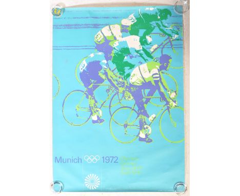
Three original 1972 Munich Olympic Games lithographic posters. The first depicting Munich Olympics Hurdles designed by GAEBELE, Albrecht. München 1972, signed in the plate. Marked FOTO; Albrecht Gaebele, 07.70.0/A, Printed in Germany by Franzis-Druck, München. The second depicting Munich Olympics Sprint race designed by Otl Aicher, Marked FOTO; Longines, 07.71.36, Printed in Germany by Gerber, München. The third depicting Munich Olympics cycling race designed by Otl Aicher, marked FOTO; Longines, 07.71.51A, Printed in Germany by Franz Rehm Verlag, München. Along with nine original entry tickets for Football, Athletics, Handball & Wrestling. Includes multiple literature to include Olympia in Munich official issue for the Olympic city of Munich magazine, aerial view of the Olympic park for competition sites fold out coloured map, Olympics 72 Munich official British Olympic association preview of the XXth Olympiad magazine, Olympia information fold out map, official fold out programme for stadium plans and events timetable, 22 x postcards - text to reverse on one reads "Unfortunately, the Arab/Israeli incident has suspended all proceedings for today and late this afternoon, the army were moving in - all complicated by some half a million spectators." Along with an original stainless steel badge. Largest Poster Measures. 

Lot 698

18th CENTURY MAP OF ASIA NOVA coloured engraving later frame

Lot 156

A 1950s British Rail Railway Map by Waterlow and Sons Showing Great Britain Railway Layout, 63cms by 100cms, SOme Water Damage to Back

Lot 172

A Framed and Glazed Map, Johnson's Africa, 59x74cms

Lot 695

A continental colour lithographic map , 60 cm x 50 cm

Lot 372

An Elizabeth II etched silver map of Great Britain published by the Council for the Protection of Royal England, 55 x 36cm, maker D/M, London 1978, framed Good condition, unexamined out of frame

Lot 413

An Elizabeth II etched silver Royal Geographical Society map, 37 x 56cm, by John Pinches Ltd, London 1977, framed, certificate (2) Good condition

Lot 13

Flamsteed, John. Atlas céleste. Seconde édition. VIII, 40 S. Mit 30 doppelblattgroßen Kupferstichkarten. 22 x 15 cm. Halbleder d. Z. (mit zwei ausgebesserten Fehlstellen am RGelenk und oberes Kapital mit Fehlstelle) mit goldgeprägtem RSchild. Paris, François-Guillaume Deschamps, 1776.Warner, Sky explored 84,1. Shirley C. Flam 1-a Anm. Roller-G. I, 402. Nederl. Scheepvaart Mu. I, 645. Vgl. DSB V, 22f. - Erste Fortin-Ausgabe des berühmten Himmelsatlas'. Das englische Original war 1729 erschienen. Die vorliegende Ausgabe wurde um zwei Karten erweitert und im Format verkleinert. "The first 26 [maps] are centered on major constellations visible from Greenwich; the 'extra' map published by Fortin depicts Corvus and the rear half of Hydra, which were omitted from Flamsteed's 'Atlas Coelestis'. For Sharp's northern and southern hemispheres Fortin substitued those of Le Monniert; and he added Lacaille's map of the southern stars and a map for the alignments of the principal northern ones" (Warner). - Mit Exlibirs auf dem Vorsatz. Leicht stockfleckig (Darstellung kaum betroffen) sonst wohlerhaltenes Exemplar.

Loading...Loading...
  • 109198 item(s)
    /page

Recently Viewed Lots