![[Wavell, Field-Marshall A. P.]. Notes on Infantry Tactics & Training by Lieutenant-Gen. Sir G. M. Harper, 2nd edition, 19](https://cdn.globalauctionplatform.com/0e340770-eaaa-491f-b03e-add000d303e1/529b04b9-09e2-4b27-ad7e-add600d785ed/468x382.jpg)

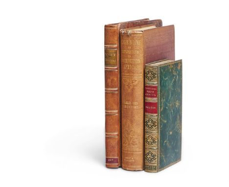
[Wavell, Field-Marshall A. P.]. Notes on Infantry Tactics & Training by Lieutenant-Gen. Sir G. M. Harper, 2nd edition, 1921, several monochrome plates after photographs, folding map in pocket at rear, bookplate of A. P. Wavell to front pastedown, and with ownership inscription to front endpaper A. P. Wavell, Aug 1921, original blue cloth, a little rubbed, together with Fedden (Marguerite). From an Abbeville Window (1918-19), 1st edition, Bristol, J. W. Arrowsmith, 1922, several monochrome plates after photographs, authors presentation inscription to half-title 'with grateful thanks for kind help. Marguerite Fedden', original cloth-backed boards with printed paper labels to spine and upper cover, lightly rubbed, plus Montgomery (D. H.). Down the Flare path, 1st edition, John Hamilton, circa 1920, monochrome illustrations by Stanley Orton Bradshaw, original black cloth, very slightly rubbed, in frayed and slightly chipped dustwrapper, with ownership inscription to front endpaper of F. N. Chapple Coombe Dingle, Broadway, Letchworth (101 Squadron BEF10.12.17-12.6.18)', and two others on the First World War aviation: War Birds, diary of an unknown aviator, circa 1927, mounted portraited photograph of R. M. Groves to front pastedown and R.M. Groves memorial prize label to front pastedown, awarded to cadet C. E. St.J. Beamish, and dated December 1927, original blue cloth gilt, rubbed and some marks, and Sixty Squadron R.A.F., A History of the squadron from its Formation, by Group-Captain A. J. L. Scott, 1920, original blue cloth gilt, a little rubbed, all 8voQty: (5)
We found 109198 price guide item(s) matching your search
There are 109198 lots that match your search criteria. Subscribe now to get instant access to the full price guide service.
Click here to subscribe- List
- Grid
-
109198 item(s)/page


Middlesex/ Hertfordshire/ London Maps: A collection of maps, 18th century and later, including examples by: Robert Morden, G.W. Bacon, J. Harrison, Richard Blome, Robert Morden, J. Cary, Thomas Badeslade & William Henry Toms, together with two James Clarke Lake District related maps (qty)Condition: All in used/ worn condition. Maps include: G.W. Bacon - Hampstead Heath/ Primrose Hill/ Golders Green/ Childs Hill - losses to all edges applied to card.G.W. Bacon - Finchley/ Hendon/ East End - fold lines, applied to board, appears losses to all edges.Richard Blome - A Map of the County of Middlesex - handcoloured, foxed, staining to edges and fold to centre line. Robert Morden - Hertfordshire - Handcoloured, overall good condition, fold line to centre, staining, foxing, left edge possibly trimmed, tape to verso vertical fold. Thomas Badeslade & William Henry Toms - Middlesex - stained, foxed, vertical fold, taped to reverse, tape residue to corners on reverse, paper losses to lower edge, tear to vertical fold. J. Cary - Middlesex - Staining throughout, minor foxing, losses particularly to lower edge and corners, vertical fold line.John Harrison - A Map of Middlesex - folded, some staining and foxing otherwise good condition. Illustrated London News - Map of the London Postal District - Dated 1857 - trimmed page from newspaper - tears to edges, staining and foxing. Middlesex map - Bookplate - some staining and shadow text from page. Five loose bookpages relating to a Survey of the Lakes.James Clarke - Map - Southern Part of the Lake Windermere - Losses and tears throughout, staining visible particularly to edges. James Clarke - Map of Derwentwater and its Environs - Pencil inscription - staining losses and tears throughout.

Benjamin Cole (1697-1783) A set of four city of London Ward maps, including: 'Wallbrook Ward and Dowgate Ward'; 'Cripplegate Ward'; 'Queen-Hith Ward'; 'Lime Street Ward', each map subdivided into parishes, with prominent landmarks, monochrome engravings, dated 1755-6, originally published as part of William Maitland's 'History of London...', each framed and mounted, (4)within mount approximately 37 x 26cm, overall 56 x 43cmCondition: Unexamined out of frame, some foxing and surface discolouration visible


MAYNARD (G); The Whole Genuine and Complete Works of Flavius Josephus, embellished throughout with four page engraved plates including two at page 65 and 76 attributed to William Blake, also with full page folding engraved map, rebound in 3/4 card with green boards, London, C.Cooke, circa 1792.

RURAL SCENES OR A PEEP INTO THE COUNTRY FOR CHILDREN; 1/4 Morocco with marbled boards, illustrated with black and white engravings, London, Darton, Harvey & Darton, Gracechurch Street; A DESCRIPTION OF DUNCOMBE PARK, RIEVAULX ABBEY AND HELMSLEY CASTLE, engraved frontis and single plate, soft covers, with later tab to the spine, Kirby Moorside, 1821; ILLUSTRATIONS. HISTORY, DIRECTORY & GAZETTEER OF THE COUNTY OF YORK, volume II, with three folding maps and a folding table only, 1823; THE HISTORY OF RICHMOND IN THE COUNTY OF YORK, engraved aquatint frontis, 1814, with three other books and a J & C Walker folding linen back map of Herefordshire.

CARY'S NEW AND CORRECT ENGLISH ATLAS BEING A NEW SET OF COUNTY MAPS; with frontis map and other maps as per list, each with hand coloured detailing, full mottled calf, London, John Cary, 1793, (1).Additional InformationThe binding is heavily worn throughout and it is weak at both parts of the spine, internally with some foxing and page toning, some creasing of the tissue guards also, the front and back blanks are creased.


John Speed: map of Somersetshire, some damp staining, later colouring, 385 x 515 mm, framed --The glass is non reflective making assessment a little difficult but in our opinion the map is at least partly stuck down. The map has not been examined out of the frame which is sealed - there are no labels on the back

John Speed: map of Britain in Saxon times, later hand colouring, 380 x 510 mm, framed; another map, Greenwood's Anglesey, etc., 59 x 67 cm. The Speed map is 18th century or earlier - not examined out of frame. The colouring is probably 19th century. further pictures on line. Good condition overall


Ɵ EIGHTEENTH-CENTURY WORKS IN ENGLISH: 28 volumes. THICKNESSE, P. A Year's Journey through France and part of Spain. 2 vols., 7 plates (of 8, lacks Taurobolium plate), 3pp. engraved music, Bath, 1777. - MOORE, J.A. A Journal during a Residence in France. 2 vols, folding map, lacks a label, 1793. - [JONES, David.] The History of France. 2 vols., plates, 1702. - HERODOTUS. The History. 2 vols., 1737. - MIDDLETON, C. The History of the Life of . . . Cicero. 3 vols., 1767. - PLUTARCH. Lives. 6 vols., lacking a few spine labels, 1758. - LA BRUYERE, J. de. The Works. 2 vols., 1723. all contemporary calf, a few slightly worn, and 9 others, 8vo. Condition Report: a few volumes slightly worn.Condition Report Disclaimer
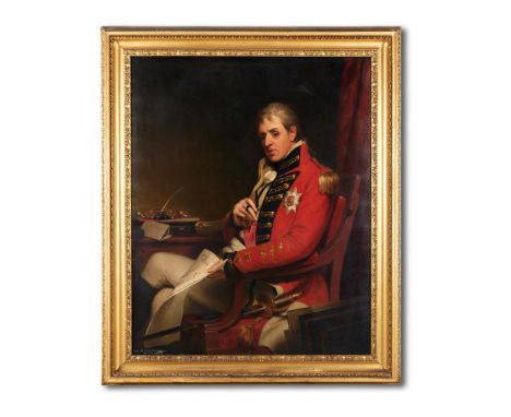
AFTER THOMAS PHILLIPSPORTRAIT OF GENERAL LORD HUTCHINSON OF ALEXANDRIA HOLDING A MAP OF EGYPTOil on canvasLater inscribed 'General Lord Hutchinson by Phillips' (lower left)127 x 102cm (50 x 40 in.) Literature:F. Sitwell, Weston Hall, Towchester, Northamptonshire: A Brief Guide, Northampton, 1993, p. 4, in the Dining Room.Catalogue Note:This oil on canvas portrait of John Hely-Hutchinson, 2nd earl of Donoughmore (1757-1832), is a close copy of a painting by Thomas Phillips (1770-1845) in the Royal Collection (RCIN 402776). The Royal canvas has near-identical dimensions to the portrait offered here - 50 x 40 ins. (127 x 102 cm.). The Royal portrait was painted in 1811 for George IV for 80 guineas in recognition of George's friendship with the sitter, who, as of 1803, had advised him on the governance of Ireland, and on the pacification of Queen Caroline. Lord Hutchinson was a well-known confident of George, when Prince of Wales, and became a regular visitor to Brighton Pavilion. The painting is recorded from the early-mid 19th century as having been at Carlton House, Windsor Castle and Hampton Court. Lord Hutchinson, army officer and politician, had an illustrious army career fighting against Napoleon's French revolutionary armies. In 1801, he commanded the first division of Sir Ralph Abercromby's army, which landed in Egypt on 10 March, and defeated the French at the battle of Alexandria. In December the same year, he was created Baron Hutchinson of Alexandria and of Knocklofty, co. Tipperary, with a pension of £2000 a year. He also received the new Turkish order of the Crescent in brilliants in March 1802. In 1825, he succeeded his brother as 2nd earl of Donoughmore and 2nd Viscount Hutchinson. He died, unmarried, at Knocklofty, co. Tipperary, in 1832, and was succeeded as earl and viscount by his nephew John Hely-Hutchinson (1787-1851). Colonel the Hon. Henry Hely-Hutchinson (1790-1874), the brother of the latter, and a professional solider who had served in the Peninsula and at Waterloo, married Harriet Wrightson (1788-1864) in 1825. Harriet Wrightson had inherited Weston Hall in 1809 through her aunt Mary Heber. Their fourth daughter, Louisa Lucy, married Sir Reresby Sitwell, Bt., in 1857, and hence the link with the Sitwell family.Condition Report: The canvas is not relined. There is some very fine craquelure throughout and some light surface dirt. There is some flaking and paint loss to the lower edge and a few further minor losses to the lower left quadrant. Inspection under UV reveals scattered retouching to the lower edge and a green masking varnish, which is uneven and may conceal further restoration. Otherwise, in generally good condition. Some minor scuffs and abrasions to the frame.Condition Report Disclaimer
Ɵ KEATE, George. and WILSON, Henry. An Account of the Pelew Islands, situated in the Western part of the Pacific Ocean. Composed from the Journals and Communications of Captain Henry Wilson. third edition, single volume, portrait, folding map, and 14 plates (of 15), contemporary tree calf, 4to., 1789.Condition Report: Lacks plan at p.233, folding plate at p.288 torn along crease.Condition Report Disclaimer

Ɵ STEPHENS, John L. Two Works: 1841-1843. comprises: Incidents of Travel in Yucatan. 2 vols., 1843; Incidents of Travel in Central America. 2 vols., 1841. together 4 volumes, both works with folding map, plates and illustrations, original cloth. Condition Report: spotting (mainly to tissue guards), volume 2 a bit wormed, including to spine.Condition Report Disclaimer
![Ɵ [WEBER, Freidrich Christian]. The Present State of Russia. 2 vols., first English edition, 2 engraved folding maps in vol.1](https://cdn.globalauctionplatform.com/86005164-2be8-4127-9a06-adb800bc24ae/5a4733a5-2ff2-4c9b-9ee1-adbb00f47c32/468x382.jpg)
Ɵ [WEBER, Freidrich Christian]. The Present State of Russia. 2 vols., first English edition, 2 engraved folding maps in vol.1, contemporary signature of Edward Jeffreys, contemporary panelled calf, 8vo., 1723-1722. Condition Report: Map of St. Petersburg with a few tears, binding somewhat worn.Condition Report Disclaimer
![Ɵ INDIA, SRI LANKA AND CHINA: 6 volumes. [RUSSELL, F.] A short History of the East India Company, 4to, 1793. - BERTOLACC](https://cdn.globalauctionplatform.com/86005164-2be8-4127-9a06-adb800bc24ae/5d6d09e0-c0ff-4afd-b4b7-adbb00f49455/468x382.jpg)
Ɵ INDIA, SRI LANKA AND CHINA: 6 volumes. [RUSSELL, F.] A short History of the East India Company, 4to, 1793. - BERTOLACCI. A. View of the Agricultural, Commercial and Financial Interests of Ceylon, presentation copy (inscription cropped), folding coloured map, 1817. - Considerations on the Danger and Impolicy of laying open the Trade with India and China, 2 editions (1st and 2nd) bound in one vol., 1812-13. - GRANT, R. The Expediency Maintained of Continuing the System by which the Trade and Government of India are now Regulated, 1813. - FORTUNE, R. A Residence among the Chinese, first edition, plates, illustrations, pp.389-396 with some repaired tears and a couple of leaves loose, 1857; and one other, various bindings, some worn.SOLD NOT SUBJECT TO RETURN.


Ɵ BESANCENOT, Jean. (Jean Girard, 1902 - 1992). Costumes et types du Maroc. number 127 of 310 copies, 60 coloured and plain plates by Besancenot, each numbered and identified on tissue guards, one double-page map, 8 plain plates printed recto/verso lettered A-H, loose as issued in original boards portfolio with printed label on upper cover, folio, Paris, Editions des Horizons de France, [1942].Jean Besancenot, pseudonym of Jean Girard, was a French photographer, painter, draughtsman and ethnologist. His art and ethnography represent Moroccan costumes and customs of the first half of the twentieth century. Provenance: The Art Library of Sir Sacheverell Sitwell, Weston Hall. Condition Report: text slightly spotted, portfolio worn (upper cover detached, lacking flaps, some fraying/tears, one tie detached) Condition Report Disclaimer

Ɵ WILLIAM FADEN THE COUNTY OF NORTHAMPTON Engraved and coloured folding map (now framed), second edition, London 1791 121cm x 131.5cm Condition Report: The backing board and frame have wormholes which have affected the map in a number of areas, generally yellowed all over and some damage Condition Report Disclaimer

FREDERICA HELY-HUTCHINSON 1840 A manuscript map of the Mediterranean, Africa and India, marked with the movements in the Roman Empire Pen and watercolour Signed and dated 1840 32-5cm x 53cm; a drawing of a Scottish dance, by another hand and three sketches of the monument for Frederick, Lord North, Earl of Guilford Catalogue Note: Frederica Hely-Hutchinson, second daughter of Colonel the Hon. Henry Hely-Hutchinson, was born before 1830 and thus this map is an example of her school work. (5) Condition Report: Some creases, damaged edges and marksCondition Report Disclaimer

Map Retro Globe Drinks Cabinet A Mobile Cabinet With Unique Graphics All Over In An Old Map Style, The Cabinet Opens To Reveal Three Compartments Which Can Hold Up To Four Wine Bottles And Up To Twelve Glasses, Keeping Everything Safely And Discreetly Stored Away, As Well As Giving You Something To Impress Your Guests When You Reveal The Contents Dimater Φ44.2 X 88H cm
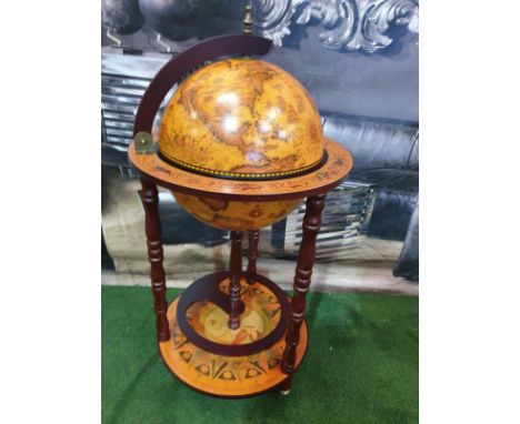
Globe Bar Cabinet Now here’s one for all the home-bar enthusiasts out there. Welcome this mini-globe bar from a piece to store and show off your drinks with pride. Using solid wood to form frame, the structure is tough and durable, keeping the upper cabinet securely in place. Covered in a faded old-map design sticker, the globe opens to reveal space to keep 2 two wine bottles and up to nine glasses Product Dimension: Ф44.2 x 88H (cm) Globe Diameter Inner: 33 cm Bottom Plate size: Φ41.5 x 1T (cm) Middle Shelf Size: Φ31.8 x 1T(cm)
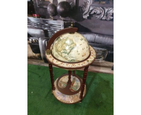
Retro Globe Drinks Cabinet Mobile Now here’s one for all the home-bar enthusiasts out there. A piece to store and show off your drinks with pride. Using solid wood to form the mahogany-coloured frame, the structure is tough and durable, keeping the upper cabinet securely in place. Covered in a faded old-map design, the globe opens to reveal space to keep up to three wine bottles and up to nine glasses Towards the bottom, a shelf is placed for extra holding room for up to five bottles, meaning you’ll always have enough to keep you quenched no matter what. Overall Dimension: Φ44.2 x 88H cm globe Dimension: Φ33 cm Bottom Plate Dimension: Φ41.5 cm Retro Globe Drinks Cabinet MobileNow here’s one for all the home-bar enthusiasts out there. A piece to store and show off your drinks with pride. Using solid wood to form the mahogany-coloured frame, the structure is tough and durable, keeping the upper cabinet securely in place. Covered in a faded old-map design, the globe opens to reveal space to keep up to three wine bottles and up to nine glasses Towards the bottom, a shelf is placed for extra holding room for up to five bottles, meaning you’ll always have enough to keep you quenched no matter what. Overall Dimension: Φ44.2 x 88H cm globe Dimension: Φ33 cm Bottom Plate Dimension: Φ41.5 cm
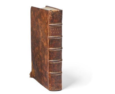
Ɵ SALE, George. The Koran. first edition of Sale's translation, single volume, folding engraved map, one folding plate (of Mecca) and 3 genealogical tables (all folding, 2 are pasted together), contemporary calf, 4to., 1734. The first edition of Sale's translation from Arabic into English of the Koran, to which he added an extended 'preliminary discourse', which comprised a compendium of all that was known about the religion of Islam at that time.(Qty. 1)Condition Report: Last leaf with loss to blank area, tear in margin of one plate, slightly stained in margin at beginning, binding slightly worn.Condition Report Disclaimer

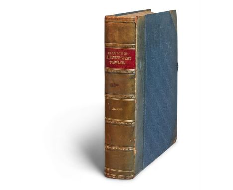
Ɵ ROSS, John. Narrative of a Second Voyage in Search of a North-West Passage, and of a Residence in the Arctic Regions during the Years 1829[-]1833. single volume, first edition, coloured folding map, 30 plates and charts, (9 coloured), later half calf, 4to., 1835.Ross and his men spent four winters in the Arctic. 'In searching for a passage south from Regent's inlet, the Victorywas stopped by ice, and spent the winter of 1829-30 in Felix harbour. In the summer of 1830 she got a few miles further south and wintered in Victoria harbour. But there she remained, held fast by the ice, and in May 1832 was abandoned. Ross and his men made their way to Fury Beach, where they passed a fourth winter in a hut built from the wreck of the Fury. They remained healthy by eating an Inuit diet. In the summer of 1833 they succeeded in reaching Ross's old ship, the Isabella in Lancaster Sound, and in her returned to England in October' (Oxford Dictionary of National Biography).(Qty. 1) Condition Report: short tear to map, plates spotted, binding slightly rubbed and slightly faded.Condition Report Disclaimer
Ɵ AFRICA: 3 vol., nineteenth-century. comprises: TULLY, R. Narrative of a Ten Years' Residence at Tripoli in Africa. 6 plates, (5 hand-coloured), facsimile title page (for second edition), contemporary calf, rubbed, rebacked, 4to., 1817; GALTON, F. The Narrative of an Explorer in Tropical South Africa. first edition, plates, folding map, green Spanish-style calf by Riviere, g.e., 8vo., 1853; ANDERSSON, C.J. Lake Ngami . . . second edition, plates, folding map, illustrations, original cloth, 8vo., 1856. (Qty. 3).SOLD NOT SUBJECT TO RETURN.Condition Report: 1. Narrative of a Ten Years' Residence at Tripoli in Africa - contemporary calf rubbed.3. Lake Ngami - original cloth faded, short tears at head of spine.Condition Report Disclaimer
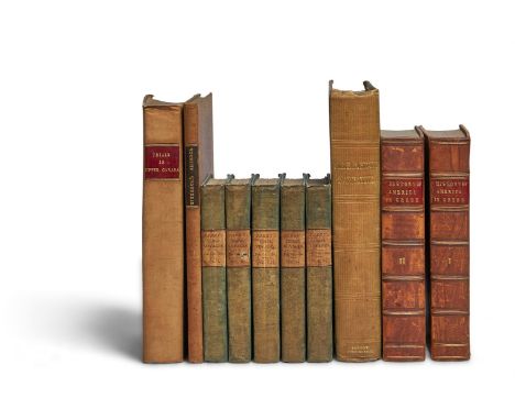
Ɵ CANADA and NORTH AMERICA: 10 volumes. Report of the Proceedings connected with the Disputes between the Earl of Selkirk and the North-West Company. first English edition, Montreal printed: London reprinted by B. M'Millan, 1819. - BIRBECK, Morris. Notes on a Journey in America, from the Coast of Virginia to the Territory of Illinois, lacks map, 1818, both volumes contemporary (? original) cloth, bit faded and soiled; and 8 others.SOLD NOT SUBJECT TO RETURN.Condition Report: Parry's Voyages - cloth worn and marked, spines bumped head/tail, internally reasonably clean; Trials in Upper Canada - boards creased with light marks, corners bumped and scuffed, spine bumped head/tail, internally clean; Head's Narrative - some light marks and fading to green cloth, gilt bright, corners scuffed, spine bumped head/tail, joint split to front pastedown, internally clean; Birbeck's Journey to America - boards marked and faded, corners scuffed, spine bumped head/tail, internally clean; History of America in Greek, some marks and scuffs to leather boards, bright gilt and labels, internally clean. Condition Report Disclaimer

Ɵ HUMBOLT, A. de. Personal Narrative of Travels to the Equinoctial Regions of the New Continent. vols. 1-2 (of 7, pub. 1814-1829). frontispiece map, 1814; Researches, Concerning the Institutions & Monuments of the Ancient Inhabitants of America. 2 vols., engraved titles and 19 plates (numbered 1 -20, 5 coloured), 1814, together 4 vols., first English editions, contemporary half calf, 8vo. (Qty. 4).Condition Report: Binding with very slight wear, small hole in spine of vol. 1 Narrative.Condition Report Disclaimer

Ɵ WAUGH, Evelyn. (1903 - 1966). Black Mischief. Author's Presentation copy to Georgia Sitwell, London: Chapman Hall Ltd., 1932. Limited large paper edition, illustrated, signed and numbered by the author to limitation page, No. 58 of 250 copies, single volume, 8vo., (203 x 160mm), original purple, bevelled publisher's buckram, gilt vignette to front, gilt decorated titled spine, gilt top, edges untrimmed, further inscribed by the author to front free e/p. in black ink, 'For Georgia / with love from / Evelyn', half-title, 8 full-page illustrations, including frontispiece, none of which appear in the trade edition, plus a full-page map of the Azanian Empire, purple silk ribbon bookmark detached and loosely inserted, 323pp. Evelyn Waugh was a close friend of all three literary Sitwells, Edith, Osbert and Sacheverell. This book is inscribed to Sacheverell's wife, Georgia Sitwell (1905-1980). Evelyn Waugh often stayed at the primary family estate, Renishaw Hall, Derbyshire, beginning in 1930 when he stopped by with Robert Byron for an extended stay. His last visit was in 1957, after which Osbert became increasingly debilitated by Parkinson's disease. Waugh was Edith's 'sponsor' in her conversion to Roman Catholicism. Provenance: The Sitwell Family Library, Weston Hall.Condition Report: boards and spine faded, gilt vignette and lettering to spine bright, untrimmed edges a little foxed, foxing somewhat heavier to endpapers, a few marks along the internal joints o/w. clean and bright internally.Condition Report Disclaimer


John Pinches - an Elizabeth II silver and parcel gilt map of the world, 'The Royal Geographical Society Silver Map', 14½ x 22in. (36.8 x 55.8cm.), with certificate, in original frame. * The map in good condition with no faults. Some damage to surface of the wood on the lower corners of frame.

Channel Islands German Occupation interest - a German Military map of St. Ouen's Bay Jersey, the map titled '"JAKOB" UBERWACHUNGSWEG', dated and signed lower right 5-1-42, showing the headland of St. Ouen's Bay, highlighting the Towers and surrounding areas - Lighthouse; Corbiere; La Moye; Les Brayes; La Rocco Tower; Martello Tower; Kempt Tower etc., 18½ x 31in. (47 x 78.8cm.). * Provenance: From the Richard Mayne bunker museum collection, Jersey.

A rare German Kriegsmarine map of Sark and Herm, the map titled "Deutsche Heereskarte - Nicht für die Öffentlichkeit bestimmt!", Nr.16 Süd West Les Pieux, the bottom of the map dated 1943, 1:50000 etc., the whole with numbered red sectional grid, 23½ x 31in. (58.4 x 78.8cm.). * Folds and wear, rip/hole to bottom left.


A German Luftwaffe map of the UK with Channel Islands and French coast, the coloured map with eagle insignias and titled "LUFT - NAVIGATIONSKARTE IN MERKATORPROJEKTION" MaBstab auf Breite 1:2000000, red numbered sectional grid, the bottom of map with Berlin 1939 etc., 43 x 46in. (109.2 x 116.8cm.). * Tears to folds, staining etc., fair.


Greenwood, Christopher and John, Map of the County of Devon, from an actual survey made in the years 1825 & 1826.....Corrected to the Present Period', pub. Greenwood & Co., London, July 4th 1829, engraving with hand colouring, inset of Lundy Island, vignette of Exeter Cathedral, compass rose, 24½ x 28in. (62.25 x 71cm.), in a Hogarth frame, some toning and fading.


FALLE, (The Rev) Philip, Caesarea: Or an Account of the Island of Jersey, the greatest of Islands remaining to the Crown of England of ancient Duchy of Normandy, with an appendix of records, &c. an accurate Map of the Island, and a Prospect of Elizabeth Castle, folding map hand-coloured in outline, folding plate, Elizabeth Castle, London, printed for T. Wotton, 1734, new full calf with gilt title to backstr, 2nd edition. scarce


Monin, C. V., Monde Connu des Anciens, engraved map of Europe, North Africa and the Near East, with hand coloured outlines, pub. Paris 1839; together with two other 19th century engraved maps of Agde with the Fort de Brescou in the south of France and Great St Bernard and Mount Blanc, Switzerland all framed and glazed (3)

-
109198 item(s)/page