We found 109182 price guide item(s) matching your search
There are 109182 lots that match your search criteria. Subscribe now to get instant access to the full price guide service.
Click here to subscribe- List
- Grid
-
109182 item(s)/page


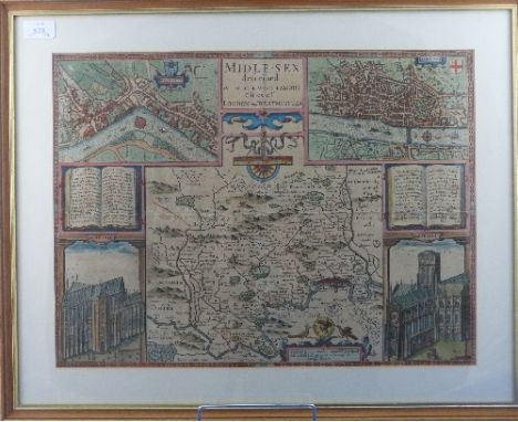
Lot 578
Middlesex Speed (John), Midle-Sex described with the most Famous Cities of London and Westminster, pub. Thomas Bassett & Richard Chiswell, c.1676, engraved map with sparse outline colouring, inset town plans of Westminster and London, inset vignettes of St. Peters and St. Pauls, 15in x 20in (38cm x 50.75cm), framed, together with John Speed's England - A coloured facsimile of the first edition - Part Two - pub. 1953 (2)


Lot 173
A great collection of original props & set dressing items from ITV's ' Broadchurch ' which starred David Tennant & Olivia Coleman. The props comprising of; a Broadchurch Town Map, Broadchurch Church pamphlet, 2x ' Exploring Church Of St Bede ' leaflets, 3x unused ' Broadchurch District Council ' vehicle stickers, and a postcard of the Church. All from Series 1. Interesting collection.


Lot 25
Voyages.- Froger (François) A Relation of a Voyage made in the Years 1695, 1696, 1697 on the Coasts of Africa, Streights of Magellan, Brasil, Cayenna, and the Antilles, by a Squadron of French Men of War, under the Command of M. de Gennes, first edition in English, engraved additional pictorial title and 15 plates and maps, 2 folding, some spotting and soiling particularly to final gathering, contemporary sprinkled calf, rubbed, spine slightly torn at head, [Sabin 26004; Wing F2233], 8vo, M. Gillyflower [& others], 1698.⁂ Describing an unsuccessful attempt to found a French colony in the Straits of Magellan, and including the earliest definitive map of Rio de Janeiro.

Lot 26
Voyages.- Ramusio (Giovanni Battista) Delle Navigationi et Viaggi, 3 vol., collation: vol.1. a4, b-d8, e10, a-v8, x10, y-z, aa-zz, aaa-bbb8, ccc10 ; vol.2. 1-26, 34, 46, 54, A-Z, AA-II8, A-X4, Y6 ; vol.3. *6, B-D8, E-F6, A-Z, Aa-Vv8, Xx4, Yy-Zz, Aaa-Eee8, Fff10, mixed edition (as usual), titles with woodcut printer's device (also on final leaf of vol.2 & 3), vol.1 with final blank, 3 double-page engraved maps of Africa, India and Indochina (bound so that superimposed when open) in vol.1, 7 folding and 2 full-page woodcut maps in vol.3, woodcut initials and text-illustrations of indigenous people, fauna, flora etc. of , some full-page, some foxing and browning, mostly light but more severe to a few leaves, one or two minor marginal defects (paper flaw hole to c6 in vol.1, slight worming to lower outer corner at beginning of vol.2, Mm3 in vol.3 lacking small portion to outer margin), later vellum with traces of ties, rubbed and slightly stained, rebacked and recornered in vellum, calf labels, a good copy, [vol.3 Adams R139], folio, Venice, Giunti, 1613-1583-1606.⁂ One of the most important collections of early voyages and travels.The first volume is mainly concerned with Africa and southern Asia, the second with Central Asia, Russia, and the Northern Seas, while the third volume is entirely devoted to America, and includes accounts of Peter Martyr, Oviedo, Cortes, Cabeza de Vaca, Guzman, Ulloa, Coronado, Fray Marcos di Niza, Xerez, Verrazano and Cartier. The double-page maps are of Cuzco in Peru, La Nuova Francia (Newfoundland, second separate map of Northeast America), Brazil, Sumatra (first map of any island in S.E.Asia), Parte de Lafrica, La Terra Hochelaga nella Nova Francia (Montreal, earliest printed plan of a settlement in North America) and Universale della Nuovamente Parte del Mondo Ritrovata (world map of the Western Hemisphere, one of the most complete of its time). There are also full-page maps of Isola Spagnuola (Hispaniola) and the city of Temistitan in Mexico.
![America.- Bry (Johann Theodor de) and Jacques Le Moyne. Brevis Narratio eorum quae in Florida Americae Provi[n]cia Gallis acc](https://cdn.globalauctionplatform.com/7c8bff0e-7cd8-4a74-840e-a8cc010d5314/3ea87c6f-9aef-4f97-88ce-381dec5b5614/468x382.jpg)
Lot 291
America.- Bry (Johann Theodor de) and Jacques Le Moyne. Brevis Narratio eorum quae in Florida Americae Provi[n]cia Gallis acciderunt, part 2 only, engraved title, portrait vignette and 22 plates with letter press text only (of 42), lacking folding map, woodcut initials, head- and tail-pieces, engraved title neatly repaired, occasional browning, modern calf-backed boards, [Sabin 8784], folio, Frankfurt, Joannis Wechel, 1591; and another, on the same; sold not subject to return (2)

Lot 295
Atlases.- Le Rouge (Georges-Louis) Introduction a la Geographie, with engraved double-page additional allegorical title 'Atlas Nouveau Portatif à l'Uage des Militaires et du Voyageur', 3 hand-coloured engraved plates of spheres, 86 maps hand-coloured in outline and engraved plan of Paris and plate of flags, all double-page, a few also folding, several maps incorporating cartouches and/or vignettes, water-staining to lower corner of engraved title and text and a few maps, light foxing and browning to maps, map 31 with tear to fold, map 32 slightly defective at outer margin up to plate-mark, contemporary mottled calf, spine gilt with, old paper label at end, a little rubbed and stained, two wormholes to foot of spine, corners worn, 4to, Paris, chez l'Auteur, Prault le fils, la Veuve Robinot, 1756.⁂ Mostly covering Europe and areas of France but including Turkey, the Holy Land, Persia, China, Japan, Egypt, and islands of the East and West Indies.

Lot 299
Atlases.- Ratelband (Johannes) Geographisch-Toneel, Of uitgezochte Kaarten, Tot gemak der Officieren, Reisigers en Liefhebbers, hand-coloured wood-engraved title decoration, folding hand-coloured plate and 40 folding hand-coloured maps and views, contemporary red morocco, gilt, g.e., tall thin 8vo (200 x 83mm.), Amsterdam, J. Ratelband, 1735.⁂ Very rare Dutch pocket atlas, with all 41 maps and plates coloured by a contemporary Dutch hand. Published for 18th-century European travellers and for military officers.Johannes Ratelband (II) (1704-1730) was one of the key members of a long dynasty of Dutch printers/ book and map sellers in Amsterdam. The firm began with Jansz. Ratelband (1590-1656), who moved from Germany to set up a press and shop in Amsterdam at the beginning of the 17th century. The firm flourished uninterrupted until the 1820s, perpetuated by a succession of family members. OCLC list two copies of the atlas worldwide; one in the Bibliothèque Nationale, Paris (1732 edition) and one in the British Library (1747 edition with 37 maps). Not in Koeman or Shirley: though Koeman cites an edition of 1732 with 37 maps (K. III, Rat. 1) and Shirley an edition of 1747 also with 37 maps (Shirley, G.Rat1a).
![India.- Anonymous (late 19th century) Sketch of the Fort and Citadel of Beejapoor [Bijapur], manuscript plan with references](https://cdn.globalauctionplatform.com/7c8bff0e-7cd8-4a74-840e-a8cc010d5314/d92c5503-c9de-47c3-e2a7-2a67df831900/468x382.jpg)
Lot 309
India.- Anonymous (late 19th century) Sketch of the Fort and Citadel of Beejapoor [Bijapur], manuscript plan with references below, and two sheets with 4 pp. of 'Descriptions of Buildings in Bejapoor and other objects of intrerest', pen and black ink, the map on wove paper, 365 x 325 mm. (14 3/8 x 12 3/4 in), the manuscript descriptions on laid paper with watermark date '1878', several folds and handling creases, minor spotting and surface dirt, loose, unframed, [circa 1870-80s].⁂ The citadel and fort at Bijapur was completed by the Adilshahi Sultans in 1566. The novelist and Indian clerk Philip Meadows Taylor (1808-1876) described the site in 1866 as having "palaces, arches, tombs, cisterns, gateways, minarets, ...all carved from the rich basalt rock of the locality, garlanded by creepers, broken and disjointed by peepul trees, each in its turn is a gem of art and the whole a treasury."
![Japan.- Shōhachi (Ezuya, publisher) Folding map of Japan [Dainihon-Hayabiki-Saiken-Ezu], showing from Kyushu & Okinawa to Toh](https://cdn.globalauctionplatform.com/7c8bff0e-7cd8-4a74-840e-a8cc010d5314/34266538-b8bf-40e0-be96-7f4843314d34/468x382.jpg)
Lot 317
Japan.- Shōhachi (Ezuya, publisher) Folding map of Japan [Dainihon-Hayabiki-Saiken-Ezu], showing from Kyushu & Okinawa to Tohoku, woodcut with some hand-colouring, 370 x 1470 mm. (14 1/2 x 57 7/8 in), on five sheets joined, some splitting to folds, surface dirt and browning, loss to lower right, other minor nicks, folding with blue card endpapers with printed text, very worn, 8vo, [1842]

Lot 321
South East Asia.- De Bourges (Jacques) Relation du Voyage de Monseigneur l'Eveque de Beryte, Vicaire Apostolique du Royaume de la Cochinchine, par la Turquie, la Perse, les Indes..., first edition, folding engraved map, some marginal worming throughout, just slightly affecting border of map but no text, contemporary calf, spine gilt, a little rubbed and repaired, [Cordier, Bibliotheca Sinica 827; Chadenat 532], 8vo, Paris, Denys Bechet, 1666.⁂ A very good copy of this important early work on Thailand. "Jacques de Bourges produced the first published account of Siam by a Frenchman and preceded by twenty years the great mass of texts that appeared from the return of the first French embassy to Siam." (Michael Smithies, Jacques de Bourges (c.1630-1714) and Siam).

Lot 335
Britain.- Cary (John) Cary's Actual Survey of the Fifteen Miles Round London, engraved double-page general map and 50 engraved single-page maps, hand-coloured in outline, general map linen-backed with repairs and some restoration, 19th century half calf, 1786; Cary's Traveller's Companion, engraved title, advertisement, contents, and 43 maps, one large and folding, all hand-coloured in outline, some light offsetting, contemporary half calf, 1819; and 2 others, including Cary's Reduction of his Large Map of England and Wales, 8vo (4)

Lot 336
Britain.- Cary (John) Cary's New and Correct English Atlas, engraved title, dedication and 47 maps hand-coloured in outline, occasional foxing or offsetting, bookplate, contemporary morocco-backed boards, rubbed, for John Cary, 1787; Cary's New Map of England and Wales with part of Scotland..., engraved title, dedication, hand-coloured general map of Britain and 79 maps (lacking 62 and 80 as issued), modern half morocco, by J.Cary, 1794, 4to (2)

Lot 341
Britain.- Lewis (Samuel, publisher) An Atlas Comprising Maps of the Several Counties..., engraved folding map of England and Wales, plan of London and 55 county maps, many folding, loss to head of spine, 1842; Lewis's Atlas comprising the Counties of Ireland, engraved general map and 32 county maps, 1837; A Topographical Dictionary of Scotland, Atlas vol. only, 6 large engraved hand-coloured maps, 1846, original cloth, spines faded, spine ends and corners a little bumped; and another Lewis English atlas, 4to (4)

Lot 346
Ireland.- Taylor (George) and Andrew Skinner. Taylor and Skinners's Maps of the Roads of Ireland, Surveyed 1777, first edition, large folding engraved map of Ireland (with short tear to inner margin) and 288pp. of maps, engraved title dedication and page of explanation, list of subscribers at end (slightly water-stained), light offsetting, bookplate, contemporary calf, gilt, a little rubbed, 8vo, G. Nicol, London and W. Wilson, Dublin, 1778.

Lot 35
Aeronautics.- Lunardi (Vincenzo) An Account of the First Aërial Voyage in England, first edition, with author's signature of authentication on half-title (as usual), engraved portrait by Bartolozzi after Cosway and 2 folding plates, explanation of plates/advertisement leaf at end (small stain to latter), variant with "of my ascension" as final line of p.48, [Hodgson p.401], for the Author, 1784 bound with [Knox (John) A View of the British Empire, more especially Scotland; with some proposals for the improvement of that country, the extension of its Fisheries, and the relief of the people, first edition, small stain to title, for J.Walter [& others], 1784 and Emperor's Claims (The). Being a Description of the City of Antwerp and the River Schelde, folding hand-coloured engraved map, 7pp. advertisements at end, for John Stockdale, 1785, together (with another) 4 works in 1 vol., some light soiling, contemporary tree calf, spine gilt with red roan label, rubbed, spine worn at head, joints split, 8vo⁂ Lunardi was an Italian diplomat who made the first British ascent in a hydrogen balloon, on 15 September 1784.
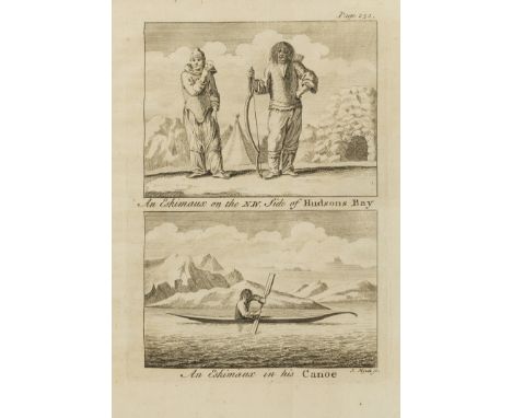
Lot 4
Americas.- Ellis (Henry) A Voyage to Hudson's-Bay, by the Dobbs Galley and California...for Discovering a North West Passage, first edition, folding engraved map, 9 engraved plates, 5 folding, list of subscribers to the expedition, occasional light soiling, contemporary ink inscription of Thomas Fane to front free endpaper, contemporary calf, rubbed, [Sabin 22312], 8vo, for H.Whitridge, 1748.⁂ Ellis was the surveyor on this voyage which proved, once and for all, that a North-West passage from Hudson's Bay did not exist. The work contains some of the earliest information on the customs of the Inuit.

Lot 52
Ireland.- Taylor (George) and Andrew Skinner. Taylor and Skinners's Maps of the Roads of Ireland, Surveyed 1777, first edition, large folding engraved map of Ireland, engraved vignette title, dedication/page of explanation and 288 maps on 144 leaves (printed on both sides), letterpress list of subscribers at end, contemporary ink inscription "1779 Jan.ry 22d Will Fairbrother " at head of title (date slightly shaved) and with his engraved bookplate, folding map a little creased at edges with a couple of short tears, light staining to a few maps, contemporary sprinkled calf, spine gilt with red morocco label, slightly rubbed, 8vo, G. Nicol, London and W. Wilson, Dublin, 1778.
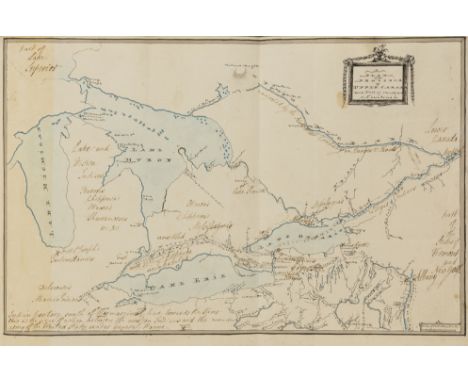
Lot 6
Americas.- Simcoe (John Graves).- First Nations.- Baker (Lt.-Col. Sir Edward, née Baker Littlehales, 1st Baronet ) Plan of the Province of Upper Canada with part of the Adjacent Countries, manuscript map, covering Lake Michigan, Lake Huron, Lake Erie, and Lake Ontario, title in cartouche upper right, with numerous contemporary annotations including 'Governor Simcoe's Route' for his exploratory tour of 1793, annotations listing Indian tribes, and with an asterisk location showing General "Mad" Anthony Wayne's 'The Battle of Fallen Timbers', amongst other details, pen and black ink, blue watercolour wash, annotations in brown ink, on laid paper without watermark, 255 x 375 mm. (10 x 14 ¾ in), central folds, light spotting and browning, [circa 1793] bound with Hearne (Samuel) A Journey from Prince of Wales's Fort in Hudson's Bay, to the Northern Ocean, undertaken by order of the Hudson's Bay Company, for the Discovery of Copper Mines, a North West Passage, &c. in the Years 1769, 1770, 1771, & 1772, first edition, folding engraved map with routes supplied by hand in red, green and yellow, 8 engraved plates and plans, 6 folding, 2 double-page, with final advertisement/directions to binder leaf, wide margins, text with wormhole to lower margin, occasional light browning, one or two small stains, 2 small paper flaw holes to margin of 3I2, with loosely inserted hand-coloured engraved map of 'British Dominions of North America' (Henry Fisher, 1823), engraved bookplate of Sir Edward B.Baker, Bt., with the manuscript map of Simcoe expedition mounted on stub at end, handsome contemporary mottled calf, spine gilt with red roan label, a little rubbed, small worn patches and scratches to lower cover, [Sabin 31181], 4to, for A.Strahan and T.Cadell, 1795.Provenance:Lt. Col. Sir Edward Baker (née Baker Littlehales), Ranston Library, Dorset⁂ Unique record of the exploratory tour undertaken by Simcoe and Baker from Niagara Falls to Detroit in 1793, and of the First Nations people of Canada and north America. Lt. Col. John Graves Simcoe (1752-1806) was commander of the Queen's Rangers in America during the Revolutionary War. Later, between the years 1791 and 1796, he served as the first lieutenant governor of Upper Canada. Lt. Col. Sir Edward Baker (née Baker Littlehales, 1st Baronet, d.1825), of Ranston, Dorset, was the aide-de-camp to Lt. Col. Simcoe, and author of Journal...of an Exploratory Tour partly in sleighs but chiefly on foot, from Navy Hall, Niagara, to Detroit made in the months of February and March, A.D. 1793, by His Excellency Lieut. Governor Simcoe, published posthumously in Toronto in 1889. The work did not include a map.The manuscript map tipped into the present volume was produced by Baker in the 1790s, and contains details of the route taken by him and Lt. Col. Simcoe on his 'Exploratory Tour' in 1793. The map features numerous annotations, including details of the Ottowa River from Montreal "navigated by the North West Company in Canoes & Boats", and details of Native Indian settlements including 'Mohawks', 'St Regis Indians', 'Ottawa's Chippewa's', and 'Delaware's Miami's Indians' amongst others. It also locates the "Indian territory south of this marginal line towards the River Ohio [as] the scene of action between the western Indians and the army of the United States under General Wayne", the final battle of the Northwest Indian War, August 20, 1794.
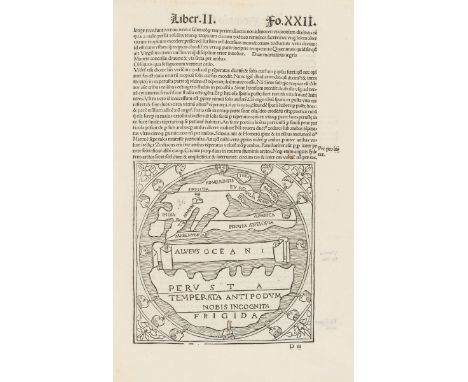
Lot 76
Macrobius (Ambrosius Aurelius Theodosius) Macrobius Aurelius integer nitidus suoque decori ab Ioanne Rivio superioribus annis & nunc cura Ascensianorum multo diligentius restitutus, edited by Joannes Rivius, collation: A-M8 N10, title and woodcut printer's device within woodcut architectural border, woodcuts within text, including a world map on f.XXII, and a map of the five climatic zones on f. XX, woodcut criblè initials, final f. blank, occasional early ink marginalia, signature to head of title, [Paris], Badius Ascensius, [November, 1519] bound with Apuleius. Apuleius cum commento Beroaldi: & figuris nouiter additis, commentary by Philippus Beroaldus, woodcuts within text, woodcut decorative initials, [Venice], [Joannis Tacuinis de Tridino], [June, 1516], together 2 works in 1 vol., occasional spotting or staining, contemporary blind-stamped calf, upper cover detached, spine ends and corners worn, rubbed and scuffed, folio (317 x 215mm.). ⁂ Macrobius' commentary on Cicero's Somnium and Saturnaliorum, with a woodcut world map. Includes many incidental remarks on geography, astronomy, physics and mathematics.Provenance: 'Charles Chabroud, Avocat' (engraved bookplate). Literature: I: Adams M74; Sabin 43657. II: Adams A1375; EDIT 16 CNCE 2226.

Lot 92
Jerusalem.- Prado (Jeronimo de) and Juan Bautista Villalpando. In Ezechielem Explanationes et Apparatus Urbis, ac Templi Hierosolymitani Commentariis et Imaginibus illustratus, 3 vol., first edition, 3 engraved titles, portrait and 31 plates/vignettes only (of 32, lacking folding plate between pp.13 and 17, vol.1), most folding or double-page, 8 folding tables (one printed in red and black), woodcut map and other small woodcut illustrations and diagrams in text, a few plates with repairs, some foxing and light staining but generally a sound copy, later vellum, red and green morocco spine labels lettered in gilt, extremities a little worn, folio, Rome, 1596-1605.⁂ A very good copy of this monumental work on the Temple of Solomon in Jerusalem.Provenance: St Hugh's Parkminster (small ink stamp to titles)

Lot 1
Africa.- Lyon (Capt. George Francis) A Narrative of Travels in Northern Africa... accompanied by geographical notices of Soudan, and of the course of the Niger, first edition, signed and inscribed by the author to his aunt "The Lady Sophia Fitzgerald from her very affectionate nephew Geo. F.Lyon" in ink at head of title, 17 hand-coloured lithographed plates after Lyon, folding engraved map with routes supplied by hand in red and blue, illustrations, preliminaries misbound, some light spotting and soiling, title reinforced at fore-edge, 3A4 defective at upper outer corner not affecting text, contemporary half roan, a little worn, [Abbey, Travel 304; Blackmer 1044], 4to, 1821.⁂ Accompanied by Joseph Ritchie, Lyon left Tripoli to discover the source of the Niger river. They travelled disguised as Muslims but at Murzuq, the capital of Fezzan, Ritchie fell ill and died.
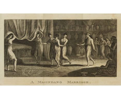
Lot 10
Asia.- Forrest (Capt. Thomas) A Voyage to New Guinea, and the Moluccas, from Balambangan: including an account of Magindano, Sooloo, and other Islands, first Dublin edition, folding engraved map and 3 engraved plates, one folding, occasional light soiling or browning, contemporary calf, rubbed, spine worn at head, 8vo, Dublin, Price, W. & H.Whitestone, Sleater [& others], 1779.⁂ Including Magindano and Papua vocabularies at end.
![France.- [Sauvan (Jean Baptiste Balthazar)] Viage Pintoresco por las Orillas del Sena, desde Paris hasta el Mar, translated b](https://cdn.globalauctionplatform.com/7c8bff0e-7cd8-4a74-840e-a8cc010d5314/2bf2b580-be4f-487d-d081-223b7d7feb57/468x382.jpg)
Lot 12
France.- [Sauvan (Jean Baptiste Balthazar)] Viage Pintoresco por las Orillas del Sena, desde Paris hasta el Mar, translated by J. J. de Mora, first edition in Spanish, hand-coloured engraved map, hand-coloured aquatint title-vignette & tail-piece and 24 superb hand-coloured aquatint plates after A. Pugin and J.Gendall, light foxing to text but plates very clean and bright, contemporary half calf, gilt-stamped red morocco label on upper cover, spine gilt, a little rubbed, [cf. Abbey, Travel 90 & Tooley 445, English edition of 1821], folio, R.Ackermann, 1826.⁂ Scarce Spanish edition of one of Ackermann's finest publications, with magnificent views along the river Seine.
![Oceania.- [Fleurieu (Charles Pierre Claret, Comte de)] Discoveries of the French in 1768 and 1769, to the South-East of New G](https://cdn.globalauctionplatform.com/7c8bff0e-7cd8-4a74-840e-a8cc010d5314/942a0fd6-f32f-433c-ee45-a5c0813069b6/468x382.jpg)
Lot 18
Oceania.- [Fleurieu (Charles Pierre Claret, Comte de)] Discoveries of the French in 1768 and 1769, to the South-East of New Guinea, first edition in English, half-title, 12 folding engraved maps and plates, most a little foxed and stained (as usual), some offsetting, first map torn at fold (rather crudely repaired), light damp-staining to margins of last few leaves of text, bookplate of John Ashley Warre, later half calf, red morocco label, a little rubbed, [Ferguson 105; Sabin 24749], 4to, for John Stockdale, 1791.⁂ Account of exploration by the French, British and Spanish, important for the rediscovery of the Solomon Islands.
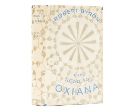
Lot 195
Byron (Robert) The Road to Oxiana, first edition, frontispiece, map and 15 plates, original cloth, spine very slightly faded, dust-jacket, spine ends and corners a little chipped with sympathetic minor restoration and strengthening, rubbing to extremities, in effect an excellent copy, 8vo, 1937.⁂ An attractive example of Byron's classic travelogue, difficult to find in good condition.
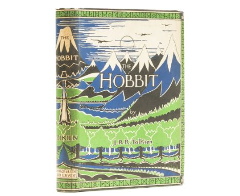
Lot 206
Tolkien (J.R.R.) The Hobbit, or There and Back Again, first edition, first impression, frontispiece, one plate and 8 illustrations, including 7 full-page, map endpapers printed in red and black, all by the author, 2pp. advertisements, occasional scattered spotting, original pictorial cloth, slight shelf-lean, very minor bumping to corners, else fine, first state dust-jacket with the misprint "Dodgeson" for "Dodgson" corrected by hand on rear flap, light spotting and horizontal mark to spine, light toning to extreme head and foot of flaps, light scuffing and creasing to corners, some very minor surface soiling, but a sharp, near-fine example overall, 8vo, 1937.⁂ A superb copy of Tolkien's landmark work.

Lot 209
Tolkien (J.R.R.).- Printed programme for the New College School production of The Hobbit, adapted by Humphrey Carpenter with music by Paul Drayton, 4pp., illustrations, with map by Drayton to final p., signed by Tolkien on upper cover, minor creasing, some light toning to margins of upper cover, [Hammond pp.23-24], 4to, 1967.⁂ A rare signed playbill for the second theatrical adaptation of The Hobbit.The first production of The Hobbit was performed at St. Margaret's School, Edinburgh for teachers and parents in 1953. This second production was a larger affair, performed over three nights, with the author in attendance on the final night. The play was adapted by Humphrey Carpenter and music composed by the school music teacher Paul Drayton (who also drew the map for the lower cover). Signed copies of the book were raffled off each night, Tolkien also signed copies of the programme for the performers.
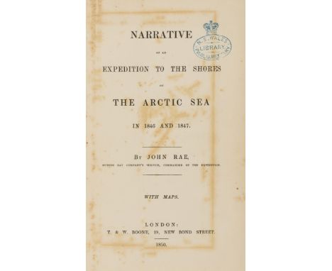
Lot 21
Polar.- Rae (John) Narrative of an Expedition to the Shores of the Arctic Sea in 1846 and 1847, first edition, 2 folding engraved maps hand-coloured in outline, without the 10pp. advertisements at end, maps foxed and offset onto facing leaves (including title), large map with short tear at edge (repaired), some other foxing, mostly at beginning and end, ex-library copy with ink stamp to title, verso of maps and one or two other leaves, contemporary half calf, later black roan label, a little rubbed, [Sabin 67428], 8vo, 1850.⁂ Rae was sent by the Hudson's Bay Company to survey the north coast of Canada. The work provides much information on the natives of the area and also lists the fauna and flora. On a later journey he discovered the fate of Sir John Franklin and his expedition.
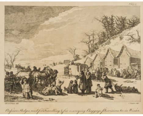
Lot 22
Russia.- Chappe d'Auteroche (Jean, Abbé) A Journey into Siberia, made by order of the King of France, first English edition, folding hand-coloured engraved map, 9 engraved plates (mostly of costumes), rather soiled and browned (mainly text), light water-staining to foot of plate of thermometers, tear to Kk3 not affecting text, bookplate of Richmond Allen, contemporary tree calf, red roan label, rubbed, spine worn at head, 4to, for T.Jefferys, Geographer to the King, 1770.⁂ Chappe d'Auteroche was sent to Siberia to study the transit of Venus which was due in June 1761. On his return he published this account of the manners and customs of the native inhabitants.


Lot 479
Selection of WW2 British Military Equipment, consisting of a pair of 1938 dated British officers Binoculars stamped with makers details and “BINO PRISM No2 MK II X6 No 10899”, housed in 37 pattern webbing box with clear ink stamp date 1939 inside; 1937 pattern webbing belt and holster set with ammunition pouches; 1940 dated 37 pattern webbing ammunition pouch; 1944 dated 37 pattern webbing officers map case; Gas mask in canvas carry case and Bren Gun magazine (empty). All generally in good condition.
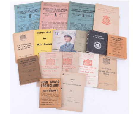
Lot 481
Selection of WW2 Period Manuals etc, including Small Arms Manual, Home Guard Proficiency, 1943 Hints on Map Reading Instruction, First Aid in Air Raids, 1941 Regulations for the Auxiliary Territorial Service, Journal of the Air Raid Protection Institute, Small Arms Training Anti-Tank Rifle 1942, plus others. Various conditions. (18 items)


Lot 189
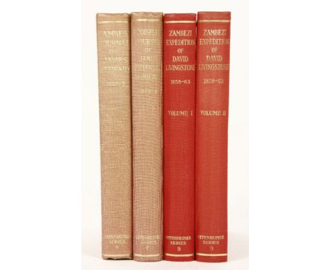
Wallis, J.P.R. (ed).: 1- The Zambesi expedition of David Livingstone 1858-1863; in 2 volumes (Signed copies). Chatto & Windus, 1956. Complete with 2 folding maps and colour plates. (Oppenheimer Series, 9). Both volumes Signed by Wallis on title pages. Original red cloth gilt, t.e.g.; 2- The Zambesi Journal of James Stewart 1862-1863. Chatto & Windus, 1956. Complete with folding map and frontis portrait. (Oppenheimer Series, 6). Original red cloth gilt, t.e.g.; 3- The Barotseland Journal of James Stevenson-Hamilton 1898-1899 (Signed copy). Chatto & Windus, 1953. Complete with a frontis, 5 colour plates and a folding. (Oppenheimer Series, 7). Both volumes Signed by Wallis on title pages, also the front blank endpaper inscribed: To Bob, with all best wishes from Dora and Jack (Dora was his wife). Original red cloth gilt, t.e.g. (4)
-
109182 item(s)/page