We found 109182 price guide item(s) matching your search
There are 109182 lots that match your search criteria. Subscribe now to get instant access to the full price guide service.
Click here to subscribe- List
- Grid
-
109182 item(s)/page


Lot 143
A Cold War double sided fabric map for Kabul and Samarqand, edition I GSGS, Printed for D. Survey (War Office and Air Ministry) by Balding & Mansell Ltd, 1958, 68 x 71cm, together with various other post WW II fabric and paper maps to include Stalingrad / Stepnoy, Somaliland and Bucharest / Lublin - Zhitomir etc. (approx. 34 some duplicates.)
Lot 200
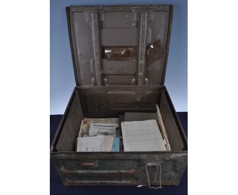
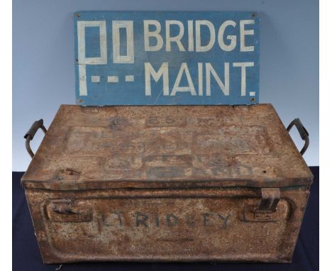
Major Eric Spencer Ridley, Royal Tank Regiment, a collection of ephemera some relating to Operation Husky and the invasion of Sicily to include 231 Infantry Brigade ADM Order No.1, marked MOST SECRET. OFFICER ONLY Copy No. 59 22 June 43, one other Copy No. 60, Extract of Map Reference Code No.1 hand written 1st Scorpion Regt x2, Moon Chart for July Lattitude 35.0 N. and Personal Message From The Army Commander, all in a OHMS envelope hand written to the front "Not to be opened till receipt of movement orders", Message Forms relating to Eighth Army / Scorpion Regiment, H.Q. 1 Armoured Regt. R.E. Move Forward document dated 16th March 1945, Sherman Tank Guidance documents and Exercise Alpha SECRET Copy No. 6, "A" Assault Sqn RAC/RE etc., all contained in a travel trunk marked to the lid Captain E.S. Ridley, 14 Albert Crescent, Bury St Edmunds, Suffolk, England.
Lot 201
Major Eric Spencer Ridley, a collection of ephemera and training manuals to include Top Secret HQ RE 46 Division document, dated 2 Dec 44 Copy No.8, Royal Engineers Reconnaissance Pocket Book, Army Book 155, Popular Guide to the German Army No.3 Air-Bourne Troops, Tank Gunnery With The 75mm Gun Vol. 1 Part 1 1942, a field map case and painted wooden sign etc., contained in a tin trunk named to the lid Capt. E.S. Ridley, 14 Albert Crescent, Bury St Edmunds, Suffolk, England.


Lot 17
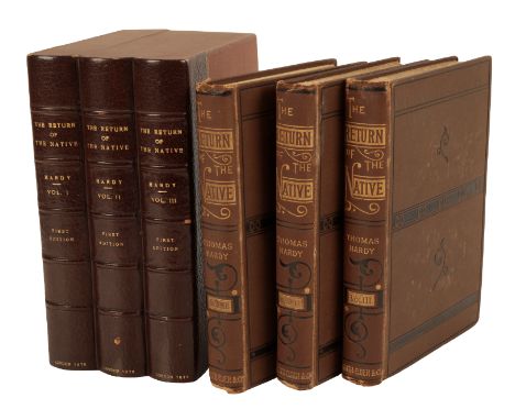
HARDY, THOMAS:THE RETURN OF THE NATIVE London, Smith, Elder & Co., 1878 FIRST EDITION. AUTOGRAPH RECEIPT SIGNED BY THE AUTHOR for the contribution of an episode of the novel to “Belgravia†loosely inserted. 3 vols., map frontispiece in volume 1, advertisement leaf at end of volume 2. 8vo., primary binding of brown cloth blocked in black on upper cover and spine with larger imprint and two-rule border in blind on lower cover, in later brown cloth chemises and quarter brown morocco slipcase. Some slight wear with a few gatherings slightly shaken, upper hinge of volume 1 a little delicate. *The receipt for £20 from Chatto & Windus was for the monthly appearance of The Return of the Native in Belgravia between January and November 1878. Provenance: Booklabel in each volume of American bibliophile and Pierpont Morgan Library director Frederick B. Adams – sold in the sale of his library, Sotheby’s 7/11/01. Reference: Purdy, pp.24-7
Lot 23
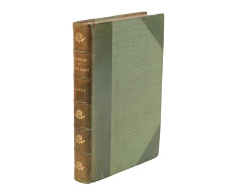
HARDY, THOMAS: A GROUP OF NOBLE DAMES London, Osgood, McIlvaine & Co., 1896 Vol XV of the first edition of Osgood, McIlvaine & Co.'s Wessex Novels. PRESENTATION COPY INSCRIBED BY THE AUTHOR on first blank “To Mrs Henry Allhusen…by command – and with affectionate regardsâ€. Frontispiece illustration and map of Wessex at end, with June 1896 preface by Hardy. 8vo., green half calf, spine in compartments with raised bands and rose tool in each panel, marbled endpapers, top edge gilt. Very slight rubbing to extremities and a little light browning.

Lot 24
HARDY, THOMAS: DESPERATE REMEDIES London, Osgood, McIlvaine & Co., 1896Vol XII of the Osgood, McIlvaine & Co.'s Wessex Novels. SIGNED BY THE AUTHOR on the half-title, dated Dec. 1913. Frontispiece of Knapwater House, map of Wessex at end, with February 1896 preface by Hardy. 8vo., very bright copy in original dark green cloth blocked in gilt, later green cloth drop-back box. Head of spine with small repair, bumped.Provenance: Booklabel of American collector Carroll Atwood Wilson.Reference: Purdy p.280

Lot 41
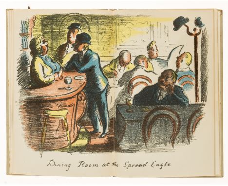
RACKHAM, ARTHUR - BARRIE, J.M: PETER PAN IN KENSINGTON GARDENS London, Hodder & Stoughton, 1906ONE OF 500 COPIES SIGNED BY THE ARTIST. 50 colour plates and other illustrations by Arthur Rackham. 4to., original full vellum blocked in gilt, yellow silk ties, front free endpaper with map of Kensington Gardens. Booklabels to front pastedown.

Lot 48
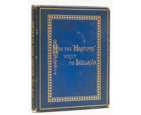
TROLLOPE, ANTHONY: HOW THE "MASTIFFS" WENT TO ICELAND London, Virtue & Co, 1878FIRST EDITION, issued privately. Frontispiece colour map, 14 lithographs by Mrs Hugh Blackburn, 2 mounted photographic plates. 4to., original blue cloth decorated in gilt and blind, all edges gilt, with the RARE DUST JACKET, not mentioned by Sadleir. Occasional spotting to plates, jacket with some soiling and slight chipping, a mark to upper cover and a small tear to bottom of upper fold.The Mastiff was a yacht belonging to John Burns, later Lord Inverclyde, in which Trollope sailed to Iceland. Burns paid for this private publication which was never issued for sale. Dust jackets on this work are very rare. Reference: Sadleir, Trollope, 51
Lot 23
COLLECTION OF MAPS,including early 20th century Ordnance Survey, facsimile antiquarian maps, modern geological maps, two framed relief maps, a large world map by Aprim Graphic, France, approximately 2m x 4m, and four publications on maps including Maps of Yorkshire (Whitaker H. Ed.) and re-issue of Bartholemew's Motorist's Road Maps pub. Sandpiper Books 2013Deacon's Chart poor, torn, browned and heavily worn
Lot 265
NO RESERVE London.- Whitbread's Reduced Ordnance Map of London, large folding map, some tears to foldlines, one large tear with tape repair, Index detached and loosely inserted, light browning, original cloth, printed paper label to upper cover, a little rubbed, [1880] § Extracts from the Court Rolls of the Manor of Wimbledon, scattered spotting, cracked hinges, previous owner's ink signature, original cloth, a little rubbed, 1866 § Geographers' A to Z Atlas of London, maps, original paper wrappers, faded, light spotting, [c.1947] § D'Elboux (R. H.) and Winifride Ward. The Registers of St. Dunstan in the Eaast London, scattered spotting, original cloth, slight bumping to corners and extremities, The Harleian Society, 1958; and others London, v.s. (c.25)
Lot 252
NO RESERVE Africa.- Moffat (Robert) Missionary Labours and Scenes and Southern Africa, first edition, colour Baxter print frontispieces, engraved vignette title, woodcut plates and illustrations, folding map, occasional heavy spotting, bookplate, previous owner's ink initials to title, contemporary diced calf, slight rubbing to corners and extremities, 1842 § The Life and Travels of Mungo Park, woodcut frontispiece, scattered spotting, bookplate, near contemporary calf, gilt, slight rubbing to corners and extremities, Edinburgh, n.d.; 8vo (2).
Lot 176
Folio Society.- Chaucer (Geoffrey) Troilus & Criseyde, illustrated by Peter Brookes, original morocco-backed boards, slipcase, a little rubbed, 1990 § Burton (Richard) The Source of the Nile: the Lake Regions of Central Africa, frontispiece and plates, folding map loosely inserted at end, original pictorial cloth, slipcase, 1993 § Walton (Izaak) The Compleat Angler, frontispiece and plates by Arthur Rackham, original pictorial cloth, slipcase, 2000 § Mitford (Nancy) Love in a Cold Climate, frontispiece and illustrations by Roland Pym, original pictorial cloth, slipcase, light spotting, 1992; and others Folio Society, v.s. (c.75)
Lot 237
Coward (T. A.) The Vertebrate Fauna of Cheshire and Liverpool Bay, 2 vol., first edition, frontispiece, plates, folding map at end, scattered spotting, original cloth, slight bumping to corners and extremities, 1910 § Carr (J. W.) The Invertebrate Fauna of Nottinghamshire, unopened, scattered faint spotting, original cloth, slight bumping to spine extremities, Nottingham, 1916 § Large (E. C.) The Advance of the Fungi, first edition, plates and illustrations, scattered spotting, bookplate, original cloth, light staining, chipping to spine extremities, 1940 § White (Gilbert) The Natural History of Selborne, frontispiece and illustrations by Claire Oldham, faint abrasion mark to front free endpaper, original cloth, dust-jacket, slight creasing to extremities, The Cresset Press, 1960; and others Natural History, v.s. (c.85)

Lot 56
NO RESERVE Annotated.- Nicolson (Joseph) & Richard Burn. The History and Antiquities of the counties of Westmorland and Cumberland, vol.1 only (of 2), engraved folding frontispiece map, 19th century ink marginalia, sometimes extensive, 19th century ms. notes, cuttings and prints loosely inserted, some spotting and staining, contemporary half calf, lower cover detached, worn, Printed for W. Strahan; and T. Cadell, 1777; and 3 others, annotated English works, v.s. (4) sold not subject to return.
![NO RESERVE Serrurier (L.) De Wajang Poerwå, Eene Ethnologische Studie. [Javanese Shadow Theatre, An Ethnological Study], addi](https://cdn.globalauctionplatform.com/ea73b1b4-4bd0-4cfd-a353-aeb300b3e1c4/76cc2ea7-87d7-4502-8a69-aeb300b5bd47/468x382.jpg)
Lot 136
NO RESERVE Serrurier (L.) De Wajang Poerwå, Eene Ethnologische Studie. [Javanese Shadow Theatre, An Ethnological Study], additional chromolithographed vignette title, 6 double-page plates, 2 folding tables and chromolithographed map, contemporary ink ownership inscription to pastedown, small marginal worming to last few ff., endpapers browned, hinges weak but holding, contemporary half roan, spine defective, rubbed, small worming to lower cover, unopened, Leiden, 1896; and c.85 others, including 13 vol. of The Play Pictorial and various ephemera, v.s. (c.85)

Lot 15
John Taylor Coleridge's copy.- Curtius Rufus (Quintus) De rebus gestis Alexandri Magni, regis Macedonum, libri superstites, edited by Henrik Snakenburg, engraved additional pictorial title, letterpress title in red and black and with woodcut printer's device, engraved folding map and 17 plates, of which 2 folding, foxing, some staining, particularly in index, contemporary calf, rebacked, preserving original richly gilt backstrip in compartments, corners restored, stained, [Dibdin 376], 4to, Leiden, Beman & Luchtmans, 1724; and 6 others, Classics, v.s. (7)⁂ 'This is the celebrated 'quarto Variorum' edition of Q. Curtius, by Snakenburg, which contains many valuable extracts from Bruno, Modius, Freinshem, and Cellarius' (Dibdin). Provenance: Sir John Taylor Coleridge (1790-1876), Park Cresecent, 1851, English judge and nephew of the poet Samuel Taylor Coleridge (ink inscription to front free endpaper).
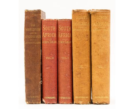
Lot 113
Trollope (Anthony) North America, 2 vol., 32pp. of advertisements dated October 1862 at rear vol. 1, half-titles, folding map (torn with tape repair, no loss, creased), bookplates, vol. 1 upper hinge with paper repair, lower cracked, initial pages with glue staining at gutter, very occasional light spotting or soiling, original cloth, spines sunned, spine ends a little torn, Chapman and Hall, 1862; South Africa, 2 vol., half-titles, folding colour map (with tear, no loss), double-page colour plate, 32pp. of advertisements dated November 1877 at rear vol. 2, vol. 1 gutter cracking at p.128, light spotting to initial pages, original cloth, spines toned, some light soiling and bumping, 1878, first editions [Sadleir 14, 48]; and a copy of West Indies and the Spanish Main, second edition, 8vo (5)
Lot 125
Trollope (Anthony) How the "Mastiffs" went to Iceland, first edition, colour map frontispiece, 14 lithographed plates and 2 mounted photographic plates, foxing throughout (including to plates), hinges weak, original blue cloth, gilt, some soiling, spine toned, extremities rubbed, g.e., [Sadleir 51], 4to, Virtue & Co., 1878.

Lot 261
World.- Griffis (William Elliot) Corea: the Hermit Nation, frontispiece, illustrations, folding map at end, previous owner's pencil signature, original cloth, gilt, a little rubbed, slight bumping to corners and extremities, 1882 § Lear (Edward) Views in the Seven Ionian Islands, limited facsimile edition, lithographed title and 20 plates, original cloth, gilt, Oldham, Hugh Broadbent, 1979 § Mackenzie (G. Muir) Travels in the Slavonic Provinces of Turkey-in-Europe, frontispiece, plates, 2 folding, 3 maps, of which 2 folding, scattered spotting, previous owner's ink inscription, contemporary calf, gilt, rubbed and worn, 1866 § Smythe (Frank S.) My Alpine Album, frontispiece, plates, map, original cloth, slight bumping to corners and extremities, dust-jacket, chipping and small loss to corners and spine extremities, 1940; and others, world, v.s. (45)

Lot 266
Sussex.- Arnold (E. C.) Birds of Eastbourne, colour frontispiece, plates and illustrations, scattered spotting, original cloth, gilt, Eastbourne, 1936 § Ball (Wilfrid) Sussex, colour frontispiece, plates, folding map, captioned tissue-guards, advertisements at end, original pictorial cloth, slight bumping to corners and extremities, A & C Black, 1913 § Prince (C. Leeson) Observations upon the Topography and Climate of Crowborough Hill, Sussex, presentation copy from the author with compliments slip pasted to front pastedown, plates and illustrations, original half-vellum, rubbed and worn, Lewes, 1898; and others on Sussex, including some duplicates, v.s. (c.70)

Lot 258
NO RESERVE Middle East.- Lawrence (T.E.) Revolt in the Desert, fifth impression, frontispiece, folding map, original buckram, slight bumping to corners and extremities, 1927; The Mint, first trade edition, scattered spotting, original cloth, bumping to spine extremities, dust-jacket, rubbed and worn, tear to spine, loss to spine extremities, 1955; and others Lawrence, 8vo & 4to (8).
Lot 260
World.- Cave (Henry W.) Golden Tips: a Description of Ceylon and its great Tea Industry, portrait frontispiece, folding map, plates and illustrations, advertisements at end, bookplate, original pictorial cloth, gilt, rubbed, bumping to corners and extremities, 1900 § Hunt (John) The Ascent of Everest, first edition, frontispiece, plates and illustrations, previous owner's ink inscription, original cloth, slight bumping to spine extremities, price-clipped dust-jacket, small tears and chipping to corners and spine extremities, 1953 § [Aitkin (Edward Hamilton)] The Tribes on my Frontier, frontispiece, vignette title, plates and illustrations, cracked hinges, original pictorial cloth, a little rubbed, bumping to corners and extremities, 1884 § [Vincent (J.)] An Atlas of Ancient Geography, 22 hand-coloured engraved double-page maps, scattered spotting, contemporary half-calf, printed paper label to upper cover, rubbed and worn, bumping and small loss to corners and spine extremities, 1829; and others World, v.s. (c.70)
Lot 181
Ardizzone (Edward).- Gorham (Maurice) The Local, first edition, 14 colour lithograph plates by Ardizzone, one double-page, original pictorial boards, spine a little browned and slightly bumped at head, 1939 § Freeman (C. Denis) and Douglas Cooper. The Road to Bordeaux, first edition, illustrations by Ardizzone, map endpapers, original cloth, dust-jacket worn and repaired to verso, Cresset Press, 1940 § Bloomfield (Paul) The Mediterranean, An Anthology, first edition, illustrations by Ardizzone, original cloth, dust-jacket, 1935; and a large quantity of others by and/or illustrated by and/or with dust-jackets designed by Ardizzone, v.s. (c.170, 3 boxes)
Lot 267
Warwickshire.- Dugdale (Sir William) The Antiquities of Warwickshire, 2 vol., second edition, engraved plates and maps, some folding or double-page, extra-illustrated with a few engraved plates from other works, all plates with small square of paper on verso obscuring removal of library stamp (seemingly quite old), similar treatment to a few text leaves, contemporary calf, rebacked and recornered, worn, 1730; The Antiquities of Coventre, engraved frontispiece (folding at edge), map and 6 plates, some after W. Hollar, illustrations, some light offsetting, contemporary red half morocco over marbled boards, Coventry, Printed by J. Jones, 1765 § Knowles (Rev. E.H.) The Castle of Kenilworth, first edition, 4 plans, 24 mounted photographic plates, some foxing and marginal browning, modern calf-backed cloth, Warwick, 1872; and 17 others, Warwickshire, including vol.1-8 of the Victoria County History (ie without the Index vol.), folio and 4to (21)
Lot 256
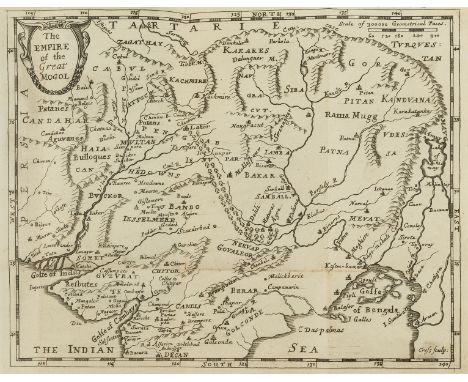
India.- Bernier (Francois) The History of the Late Revolution of the Empire of the Great Mogol: together with the Most Considerable Passages for 5 Years Following in that Empire, translated by Henry Oldenburg, 2 parts in 1 vol., first edition in English, folding engraved map at end, title within double-rule border, woodcut initials, title browned at head, but a good, clean copy otherwise, bookplate to pastedown, detached contemporary sheep, upper cover detached from spine and lower cover, some light wear to extremities, [Wing B2043], small 8vo, sold by Moses Pitt at the White Hart in Little Brittain, 1671.⁂ Scarce, with a section on Kashmir and map at the end covering the Indian peninsula as far south as Golconda.Provenance: Fintray House Library (bookplate).
Lot 108
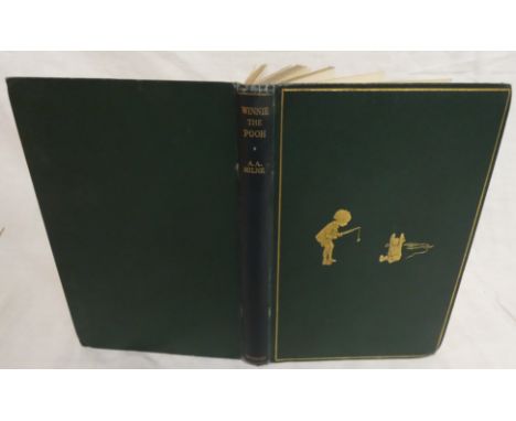
MILNE A.A. Winnie-the-Pooh. Illus. by E. H. Shepard. Orig. green cloth gilt. First Edition, 1926.Condition report:Ownership inscription to front map endpaper.Glue mark to front board above figures. Folding to top and bottom of spine and along edges. Pages misaligned across fore-edge. Owner's name in pencil above front map. Pages generally clean with some light yellowing throughout. Ingrained dirt on pages 80-81. Pages separating from spine towards end of book.

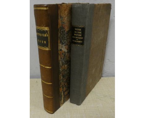
Lot 147
DENHOLM JAMES. A Tour to the Principal Scotch and English Lakes. Fldg. eng. map. Rebacked quarter calf, old marbled brds., internal browning & foxing. Glasgow, 1804; also Thomas Wilkinson, Tours to the British Mountains with the Descriptive Poems of Lowther and Emont Vale, orig. brds., neatly rebacked, 1824. (2)

Lot 161
NOLAN E. H. The History of the British Empire in India. 8 vols. Eng. plates & maps. Royal 8vo. Orig. red cloth gilt, rather worn; also others, Indian interest.condition:Each volume has eight plates and one map (volume 8, one of the plates is an engraved title).Fairly poor condition. One or two plates detached.


Lot 188
WARBURTON JOHN. Vallum Romanum or The History & Antiquities of the Roman Wall. Fldg. eng. map & eng. plates. A further fldg. eng. map slipped in (a Survey of the Country between Newcastle & Carlisle by N. Hill). Quarto. Well rubbed dark half morocco. Ownership inscription of John Grey of Dilston, formerly in the library of Rev. John Hodgson. 1753.


Lot 90
IRVINE W. FERGUSSON. A Short History of the Township of Rivington in the County of Lancaster. Fldg. map, plates & illus. Quarto. Rebacked & recased orig. cloth. Ballantyne Press, 1904; also Tom C. Smith, A History of Longridge & District, fldg. map, plates & pedigrees, Preston, 1888 & 2 vols. re. Leeds churches. (4).

Lot 94
TUNNICLIFF WILLIAM. A Topographical Survey of the Counties of Stafford, Chester & Lancaster. Each county having a folded eng. map & eng. armorial plates with some of the shields blank (8 for Staffordshire & Chester, 16 for Lancashire). Rebound brds. Nantwich, 1787. Unusually, the final leaf is a request by the author for future employment in "the place of Steward to a Nobleman or Gentleman".

Lot 96
PITT WILLIAM. A Topographical History of Staffordshire including its Agriculture, Mines & Manufactures ... With a Succinct Account of the Rise & Progress of the Staffordshire Potteries. No map. Subscriber's list. Diced calf. Newcastle-Under-Lyme, 1817; also William White, History Gazetteer & Directory of Staffordshire, rebacked calf, 1851 & 3 others. (5).


Lot 51
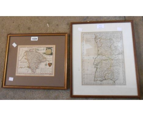
Ogilby John strip map, plate nr 72, The Road from West Chester to Cardiff com Glamorgan from West Chester to Wrexham and on to Cardiff via Sellatyn, Llanfylen, llanvelling, Vunneth Llanbader, framed and glazed together with another early map by Mordant Robert - Rutland Comitatus Rotelandiae Tabula Nova & Aucta, boundary lines coloured in yellow ink, approx 43 x 33 cms, both framed and glazed.

Lot 53
Speed John - Map of Bedfordshire, embelished with four cartouches including a street map and Coat of Arms of the Earls and Dukes of Bedford, with title and scale. First published in 1611, hand coloured, approx 51 x 38.5 cms, framed and glazed. Bowen (Emanuel) Accurate Map of Berkshire Divided into its Hundreds, circa 1770's copper plate map with hand colouring, with ornamental title and cartouche, printed for Bowles & Carver approx 69 x 55 cms, framed.


-
109182 item(s)/page