

Brabourne (Wyndham W. Knatchbull-Hugessen). The Birds of South America, 2 volumes. (Text/Plates), 1912 & 1917, additional half titles, volume 2 with thirty-eight fine hand-coloured lithographic plates after H. Gronvold (complete), descriptions of plates bound at rear, occasional spotting to a few plates, double-page colour map to volume 1, volume 2 with t.e.g., publisher's cloth gilt, spines slightly faded, 4to, Zimmer, Ayer Ornithological Library, p. 85/6. As projected, this work was to have comprised 16 volumes with 400 plates, but the death of the senior author terminated the publication after the issue of the present volume, containing only the list of species. A series of 38 of the plates intended for this work was issued subsequently, under separate authorship and title, as "Illustrations of the Game Birds and Waterfowl of South America," by H. Gr”nvold, 1917. (2)
We found 109198 price guide item(s) matching your search
There are 109198 lots that match your search criteria. Subscribe now to get instant access to the full price guide service.
Click here to subscribe- List
- Grid
-
109198 item(s)/page

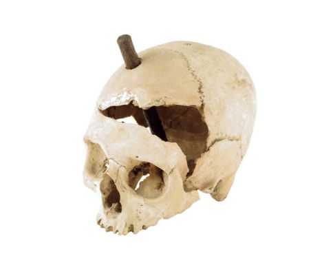
An early female skull, with a contemporary wound to her cranium and with an iron stake discovered with the skull, together with a contemporary newspaper cutting, map and typed report on card, 14.3cm high, 12cm wide. Provenance: The skull was discovered in 1951 by workmen excavating foundations on Brook Road, Kinson, Bournemouth. It was found at a depth of about two feet with tree roots growing through it. It is believed to be of a woman between thirty-five and forty-five years old. The skull is possibly three hundred years old and the woman was subject to a deliberate and gruesome death. There is a small hole to the rear of the hole where the iron stake was found and it seems that a first attempt was abortive due to the resistance of the inter-parietal suture. Why would a female be subject to such an attack? Perhaps she was a witch and was tortured or perhaps she was an informer on the pirates who used Kinson Church tower to store their contraband.


An 18th century indenture paper bearing numerous wax seals, a 19th century map of the country around Liverpool (af), a quantity of largely 20th century coinage, two whistles to include an A.R.P. J. Hudson & Co of Birmingham example, a Liverpool Council of Education medal, a boxed Zurich sports watch, football cards, postcards/Christmas cards etc. CONDITION REPORT Coinage includes 2 silver Dollars and an 18th Century coin.


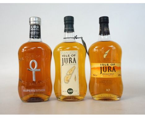
3 ISLE OF JURA A selection of Isle of Jura Single Malt Scotch Whiskies. ISLE OF JURA 10 YEAR OLD. 70cl. 40% abv. With old map label. In original carton. Level bottom neck/ top shoulder. Very good condition. ISLE OF JURA 10 YEAR OLD. 70cl. 40% abv. Old-style label & packaging. In original carton. Level bottom neck/ top shoulder. Excellent condition. 2 bottles. ISLE OF JURA SUPERSTITION. 70cl. 43% abv. The smoky version of the Jura Malt. In original carton. The ankh on the bottle is damaged. Good condition otherwise. 3 bottles.

SELECTION OF MINIATURES 16 bottles. A selection of Malt & Blended Whisky miniatures, including: Dalwhinnie 15 Year Old (43% abv); 2 x Cragganmore 12 Year Old (40% abv); Lagavulin 16 Year Old - White Horse (43%); Isle of Jura 10 Year Old (40%) 3cl; Blair Athol 8 Year Old (40%); Talisker 10 Year Old - Map Label (45.8%); Oban 14 Year Old (43%); Tamdhu 10 Year Old (40%); Glen Moray 12 Year Old (40%); Kinghorn Bowling Club Centenary Blend (40%); Black & White Blended (43 degree G.L.); Bell's Extra Special (40% abv); Bell's Extra Special 8 Year Old (40%); Cutty Sark Blended Scots Whisky - with Methil Bowling Club 100th Anniversary sticker; VAT 69 Blended Scotch Whisky (43%). All bottles 5cl unless otherwise stated. See image for fill levels.


Paul Brickhill - The Dambusters, single volume; together with World War II War Revision 1940 map of Exmoor; Royal Air Force golden jubilee souvenir book; and various buttons etc Condition Report / Extra Information The Dam Busters - reprinted October 1951, with Z 5028 on dust jacket flap, inscribed in pen 'From Maureen Margaret Hilary Gwen, January 1952'


William White, 'Whites Lincolnshire' Sheffield, 1872. Hardcover. Green cloth, gilt lettering, map, William Andrews, 'Bygone Lincolnshire' Hull: A Brown & Sons, 1891, hard back in green cloth boards, half-calf in green/gilt leather, with ends of spine worn and eaten, and 'Lincolnshire Topographical Society' W. & B. Brooke, Lincoln, 1841 1842, hardcover. (3)
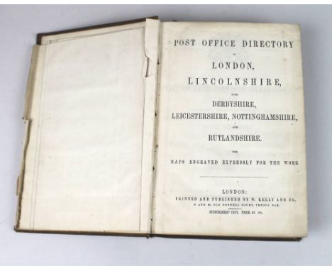
A subscribers copy of the 'Post Office Directory', Kelly & Co, London, 'Lincolnshire with Derbyshire, Leicestershire, Nottinghamshire and Rutlandshire,1849, original faded red gilt cloth on board, of two thousand and eighty seven pages, including map, light foxing and age discolouration due to the poor paper stock used.


AN EARLY 20TH CENTURY ALBUM OF PENCIL DRAWINGS, mostly cottages in rural landscape and figures, page size 23cm x 33cm, together with a MAP OF ENGLAND AND WALES by "Geographia Ltd. of Fleet St., London", printed paper laid on fabric, for wall hanging, rolled with ebonised rod ends, 120cm x 100cm

AFTER NICOLAUS VISSCHER (1618-1709) "Novi Belgii", coloured engraved map with long cartouche lower right, the map decorated with various animals native to North America, 47 cm x 57 cm CONDITION REPORTS Paper appears to have been "greyed". Some old folds in the paper. Limited signs of foxing but present in some small sections. Unable to see back. Frame with some small chips and general signs of wear and tear. Philadelphia is present on the map - see images.


DAVID ROBERTS "Roberts' Sketches in Egypt and Nubia with historical descriptions by William Brockedon FRS, lithographed by Louis Haghe", published Francis Graham Moon, Threadneedle Street, publisher in Ordinary to Her Majesty, 1846 - 1849", three volumes, unbound (Provenance: formerly the property of Richard Hungerford Pollen Bart), 66 cm x 47 cm CONDITION REPORTS All three volumes unbound - Vol 1 - all 42 plates present, Vol 2 - all of the 44 plates present except plate 24 Pyramids of Geezeh and 44 map of the Valley of the Nile, Vol 3 all of the 38 plates present except plate 7 Ruined Mosques in the West of the Citadel. Condition of plates variable but basically sound, sample images various attached. Due to the variable condition of the plates and script its rarity and value we would respectively suggest a viewing of the lot in person and whilst most of the image areas of the plates although a little brown in colour in sound there is much foxing throughout. Further to the catalogued provenance - please note the Richard Hungerford Pollen Bart was an original subscriber to this vol. and companion to David Roberts during his travels - this lot and 221 come form the estate of Pollen by descent to the present vendor.

"Lizars' Edinburgh Geographical General Atlas: Containing map of every Empire, State and Kingdom; with a Tabular View of the Heights of The Great Mountain Chains", published Edinburgh by W. H. Lizars, 3 St. James Square, bears paper label to top right hand corner "127", black cloth board bound CONDITION REPORTS Binding in poor condition although maps complete in various condition, frontest piece and map index with much foxing and discolouration throughout remained of vol. With mirror images / imprint from previous pages throughout - see images for detail


AFTER JOHANNES BLAEU (1596-1673) "Glocestria Ducatus Vulgo Glocestershire from Theatrum Orbis Terrarum Sive Atlas Novus", published 1663 (possibly later reproduction), with Dutch text verso, the map later hand-coloured with large decorative title cartouche to the lower right corner, twelve shields to the upper left featuring ten family coats of arms with two left blank, 40 cm x 50 cm CONDITION REPORTS Various signs of foxing throughout and some yellow marks. Colours are generally good. Paper is not flat throughout. Frame is showing signs of wear and tear. Some pencil marks verso to the top right hand corner. Signs of some colour leaking through to the back. Foxing all over the back as per the front and some yellow marks and greyed areas.

WH LIZAR "A Modern Ancient General Atlas Comprehending all the Empires, States, etc in the World Constructed from the Most Correct Authorities and containing all the recent discoveries of Parry, Ross, Franklin etc etc", including New Holland (Australia) printed Edinburgh, for D Lizars 5 St. David Street and C.B Whittaker London, in marbled boards CONDITION REPORTS Binding basically sound although with knocks and scratches throughout, three maps missing including Turkey (16) Sweden and Norway (17) and Graceia Antiqua (34) all remaining maps with some discolouration and areas of repairs to several, reverse of West Indies map has child like pencil scribbling's otherwise map in reasonable although mostly discoloured order.

JOHN CARY "New Map of England and Wales with part of Scotland ...", published June 11th 1794 with dedication "To the Rt Philip Earl of Chesterfield and Baron Stanhope and Thomas Baron Wallsingham, Postmasters General and Members of His Majesty's Most Honourable Privy Council ...", one volume, brown leather binding mostly missing


American Interest - Great Emigration House of Representatives report titled "Military Posts- Council Bluffs to the Pacific Ocean (rep No 830), inscribed Mr Rupert Bartlett, New York, to Sir J Alexander 14th Regt., the full calf binding titled in gilt "Oregon" with folded map titled "Map of the United States Territory of Oregon, West of the Rocky Mountains - exhibiting the various trading depots or forts occupied by the British Hudson Bay Company; Colonel J J Abert 1838; together with a letter and transcription of the letter from G Wetherall to Sir Janes Edward Alexander dated 6th July (18)43 CONDITION REPORT: Major-General Sir James Edward Alexander of Westerton was a celebrated soldier and explorer

-
109198 item(s)/page