We found 109198 price guide item(s) matching your search

Refine your search

Year

Filter by Price Range
  • List
  • Grid
  • 109198 item(s)
    /page

Lot 156

Africa.- Harris (William Cornwallis) The Highlands of Æthiopia, 3 vol., half-titles, lithographed frontispieces (2 tinted, 1 hand-coloured), chromolithographed dedication, engraved folding map (loose, small tear, neatly repaired), ink inscriptions, occasional light spotting, original cloth, rebacked with original spines laid down, spines browned, slight bumping to corners, [Czech p.72; Abbey Travel 290] 1844 § Bland-Sutton (J.) Man and Beast in Eastern Ethiopia, illustrations, original pictorial cloth, slight bumping to extremities, [Czech p.18] 1911; first editions; and another, similar, 8vo (5)

Lot 89

White (Rev. Gilbert) The Writings of Gilbert White of Selborne, edited by H.J.Massingham, 2 vol., number 248 of 850 copies, fine wood-engraved pictorial titles and head- & tail-pieces by Eric Ravilious, folding map, original buckram, gilt, t.e.g., others uncut, spines gilt with animal motifs and slightly faded (as usual), t.e.g., others uncut, together in marbled board slip-case, [Dreyfus 114], 8vo, Nonesuch Press, 1938.

Lot 54

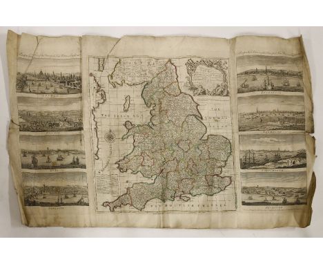
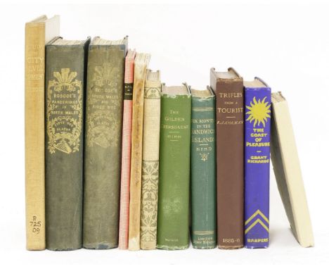
Ireland (Samuel) [A set of Picturesque Views], comprising: Picturesque Views, with an Historical Account of the Inns of Court, in London and Westminster, half-title, 21 hand-coloured aquatint plates, errata leaf at end, one or two plates shaved at fore-edge, contemporary diced russia, gilt, rebacked preserving old gilt spine, 1800; A Picturesque Tour through Holland, Brabant, and part of France, 2 vol., first edition, engraved vignette titles and 45 plates, contemporary tree calf, gilt, rebacked preserving old gilt spines with red and green roan labels, [1790]; Picturesque Views on the River Thames, 2 vol., half-titles, additional engraved pictorial titles, 2 maps and 52 plates, errata leaf at end of each vol. and advertisement leaf end vol.2, contemporary diced russia, gilt, rebacked with gilt spines, 1792; Picturesque Views on the River Medway, leaf of verse, additional pictorial engraved title, map and 28 plates, contemporary mottled calf, gilt, rebacked with gilt spine and green morocco labels, 1793; Picturesque Views on the Upper, or Warwickshire Avon, additional pictorial engraved title, map and 31 plates, errata leaf at end, short tear to upper margin of 2F4, contemporary blind-stamped red straight-grained morocco, spine gilt (slightly faded), upper joint repaired, 1795; Picturesque Views on the River Wye, lacking half-title but with errata slip, engraved map and 31 plates, contemporary red straight-grained morocco, gilt, spine gilt (slightly faded), 1797 § Harral (Thomas) & Samuel Ireland. Picturesque Views on the Severn, 2 vol. in 1, 52 lithographed plates, contemporary calf, gilt, rebacked preserving old gilt spine with green roan labels, corners repaired, 1824, together 7 works in 9 vol., first editions, most plates aquatints printed in sepia, wood-engraved illustrations, plates with marginal foxing or light browning, some offsetting, occasional spotting to text, a little rubbed, [second item Abbey, Travel 184, the rest Abbey, Scenery 207, 430, 428, 427, 544 & 429], 8vo (9)

Lot 142

Africa.- Churchill (Winston Spencer) London to Ladysmith via Pretoria, 3 folding maps (1 colour), 4 plans, ink inscription, 34pp. advertisements at end, a little rubbed, slight bumping to corners and extremities, 1900; My Early Life, frontispiece, plates, 1 folding map, ink inscription, small water-staining to top edge of first few leaves, occasional light foxing, rebacked with original spine laid down, spine faded, 1930; My African Journey, frontispiece, plates (lacking 2), maps, occasional spotting, abrasion mark to front pastedown, cracked hinges, spine faded, chipping to extremities, 1908; first editions, original cloth; and another by the same, 8vo (4); sold not subject to return.

Lot 192

Africa.- Weule (Dr. Karl) Native Life in East Africa, first edition, frontispiece, plates and illustrations, folding map at end, original cloth, 1909 § Playne (Somerset) East Africa (British). Its History, People, Commerce, Industries, and Resources, plates, original pictorial morocco, 1908-9 § French-Sheldon (M.) Sultan to Sultan, first edition, plates and illustrations, original cloth, slight bumping to spine extremities, 1892; and 15 others, East Africa, v.s. (18)

Lot 173

Africa.- New (Charles) Life, Wanderings, and Labours in Eastern Africa. With an Account of the First Successful Ascent of ... Kilima Njaro, and Remarks upon East African Slavery, first edition, advertisement leaf, half-title, engraved portrait frontispiece, 10 tinted lithographed plates, folding map (small tear), original pictorial cloth, spine faded, bumping to spine extremities, [Neate N14], 8vo, 1873. ⁂ "New made the second serious attempt on Kilimanjaro in 1871, reaching c.15,000 ft at the then snowline; he described the snow as 'lying on ledges of rock in masses, like large sleeping sheep." Neate

Lot 195

Big Game.- Buxton (Edward North) Two African Trips, frontispieces, folding map in pocket at end, spine very lightly browned, slight bumping to spine extremities, 1902 § Chapman (Abel) On Safari, frontispiece (lightly spotted, small damp-stain to corner), illustrations, ink inscription, rebacked with original spine laid down, 1908; first editions, plates, original decorative cloth, [Czech, p.30 & 35]; and 11 others, Big Game, 8vo, (13)

Lot 226

Japan.- [Map of Tokyo], folding colour woodcut map, on four conjoined sheets, overall c,720 x 760mm., title and text in Japanese, some light foxing and staining, wear to folds causing a few splits and holes (some repaired), [?Tokyo], [c.1826].

Lot 135

Africa.- Boyes (Maj. John) John Boyes King of the Wa-Kikuyu, plates, 1 map, ink inscription, occasional spotting, original cloth, slight bumping to extremities, 1911; The Company of Adventurers, plates, occasional foxing, modern half calf, 1928 § Roscoe (John) The Baganda, illustrations, 3 folding maps and plans, original cloth, slight spotting to upper cover, slight bumping to extremities, 1911; first editions, frontispieces, [Czech p.21; Hosken p.171]; and 11 others, Boyes and Roscoe, 8vo (14)

Lot 215

Gibson (John) Atlas Minimus, or a New Set of Pocket Maps ... of the known World ... revis'd, corrected and improv'd by Eman: Bowen, first edition, engraved title, frontispiece, preface leaf, index leaf and 52 engraved maps hand-coloured in outline (16 relating to America), 1 map with very small burn tear in margin not affecting map, slightly browned, early ink inscription on front free endpaper, contemporary polished calf, red morocco label on spine, 2 very small wormholes at tail of spine, [Phillips Atlases 621; Roscoe J146 (2)], 16mo, J. Newbery, 1758.

Lot 177

Africa.- Pringle (M. A.) Towards the Mountains of the Moon, first edition, half-title, folding map, some abrasion marks to endpapers, ink inscription, original pictorial cloth, browned spine, bumping to corners and extremities, 1884; and 2 others, similar, 8vo (3)

Lot 5358

Militaria - Cold War/U.S.S.R and WW2 - Soviet Army Uniform [1961], Restricted [...] information [...], issued by the War Office, sixteen-fold poster, 75cm x 100cm; ABCA Map Review: "One Good Strong Heave", No. 61, From February 26th to March 11th, 1945, Printed for H.M. Stationery Office, 76cm x 102cm (2)

Lot 5325

Boxes and Objects - a St John's Ambulance, British Rail wall mounted first aid box with contents; another metal box; an Official Railway Map of Wales, 1926; others, pictures and prints, etc

Lot 5340

Pictures and Prints - Thomas Moule, c.1851, Derbyshire, engraved map, framed; another Lancashire; other engravings, etc (7)

Lot 5452

H Moll, after, map Derbyshire, hand coloured, 32.5 cm x 20cm; W Gilbert, (20th century), fishing the river bend, oil on board, signed, 30cm x 40cm (2)

Lot 395

A reproduction of The Drake Silver Medal Map Michael Mercator 1589, limited edition National Maritime Museum

Lot 32

Joe Rodeo Master chronograph diamond and stainless steel gentleman's wristwatch, ref. JJM8, no. 0707, world map dial with date aperture at the four position, triple subsidiary dials and red centre seconds, diamond bezel, quartz, 46mm (at fault) (94VVXC) . Condition Report: . Movement - not functioning, possibly requires a new battery but untested and not guaranteed. Dial - good. Glass - light marks. Hands - good. Case - surface marks. Crown - at fault, stem broken. Strap - at fault, broken and missing rubber strap. . Condition reports are provided for guidance only. Please view images and further information can be obtained upon request. Gardiner Houlgate do not guarantee the working order or time accuracy of any lots. Due to the opening of the wristwatch case backs, it is recommended watches are re-sealed by professional technicians to ensure any stated water resistance is retained.

Lot 1306

WWII British War Map "New War Map of the Western Front" showing the positions of the Maginot Line and the Siegfried line in full detail. Produced by Alexander Gross and is full colour.

Lot 1379

German WWII Flag Finial, Red Cross (Rotes Kreuz) sack "Lazarett Berlin 1943", and 1945 dated Map of the Drosendorf area.

Lot 94

TWO ANTIQUE FOLDING BARTHOLOMEW MAPS - WILTSHIRE AND BRISTOL BA74. TOGETHER WITH A FRAMED COAL AND ROPER MAP OF BRECKONSHIRE c.1840, A MOUNTED MAP OF CAERMARTHENSHIRE BY DUGDALE c.1845, AND A 1940 WAR OFFICE OS MAP OF WOLVERHAMPTON

Lot 80

A WORLD WAR ONE ERA BRASS MAP RULER TOGETHER WITH A LEATHER CASED CLINOMETER

Lot 83

TAMWORTH INTEREST, a 19th Century John Peel Tamworth Election canvassing leaflet, circa 1865, framed and glazed, approximately 25cm x 19.5cm, together with a 19th Century hand tinted map of Tamworth showing Old Municipal Boundaries, proposed Boundary, etc, framed and glazed with paperwork verso, approximately 25cm x 20cm and four frames of cigarette cards (6)

Lot 212

Robert Morden hand coloured map of The Bishopric of Durham, 42 x 36 cm

Lot 361

After R Gray, a map of Hindoostan, printed on linen, 57 x 57cm, together with England and Wales after J Barwick, also on linen, and a linen printed broadsheet 'The Several Stages of a Man's Life....(3)

Lot 199

Buckinghamshire, Blaeu (Joan), Buckinghamiensis Comitatus, circa 1645, a hand coloured map with text verso, 42.5 x 28cm

Lot 129

THOMPSON, George: Travels and Adventures in Southern Africa... comprising a view of the present state of the Cape Colony, with observations on the progress and prospects of the British emigrants. S. & R. Bentley for Henry Colburn, 1827, First edition, 4to. PP: xviii, (ii), 493. Complete with one folding lithographed map, Two lithographed plans (one double-page, one folding), Twenty aquatint plates (one double-page) and seventeen wood engravings in the text. Cont. full mottled calf and later spine; little rubbed; occasional foxing and the odd small tear.

Lot 21

Lotterus, Tobias Conradus; Tobias Lobeck: Atlas Geographicus Portatilis, XXIX Mappis Orbis Habitabilis Regna Exhibens. Augsburg, G. Eichler / Tobias Lobeck, n.d. c1762. With double page engraved title page, double page engraving, TWO double page Globes, Plus 29 Maps (the Globes and maps are all hand coloured). Contemporary full embossed leather; spine little chipped; one map with small tear (without loss); otherwise VG.

Lot 8

John Speede CUMBERLAND, HER ANCIENTE CITY OF CARLILE, 1610 hand-coloured map, and glazed, 38 x 50cm

Lot 130

Tuckey, Captain James K: Narrative of an Expedition to explore the River Zaire, usually called the Congo, in South Africa, in 1816.… J. Murray, 1818, First edition. Large folding Map Plus 13 Plates (one hand-coloured). 4to. PP: (viii)including half title and title, Lxxxii (Introduction), 498. Later half leather over marbled boards and new endpapers; very light remains of stamp to verso of title page; contents page torn and with some repair (but complete); some browning and foxing.

Lot 17

1- Wyld’s new plan of London and its vicinity. 1874, colour linen backed 40 sections folding (116 x 81.5 cms); small tear to fold; 2- Philip's Tape Indicator map of London. N.d. c1920, colour linen backed folding (62 X 90cms.); lacking tape; 3- Ravenstein, E G: The Oarsman's and Angler's Map of the River Thames. James Reynolds, nd, c1880; colour linen backed folding into 25 sections (244 X 16 cms.); 4- A New Map of England and Wales with part of Scotland.. T. Doody, Newport, Shropshire, 1855. Colour linen backed folding into 20 sections (78 X 64 cms.), with a vignette and in original covers; G+; Plus 8 other ordnance survey maps and 2 London Underground maps, 1947 & 1959. (14)

Lot 5

Benjamin Cole A CITY OF LONDON WARD MAP OF BREAD STREET WARD AND CORDWAINERS WARD Street map, 1755, 24.5 x 36.5cm, together with a further similar Benjamin Cole BROAD STREET WARD AND CORNHILL WARD Street map, 1755, 35.5 x 47cm (2)

Lot 127

VENEGAS, Miguel; Johann Christoph Adelung (transl.): Natürliche und bürgerliche Geschichte von Californien; Three volumes bound in one. Lemgo: Meyer, 1769-70, first German edition. With a folding map of California. PP: 184; 198; & 176. Small 4to. rebound in pattered boards and new endpapers; worm damage to bottom margin of the last volume (away from the text); few small worm holes to the folding map. ((The introduction contains a discussion of the geographical concept of California as an island, which does not appear in other editions.)).

Lot 227

JOSEPHUS, Flavius: 1- The Whole Works. For The Proprietors, 1795, new edn. corrected; All plates present; PP: 795, (i). Cont. full calf; rubbed and hinges cracked; 2- The works. For Abel Roper, 1676. With a double-page map and illustrations. PP: 854, + table. Cont. full leather; covers rubbed and detached. (2)

Lot 166

FOXE (JOHN): [Book of Martyrs]. The Firste [-Second] Volume of the Ecclesiasticall History, Contayning the Actes [and] Monumentes of Thinges Passed in Every Kinges Time, in This Realme, Especially in the Churche of England Principally to be Noted]. Two volumes bound in one. One colophon present at the end of the volume (cut and laid down), reads: John Daye, 1576. This is the third edition (printed in Foxe's lifetime). Lacking the title pages, all before 'Index to table' and other pages. Collates as follows: PP: 1-770 ( lacking 771/2 -title to second volume; 773-1428; 1447-1820; 1833-1868; 1857-1966(catchword correct); 1931-1932; 1969-2004 lacking 2005-8 also the preliminary (23) and (16)at end. Present: 138 pages with one or more illustrations (including the Map of England), plus part of one plate of four?. Please also note the following faults: PP757/8 torn with small loss; 763/4 margin torn; 1053/4 margin torn, without loss to text; 1059/60 margin loss; 1069/70 margin loss (not affecting text). SOLD NOT SUBJECT TO RETURN.

Lot 16

Mogg, Edward: London in Miniature, with the surrounding villages, an entire new plan , in which the improvements both present and intended are actually reduced. E. Mogg, Jan, 1812. Folding engraved map with contemporary hand-colouring; c 54X95 cms.

Lot 182

1- Nightingale, Joseph: Religions and Religious Ceremonies of All Nations. 1821, 1st. with folding map plus many plates; PP647, 16(ads.). Leather backed boards; some browning; 2- Round London: an album of pictures from photographs of the chief places of interest in and round London. George Newnes, 1896 Oblong Folio; original pictorial covers; vg; 3- Bow Bells. A Weekly Magazine of General Literature. John Dicks, 1863. Folio; with large folding frontis and many illustrations; half leather; G+; 4- Thompson, C J S: 2 TITLES: Mystery & Romance of Astrology, 1929, 1st. dw; & Mystery & Romance of Magic. 1929, 1st; both vg. (5)

Lot 13

1- MUDGE, William: PART THE FIRST OF THE GENERAL SURVEY OF ENGLAND AND WALES CONTAINING THE WHOLE OF ESSEX AND A PORTION OF THE ADJOINING COUNTIES DONE BY THE SURVEYORS OF HIS MAJESTY'S ORDNANCE, UNDER THE DIRECTION OF Lt. Coll. MUDGE OF THE ROYAL ARTILLERY F.R.S. Four sections, linen backed and in the original leather box; n.d. C1805. Each section has its borders lined and sewn; 2- Kelly’s Directory of Essex, 1886. front cover and first few page detached; lacking the map? (2)

Lot 203

1- The Contents, Virtues, and Uses of Nevil-Holt Spaw-Water, Further Proved, Illustrated, and Explained, from Experiments and Reason. Mr. Corbett, 1749, 2nd. edn. with additions. PP: viii, 68; BOUND WITH: A Treatise on the Nature, Properties, and Medicinal Uses of the Waters of Pyrmont, Spa, and Seltzers. Also of the Malvern Waters. for W. Owen,1762, 1st. edn. PP: 32, (iv)ads. Later full leather; 2- Walker, J: An Essay on the Waters of Harrogate and Thorp-Arch in Yorkshire.. for J. Johnson.., 1784, 1st. edn. PP: viii, 208. Later full leather; Little age toning; VG+; 3- Feltham, J: A Guide to All the Watering and Sea-bathing Places; With A Description of the Lakes; A Sketch of a Tour in Wales; and Itineraries. Richard Phillips, n.d. Frontis panorama of Bath dated 1808. With 55 of 57 plates & maps (lacking view of Hastings & map of Ramsgate); 4- Another copy; lacking all the plates & maps; 5- Moncrieff, W T: The Visitors' new Guide to The Spa of Leamington Priors, and its Vicinity. Leamington: W. G. Elliston, 1818; with folding map (lacking the folding plan); binding as above; 6- Hargrove, E: History of the Castle, Town and Forest of Knaresbrough, with Harrogate & its medicinal springs; Knarebrough, for W. Langdale, 1821, 6th. edn. With folding colour map; A/F; 7- Sunderland, S: Old London's Spas, Baths, and Wells. With 36 ill. John Bale.. 1915, 1st edition; SIGNED PRESENTATION COPY. Rebacked with leather spine; 8- Tuer, A W: Luxurious Bathing: A Sketch. With 8 engravings by T Ellis. Field & Tuer, 1880, 4th. edn. Full vellum; soiled & warped. (8)

Lot 137

Narrative of the Expedition to the Baltic: With an Account of the Siege and Capitulation of Copenhagen; including the surrender of the Danish fleet. By an Officer employed in the Expedition. Brettell for W. Lindsell, 1808, First edn. With a folding coloured plan of Copenhagen and a folding coloured map of 'The Sound' with account of the Siege of Copenhagen, including the surrender of the Danish Fleet; PP: xi, 307. Original paper boards; rubbed and lacking spine (now replaced); Otherwise vg. (Scarce)

Lot 18

SCOTLAND: 1- New Road Map of Scotland With All The Lines of Railway, Canals, etc. Edinburgh, W. Lizars, n.d. c1845; colour linen backed 36 sections folding (87 X 58 cms); in original gilt pictorial covers; covers worn; map vg; 2- Smith, W H: Tourist’s map of Scotland. N.d. colour folding linen backed (76 X 58 cms.); 3- Brydone's Views of Edinburgh. Edinburgh, n.d. c1858; 13 fine linen backed views, in original publishers leather backed pictorial boards. Vg; 4- Black’s Travelling map of Scotland. n.d. (54.5 X 43.5 cms.); Plus 2 other linen backed folding maps of Scotland; Plus Muller’s Eisenbahn-Karte von Mnittel-Europa. Glogan, Flemming, 1868; colour linen backed 40 sections folding (97.5 X 81.5 cms). (7)

Lot 210

1- Chesterton, G. K: Autobiography. Hutchinson, 1936, Limited edition, no. 75 of 250 copies. Leather backed boards; spine rubbed and faded; couple of smudges and foxing to first two pages; front endpaper with 29 signatures; 2- Stanard, M N: Edgar Allan Poe Letters, till now unpublished. Philadelphia, Lippincott, 1925, Limited edn. No. 1106 of 1550 copies. Cloth backed boards; corners and edges chipped. 3- Rivers of Great Britain: The Thames, from source to sea. Descriptive, historical, pictorial. Cassell, 1891. Gilt pictorial boards; 4to. with map and ill. G+. (3)

Lot 144

1- Bruce, James: Travels, Between The Years 1765 And 1773, Through Part Of Africa, Syria, Egypt, And Arabia, Into Abyssinia, To Discover The Source Of The Nile. Cundee, n.d. (plates dated 1812). Frontis, extra engraved title and 9 plates; 486pp.; 2- (Davenport Adams): India, Pictorial And Descriptive. Nelson, 1888. 4to. original blue gilt pictorial covers and aeg. VG; 3- Talbot, F A: Making of a Great Canadian Railway. Toronto, 1912. with map and ill.; 4- Canada. Colonial and Indian Exhibition. London, 1886. Ottawa, 1886. with two colour plates and two large folding colour maps in cover pockets; back cover damp soiled; 5- A Family Tour Through South Holland. Murray, 1831. with folding map and 10 engravings; 6- Tudor, J R: The Orkneys and Shetland Their Past and Present State. E Stanford, 1883, 1st. with maps and plates; a photograph glued to the back of one plate; 7- Chambers, R: Traditions of Edinburgh, in 2 volumes. Tait, 18245. Half leather; little rubbed; 8- Ballantyne, R M: Environs and Vicinity of Edinburgh. Nelson, 1859 folding map and 12 colour plates. Original pictorial cloth; chipped with small loss; 9- The Scottish Tourist Edinburgh, Lizars, 1845; one volume rebound in four full leather volumes (one for each of the four tours); housed in a full leather box. 10- Cary's New Itinerary. 1815, 6th. edn. large folding map (in two parts!), plus 6 folding maps. Later cloth backed boards. 11- Hand-book to Ely Cathedral. N.d. c1880, ill. (12)

Lot 155

1- Fitzgerald, P; Luker, W(ill): London City Suburbs as They are To-day. Leadenhall Press, 1893, 1st. With ALS from Luker. Folio, gilt lettered cloth; rubbed; 2- Robertson, W H: A Hand-book to the Peak of Derbyshire and the Use of the Buxton Mineral Waters, or Buxton in 1854. 1st. edn. with folding map and plan plus 2 plates. Original cloth; covers detached; 3- The Tunbridge Wells Guide in two parts. J. Sprange, Tunbridge Wells, 1780. With Frontis and title vignette (Lacking the 3 plates?). Very odd pagination, PP: viii, 68, 1-54 (including another title page), vi, 53-98, xii, 99-106, vi, 107-178, 1-14, 1-16, (ii)ads. Recent cloth; A/F; 4- MacDonald, H: Days at the Coast, a series of sketches descriptive of the Frith of Clyde. Glasgow, 1860; with frontis map; PP: 390, (ii)ads; original cloth; rubbed; 5- Baddeley, M. J. B: Bath and Bristol and Forty Miles Round, Thorough Guide. 1902; all maps present; original cloth; little rubbed; 6- Hall, Mr. & Mrs: The Book Of The Thames From its Rise to its Fall. Vertue, n.d. new edn. prize label for 1888. Full leather prize binding; rubbed; ink notes to endpapers. (6)

Lot 183

Whiston, William: The Genuine Works of Flavius Josephus, The Jewish Historian. In Four Volumes. D. Browne,.. vol. One not dated, volumes 2-4 1755, new edition. With a folding map plus 5 plates. Cont. full leather, rubbed; hinges cracked; occasional foxing. (4)

Lot 159

A Guide to the Lakes in Cumberland, Westmorland, and Lancashire. Kendal, William Pennington, 1807, 9th. edn. with a folding colour map and 14 aquatint plates only of ? All the plates with ink writing in the margin; covers detached; sold with all faults.

Lot 126

Denham, Major; Captain Clapperton & late Doctor Oudney: Narrative of Travels and Discoveries in Northern and Central Africa in the Years 1822, 1823, and 1824. Extending across the Great Desert to the Tenth Degree of Northern Latitude, and from Kouka in Bornou, to Sackatoo, J Murray, 1826, 1st. edn. 4to. PP: xlviii, 335, (i)blank, (iv), 269. Complete with all 44 maps, plates and vignettes; including a large folding map and one hand coloured plate.. Cont. full tree calf and later spine; couple of small tears to folding maps (without loss); occasional light foxing.

Lot 146

1- Chauncy, Sir Henry: The Historical Antiquities of Hertfordshire. In two volumes. Bishop’s Stortford, J M Mullinger, 1826, 2nd. edn. Large folding map plus 43 of 44 plates (mostly double-page). Cont. half leather; rubbed; hinges cracked and one cover detached. Lacking one plate; folding map torn on fold; occasional foxing; 2- Thomas Nash: Have with you to Saffron-Walden. London, 1596 [reprinted, 1870]. With an introduction, signed J. P. C., i.e. J. P. Collier. PP: (ii)introduction, 155. Contemporary full morocco with gilt decoration and aeg. Covers rubbed and hinges cracked; 3- Black’s new guide to Devonshire. With map and illustrations. Edinburgh, A&C Black, 1868. Original cloth gilt. Inner hinges cracked. (4)

Lot 157

1- KIRBY, John: The Suffolk Traveller. for J Shave, 1764, 2nd. edn. with a list of subscribers, a large folding map of Suffolk and 4 folding road maps. PP: xvi, 340. Cont. full calf with later spine; VG; 2- Hentzner, Paul: Travels in England, during the reign of Queen Elizabeth, translated by Horace , the late Earl of Orfordfor Edward Jeffery, 1797, price 15s. in board. With 11 plates (6 coloured); PP: viii, 152; bound by R. Potter, York, in full morocco with gilt and embossed decoration, marbled endpapers, gilt inner dentelles and aeg. ; occasional foxing and offsetting from one plate; ; 3- Ogilby, John; Morgan, William: Traveller's Pocket-Book; Or, Ogilby And Morgan's Book Of The Roads Improved. For Brotherton, 1770, 5th. edn. With a large folding map, dated 1767. PP: vi, 315. Cont. full calf; rubbed and hinges cracked; 4- The travellours guide and historians faithful.. Being the 16 years travels of William Carr, Gentleman. Publisher and date trimmed; c1695. PP: 210, (vi). Cont. full calf; rubbed; lacking front endpaper. (4)

Lot 2

Greenwood, Christopher: Two works in one volume 1- Map of the County of Surrey, from an actual Survey made in the Years 1822 & 1823, By C. & I. Greenwood. G. Pringle, 1st. Sept. 1823. large-scale map of Surrey on four sheets; 2- Map of the County Palatine of Lancaster, from an actual Survey made in the year 1818. Dec. 1818. large-scale map of Surrey on six sheets. Damp soiling to top part of all maps; sold with all faults, not subject to return.

Lot 243

1- The Life and Adventures of Mr. Bampfylde-Moore Carew, Commonly Called The King of the Beggars. L, For John Taylor, 1789. With a frontis plate. PP: title, (i)blank, (i)to reader, (i)blank, 5-204. Half leather, rubbed and hinges cracked; a number of pages have been cropped close to the page numbers; small hole in frontis; some heavy browning; 2- Voyage from Havre to Paris by the Seine. E. Frere, 1842; PP: xii(including frontis), 183, (i). With a folding map and 6 plates (including frontis); Bound with: Historical and picturesque voyage from Havre to Rouen, by the Seine, with 5 views and a map. Rouen, E. Frere, 1841, 2nd. edn. PP: 140, + (445-462) an index from another book!? With a folding map plus five plates. Half leather; rubbed and lacking top part of spine; couple of ink corrections. (2)

Lot 10

John Speede HEREFORDSHIRE, 1610 hand-coloured map, and double glazed, 38 x 51cm

Lot 143

1- Roscoe, T: Wanderings and Excursions in North Wales (51 engravings); PLUS: South Wales (48 engravings); 2 volumes, complete. Tilt and Simpkin, n.d. C1860. Original cloth; recased with original spines; occasional foxing; 2- A Description of the University, Town, and County of Cambridge. Cambridge, J. Burges, for J. Deighton, 1796; with double-page plan and 10 plates, complete. PP: half-title(price three shillings), title-page, (ii)contents, (iv)tables, 166, (ii) publishers list. Original? Paper covers with later paper spine and edges uncut; vg+; 3- Bird, I: Golden Cherosonese and the Way Thither. Putnam's Sons, New York, 1883. with map and ill. original gilt pictorial cloth; rebacked Ex-Libra, but without stamps; expert repairs to a number of pages and plates; 4- Bird, I: The Hawaiian Archipelago: Six Months Among the Palm Groves, Coral Reefs, and Volcanoes of the Sandwich Islands. Murray, 1880, 3rd. edn. with map and ill. original gilt cloth; foxing to endpapers; 5- Princess Mary of Thurn & Taxis: Travels in Unknown Austria. Macmillan, 1896, 1st. ill. Original gilt pictorial cloth; 6- Luke, Sir Harry: Report on his Mission to Malta, Cyprus & Gibraltar, 1948. BOUND WITH 3 other reports. All four in a cloth bound volume, Wrappers bound-in; 7- Geddes, P: City Development : A Study of Parks, Gardens and Culture-Institutes. Edinburgh, 1904, 1st. 4to. ill. Ex-Libra with usual stamps. PLUS 3 OTHERS: Colman, R J: Trifles from a Tourist. (1886), 1st; Richards, G: Coast of Pleasure. NY, 1828; & Williams, J: Missionary enterprises in the South Sea Islands. 1843. (11)

Lot 19

1- Domenico Rossi / Antonio Barbey: Nuova Pianta Della Citta Di Roma Coll'Indice De Tempij Palazzi Et Altre Fabriche Antiche E Moderne, E Divisa Nelli Suoi XIII Rioni. Rome, Domenico de Rossi, 1697. Large coloured plan of Rome (73 X 77 cms), Includes an elegant banner cartouche and coat of arms at the top, with an extensive key, locating nearly 500 places of interest. It has been folded a few times; damp and dust stains to margins (which are wide) affecting part of the bottom key, but not the map; tear to bottom margin, well away from the image, also a small cut to one of the folds; dust soiling to verso. 2- Baines, E: History Directory & Gazetteer of the County of York. Vol.1 West Riding, 1824. This is only the folding map of West Riding of Ainsty Plus folding plan of Leeds and table of distances; all three in the original printed wrappers; little worn and dust soiled. (2)

Lot 154

SCARBOROUGH: 1- The Scarborough Guide. Ainsworth, Scarborough, 1827, Frontis, folding plan, folding map plus 3 plates. 198pp; the frontis, plan & map have been strengthened/preserved; G+; 2- Chapman, Jas: Scarborough ancient & modern. Dennis, Scarborough, 1899 (price 10/6). With large folding map & 19 of 26 colour plates and with extra 38 colour plates; 3- Bevan, D W: Scarborough - A Guide and Souvenir. A. Brown and Sons, Hull, 1924. VG. (3)

Lot 23

Keere, P. Van den: [Miniature Speed] England, Wales and Scotland. Lacking title page and 3 leaves of text; c1620? With 43 out of 44 maps, lacking the map of Yorkshire, all hand coloured; two are torn with very small loss; one has the county name cut out; Cont. full vellum; covers grubby. Sold Not subject to return.

Lot 186

Fuller (Thomas): The Historie of the Holy Warre. Cambridge, Printed by Roger Daniel, and are to be sold by John Williams, 1647, 3rd. edn. (the additional engraved frontispiece/title states: printed by Tho. Buck, one of the printers...). Folio, PP: 'Declaration of the frontispice' leaf, additional woodcut pictorial title, Title page- with the armorial bookplate of Algernon Capell, Earl of Essex, pasted to verso, (xi), (i)blank, folding woodcut map, 286, (xxviii)Chronologicall Table, etc. Bound by J. Clarke in full leather (with a later gilt decorated spine), marbled endpapers and all edges gilt. Inner joints repaired; the map with a tear along the margin and professionally repaired; one page with a small tear to margin (without loss). A very good and clean copy.

Lot 15

Robert Sayer, England and Wales, c.1770, 'A New and Correct Post Map of the Great Roads and Crossroads through England and Wales...' with additional 'Perspective Views of the Principal Seaports in England' as vertical borders, showing Liverpool, Yarmouth, Portsmouth, Plymouth, London, Bristol, Hull and Newcastle, 'engraved by R Bennett', 'Printed for Robt. Sayer, Map & Print seller at the Golden Buck near Serjeants Inn, Fleet Street, map 54 x 48.5cm overall 54 x 9.9cm

Lot 34

1- Lang, Andrew: The Brown Fairy Book. Longmans, Green, 1904, 1st. edition, with 8 colour plates; Original brown gilt pictorial cloth, silver pictorial endpapers and a.e.g. Soiling to margins of covers; contemporary inscription to front blank endpaper; o/w G+; 2- Twain, Mark: Life on the Mississippi. Chatto & Windus, London, 1883, 1st. edn. PP: xxv, (i), 561, 32(Publishers catalogue, dated August, 1883). Original red pictorial cloth; covers little soiled; few gatherings are loose; inner hinges cracked; occasional foxing; o/w; 3- Bayley, F W N: (2 works from 'The Little Folks’ Laughing Library” bound in one volume: The Exhibition. 1851, 3rd. edn. with 8 hand-coloured plates AND The Model of the Earth. 1851, 2nd. edn. with 7 hand-coloured plates. Original green buckram, rubbed; light soiling and thumb marks;; 4- Lamb, C: Prince Dorus; with 9 hand-coloured illustrations. Field and Tuer, 1889, Limited Edition, #6/500 proof copies Signed by publisher. Half vellum; VG; 5- Lucas, E V: All The World Over. Grant Richards, 1899, with 30 colour plates. Oblong folio, pictorial boards; rubbed and chipped; lacking front blank endpaper; 6- Scenes of Industry, Displayed in the Bee-Hive and the Ant-Hill. N.d. c1827, with 18 engravings on 6 plates. Rebound in half cloth and slipcase; frontis soiled and the paper crinkled; PLUS 2 others: Thomas, J G: My Garden Book. 1947, colour illustration; AND Parry, E B: Butterscotia or a cheap Trip to Fairy Land. 1896, 1st. with map and plates. VG. (8)

Lot 162

CHAUNCY (Sir Henry): The Historical Antiquities of Hertfordshire. London: for Ben Griffin and others, 1700, First edn. (One of only c. 500 copies). Title printed in red and black and including the very rare leaf 'Directions for Placing the Cuts.'. Folio, pp: (x), 601, (ii)advert, (xxi)Index, etc, (i) Directions for Placing the Cuts, (i) blank. With Frontis portrait, folding Engraved Map, & 44 Engraved plates (mostly double page or folding). Contemporary full panelled calf with later spine, original endpapers and new endpapers. Covers rubbed; some heavy browning to plates and text; small hole to one of the plates.

Lot 22

Ortelius, Abraham: Atlas (Theatrum Orbis Terrarum)? No title page, Lacking all before the Dedication page to Mr. Richard Gargrave. N.d. c1603. With 100 maps, numbered 1-100 Plus the Celestial Globe; Bound with: An Addition of certine maps unto this epitome of the Theatre of Abraham Ortelius. With 12 out of 13 numbered maps (lacking number 8); In all 113 maps including the Celestial Globe. Cont. full leather, later spine; armorial bookplate of 'George Kenyon of Peel' to front pastedown; small worm hole up to map 5; first few pages with edges little frayed; light damp stain to first 10 maps.

Loading...Loading...
  • 109198 item(s)
    /page

Recently Viewed Lots