We found 109182 price guide item(s) matching your search
There are 109182 lots that match your search criteria. Subscribe now to get instant access to the full price guide service.
Click here to subscribe- List
- Grid
-
109182 item(s)/page


Lot 317
John La Tourrette , "Correct Map of the Seat of War and adjacent Country, Compiled from the best Authorities, Extant by John LaTourrette New-Orleans A.D. 1846", printed by Risso Lith., Dumaine St. No. 245, N. O., showing the positions of US and Mexican troops along the Rio Grande River, 10 3/4 in. x 8 7/8 in., framed. Note: This small separately issued map by John La Tourrette is most atypical for the cartographer; it is small, uncolored, and lacks his usual elaborate border and other detail. His reason for production of the map and proposed distribution are unknown. Only two examples of the map have been found, one at Alabama Department of Archives & History, and the second is referenced at the University of Texas Arlington (although that copy cannot be located).
Lot 295
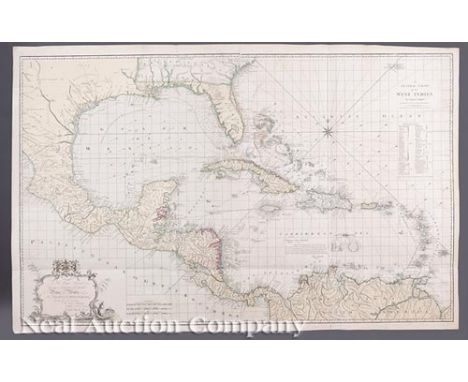
Captain Joseph Smith Speer (English, d. 1837) , "A General Chart of the West Indies By Captain J. S. Speer with Additions from the latest Navigators", London, Robert Wilkinson, 1796, with dedication "To His Royal Highness...Prince of Wales", hand-colored engraved map, 28 1/2 in. x 46 1/2 in., Ref: Phillips Maps, p. 1057; Servies, 494 (not listing this issue) Note: Captain Speer served in the Royal Navy, serving over 20 years on the Mosquito Coast. With his deep knowledge of the West Indies he produced many maps of the area, his most notable publication being The West-India Pilot in 1766.
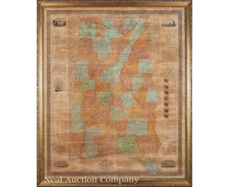
Lot 300
Monumental Map of Alabama and West Florida by John La Tourrette (American, b. 1785) , "An Accurate Map of the State of Alabama and West Florida: Carefully compiled from the original surveys of the General Government; designed to exhibit at one view each Section and Fractional Section, so that each person can point to the tract on which he lives; By John La Tourrette, Mobile, Ala.", Engraved by S. Stiles & Co, New York, 1837, hand-colored wall map, first state, with vignettes of The State House, A Cotton Plant, University of the State of Alabama, The U.S. Arsenal and Fort Morgan; inset maps of Mobile, Florence, Tuscaloosa, Tuscumbia, Huntsville, Montgomery, Wetumpka and Pensacola; and numerous economic and demographic charts, sheet 66 in. x 54 in., framed, original rollers unmounted but provided. Note: Little is known biographically about John La Tourrette, except that he was a cartographer who produced the most detailed, ornamental, and factual maps of the Southeast United States during the antebellum period. Born on Staten Island, New York in 1785, he moved to Mobile prior to 1830, as he is shown on that census as a 45 year old male. His first documented works were maps of the Creek Territory in Alabama and the Choctaw Territory in Alabama, both published in 1833. His next work of record is the subject Alabama and West Florida map in 1837. There are only four located copies of this map, one of which is the second state at the Alabama Department of Archives, containing the text “Printed by Colton & Co.” above the lower right border. The national Archives (Special List 29: Alabama #5) lists an 1837 La Tourrette Alabama map, there is no mention of Colton as publisher, so this could be another first edition/first state map as well, The 1850 Catalog of the Maine State Library lists a copy with little information about the map; a search of the current library records finds no map. The subject map was deaccessioned by the Connecticut State Library in 2012; it is the only documented copy of the first state at present, pending review of the National Archives copy. The located copies contain bold red U.S. Land Office District numbering, with the districts outlined in red, indicating the land use orientation of the map. Monumental maps of Mississippi and Louisiana followed, along with reissues of all three publications. La Tourrette relocated to New Orleans before 1845 and continued his publishing efforts there. The Alabama map was reissued in 1838 and 1856 by D. H. Cram.

Lot 323
Darby, William , The Emigrant's Guide to the Western and Southwestern States and Territories..., New York, Kirk & Mercein, 1818, octavo; includes "A Map of the United States Including Louisiana (18 1/4 in. x 22 1/2 in.), and "Chart of Mobile, Perdido & Pensacola Bays". Ref.: Wagner-Camp, 14b; Sabin, 18527; Howes, D-41; Servies, 924
Lot 293
Joseph Frederick Wallet Des Barres (British, 1722-1824) , "The North East Shore of the Gulph of Mexico", London, c. 1780, monumental copper engraved map, from The Atlantic Neptune, showing the area from Mobile Bay, AL eastward to Apalachicola, FL, 28 in. x 81 in . Ref.: Phillips Atlases, 1198-1205; Servies, 506. Note: Used extensively by the Royal Navy during the American Revolution, the Atlantic Neptune was the finest large scale sea atlas of the U.S. and Canadian Atlantic coast line ever produced. The maps were produced over a six year period (1775-81), and are known for their accurate portrayal of various sounds, bays, bars, and harbors as well as navigational hazards. This chart show an area from Bon Secour Bay at the mouth of Mobile Bay in Alabama, eastward to Apalachicola in Florida. The inlets, with soundings at Panama City, Destin, Pensacola and Perdido Bay (near Gulf Shores, Alabama) are shown. At the time of the issue, the only real settled areas shown were Pensacola and a small village just to the north named “Campbell Town” which does not exist today. Ref.: Phillips Atlases, 1198 1205; Servies, 506.

Lot 330
John Mitchell, (British, 1711-1768) , Plate 4 (Louisiana/Texas Sheet) from the eight-sheet "A Map of the British and French Dominions in North America with the Roads, Distances, Limits and Extent of the Settlements", 1755, London: Jefferys & Faden, second state, hand-colored engraved map, 27 in. x 19 1/8 in. Ref.: Rumsey, 2842; Phillips Maps p. 573

Lot 296
John Senex, (British, 1678-1740) , "North America, Corrected from the Observations Communicated to the Royal Society at London, and the Royal Academy at Paris", London, 1710, hand-colored engraved two-sheet map, the elaborate cartouche with allegorical figures and animals , 37 1/2 in. x 25 1/4 in
Lot 342
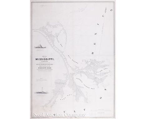
U. S. Government / Talcott, Andrew & Lee, T. J ., "Delta of the Mississippi Surveyed at the Suggestion of the Special Board of Engineers, Appointed to Devise a Plan for Improving the Entrance to the Mississippi River", Washington, 1840, lithographed map, with two vignettes showing the navigational hazards called mud lumps, 41 1/2 in. x 30 in. Ref.: Claussen & Friis, 358. Note: Andrew Talcott, U.S. Topographical Engineer, conducted the first detailed survey of the Mississippi River delta from February to July, 1838.The results of the survey were compiled and printed the following year. At the time, New Orleans was the fifth largest city in the United States and the dominant port on the Gulf of Mexico; the economy of the city was entirely tied to river commerce. Steamboat traffic had grown dramatically from its inception in 1812 to the 1830s, so getting material to New Orleans from the entire upper Mississippi basin took a fraction of the time it had previously. The problem of continuous navigation by seagoing vessels through the passes of the Mississippi into the Gulf had not been adequately addressed. The impetus for the Talcott survey in 1838 was to determine a way to increase water depths over the river mouth bars to allow year-round unfettered river/Gulf boat traffic; the first step was an accurate survey. Several interesting landmarks are noted on the chart. “South Light” appears on the sand split at the mouth of South Pass. Completed in 1832, the light existed only until 1839, when the structure was torn from its foundation by logs swept downriver. At Northeast Pass, the “North East Light” is shown near a “Salt Spring”. This lighthouse is more commonly known as the Frank’s Island light and was put into service in March 1823 when Northeast Pass was preferred over the others by mariners. Initially contemplated by architect Benjamin Latrobe as a classical stone structure, the initial lighthouse failed prior to completion due to the heavy mass built on deltaic mud. The second lighthouse was used until completion of the light at a nearby Pass a Loutre until 1856. The structure sank vertically into the mud some 20 feet before it was destroyed by a hurricane in 2002. Also shown nearby is the location of the historic Spanish and French Balize on Balize Bayou, noted as “Old Spanish Magazine”. The chart covers the area from the Gulf to Fort St. Phillip (1810) and Ft. Jackson (1832) across the river on the north. The uncommon Talcott chart, long overlooked as a critical document in the quest to improve navigation in the lower Mississippi, was not issued in all the government reports. The chart is an outstanding example of the lean, but decorative style of engraving and printing of the early Topographical Engineer surveys. Vignettes of Carr’s Lump and The Wart are beautiful renderings of mudlumps, which were both navigational aids and dangers.

Lot 331
John Melish (Scottish/American, 1771-1822) , "Map of the Seat of War among the Creek Indians From the Original Drawings in the War Department", Philadelphia, John Melish, 1814, engraved map, hand-colored in outline, with folds, as issued, from A Military and Topographical Atlas of the United States, 16 1/2 in. x 19 1/8 in., framed
Lot 316
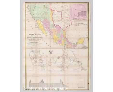
Samuel Augustus Mitchell (American, 1792-1868) , "Map of Mexico, Including Yucatan & Upper California, exhibiting the Chief Cities and Towns, the Principal Travelling Routes &c.", Philadelphia, 1847, third issue, hand-colored lithograph pocket map, with inset map of "Battle Field of Monterey"; "Map of the Principal Roads..." and "Profile of the Road between Mexico and Vera Cruz", 32 1/4 in. x 23 3/4 in. Ref.: Rumsey, 4594. Note: This pocket map was produced by Mitchell to satisfy the public’s interest in the Mexican American War, which resulted from the United States’ annexation of the newly independent Texas in 1845, territory which Mexico claimed as its own. This third issue is larger and more up-to-date than either predecessor, including the additional map showing the principal roads accessing Mexico City from Vera Cruz and a road profile. This information was vital for the final U.S. assault on Mexico City, which had not yet occurred at time of publication. Mexico City fell in October and led to the Treaty of Guadalupe Hidalgo in February 1848, which ended the question of US/Texas sovereignty in the region. Additionally, Mexican control from California to New Mexico was lost as well, paving the way for additional westward expansion by the U.S. Ref.: Rumsey, 4594.
![[Map of Mississippi Delta and Florida] , "Carte Generale de la Floride et du Delta du Mississippi", 1834, by Guillaume Poussi](https://cdn.globalauctionplatform.com/efdfc895-8340-4703-b9bf-a7050154ce0f/768826db-0fd7-47e3-fea6-6998f62fcbbc/468x382.jpg)
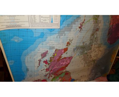
Lot 329
[Map of Mississippi Delta and Florida] , "Carte Generale de la Floride et du Delta du Mississippi", 1834, by Guillaume Poussin, hand-colored engraved map from the atlas Travaux d'amelioration en Amerique, with inset maps of St. Augustine and the entrances to the St. Mary and St. John rivers, 18 1/4 in. x 25 3/4 in

Lot 328
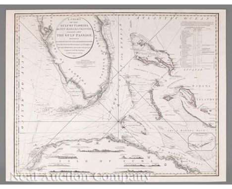
Thomas Jefferys, (British, 1719-1771) , "The Coast of West Florida and Louisiana/ The Peninsula and Gulf of Florida or Channel of Bahamas with the Bahama Islands", London, printed for Robert Sayer, 1775, engraved 2-sheet map in outline color, from Jefferys' West India Atlas , first state, 18 1/2 in. x 48 1/2 in., framed
![[New Orleans Map of Sixth District] , William H. Williams (American, 1817-1886), "Map of the Sixth District and Carrollton C](https://cdn.globalauctionplatform.com/efdfc895-8340-4703-b9bf-a7050154ce0f/1171a07b-8f5c-4769-fc06-15531f33de15/468x382.jpg)
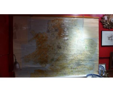
Lot 337
[New Orleans Map of Sixth District] , William H. Williams (American, 1817-1886), "Map of the Sixth District and Carrollton Compiled from Actual Surveys and the Best Authorities by Wm. H. Williams", 1871, lithograph by L. Manouvrier & D. Simon, with keys noting various structures, old names vs. new names and explanations of divisions, 30 in. x 23 3/4 in., framed. Provenance: Estates of Milburn and Nancy Calhoun, owners of Pelican Publishing Company, New Orleans, LA


Lot 327
Nicolas de Fer (French, 1646-1720) , "Les Costes aux Environs de la Riviere Misisipi. Decouvertes par Mr. de la Salle en 1683 et reconnues par Mr le Chevallier d'Iberville en 1698 et 1699...", Paris, 1705, hand-colored engraved map from L'Atlas Curieux, with detailed nomenclature of Indian tribes, the cartouche depicting the assassination of La Salle, 8 1/2 in. x 13 in. Ref.: Servies, 238; Lowery, 251; Martin & Martin, pl. 13. Note: First published in 1701 and reissued in 1705 in De Fer’s Atlas Curieux, this map is the earliest and most detailed depiction of mapping by Spanish pilots Barroto and Bisente, produced in their quest to find La Salle’s 1784 settlement on the Texas coast. That 1686 mapping coupled with Iberville’s renderings in the Mississippi delta in 1699 allowed De Fer to produce this highly accurate map for its time. It is used for the cover illustration of the HNOC’s Charting Louisiana.


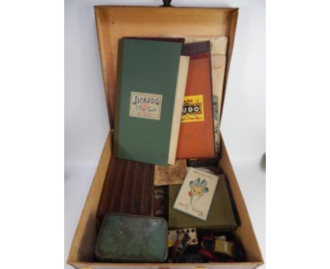


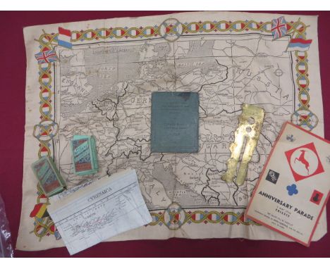
Lot 242
Small Selection of Various Items consisting RAF WW2 escape map “Cyrenaica” sheets K1 & K2. Coloured double sided silk ... Printed cotton WW1 period Europe map by Manchester Guardian ... 1946 Trieste Anniversary Parade ... Ox & Bucks LI Stand Easy Question book 1934 ... 1951 Air Ministry button stick.

Lot 297
Small Selection of WW2 Newspapers and Ephemera including The Prisoner of War Paper Sept 1943 ... POW written letter from Stammlager VIIIB ... Tripoli Times Jan 1943 ... The Crusader July 44 ... Daily Mail April 1941 ... Daily Herald Sept 1940 ... Daily Mail Aug 16 1940 ... German map for section of Norway ... Small selection of war revision maps of the UK.


Lot 304
Selection of Various Paperwork including City of London Services Rendered certificate. Framed ... Group photo post WW1 Royal Fusiliers and NCO’s. Some edge damage ... Print of HMS Birmingham ... Photograph HMS Caroline. East Indies 1922 ... Daily Mail map of Europe ... The Palestine Post for German surrender dated May 7 1945 ... Boer War silk embroidery handkerchief. Quantity.
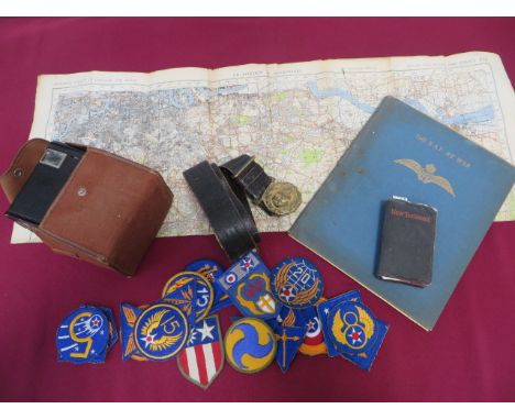
Lot 545
Small Selection of Various Items including POW Aid “New Testament”. Inside cover with pencil name “Frank Wells POW Hut 46 Room 10” and ink stamp “Stalag Luft 7” ... The RAF At War book printed 1941 ... 1940 paper map “SE London & Sevenoaks” printed 1941 ... Kodak Six-20 Brownie camera complete in its fabric case ... Post 1901 Royal Navy Officer’s black leather belt and gilt buckle ... 24 various embroidery USAAF badges.

Lot 553
Good Selection of Bombing Target Photos and Paperwork including paper damage plot map of Hamburg dated 2/3-8-43 ... Blank Bomb Aimer’s form ... Period made booklet covering night photos of fire tracks, searchlights, T.I. markers and bomb bursts ... Selection of bombing photos of various targets including Essen, St Lo, Kassel, Mailly Le Camp, Hannover and Dresden.
-
109182 item(s)/page