We found 109182 price guide item(s) matching your search

Refine your search

Year

Filter by Price Range
  • List
  • Grid
  • 109182 item(s)
    /page

Lot 134

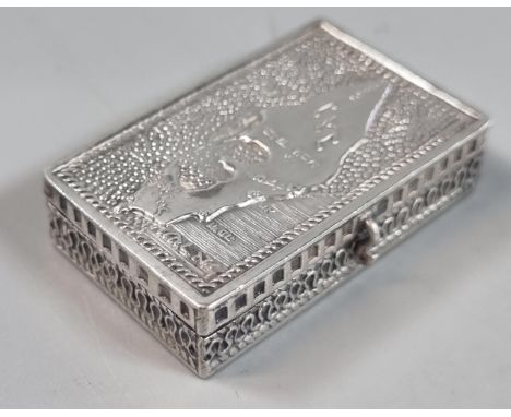
PLOWDEN, Francis: An Historical Review of The State of Ireland [5 vols.] Philadelphia (William Mc Laughlin, No 28 North Second Street & Bartholomew Graves No. 40 North Fourth Street) 1805, f/o map, contemporary calf, spines wornProvenance: Dawesfield House, Montgomery County, Pennsylvania, USALots 92 - 175 form part of the original contents of Dawesfield, Lewis Lane, Ambler, Montgomery County, Pennsylvania - an iconic American farmhouse built by Abraham Dawes and by descent through generations of the female line. It served as the Revolutionary Headquarters of General George Washington from 20th October until 2nd November, 1777.The books (lots 133 - 160) are from the personal library of Dr. Thomas Chalkey James (1766 - 1835) who was married to Hannah née Morris. Dr James was a Philadelphia physician and joined the staff of Pennsylvania hospital. In 1810 he was elected professor of midwifery at the University of Pennsylvania. He favoured being part of the intellectual and scientific life of Philadelphia, Dr James was a member of the American Philosophical Society, the librarian of the College of Physicians and a founder of the Historical Society of Pennsylvania. It is known that he preferred a quiet literary life at Dawesfield, which is witnessed by the categories of the books that were housed in the library.

Lot 178

A handcoloured map of Helstone, two handcoloured maps of field boundaries in the Helston area, a copy map of the River Fal, various Helston related Ordnance Survey Maps etc.

Lot 605

An 18th century hand-coloured map of Oxfordshire after Robert Morden

Lot 29

A 19th century black and white engraving of Porthleven Harbour with dedication and map for Messrs. Harvey & Co. of Hayle and Porthleven

Lot 643

A 17th century hand coloured map of Huntingdon by William Kip, framed and glazed

Lot 278

An 1831 hand coloured map of Helston showing the boundaries of the Old Borough after R. K. Dunstan, framed and glazed

Lot 537

A 17th century hand coloured map of Cornwall by Robert Morden, framed and glazed

Lot 604

An 18th century hand-coloured map of Monmouth after Robert Morden

Lot 3138

A dark patinated bronze fox mask door knocker, with brush and paws, 15cm; a Jugendstil style pewter tray, cast with a sailing ship, number 423, 22cm; an antiquarian style pipe bowl; a folding map of Paris, avec le parcours du Metropolitain; etc

Lot 461

Trade cards, Sunlight Soap, Sectional Map game, set 30 cards plus instruction booklet (cards gd/vg, booklet fair)

Lot 1165

Postcards, Switzerland, a mixed age collection of approx. 160 cards of Spiez Switzerland, with Gruss Aus for Hotel Schonegg, artists impressions of Spiez (5), mountain map cards, Niesenbahn, Niesen Kulm, hotels (Belvedere), costume, various views of Spiez and the lake (mainly gd)

Lot 1168

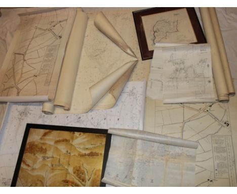
Postcards, Switzerland, a good Swiss mix of over 250 cards, with 13 map cards of towns (Luzern, Geneve), cantons, lakes etc. Also many maps of mountains, mountain passes, and lakes, 30 panoramic cards, Gruss Aus and Gruss Aus style (Rigi Bahn, Rigi First, Rigi Kulm), fantasy faces in the mountains (3 cards joined) (4), hotels, Venetian fete 27 July 1902 (fireworks), Easter greetings, good street scenes with markets (Vevey, Lausanne) (mainly gd)

Lot 865

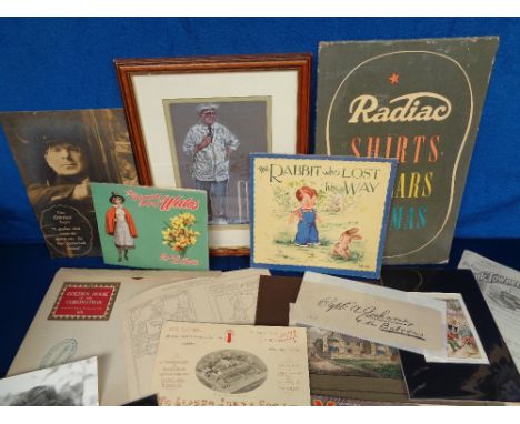
Ephemera, a selection of 100+ items to include advertising (Radiac Shirts, Collars Pyjamas and Raphael 'tractor standees), letter heads, magazine adverts including Coca Cola, 2 Louis Wain prints, Daily Mail Golden Book of the Coronation in presentation box, pop-up map of Wales, Deans book 'The Rabbit Who Lost His Way', signed print of Dickie Bird and much more (gen gd)

Lot 990

Ephemera, 12 items of Swiss ephemera, inc. Baedekers Switzerland 1877, 1881 and 1938 (3); 'A Guide to Zermatt and the Matterhorn' (1907); 'Swiss Federal Railway' tickets 1910 & 1921; pamphlet for 'Zermatt Gornergrat' 1927, and 1932 editions; pamphlet for 'Bernese Oberland' and Alps Railway; Tourist map of Switzerland 1928 and 1912; Ian Allan Mountain Rail Guide to Switzerland; 'Neue Karte der Schweiz' (map); maps of Bernese Oberland East and a map for the West. Also 11 hotel ads, Huntley & Palmers ad, cdv of Swiss soldier (mainly gd)

Lot 1163

Postcards, South East Asia, a selection of approx. 22 cards of Japan and Hong Kong, inc. Japanese steam sailing ship, IJTS 'Taisei Maru' Post Office San Pedro Cal. USA (map Japan to USA route), Yahiro Museum Nagasaki, Kyoto, Tea House Mogi Rd Tagami Nagasaki, Hong Kong Harbour, Chinese Fantan game etc (gd)

Lot 853

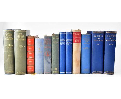
POLAR EXPLORATION; Ernest H. Shackleton 'The Heart of the Antarctic' published by William Heinemann 1909, first edition, being the story of the British Antarctic Expedition 1907-1909, in two volumes, blue cloth with silvered titles, Robert Falcon Scott, 'Scott's Last Expedition' in two volumes, being the journals of Captain RF Scott, London 1913, third edition, arranged by Leonard Huxley with preface by Sir Clements R Markham, with sketches, plates, panoramas, and maps, in two volumes, Gino Watkins 'JM Scott' published by Hodder & Stoughton 1935, second edition, Robert F Scott 'The Voyage of Discovery' published by John Murray, London 1929, Herbert G Ponting 'The Great White South' or 'With Scott in the Antarctic', published by Duckworth & Co, London 1923, Cherry Garrard Apsley 'The Worst Journey in the World Antarctic 1910-1913', one volume edition, published by Chatto and Windus, London 1952, Ernest Shackleton 'South, The Story Of Shackleton's Last Expedition 1914-1917', published by William Heinemann, London 1982, F Spencer Chapman 'Northern Lights: The Official Account of The British Arctic Air Route Expedition 1930-1931' published Chatto & Windus, 1934, fourth edition, with map and plates, and Fridtjof Nansen 'Farthest North, Being the Record of the Voyage of Exploration of the Ship Fram 1893-96', published by George Newness, London 1898, in two volumes, a fifteen-month slow journey by Dr Nansen and Lieutenant Johansen with an appendix by Otto Sverdrup Captain of the Fram, with plates and maps (12).

Lot 285

Israeli 925 silver snuff box with map to the hinged cover and marked 'I M Fan' to the back. 0.5 troy oz approx. 4cm wide approx. (B.P. 21% + VAT)

Lot 391

Two boxes of toys to include: Waddington's Jig Map, Airfix and similar model kits, diecast model vehicles, the Corgi Collection Dakota airplane etc. (2) (B.P. 21% + VAT)

Lot 127

Robert Morden, original map of Suffolk and another similar, Norfolk, together with Christopher Saxton, original map of Suffolcle (sic).(Suffolk). Framed and glazed. (2) (B.P. 21% + VAT)

Lot 391

A box of assorted collectables including a treen bottle holder, a carved wood casket, war time ephemera, an antique map of Durham, chess set, draughtman's instruments, three headed page turner etc.

Lot 786

Various pictures and prints including etchings, colour lithographs, 19th century hand coloured map, etc.

Lot 804

A 19th century hand coloured map of lancashire by E Baines 1824, framed and glazed, 55.5cm x 67cm.

Lot 959

Three mirrors together with a framed map

Lot 593

After Robert Morden (English, 1650-1703). A map of Kent, hand coloured engraving, 35cm x 65cm.

Lot 331

An 18thC map of Leicestershire, showing coats of arms Simon de Montefort and others, hand coloured engraving, 39.5cm x 51cm.

Lot 327

An 18thC map of Rutlandshire, hand coloured engraving, beneath details of the road from London to Norwich, plate number 115, 19cm x 12cm, together with a new map of Herefordshire, drawn from the latest authorities, hand coloured engraving, 20cm x 15.5cm. (2)

Lot 333

An 18thC map of Herefordshire, showing coats of arms, hand coloured engraving, 40cm x 48cm. (AF)

Lot 329

John Speed (1552-1629). A map of Barkshire with a view of Windsor, hand coloured engraving, 40cm x 52cm.

Lot 595

A Greenwood and Company map of the county of Lincoln, from an actual survey made in the years 1827 and 1828, coloured engraving by Josiah Neele, published by Greenwood and Company, London, 1831, 63cm x 74cm.

Lot 597

A Greenwood and Company map of the county of Derby, from an actual survey made in the years 1824 and 1825, coloured engraving, with a vignette of Chatsworth, by J & C Walker, published by Greenwood and Company, London, 1830, 59cm x 70cm.

Lot 479

After Willem Kip (17thC). Cumbria map, black and white engraving 28cm x 32cm.

Lot 426

An oak framed old map of Ireland, 76 x 72cm overall, some wear, see images

Lot 137

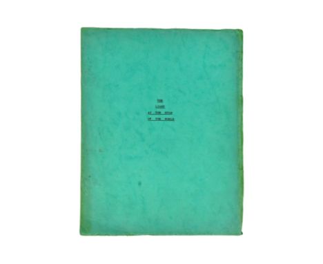
From the collection of Vickers Staniforth - 'The Light At The Edge Of The World' (1971 movie starring Kirk Douglas) - an original screenplay / production script for the film. Written by Beverley Cross and dated December 1965. Ameran Films Ltd, London. 133pp with printed map and card covers.  The Light at the Edge of the World is a 1971 Spanish-American adventure film, directed by Kevin Billington and starring Kirk Douglas, Yul Brynner, Samantha Eggar, and Fernando Rey. It was adapted from Jules Verne's classic 1905 adventure novel The Lighthouse at the End of the World. The plot involves piracy in the South Atlantic during the mid-19th century, with a theme of survival in extreme circumstances, and events centring on an isolated lighthouse.

Lot 595

ROYAL WELCH FUSILIERS EPHEMERA & BOER WAR GROUP OF SIX, to Pte. Robert Langford Williams (Royal Welch Fusilers) no. 5891, Queen's South Africa Medal with Orange Free State, Transvaal, Relief of Ladysmith, Tugela Heights and Cape Colony clasps, King's South Africa Medal with South Africa 1901 & 1902 clasps, 1914 Star with clasp and RWF badge, War Medal, Victory Medal with RWF badge and GV Long Service & Good Conduct Medal, all in glazed wood case/frame; together with Lce. Corpl. Robert Williams Character Certificate dated 1920, Royal Welch Fusiliers photograph album containing 27 photographs of soldiers in uniform and in sporting clubs, 1911 map of the Coronation Durba in Delhi, 91 x 75cms (grp)Provenance: consigned from north WalesComments: medals good, album covers worn with loss to spine binding, map discoloured along the creases with tears, inspection advised.

Lot 134

Trip Around The World, Stereoscope Cards, American, c.1900, printed by Underwood & Underwood, faux book box containing explanatory booklet titled 'A Trip Around The World By Means of the Stereoscope' with details on the 72 accompanying stereocards along with a fold out map.

Lot 15

John Norden and John Speed - 'Sussex Described and Divided' (Map of the County), engraving with later hand-colouring, probably 17th Century, 15.25" x 20" (39 x 51cm).

Lot 20

Robert Morden, a map of Kent, etching later hand coloured, 13.75" x 25" (35 x 63.5cm), along with an antique map of the area around Westerham, etching, plate size 19" x 26.5" (48 x 67cm), (2).

Lot 92

John Speed, a 17th Century map of 'The Countie Pallatine of Lancaster', hand coloured, 16" x 21" (41 x 53cm), along with a map of Cheshire published by Thomas Kitchin, 18th Century, 7.25" x 8.75" (18.5 x 22cm), (2).

Lot 201

19th Century a portrait of a naval captain holding a map, watercolour probably over a photographic base, 11" x 8" (28 x 20cm) oval, John Moffat, Edinburgh label verso.

Lot 94

After Thomas Yeakell, 'The Environs of Brighthelmstone', engraved map, circa 1800, 17" x 20" (43 x 51cm).

Lot 93

Robert Morden, a map of Kent, Circa 1700, hand coloured, 14.5" x 25.5" (37 x 65cm), along with 'Tunbridge Wells humbly Dedicated to Thomas Pellet M.D.', a hand coloured etching, early 18th Century, 14" x 17.5" (36 x 44.5cm), (2).

Lot 71

An antique map showing the 'British Islands in the West Indies' engraved by J. & C. Walker, 13" x 15.75" (33 x 40cm).

Lot 95

Map of the County of Sussex. From an actual Survey made in the years 1823 & 1824.by GREENWOOD, C.& J, hand coloured engraving, Circa 1830, 23" x 27.5" (58 x 70cm).

Lot 1002

Philip Morant - The History and Antiquities of the County of Essex, compiled from the best and most ancient Historians, Chelmsford Reprinted And Sold By Meggy And Chalk 1816, 2 vols, quarter calf, with folding map to volume 1

Lot 1016

Rare map of local interest showing Port of Ipswich, plan of the Wet Dock and part of the River Orwell with proposed Improvements by George Harwood, engineer, March 6th 1843, hand coloured lithograph by J Basire, 46 x 72cm, glazed frame

Lot 1017

Johannes Blaeu: 17th century hand tinted engraved map of Suffolk, with German text verso, 38 x 49cm, glazed frame

Lot 1018

Johannes Blaeu: 17th century hand tinted engraved map of Essex, plate 43 x 52cm, glazed frame

Lot 1019

John Speede, 17th century map of Essex - devided into Hundreds, with the most ancient and fayre Towne Colchester Described and other Memorable Monuments observed, 1662, sold by Thomas Bassett & Richard Chiswell (1676), 39 x 52cmm glazed frame

Lot 1023

J Blaeu, hand coloured map of Norfolk, c1650. 38cm x 50cm, framed and glazed.

Lot 1087

17th century hand coloured engraved map of Suffolk by Janssonius, 38cm x 49cm, in glazed frame

Lot 1088

Mid 18th century hand coloured engraved map by Emanuel Bowen, 'Suffolk Divided into its Hundreds', 52cm x 70cm, in glazed frame

Lot 831

John Speed - 17th century engraved map - The Kingdom of China, sold by Baskett and Chiswell, English text verso, plate 40 x 51cmLoss to margins top left and lower left corners, grubby marks, otherwise condition is mostly original, no holes, no tears

Lot 832

John Speed - 17th century engraved map of Asia, sold by Baskett and Chiswell, with English text verso, plate 40 x 51cm

Lot 834

John Speed - 17th century engraved map of Tartary, sold by Baskett and Chiswell, English text verso, plate 39 x 50cm

Lot 835

John Speed - 17th century engraved map of Europ and the chiefe Cities contayned therin ..., pen inscriptions to the margins, English text verso, plate 39 x 50cm

Lot 836

John Speed 17th century engraved map of Bermuda, sold by Baskett and Chiswell, plate 40 x 53cm, English text versoSignificant staining in various areas, a large split from top centre fold, creases, minor tears to bottom edge

Lot 837

John Speed 17th century engraved map of Africa, engraved by Abraham Goos, English text verso, plate 40 x 52cm

Lot 838

John Speed 17th century engraved map of The Romane Empire, English text verso, plate 41 x 50cm

Lot 839

John Speed 17th century engraved map of Greece, sold by Baskett and Chiswell, English text verso, plate 41 x 50cm

Lot 840

John Speed 17th century engraved map of The British Isles, English text verso, plate 41 x 50cm

Loading...Loading...
  • 109182 item(s)
    /page

Recently Viewed Lots