We found 109182 price guide item(s) matching your search
There are 109182 lots that match your search criteria. Subscribe now to get instant access to the full price guide service.
Click here to subscribe- List
- Grid
-
109182 item(s)/page


Lot 116
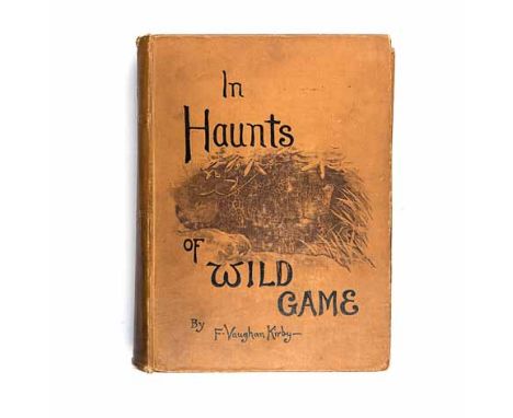
Kirby, Frederick Vaughan HAUNTS OF WILD GAME: A HUNTER - NATURALIST'S WANDERINGS FROM KAHHAMBA TO LIBOMBO London: William Blackwood & Sons, 1896 First edition. B/w illustrations in profusion. Pictorial cloth, spine age darkened, wear to extreme edges of spine. Map lacking from this very sought after book. Bookplate of Abel Chapman. A little wear to corners.


Lot 1213
THEATER-MADE P-38 DESK ORNAMENTFine Pacific Theater-made desk ornament, approx. 11 1/2" x 7" x 6 1/2", a representation of a Lockheed P-38 fighter, supported by a curved piece of clear Plexiglas over a metal plaque depicting a map of New Guinea, inscribed "Far Eastern Air Force, New Guinea 1943-44". The map is further inscribed with notable settlements on the island, each marked by a small dot of inlaid green glass. The whole is mounted on an oval wood base. The P-38 appears to be lacking its propellers, else very good.
Lot 1252
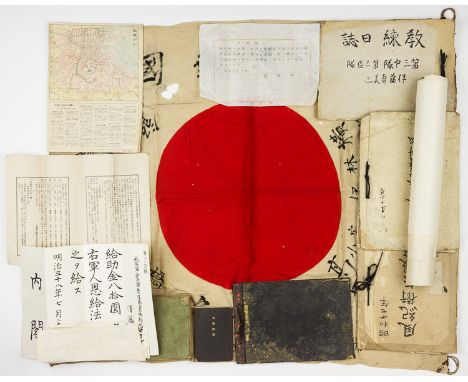
JAPANESE SAILOR'S "GOOD LUCK" FLAG AND DOCUMENTS GROUPING A rare grouping of items from a Japanese petty officer, first class who served in the IJN during World War I. Included in the lot is: the sailor's "good luck" body flag, a 28" x 32" national flag with two leather tabs with tie cords at either end of the hoist, the flag embellished with many slogans and exhortations painted in black ink; approx. twenty documents, some holograph, some printed, including award documents for the Tsingtao Medal (1915) and Siberia Expedition Medal (1921), pay documents, several promotions, notes on signals, etc. Also present is a printed map-newspaper, three notebooks or workbooks with holograph maps and printed regulations, hand-drawn insignia, and two bound handbooks, both covering cavalry and the care of horses. Untranslated, should be seen.
Lot 259
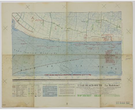
UTAH BEACH SOUTH - INVASION MAP OF LANDING CRAFT AND BEACH DEFENSESHighly important and historical map intended for use in the D-Day invasion of France in Normandy. The map, titled "UTAH BEACH-SOUTH (La Madeleine)" shows perhaps two miles of the beach with its known and suspected defenses overprinted in red. The 25" x 20" map is further marked "TOP SECRET - BIGOT UNTIL DEPARTURE FOR COMBAT OPERATIONS THEN THIS SHEET BECOMES RESTRICTED" and "FIRST BEACH OBSTACLE OVERPRINT - Information as of 12 May [1944]" All types of underwater obstacles are shown, including ramps, hedgehogs, and tetrahedrons, and shore defenses include mine fields and gun emplacements. There is also a notice to the Nazy coxswain who would be piloting and inbound craft. The bottom of the map shows a matching panoramic photo of the beachfront, and the verso has beach elevations and tidal charts. The map is from the estate of Brice W. Rhyne of the 8th Regiment who landed at UTAH, sold with a transcript of his May, 1945 recollection of the landing and aftermath. Soiling and wear consistent with use. An excellent relic.
Lot 260
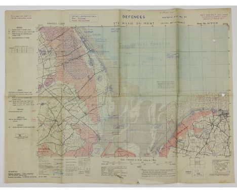
MAP OF THE DEFENSES OF UTAH BEACH, FROM A COMBAT VETERAN WHO LANDED THEREA most important map showing the German defenses of the four landing zones comprising UTAH BEACH, northwest of St. Marie du Mont and just east of St.Martin de Varreville. The 27 1/2" x 20 3/4" map is titled: "DEFENCES STE. MARIE DU MONT Information as at May 44". Additional printed notes include: "TOP SECRET until issued for briefing ground troops; thereafter SECRET" and "This map will NOT be carried in operational aircraft" No credit is given the map's creators, but it is certainly American and most likely the 660th U.S. Engineers. The map has light topographical and structural details, with a blue printed overlay of all of the artillery and machine gun defenses, redoubts, pillboxes, blockhouses, and fields of fire in the region, along with suspected but unconfirmed defenses. The landing zone shows a suspected minefield on the beach, limited machine gun coverage, and flooded fields. Other areas heavily involved in the opening hours of the battle are also shown, including la Houssaye and St. Martin de Varreville, just east of Ste. Mere Eglise. The verso of the map bears an exhaustive key to every symbol used on the map. The map is from the estate of Brice W. Rhyne of the 8th Regiment who landed at UTAH, sold with a transcript of his May, 1945 recollection of the landing and aftermath.
Lot 262
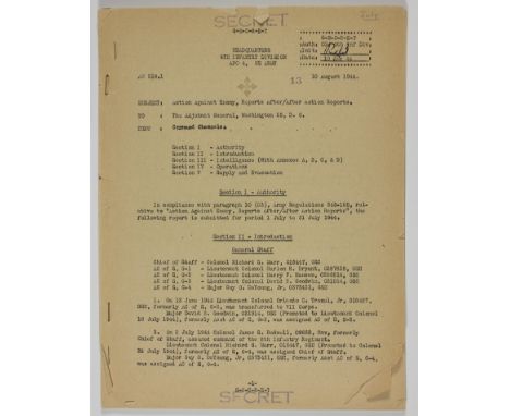
D-DAY AFTER-ACTION REPORT, 4TH INFANTRY DIVISIONFine content after-action report of the 4th Infantry Division following its landing at Utah Beach on D-Day, a mimeographed document 40pp. 4to., "Headquarters 4th Infantry Division", August 10, 1944 and marked "SECRET" throughout. The 4th Infantry Division assaulted the northern coast of German-held France during the Normandy landings, landing at Utah Beach, June 6, 1944. The report, which covers the period from June 2nd to July 31st, opens with a list of the officers commanding the division and then sets forth the division's day-by-day actions starting on D-Day. The report states that resistance was heavy every day until about June 14th, and states that no prisoners were taken (!). The division encounters SS Panzer divisions, Panzer Grenadier divisions, the 14th Fallschirmjager Div., etc. which all retreat in a haphazard manner. Operations are also set forth, showing the movements of various elements per map coordinates and overlays, units relieved and those placed in action, etc. The report also shows supply and evacuations statistics, German and American orders of battle, intelligence findings including the arrests of subversives, photo intelligence, and so on. First page has a few marginal chips, one page has a clean tear, else very good. From a veteran of the 8th Infantry Reg., 4th Division. The 4th's soldiers were first to land on Normandy, and relieved the isolated 82nd Airborne Division at Sainte-Mère-Église. It then proceeded to clear the Cotentin peninsula and take part in the capture of Cherbourg on 25 June. After taking part in the fighting near Periers, 6–12 July, the division broke through the left flank of the German 7th Army, helped stem the German drive toward Avranches, and by the end of August had moved to Paris and gave French forces the first place in the liberation of their capital.
Lot 263
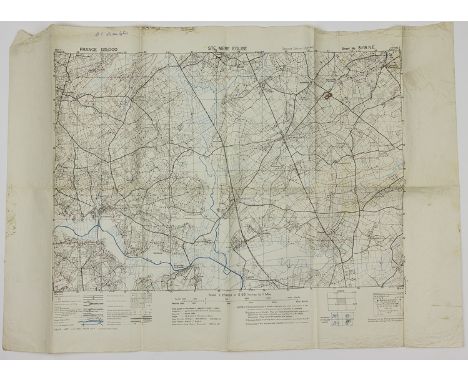
AMERICAN ENGINEERS' MAP OF STE. MERE EGLISE, APRIL, 1944Important military map of the Norman countryside including Ste. Mere Eglise where the 505th P.I.R. or the 82nd Airborne found themselves in dire straits early on the morning of D-Day. The map, 30 1/2" x 21", is titled "STE. MERE EGLISE" and shows the strategic town near the center. Elevation, as well as other topographical details, structures, fields, forests, rivers, etc. are clearly indicated. This is a very late map, possibly the last one prior to D-Day: it is headed "SECOND EDITION (APR. 1944)". The map was prepared by the 660th U.S. Engineers who were responsible for much of the cartography of the region for invasion purposes. The map is from the estate of Brice W. Rhyne of the 8th Regiment who landed at UTAH, sold with a transcript of his May, 1945 recollection of the landing and aftermath. The 8th relieved the 82nd Airborne at Ste. Mere Eglise. Very good.
Lot 264
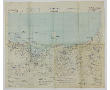
"INVASION MAP" OF CHERBOURG, FRANCEAn outstanding map prepared for a potention invasion of France at Cherbourg, or perhaps made to deceive the Germans as part of OPERATION FORTITUDE, a 25" x 21" map titled "DEFENCES CHERBOURG Information as at May 44". The map is further marked: "TOP SECRET until issued for briefing ground troops; thereafter SECRET" and "This map will NOT be carried in operational aircraft" The map was created by Co. B, 660th U.S. Engineers. It has light topographical and structural details, with a blue printed overlay of all of the artillery defenses, redoubts, pillboxes, blockhouses, and fields of fire in and around Cherbourg, including the offshore islands. The harbor was heavily fortified with chains barring entry and fortifications and barriers lining the coast. The verso of the map bears an exhaustive key to every symbol used on the map. The map is from the estate of Brice W. Rhyne of the 8th Regiment who landed at UTAH, sold with a transcript of his May, 1945 recollection of the landing and aftermath. A rare item, in very good condition.
Lot 266
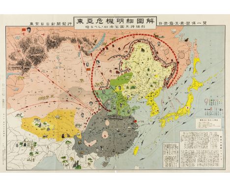
"ILLUSTRATED ANALYSIS OF EASTERN ASIA CRISIS" WITH EARLY PUBLISHED PHOTO OF MAOAn excessivley rare situation map published in Chinese: "Illustrated Analysis of Eastern Asia Crisis", 30 1/2" x 21", 1936, issued by the Tokyo Daily News Publishing House, Oct. 10, 1936, printed by Tokyo Factory of Jingbang Printing Co., Oct. 5, 1936. This map, issued only seven months before the Japanese invasion of mainland China, shows the various regions of the country then embroiled in civil war: territory in pink is held by the communists, with Mao shown in a small photo portrait, gray lands held by Nationalists with Chiang Kai Shek shown, green areas are held by Zhi's group of warlords, and so on. Battle fronts, sea and supply routes, and troop movements are also indicated, with the entirety overlooked by Josef Stalin who can be seen at upper-left. A striking historic map, with only a few tiny holes along vertical fold apparent. From a single collection obtained entirely in China pre-2000.
Lot 272
ARCHIVE OF AN AMERICAN M.P. GUARDING GERMAN P.O.W.S IN TEXASLarge grouping of material from the service of Army T/Sgt. Normand L. LaRoche, 370th M.P.E.G. (Military Police Escort Guard) who spent most of his military service guarding German prisoners being held at various P.O.W. camps in Texas. A vast collection of material is included in this comprehensive collection. Included is: two wool "M P" arm bands; a group of about 200 reports and records from Camp Fannin, Texas, Sep. 29-Dec. 20, 1944, including some camp regulations, a list of "protected personnel", multiple lists of German prisoners attached to work details, medical notations, prisoner transfers, etc.; a revised memorandum of rules and regulations, 54pp. 4to., Dallas, Nov. 6, 1944; approx. 150pp. of reports from the POW camp at Milam and Camp Fannin, Tx., late 1944, a variety of data including lists of prisoners and work production, largely amounts of wood cut; type of work done, breakdown of non-coms and regular soldiers working, etc.; approx. 40pp. of lists naming prisoners present, on work details, or transferred to camps at Milam, Huntsville, St.Augustine, Claiborne, and Fort Crockett; and much more. In August, 1945 LaRoche was sent to Bayeux, France to deal with American occupation troops. His first notebook written there bears several pages on dealing with French prostitutes. Also included is his lengthy travel diary commencing December, 1945. Publications in this grouping include LaRoche's copies of: Basic Field Manual, Interior Guard Duty; 1941 War Department Infantry Drill Regulations; Sep. 16, 1943 Infantry Regs. Field Manual; Thompson Submachine Gun guide, Dec. 31, 1941; MPs promotional booklet; Scouting and Patrolling Manual; two M1 and BAR score books (unused); 1940 Red Cross First Aid Text-Book; Red Cross Instructions Outline, First Aid Courses; 1917 Catholic Prayer Book for the Army and Navy; "My Military Missal; "Army Talks" magazine, Nov. 18, 1945 on German propaganda; July 1, 1944 Texas road map, and a murder mystery inscribed: "Read this in Berlin standing on Adolph's face". Also included are three scrapbooks with about 70 photos of LaRoche and ruins in Brussels and Berlin, but largely filled with travel souvenirs, with multiple personal notes on prisoners and other subjects, his wallet with a few passes, clippings, etc. Camp Fannin was an enormous facility which trained over 200,000 G.I.s in less than thtree years, while also containg German P.O.W.s. Only two escaped, and they were quickly recaptured. A most interesting grouping!
Lot 274
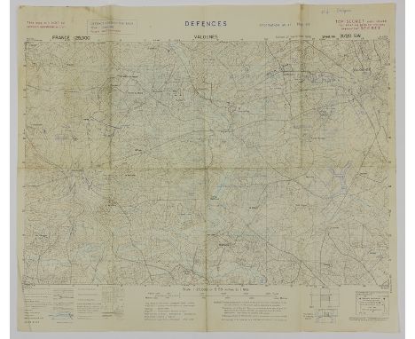
AMERICAN INVASION MAP OF VALOGNESImportant battle map intended for use in the capture of the strategic town of Valognes shortly after D-Day. The map is titled: "DEFENCES VALOGNES" and is further marked in red: "TOP SECRET until issued for briefing ground troops; thereafter SECRET" and "This map will NOT be carried in operational aircraft" No credit is given the map's creators, but it is certainly American and most likely the 660th U.S. Engineers. The map has light topographical and structural details, with a blue printed overlay of all of the artillery and machine gun defenses, redoubts, pillboxes, blockhouses, and fields of fire in the region, along with suspected but unconfirmed defenses. Valogne appears near the upper-right corner with les Penques appearing in the opposite, lower corner. The map measures 24" x 21" and includes a detailed key on the verso. Folds, else very good. Valognes was decimated by Allied bombs on D-Day and several days thereafter. On June 20th, elements of the 8th Infantry Regiment, en route to Cherbourg, made their way through the ruins of the town which would later serve as a communications hub. The map is from the estate of Brice W. Rhyne of the 8th Regiment who landed at UTAH, sold with a transcript of his May, 1945 recollection of the landing and aftermath.
Lot 281
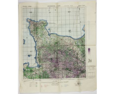
BRITISH WAR OFFICE MAP OF CHERBOURG AND CAEND-Day related map "Cherbourg & Caen", 30" x 35", a topographical and road map showing the Cherbourg to Le Havre in the east, south to Evran and east again to Alencon. The map mainly concerns itself with altitudes, and its scale of colors shows heights from zero to 400 meters. The map was originally prepared in 1914 - this 4th edition was issued by the British War Office in 1943. Folds, very good. The map is from the estate of Brice W. Rhyne of the 8th Regiment who landed at UTAH, sold with a transcript of his May, 1945 recollection of the landing and aftermath. The 8th also participated in the liberation of Cherbourg.

Lot 292
JAPANESE SOLDIER'S GROUPING A lot of items taken from an unknown Japanese soldier, includes a small photo of the soldier in uniform standing before a destroyed armored vehicle; 12 pieces of paper Japanese currency; a carefully-wrapped temple charm carried by the soldier, a 34" x 26" cloth Japanese national flag, new condition; a Japanese Red Cross medal; 18" x 15" topographic map of an unknown coastline, soiled and probably field-used; a 23" x 16" topographic map, unknown inland area; a brown imprinted documents bag with draw string; a 300pp. 12mo. bound guide for an artillery observer or perhaps for use by officers placing forces in the field, two additional bound guides, one heavily used and annotated; and a printed text contained within a green cloth cover, possibly religious content. Worth researching.

Lot 305
SS PANZERGREANDIER'S HOLOGRAPH STUDY MANUALPair of study books used by an SS Panzsrgrenadier in his studies before joining his regiment, the soldier's name illegible but the books dated 1944. Each book is about 20pp. 8vo.and written in a very clear and distinct hand, with several illustrations. One booklet concerns a grenade launcher including uses, parts, operation, aiming, distance measuremnent, etc., the second book concerns itself with various topics including map reading, tank attack, coordination with artillery, gas mask use, MG-42 parts and operation, hand grenade use, machine pistols, distance measurement, and so on. File folder cover chipped, booklets and contents are fine.
Lot 307
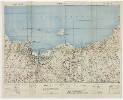
U.S. ARMY 1943 TOPOGRAPHICAL MAP OF CHERBOURGScarce D-Day related map "Cherbourg", a 24" x 19 1/4" topographical map showing the crucial port contained within "Lambert Zone I (Red)", prepared by the U.S. Army 62nd Engineers and dated "Edition of July 1943". Buildings, rivers, swamps, woods, etc. all all marked. Of course, this map would have been consulted in the planning for D-Day, mainly in the diversionay actions taken to convince the Germans that Cherbourg would be the scene of the principal landings. Near fine. The map is from the estate of Brice W. Rhyne of the 8th Regiment who landed at UTAH, sold with a transcript of his May, 1945 recollection of the landing and aftermath. The 8th also participated in the liberation of Cherbourg.

Lot 330
"OLYMPIA 1936" CIGARETTE BOOKSScarce publication, a pair of "cigarette" photo books, "Olympia 1936", Volumes I and II, (Hamburg: Cigaretten Bilderdienst), 1936, 168pp. and 126pp., each 9" x 12 1/4", in blue cloth with black lettering and gilt Olympic logo. These books were originally devoid of photos but were filled with images by smokers who accumulated high-quality photos as they purchased cigarettes. Both volumes are complete, and incredibly Jesse Owens and other racial "inferiors" are fairly represented (though caricatured at the bottom of the page). Hitler is given the first page - a full-page illustration - and German athletes are most prominently depicted. Volume I also includes a fold-out map of the Olympic village. Both volumes retain their original dust jackets. Some slight wear to the edges of the jackets, else very good.
Lot 355
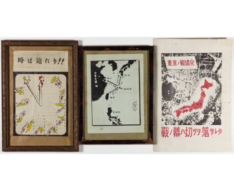
AMERICAN ANTI-JAPANESE PROPAGANDA LEAFLETSGood group of three air-dropped leaflets, aimed at demoralizing the citizens of mainland Japan at the end of World War II. The first, 5" x 7 1/2", is entitled "Time is Pressing!" It depicts twelve Pacific islands, including Guadalcanal, Attu, the Marshalls, the Admiralty islands, New Guinea, and Tarawa, arranged in the shape of a clock face, with Japan at the twelve o'clock position. All but Japan are marked with broken Japanese flagpoles, signifying defeats on those islands, and the hands of the clock rest on the Philippines at the eleven o'clock position, signifying that Japan's time is nearly up. The second leaflet, 5" x 7", is a simple map of the Pacific Ocean, depicting the distances between the recently captured island of Okinawa and important Japanese bases on Formosa (now Taiwan), China, and mainland Japan, demonstrating the ease with which American forces can attack each of these targets. The final leaflet, 7" x 10", is simply titled "Tokyo Becomes a Battlefield", and depicts a map of Japan superimposed over an aerial photograph of Tokyo, indicative of the view enjoyed by American bomber pilots. The verso bears a message entitled "American Air Force Fiercely Bombs Tokyo", and goes on to describe the frequent bombing raids launched against Tokyo by large groups of planes, with an admonition to surrender. The first two leaflets described are mounted in simple wood frames, and all bear folds, else very good.
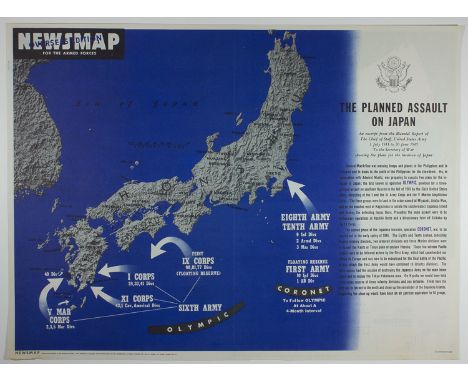
Lot 357
AMERICAN PACIFIC WAR EDUCATIONAL POSTERSPair of double-sided educational posters, the first 16 3/4" x 22 1/4", and the second 23 1/4" x 17 1/4", both entitled "Newsmap for the Armed Forces: Overseas Edition". The larger of the two, published March 19, 1945 by the Army Information Branch, Army Service Forces, addresses the Battle of Iwo Jima, and feature b/w photos of the invasion force making its way towards the beach, Marines disembarking from various landing craft under enemy fire, Marines dug into the volcanic sands, and stretcher bearers removing the wounded from the field, as well as a small inset photo depicting the famous flag raising at Mt. Suribachi. The verso of this poster bears two maps, one depicting current American offensives in the Pacific, and the other addressing the American capture of Cologne, Germany. The smaller poster, published Oct. 22, 1945, features a map of the planned invasion of mainland Japan, specifically Operations "Olympic", an invasion of Kyushu, and the subsequent Operation "Coronet", an assault on Tokyo and Yokohama. Of course, neither of these assaults, slated for the fall of 1945, were ever carried out, as Japan surrendered on August 15, following the atomic attacks against Hiroshima and Nagasaki. The verso of this poster features a graphic demonstrating the populations of Asia, the Americas, and Europe and Africa at that time. Both posters bear their original folds, with very slight scattered chipping at the edges, else very good.

Lot 367
BELGIAN UNDERGROUND NEWSPAPER COLLECTION, PART IIICollection of Belgian underground newspapers printed and distributed during the German military occupation of that country. These papers, part of a large collection offered in this sale, were issued by the many partisan, royalist, nationalist and communist organizations all resisting the cruel Nazi rule of Belgium. Not researched, but some of these issues are undoubtedly extremely rare. Included in this group is: "Liberation", printed newspaper, 8pp. no. 19, Aug. 1944; "Le Combattant", mimeo. news sheet and printed newspaper, Dec. 6, 1942, Jan. 7, 1943, Sep.11, 1943; "La Belgique Nouvelle", printed newspaper, 4pp. , Mar. 15, 1943; "Le Mouvement Syndical", printed news sheet, 10pp. , undated and march, 1944; "Le Peuple", printed socialist newspaper, 4pp. , June, 1942, Aug. and Nov. 1943, Feb. 1944; "PAX Revue", printed news sheet, 8-10pp., nos. 8 and 10; "La Voix du Cheminot", printed newspaper, 6pp., no. 7, Jan. 1943; "Solidarite", June and July, 1944 (nos. 1 and 2), each 4pp.mimeo. news sheet, EXTREMELY RARE AND IN CYRILLIC, issued to Russian prisoners held in Belgium, with French translations and hand-drawn map used in the news letter; also "Solidarite" in newspaper form, 4pp., Jan. 1944; "L'Agent des Services Publics", 6pp. mimeo. news sheet, no. 8, Aug. 1943; and about 30 immediately post-liberation and post-war Belgian newspapers. Overall very good.

Lot 525
"THE ETERNAL JEW"Color postcard, 4" x 6", promoting the anti-Semitic exhibition "The Eternal Jew", depicts an orthodox Jew with gold coins in one hand, a whip in the other, with a map of Poland with Soviet hammer and sickle. This commemorative postcard, sold to visitors, is canceled in Vienna, Aug. 15, 1938. Fine.

Lot 544
GERMAN ANTI-SEMITIC AND ANTI MASONIC LITERATUREGood group of eight pre- and post-World War II anti-Semitic and anti-Masonic publications in German, includes: "Vernichtung der Freimaurei Durch Enthullung ihrer Geheimniffe " ("Destruction of Freemasonry by Uncovering their Mysteries"), by Erich Ludendorff (Munich: Ludendroffs Verlagn GmbH.), 1940, 116pp. 8vo., written by the prominent World War I general who became a nationalist leader and took part in the Kapp Putsch and Munich Beer Hall Putsch; "Zur Volkskunde der Juden" ("On the Folklore of the Jews"), by Richard Andree (Bielefeld: Verlag von Velhagen & Klasing), 1881, 296pp. 8vo., includes a fold-out color map of the Jewish population of central Europe; "Die Wiedergeburt, das innere wahrhaftige Leben" ("The Rebirth, The Inner True Life"), by "Einem Freimaurer" (Wurttemberg: Druck und Verlag von Karl Rohm), 1908, 172pp. 8vo., front cover detached but present; "Die entdeckten Henker und Brandstifter der Welt und ihr 2000 jahriges Berschworungssnistem" ("The Discovered Executioners and Arsonists of the World and their 2000-Year Spellbinders"), by Jens Jurgens (Munich: Verlag Fortschittliche Buchhandlung), 1928, 111pp. 8vo., featuring derogatory caricatures of several Jewish figures, including Lenin and several allegedly Jewish popes; "Vortrag un Fuhrer durch die Freimaurerloge in Erlangen" ("Lecture and Guide by the Freemason's Lodge in Erlangen"), (Erlangen: Karl Muller), [n.d.], 20pp. 8vo.; "Geheime Weltmachte"("Secret World Power"), by S. Fpares (Munich: Ludendorffs Verlag GmbH.), 1936, 47pp. 8vo.; "Verschworung" ("Conspiracy"), by Juan Maler (Buenos Aires: Juan Maler), 1980, 320pp. 8vo., by SS officer Reinhard Kopps, who fled to Bariloche in Argentina following World War II and lived under the assumed name Juan Maler; and "Der Sieg der Vernunft" ("The Victory of Reason"), by Juan Maler (Buenos Aires: Juan Maler), 1978, 539pp. 8vo. Each volume is softbound, and each bears some wear and bumping to the covers and spine, with some ink notations, else very good.

Lot 49
GENTLEMAN'S MAGAZINE AND HISTORICAL CHRONICLE VOLUME XLVI FOR THE YEAR 1776 INCLUDING MENTION OF "LATE VOYAGES OF THE RESOLUTION AND ADVENTURE" AND A PART MAP OF THE TROPICAL DISCOVERIES OF CAPTAIN J. COOK IN 1774, LONDON, QUARTER CALF TOGETHER WITH SEVEN CALF BINDINGS OF THE ANNUAL REGISTER(PAGES MISSING) 1771, 1776, 1781, 1788, 1789, 1790 AND 1794 [8]

Lot 260
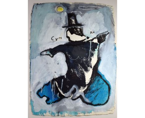
IWAN BALA mixed media on paper - political statement on the Welsh Nation and entitled 'Hon' with an outline map of the Nation and an accompanying letter in Welsh explaining his motivation for the work; Wales was in the 18th and 19th Century depicted as an old woman and that in this version the artist has tried to 'put some life back into her step' and that 'Hon' (her) moves energetically like a dancer. 'Hon' also refers to the poem by T H Parry Williams 'God help me I cannot escape from Her (Wales) and in the same way I cannot escape from trying to change the image of 'Her', signed, 77 x 58cms


Lot 323
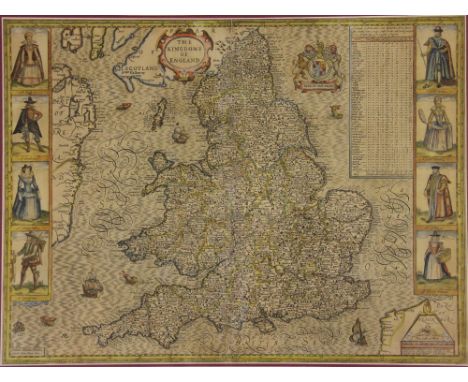
ROBERTSON (J), THE ELEMENTS OF NAVIGATION..., and a compendium for finding latitude and longitude at sea, to which is added a treatise for marine fortification, vol II only, 6th edition, folding map frontis, other folding maps and tables, 48pp of transverse tables, worn full calf, London, 1796 (1)
Lot 347
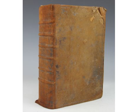
BREECHES BIBLE - EARLY 17TH CENTURY: lacking title to Old Testament, begins with the first book of Moses (repaired), many small engraved details and maps, engraved title to 'the second part of the bible', engraved title to the New Testament, with 'diligent reader' reader page and map verso, last two pages of the second table, full suede calf, London, Robert Barker, 1902 (at fault)
Lot 351
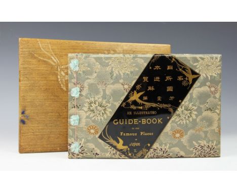
SHIZUKI (TAKAHISA), AN ILLUSTRATED GUIDE BOOK TO THE FAMOUS PLACES OF JAPAN, vol 1, complete with forty-four hand coloured wood block illustrations, comprising 29 full page plates, 8 folding plates, 3 folding plans with key, a folding map, a full page map and frontis piece, gilt pictorial end papers, in original silk work binding with gilt lacquered panel to front board, Tokio, Meikosha, Ginza Sanchome, 1892, in original bamboo two section box decorated with cranes and flowers, Meiji, Japanese, Fuji


Lot 361
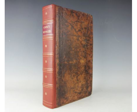
ANDERSON (G), A NEW AUTHENTIC AND COMPLETE COLLECTION OF VOYAGES ROUND THE WORLD...containing an authentic, entertaining, full and complete history of Captain Cook's First, Second, Third and Last Voyages, with 147 engraved plates and maps only (lacking frontis and large folding map)., re-backed full calf, London, Alex Hogg, 1784 (1) (at fault)


-
109182 item(s)/page