We found 109182 price guide item(s) matching your search
There are 109182 lots that match your search criteria. Subscribe now to get instant access to the full price guide service.
Click here to subscribe- List
- Grid
-
109182 item(s)/page


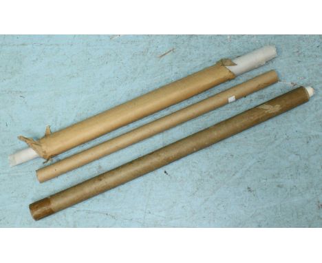
Lot 532
After Thomas Milton, a hand-coloured printed map: 'A Geographical Plan and West Elevation of His Majesty's Dock Yard Near Portsmouth, with part of The Common,' including a panoramic view of the harbour with numerous fully-rigged ships, above a plan of the harbour, framed within scrollwork and vignettes, 48x68cm, mounted, glazed and framed


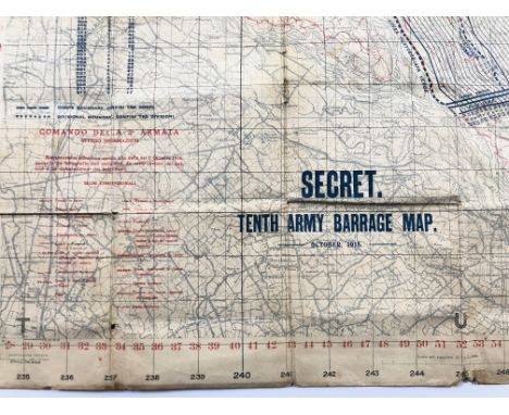
Lot 595
WW1 October 1918 French 10th Army creeping Barrage Trench Map.A rare example, printed in French and English, marked “Secret Tenth Army Barrage Map October 1918”. The map is printed with lines indicating the positions and timings for the creeping barrage. The map has been worn with service and some age wear.
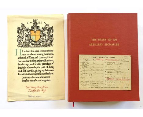
Lot 600
WW1 Personal Diary of Herbert Frederick John Mann MM Royal Field Artillery.This detailed unpublished 200 page typed diary records the front life experiences and thoughts of Gunner of the Royal Field Artillery during 1918. He describes being gassed at Drocourt, finding a crashed British aircraft, with burned bodies, the action resulting in the award of the Military Medal etc. The typed diary was compiled in 1922 and is complimented by original documents, fold out maps, including a landscape sketch map of the British front line found in a German dug out. Other items include aerial propaganda leaflets etc. Accompanied by original Soldier’s Paybook. ... Also Memorial Scroll for his brother Sergeant George Henry Mann of the South Staffordshire Regiment. The overall condition is good the diary has been professionally rebound in red cloth with gilt tooling.Gunner Herbert Frederick John Mann MM was born at Chesterton Cambridge in 1887, after leaving school at 12 he worked at the Fitzwilliam Museum and later at the Addenbrooke’s Hospital as Chief Clerk and accountant. It was in this capacity he found himself at the start of the Great War. Volunteering his services to the army due to his occupation he was not called to the Colours until October 1917. His embarkation was delayed further and it would not be until April 1918 he set foot in France. The final 100 days saw his Battery in heavy action, at Drocourt he describes being gassed “watching the gas filling the valley”. Surviving this he was once again gassed at Bleharies. He comments that on more than one occasion it was not the German bombs falling on the British trenches but those of the new RAF. He also describes seeing the burnt bodies of pilot and observer next to their crashed aircraft and the more mundane daily activate of sleeping, fleas and rats. The diary records the 2nd September 1918 “our troubles began all day shells were falling closer and closer” the telephone line was cut under heavy fire and he went out to find the break and repair it. Returning to his dug out he was informed the wire was cut again. Out he went again under shell fire and German aircraft bombs, on one occasion a shell falling just 20 yards from him. His dugout received a hit and collapsed. In total he was to venture out on five occasions to repair the line, he was informed the following day his name had been put forward for the award of the Military Medal. In October news was received that his brother George serving with the 2nd Bn South Staffordshire Regiment had died of wounds. On the 11th November he was in a rest camp Numugees when he got the news of the Armistice. Proceeding to Cologne he served with the army of occupation until his discharge in October 1919. He returned to his former job at Addenbrooke Hospital until his retirement in 1948, he died in 1976.

Lot 22
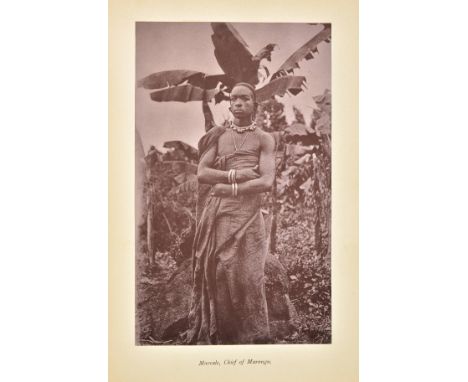
Meyer (Hans). Across East African Glaciers. An Account of the First Ascent of Kilimanjaro, translated from the German by E. H. S. Calder, 1st edition, George Philip & Son, 1891, mounted chromolithographic frontispiece, 20 plates including photogravures from watercolours and mounted photographic prints, 3 folding colour maps, half-title and first folding map browned, short closed tear to inner fold of last folding map, marginal browning to a few photogravure plates (images unaffacted), bookplate of Charles Granston Richards to front free endpaper verso (see note), inner hinges skilfully consolidated, top edge gilt, others untrimmed, original pictorial cloth, spine and tips slightly rubbed, a couple of faint abrasions to front board, large 8vo Neate M93 'First undisputed ascent of Kibo Peak; handsome volume'. Provenance: Charles Granston Richards (1908-1996), missionary and publisher in Kenya and East Africa. (1)
Lot 24
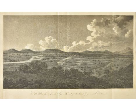
Morritt (John Bacon Sawrey). A Vindication of Homer and of the Ancient Poets and Historians, who have recorded the Siege and Fall of Troy. In Answer to Two Late Publications of Mr. Bryant, 1st edition, York, 1798, folding map, five folding aquatint plates after Gaetano Mercati, some toning and waterstains, offsetting and occasional light spotting, some pencil annotations and marginalia, original boards, manuscript title to spine, some wear to spine, upper cover detaching, some edge wear and stains, 4to Abbey Travel 398; Atabey 840; Blackmer 1157. Provenance: James Rennell (1742-1830, British geographer and 'Father of Oceanography'), his pencil annotations and bookplate, with the additional bookplate of his daughter Lady Rodd (1785?-1863), revisor and publisher of her father's works. "Morritt wrote this account of his sojourn in the Troad in response to Bryant's Dissertation concerning the War of Troy, 1796 and to his attack on Le Chevalier in Observations upon a Treatise, entitled a Description of the Plain of Troy, 1796... This journey to the Troad was made in November 1794, in company with James Dallaway and the artist Gaetano Mercati, who was in the service of the English ambassador Sir Robert Liston." (Blackmer). (1)
Lot 25
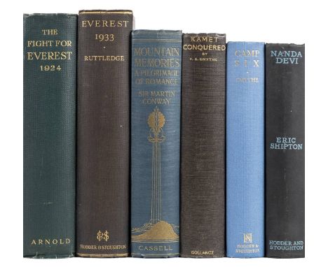
Norton (Edward Felix). The Fight for Everest: 1924, 1st edition, Edward Arnold & Co., 1925, 32 colour and half-tone plates including frontispiece, folding photographic panorama, folding colour plate, toning to plates, fore and bottom edges untrimmed, original green cloth lettered in gilt, front board slightly marked on top edge, large 8vo, together with: Ruttledge (Hugh), Everest 1933, 1st edition, Hodder & Stoughton Limited, 1934, 59 sepia-tinted plates from photographs, 4 maps (of which 3 folding), light spotting to text-leaves facing maps and to edges, original cloth, large 8vo; Shipton (Eric), Nanda Devi, 1st edition, Hodder & Stoughton, 1936, photographic plates with captioned tissue-guards, light toning, spotting and browning to endpapers, original cloth, spine slightly rolled, 8vo; Smythe (Francis Sydney), Camp Six. An Account of the 1933 Mount Everest Expedition, 1st edition, Hodder and Stoughton Limited, 1937, photographic plates, spotting to adjacent leaves, original blue cloth, a bright copy, 8vo; ibid., Kamet Conquered, 1st edition, Victor Gollancz Ltd, 1932, photographic plates, folding colour map, text-block toned, original black cloth, slightly rubbed, 8vo; and 14 others, all Himalayan mountaineering (including a reprint of John Hunt's The Ascent of Everest, signed by Edmund Hillary), original cloth, 8vo Neate N31 (Norton), R99 (Ruttledge), S63 (Shipton), S114 (Smythe), S118 (Smythe). (19)
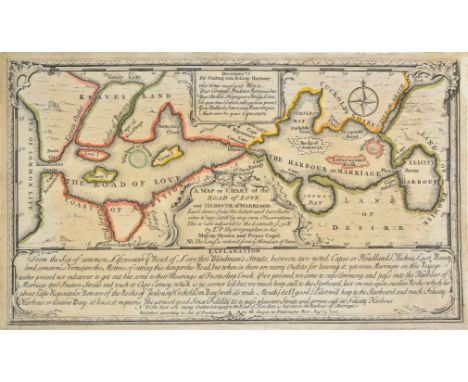
Lot 250
Allegorical map. Cooper (Mary), A map or chart of the road of love and harbour of marriage..., Aug. 15th 1747, engraved map with contemporary outline colouring, old folds, long repaired closed tears, 175 x 300 mm, together with an 18th century pen and ink manuscript copy of the above map, old folds, some splitting along old folds, laid on later paper, 200 x 296 mm A scarce allegorical map showing the journey of love, beginning in the 'Sea of common life' and ending in 'Felicity harbour' having passed through the 'Harbour of marriage'. (2)

Lot 251
Asia. Munster (Sebastian), Asia wie es Jetziger Zeit nach den Furnemesten Herrschafften Abgetheilet und Beschriben ist, Basel, [1588 or later], uncoloured woodblock map, trimmed at base but without loss to map, slight marginal dust and finger soiling, 315 x 365 mm, printer's woodblock device and German text to verso (1)
![British Isles. Waldseemller (Martin), Principium Europae..., [title on verso], Strasbourg, [1525], uncoloured Ptolemaic map o](https://cdn.globalauctionplatform.com/bdcc24b5-51e4-450c-9a38-a98300b3d03e/1ac3ece1-e9ba-4f61-aaaa-a985012d0350/468x382.jpg)
Lot 254
British Isles. Waldseemller (Martin), Principium Europae..., [title on verso], Strasbourg, [1525], uncoloured Ptolemaic map of the British Isles on a trapezoidal projection, 295 x 410 mm, Latin text with elaborate renaissance woodcut panels [believed to have been designed by Albrecht Durer] on verso R. W. Shirley. Early Printed Maps of the British Isles 1477 - 1650, 17. (1)

Lot 255
British Isles. Bacon (Cecil W.), What do they talk about?, published Taylowe Ltd, Slough, for 'The Geographical Magazine' and the marketeers of Esso, [1951], pictorial colour lithographic map, old folds, 670 x 445 mm, together with The Radio Times (publisher), Coronation number, June 1953, fifty pages with numerous illustrations including Bacon's double page 'Coronation Route map' as the centrefold, publisher's yellow printed paper wrappers (2)
Lot 258
British Isles. Moll (Herman), A new map of Great Britain according to the newest and most exact observations, published Thos. & John Bowles, John King, [1732], large engraved map with contemporary hand colouring on two sheets conjoined, inset map of the Shetland Islands, picture frame cartouche and compass rose, old folds strengthened on verso, lower vertical margin trimmed tp plate mark, occasional marginal closed tears, 1025 x 625 mm R.W.Shirley, Printed Maps of the British Isles, 1650 - 1750, Moll 7. state 3. (1)
Lot 259
British Isles. Valk (Gerard), Les Isles Britanniques, qui contiennent les Royaumes d'Angleterre Ecosse, et Irlande..., Tire de G. Cambdene, Chr. Saxton, I. Speede, T. Pont, R. Gordon, et de I. B. Boazius, published Amsterdam, [1694], engraved map with contemporary hand colouring, inset map of the Shetland and Faroe Islands, large allegorical cartouche and mileage scale, 485 x 585 mm, together with De Wit (Frederick), Nova Totius Angliae, Scotiae et Hiberniae..., circa 1680, engraved map with contemporary outline colouring, 480 x 565 mm Both maps in good condition. (2)
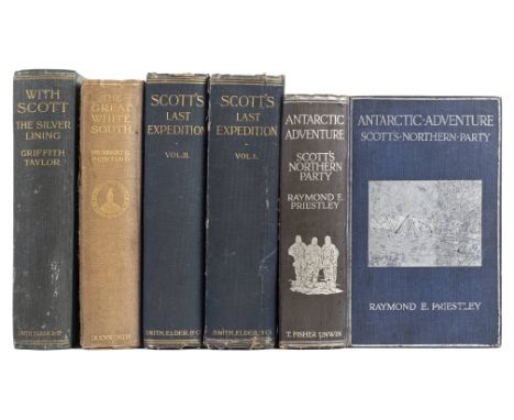
Lot 26
Priestley (Raymond E.). Antarctic Adventure, Scott's Northern Party, 1st edition, T. Fisher Unwin, 1914, 98 photographic plates, 3 folding maps, spotting to text block, ownership inscription to front pastedown, original blue cloth lettered and decorated in silver, spine slightly faded, spotted and and rolled, extremities slightly rubbed with light wear to spine-ends and tips, 8vo, together with: Ponting (Herbert G.), The Great White South, being an Account of Experiences with Captain Scott's South Pole Expedition and of the Nature Life of the Antarctic, 1st edition, Duckworth & Co., 1921, 96 photographic plates, 1 map in text, spotting to outer leaves, margins and edges, free endpapers browned, contemporary gift inscription to front free endpaper, original cloth, spine sunned and rolled, cloth split along rear joint, a few pale marks to side, wear to tips, 8vo; Taylor (Griffith), With Scott: The Silver Lining, 1st edition, 1st state, Smith, Elder & Co., 1916, numerous photographic plates, 2 folding maps, line-drawings and sketch-maps in the text, modern cloth with original spine and covers laid down, rubbed, 8vo; Scott (Robert Falcon), Scott's Last Expedition, 2 volumes, 1st edition, Smith, Elder & Co., gravure frontispieces, numerous plates mainly from photographs, 2 folding panoramas, 8 folding maps, spotting, top edges gilt, others untrimmed, original cloth, fraying to spine-ends, wear to tips and to volume 1 rear joint, 8vo Taylor's work is in first state, without the additional preface leaf which was added later. (5)

Lot 261
Crimea & the Black Sea. Homann (Johann Baptist), Tabula geographica qua pars Russiae Magnae Pontus Euxinus seu Mare Nigrum et Tauriae Regnum cum sinitimis Bulgariae, Romaniae et Natoliae provinciis exhibetur, Nuremberg, circa 1730, engraved map with bright contemporary hand colouring, one marginal closed tear, 585 x 490 mm, together with Seutter (Matthaus), Nova et accurata Tartariae Europae seu Minoris et in specie Crimeae delineatio geographica cum omnibus circa Pontum Euxinum et Paludem Maeotidem jacentibus provinciis manu et sumtibus, Augsburg, circa 1740, engraved map with contemporary outline colouring, 500 x 580 mm (2)
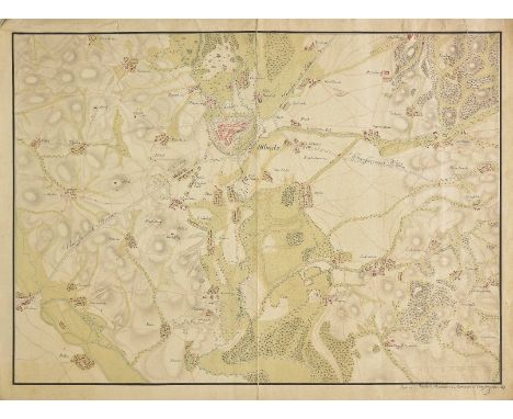
Lot 262
Czechoslavakia. Koderl (Josunn?), Manuscript map of the country surrounding the town of Olomouc, 1820, large watercolour and pencil map, some dust soiling largely confined to the margins, some marginal fraying and closed tears, 475 x 645 mm, together with another manuscript map of the same region by another hand (Nathias Berchel), toned overall, some marginal fraying, 470 x 640 mm The maps are highly detailed showing contours, roads, rivers, forests, settlements and fortifications. It is probable that these were executed by soldiers or military cadets as the maps have a martial appearance. The first map has the legend 'Bombardier & Baumann Compagnie' at the base. (2)
Lot 263
*Derbyshire. Speed (John), Anno Darbieshire described, John Sudbury & George Humble [1627], engraved map with early hand colouring, inset town plan of Derby, lower right corner missing and replaced in facsimile, central fold strengthened on verso, slight browning to central fold, 385 x 515 mm, framed and double glazed, English text on verso (1)
![*Drayton (Michael). Two allegorical maps, [1612 or later], hand coloured engraved maps, one showing Shropshire west of the Ri](https://cdn.globalauctionplatform.com/bdcc24b5-51e4-450c-9a38-a98300b3d03e/101355d7-d50e-441d-8448-a985012d0a36/468x382.jpg)
Lot 268
*Drayton (Michael). Two allegorical maps, [1612 or later], hand coloured engraved maps, one showing Shropshire west of the River Severn, the other showing Herford, Worcester and Gloucestershire centered on the Malvern Hills, the map of Hereford, Worcester and Gloucestershire with slight worming, each approximately 250 x 335 mm, mounted, framed and glazed (2)
![*Drayton (Michael). Hereford, Worcestershire & Gloucestershire, untitled allegorical map, [1612 or later], hand coloured](https://cdn.globalauctionplatform.com/bdcc24b5-51e4-450c-9a38-a98300b3d03e/ba09539c-6fdf-4876-a22d-a985012d0b1a/468x382.jpg)
Lot 27
Roosevelt (Theodore). African Game Trails, an Account of the African Wanderings of an American Hunter-Naturalist, 1st trade edition, New York: Charles Scribner's Sons, 1910, photogravure frontispiece, map, 48 photogravure or half-tone plates, contemporary gift inscription to front free endpaper, top edge gilt, others untrimmed, original tan pictorial cloth gilt, recased, a few marks, tips bumped and worn, 8vo, together with: Hunting Trips of a Ranchman, Sketches of Sport on the Northern Cattle Plains, 1st UK edition, Kegan Paul, Trench & Co., 1886, full-page wood-engravings, spotting to half-title, one gathering (pp. 97-112) proud but holding, contemporary bookplate and ownership inscription of Somerville Reid Livingstone-Learmonth (1861-1934), original maroon cloth, slightly marked, spine sunned, tips bumped and worn, 8vo; Outdoor Pastimes of an American Hunter, 1st UK edition, Longmans, Green & Co., 1905, photographic plates, occasional finger-soiling to text-block, Brighton College bookplate, discreet blind stamp to title page, original green pictorial cloth gilt, recased, cloth mottled, 8vo; Through the Brazilian Wilderness, 1st UK edition, John Murray, 1914, photogravure frontispiece (spotted), half-tone plates, folding map, endpapers renewed, original cloth, spine faded, covers mottled, 8vo; and 3 others on American game hunting Czech, Africa pp. 138-9 for African Game Trails; Howes R-430 for Hunting Trips of a Ranchman. (7)
Lot 270
East Anglia. Blaeu (Johannes), Regiones Inundatae in sinibus comitatus Norfolciae, Suffolciae, Cantabrigiae, Huntingtoniae, Northamtoniae et Lincolniae, Amsterdam, circa 1662, engraved map with contemporary hand colouring, slight spotting largely confined to margins, 435 x 545 mm, Spanish text on verso, mounted, together with Greenwood (C & J), Map of the county of Cambridge from an actual survey made in the years 1832 & 1833, published 1834, engraved map with contemporary hand colouring, an edition without the central fold, 575 x 720 mm, with another thirty maps of Cambridgeshire, Norfolk and Suffolk, including examples by Morden, Darton, Archer, Hall, Seller/Grose, Cary, Lewis, Cole & Roper, Philips, Harrison, Dawson, Ellis, Laurie and Fullarton, occasional duplicates, various sizes and condition (32)
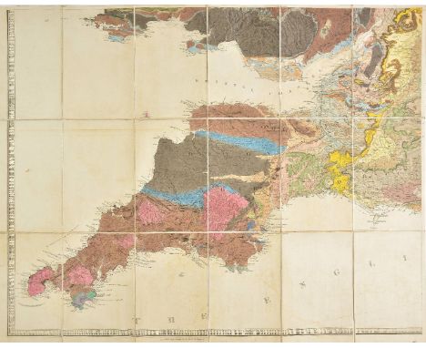
Lot 272
England & Wales. Greenough (George Bellas), A Geological Map of England & Wales by G. B. Greenough Esq. F.R.S., President of the Geological Society, published by the Geological Society, 2nd edition, November 1st. 1839, engraved map with contemporary hand colouring, sectionalised and laid on linen on six sheets, calligraphic title with a manuscript number '137' below title, separate 'index of colours', each map sheet approximately 635 x 810 mm, slight offsetting, contained in a contemporary green morocco gilt book box with 'envelope style' lid, slight wear to extremities A bright example of a map which was controversial at the time of its publication, in that Greenough was accused of plagiarising William Smith's earlier and ground breaking geological survey and map of 1815. Greenough was stung enough by the critisicm to issue a written defense of his actions which was published in 'Memoir of a Geological Map of England: to Which are Added, an Alphabetical Index to the Hills, and a List of the Hills Arranged According to Counties (1820)'.William Smith's low social staus and background resulted in his work being largely ignored and the Geological Society of London did indeed plagiarise the map, undercutting Smith's asking price, which eventually pushed Smith to financial ruin and the debtor's prison. Recognition of his role as 'The Father of English Geology' would only follow much later in 1831 when Smith was awarded the Woolaston medal by the Geological Society. Greenough's map is important in its own right and is now recognised as a separate piece of scholarship but unlike Smith it involved no surveying but relied on other surveyors sending him information which he then collated. (1)
Lot 273
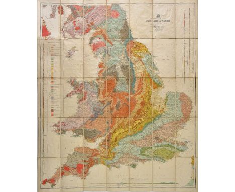
England & Wales. Geikie (Sir Archibald), Geological Map of England & Wales reduced chiefly from the Ordnance and Geological surveys..., published John Bartholomew, circa 1870, colour lithographic map, sectionalised and laid on linen, four horizon profiles and a table of explanation, some dust soiling, 1010 x 850 mm, bound in publisher's blue cloth boards with gilt title to upper siding (1)

Lot 275
England & Wales. De Wit (Frederick), Anglia Regnum in omnes suos ducatus, comitatus et provincias divisum, circa 1680, engraved map with contemporary outline colouring, 585 x 490 mm, together with Danckerts (Theodore), Novissima et accuratissima totius Angliae, Scotiae et Hiberniae tabula, Amsterdam, circa 1685, engraved map with contemporary outline colouring, some staining, offsetting and dust soiling, 500 x 580 mm, with Jaillot (Alexis-Hubert), Magnae Britanniae tabula comprehens Angliae, Scotiae ac Hiberniae Regna ad usum serenissimi Burgundiae ducis, 1696, engraved map with contemporary outline colouring, inset map of the Shetland and Faroe Islands, toned overall, slight staining, central fold partially strengthened on verso, 490 x 600 mm, plus Allard (Carel), Regni Angliae et Walliae principatus tabula..., [1689], hand coloured engraved map, some fraying and marginal closed tears, old folds, 505 x 590 mm, and Sanson (N. & Marriette P.), Les Isles Britanniques ou sont Le Royaume D'Angleterre..., Paris, 1665, hand coloured engraved map, inset map of the Shetland and Faroe islands, slight staining, 410 x 530 mm, with Sanson (N.), Britannicae Insula in quibus Albium sive Britannia Major Ivernia sive Britannia Minor..., published Amsterdam, J. Covens & C. Mortier, [1728], hand coloured engraved map, old folds, some offsetting, 415 x 525 mm (6)

Lot 276
Essex. Blaeu (Johannes), Essexia comitatus, Amsterdam, circa 1662, engraved map with contemporary hand colouring. some overall dust soiling and toning, some staining, 420 x 530 mm, Spanish text on verso, together with Jansson (Jan), Essexiae descriptio. The description of Essex, Amsterdam, circa 1636, uncoloured engraved map, in the pre-atlas state without the heraldic shields, 385 x 495 mm, no text on verso (2)

Lot 279
Europe. Anonymous, Jeu de la Guerre Europ‚enne, 1914 - 1915, French lithographic map game based on a map of Northern Europe, trimmed to image, old folds,510 x 680 mm, together with Pasch (Max), Wenn sie Sieften (booklet), 1917, containing a double page colour photolithographic map of Northern Europe, map size 375 x 520 mm, with Anonymous, L'Europe en 1915. La fin de la Prusse et le D‚membrement de l'Allemagne et l'Autriche-Hongrie, 1915, socio-political map of Northern Europe, 425 x 545 mm, plus Rand McNally (publishers), Summary of the Treaty of Peace, circa 1919, colour photolithographic map of Europe with an explanation of the Treaty above the map, old folds, 645 x 660 mm (4)
Lot 28
Sauvan (Jean-Baptiste-Balthazar). Picturesque Tour of the Seine, from Paris to the Sea: with Particulars Historical and Descriptive, 1st edition, later issue, R. Ackermann, 1821 [i.e. 1828 or after], 24 hand-coloured aquatint plates after A. Pugin and J. Gendall, hand-coloured engraved map, hand-coloured aquatint vignettes to title page and p. 177, dedication leaf, list of subscribers, text watermarked 'H S & S 1818', frontispiece watermarked 'J Whatman Turkey Mills 1828', Triel plate watermarked '1820 J Whatman Turkey Mills', other plates not watermarked, or watermarked Whatman with date obscured, mild offsetting, Havre plate soiled verso, but the plates exceptionally bright, all edges gilt, later 19th-century red half morocco gilt, 4to (34.6 x 27.4 cm) Abbey Travel 90, Tooley 445. (1)
Lot 280
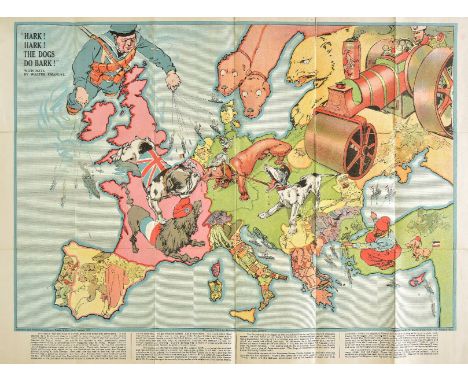
Europe. Bacon (G. W. & Co., publishers), Hark! Hark! The Dogs do Bark!, designed by Johnson, Riddle & Co., 1914, colour lithographic serio-comic allegorical map of Europe, old folds, some splits to old folds, repaired on verso, explanatory notes below map by Walter Emanuel, 535 x 710 mm, bound in publisher's printed paper wrappers A famous cartographic curiosity, published at the outbreak of the first world war, depicting some of the main protagonists as dogs, including the British bulldog, a dandified French poodle, German dachshund and Austrian mongrel. Russia is depicted as a steam-roller, with the Czar at the controls, and a British sailor controls the Royal Navy with a series of dog leads. The British Bulldog has a firm grip on the German Dachshund's nose. The Russian steam roller has crushed the Austrian mongrel's tail. (1)

Lot 283
France & Belgium. Lotter (Tobias Conrad), Mappa geographica in qua Ducatus Lotharingiae et Barr..., Augsburg, circa 1740, engraved map with contemporary hand colouring, 500 x 585 mm, together with Nouvelle carte de Cercle de Bourgogne on l'on voit toutes les possessions de la Maison d'Autriche dans les Pays Bas..., Augsburg, circa 1740, engraved map with contemporary hand colouring, 470 x 620 mm, together with Homann (Johann Baptist and heirs of), Comitatus Flandriae in omnes ejusdem subjacentes ditoes cum adjacentibus accuratissime divisus..., Tabula Ducatus Britanniae Gallis le Gouvernemt. general de Bretagne..., Charte von Lothringen und Barr..., [and] Gubernatio generalis Languedociae occitania olim dictae..., circa 1790, together four engraved maps with contemporary hand colouring, two maps with some overall toning, each approximately 485 x 585 mm (6)
Lot 288
Germany. Ortelius (Abraham), Silesiae typus descriptus et editus a Martino Heilwig..., [1579], engraved map of Silesia with contemporary hand colouring, 280 x 385 mm, Latin text on verso, together with Van Deventer(Jacob), Nitidissimae civitatis Mechlineensis in meditullio Brabantiae, [1615 or later], uncoloured engraved map, some creasing, 230 x 310 mm, with Braun (Georg & Hogenberg Franz), Hermannus Hammelman, Wesalia in Ducatu Cliuensi urbs clara opibus dignitate aedificiis et mercatura quam navigio in flumine Rheno exercet, circa 1580, hand coloured engraved town plan, slight soiling to margins 345 x 480 mm, German text on verso (3)

Lot 290
*Gloucestershire. Speed (John), Glocestershire contrived into thirty thre severall hundreds & those againe into foure principall devisions. The citie of Glocester & Bristowe discribed with the armes of such noble men as have bene dignified with ye titlles of Earles & Dukes thereof, published John Sudbury & George Humble, circa 1627, hand coloured engraved map, inset town plan of Gloucester and Bristol, two holes (punch holes?) affecting image, some creasing, some overall toning, slight staining, 380 x 505 mm, mounted, framed and glazed, English text on verso (1)
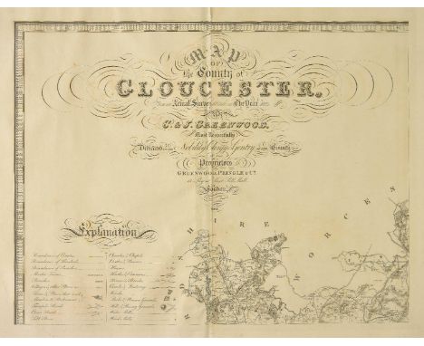
Lot 291
Gloucestershire. Greenwood (C. & J.), Map of the County of Gloucester, from an actual survey made in the year 1823, published November 22nd. 1824, large scale uncoloured engraved map on six sheets, calligraphic title, compass rose, table of explanation and a vignette of the South west view of Gloucester cathedral, slight offsetting, one sheet split along central fold, bound with later endpapers, modern half calf with contrasting morocco gilt label to spine, some scuffing to boards and extremities, slim folio (1)

Lot 293
*Herefordshire. Speed (John), Hereford-Shire described with the true plot of the Citie Hereford as also the armes of thos nobles that have bene intituled with that dignitye, published Thomas Bassett & Richard Chiswell, [1676], hand coloured engraved map, inset town plan of Hereford, 380 x 510 mm, English text on verso, framed and double glazed A large margined copy. (1)
Lot 296
Holy Land. Mercator (Gerard), Terra Sancta quae in sacris Terra Promissonis ol. Palestina , [1600 or later], uncoloured engraved map, slight creasing, central fold strengthened on verso, 355 x 555 mm, Latin text on verso, together with Blome (Richard), Jerusalem, circa 1700, hand coloured map of the city, engraved by J. Kip, margins decorated with biblical scenes and sacred figures and objects, old folds, trimmed to plate mark on three margins, trimmed with loss to printed image along upper horizontal margin, toned overall, 390 x 520 mm, mounted, framed and glazed, with Braun (Georg & Hogenberg Franz), Hierosolyma, Clarissima totius orientis Civitas Iudaee Metropolis..., circa 1580, two hand coloured engraved maps on one sheet (as published) showing Jerusalem in the first century and in the sixteenth, repaired marginal closed tears, the whole backed with tissue, 345 x 490 mm, French text on verso, mounted, plus Prideaux (H.), The Ichnography of the Temple of Jerusalem with a description of the same, circa 1740, uncoloured engraved plan with descriptive text to vertical margins, old folds, some staining, 340 x 415 mm (4)


Lot 302
Italy. Seutter (Matthaus), Nova totius Italiae cum adjacentibus Majoribus et Minoribus insulis..., Augsburg, circa 1730, engraved map with contemporary hand colouring, slight dust soiling, some marginal fraying, slight creasing, 495 x 580 mm, together with Lotter (Tobias Conrad), Mappa Geographica exhibens Regna sive Insulas Sardiniae ac Corsicae sumtibus et curis, Augsburg, circa 1770, engraved map with contemporary hand colouring, slight dust soiling, 580 x 495 mm (2)

Lot 304
Kent. Speed (John), Kent with her cities and earles described and observed, circa 1627, hand coloured engraved map, inset town plans of Canterbury and Rochester, central fold repaired and strengthened on verso, thread margins with slight loss to printed strapwork margin, 380 x 505 mm, English text on verso, together with Blaeu (Willem Jans Zoon), Americae nova tabula, [1630 - 1662], engraved 'carte-a-figures' map with contemporary hand colouring, ten costumed figures to vertical margins, nine principal cities along upper horizontal margin, inset map of Greenland, some dust soiling and staining, slight abrasion to printed surface, trimmed to strapwork margins and laid on later paper, central fold repaired, the whole backed with tissue, German text on verso (2)
Lot 305
Langley (Edward). Langley's new Map of Buckinghamshire, Langley's new Map of Huntingdonshire, Langley's new Map of Shropshire [and] Langley's new Map of Herefordshire, published J. Phelps, circa 1820, together four engraved maps with contemporary hand colouring, sectionalised and laid on linen, slight offsetting, each approximately 310 x 180 mm, each contained in a contemporary marbled slipcase, with printed label to upper cover, together with a similar map of Bedfordshire by Cole and Roper, 245 x 190 mm, with Sanson (Nicolas), Anciens Royaumes de Kent, D'Essex et de Sussex ou sont aujourdhuy les comt‚s de Kent, D'Essex, Middlesex et Hartford de Sussex et Surrey avecq la Pas de Calais..., Paris, 1654, engraved map of South-east England with contemporary outline colouring, 370 x 485 mm, plus De Vaugondy (Robert), Le Royaume d'Angleterre divis‚ selon les sept Royaumes ou Heptarchie des Saxons..., Paris, 1753, engraved map with contemporary outline colouring, 485 x 520 mm, with another nine county maps, charts and maps of the British Isles, including examples by Blair, Van Keulen, Brion, Baker, Kitchin and Cary, various sizes and condition (16)

Lot 307
*Leicestershire. Speed (John), Leicester both countye and citie described, The honorable famylies that have had the titles of earls thereof. With other accidents therein observed, 1st edition, published John Sudbury & George Humble, [1611], hand coloured engraved map, heightened with gold, inset town plan of Leicester, 385 x 510 mm, English text on verso, framed and double glazed (1)

Lot 308
Liverpool. Parry (G. H. & Preston A.), A Map of Merseyside with historical & literary allusions, published Philip Son & Nephew, Liverpool, 1934, folding colour lithographic allegorical map of the city of Liverpool and Merseyside, 490 x 740 mm, bound in publisher's printed boards, boards a little dust soiled Published for Liverpool's centenary year. (1)
Lot 31
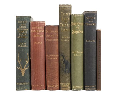
Thacker, Spink and Co. (publisher). Useful Hints to Young Shikaris on the Gun & Rifle, by "The Little Old Bear", Papers reprinted from the "Asian", 1st edition in book-form, Calcutta: Thacker, Spink and Co., 1885, frontispiece, 32 pp. publisher's advertisements dated 1890, oroginal brown cloth, extremities slightly rubbed and bumped, 8vo, together with: Selous (Frederick Courteney), Sport and Travel, East and West, 1st edition, Longmans, Green, and Co., 1900, 16 plates including frontispiece (most photographic), numerous photographic vignettes in text, original green pictorial cloth gilt, slightly mottled, large 8vo; Braddon (Sir Edward), Thirty Years of Shikar, 1st edition, Edinburgh: William Blackwood and Sons, 1895, frontispiece, folding colour map, numerous vignettes in text, light spotting to endpapers and half-title, original green cloth, spine rolled, extremities slightly rubbed, 8vo; Russell (Charles Edward Mackintosh), Bullet and Shot in India Forest, Plain and Hill, with Hints to Beginners in Indian Shooting, 1st edition, W. Thacker and Co., 1900, small section of paper disruption to upper outer corners of preliminary and initial text leaves, front free endpaper excised, endpapers spotted, bookplate of Percy Bayly Akroyd, original green pictorial cloth gilt, rubbed, wear to extremities, 8vo; [Glasfurd, Alexander Inglis Robertson], Leaves from an Indian Jungle, gathered during thirteen years of a Jungle Life in the Central Provincens, the Deccan, and Berar, 1st edition, Bombay: Times Press, 1903, 21 plates including frontispiece, original green pictorial cloth gilt, rubbed and marked, corners bumped, 8vo, and 18 others in 19 volumes, all on African or Asian big game hunting, 19th or early 20th century, original cloth, various formats (24)
Lot 311
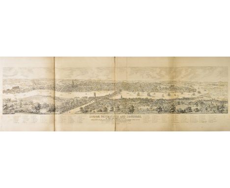
London ( ). Whittock (N.), London, Westminster and Southwark as they appeared A.D. 1543, from a drawing By Anty. van den Wyngrerde..., published Whittock and Hyde, [1871], uncoloured engraved folding panorama of the city on two conjoined sheets, old folds, slight spotting, dust soiling and offsetting, central fold partially split, 400 x 1520 mm, contemporary quarter cloth on marbled boards, bumped, worn and frayed, slim folio, together with Kelly (Thomas, publishers), Metropolitan conference. Map of Collection & Delivery boundaries for goods traffic, 1st. August, 1904, large lithographic folding map, sectionalised and laid on linen, contemporary outline colouring, 1000 x 1600 mm, marbled endpaper, index of Streets and places laid on to front pastedown, contemporary red cloth with printed label to upper cover, boards stained and worn, slim 4to, with Kelly's map of the suburbs of London, circa 1880, comprising of four uncoloured lithographic maps, each sectionalised and laid on linen, each sheet 340 x 460 mm, plus Leigh & Son (publishers), Leigh's New picture of London..., 1834, printed title, numerous uncoloured engraved views but lacking folding maps, later endpapers, modern morocco with old gilt label to upper siding, 12mo (4)

Lot 312
Malta. Raignauld (H.), Valletta citta nova di Malta, circa 1640, uncoloured engraved map, inset map of Malta and Gozzo, old folds, two worm holes affecting image, 195 x 270 mm Originally published in 'Histoire des Chevaliers de l'Ordre de S. Iean de Hierusalem'. The knights of that order having settled on Malta having been routed from their fortress on Rhodes by the Turks. (1)
![Merionethshire & Montgomeryshire. Speed (John), Merionethshire described, published George Humble, [1627], hand coloured](https://cdn.globalauctionplatform.com/bdcc24b5-51e4-450c-9a38-a98300b3d03e/5f5a5cd3-b1f7-4975-9045-a985012d1e31/468x382.jpg)
Lot 314
Merionethshire & Montgomeryshire. Speed (John), Merionethshire described, published George Humble, [1627], hand coloured engraved map, inset town plan of Harlech, large strapwork cartouche, mileage scale and compass rose, 385 x 515 mm, English text on verso, mounted, together with Blaeu (Johannes), Montgomeria comitatus et comitatus Mervinia, Amsterdam, circa 1645, engraved map with bright contemporary hand colouring, 385 x 500 mm, French text on verso, mounted (2)

Lot 317
*Norfolk. Speed (John), Norfolk, a countie florishing & populous described and devided, with the armes of such noble families as have borne the titles thereof, published Thomas Bassett & Richard Chiswell, [1676], hand coloured engraved map, inset town plan of Norwich, one small stain to image, 385 x 500 mm, mounted, framed and double glazed, English text on verso (1)
Lot 318
*Norfolk. Saxton (Christopher & Kip William), Norfolciae comitatus quem oli Iceni insederunt..., [1637], hand coloured engraved map, slight staining, 275 x 385 mm, mounted, framed and glazed, together with Ogilby (John), The road from Kings-Lyn to Norwich continued to Yarmouth in Norfolk..., [1675 or later], hand coloured engraved strip road map, 355 x 455 mm, mounted, framed and glazed, with Morden (Robert), Norfolk [1695 or later], hand coloured engraved map, old folds, some marginal tears affecting image, 370 x 580 mm, mounted, framed and glazed, plus Cary (John), A new map of Norfolk, divided into hundreds exhibiting its roads, rivers, parks &c., 1807, engraved map with contemporary outline colouring, 490 x 550 mm, mounted, framed and glazed, with three other small scale maps of Norfolk and Norwich by Dawson, Cary and Wallis, all hand coloured and all framed and glazed, various sizes and condition, plus one other (7)

Lot 319
*Norfolk. Bowen (Emanuel), An accurate map of the county of Norfolk divided into hundreds and drawn from surveys..., published T & J Bowles and Robt. Sayer, circa 1764, engraved map with contemporary outline colouring, slight overall toning, 540 x 720 mm, mounted and framed (lacking glass), together with An accurate map of the county of Norfolk divided into hundreds. Laid down from surveys and illustrated with historical extracts..., published Robt. Sayer, J. Bennett and J. & C. Bowles, 1777, engraved map with contemporary outline colouring, inset vignette of Norwich cathedral, 410 x 505 mm, framed and glazed, with Saxton (Christopher & Kip William), Norfolciae comitatus quem oli Iceni insererunt continens..., circa 1637, hand coloured engraved map, slight creasing, 275 x 380 mm, mounted, framed and glazed (3)
Lot 32
Tromholt (Sophus). Under the Rays of the Aurora Borealis: In the Land of the Lapps and Kvaens, edited by Carl Siewers, 2 volumes, 1st UK edition, 1885, colour lithographed frontispiece to each, folding map and publisher's list to volume I, illustrations, one or two light spots, ex-libris Bournemouth Natural Science Society bookplates and marks, original pictorial cloth, upper covers blocked in gold and silver, shelf number labels to spines, one corner bumped, slight lean, 8vo, together with The North West Passage, Being the Record pf a Voyage of Exploration of the Ship "Gjoa" 1903-1907, by Roald Amundsen, 2 volumes, 1st UK edition, 1908, two folding maps (one with closed tear), illustrations, light spotting front and rear, ex-libris as above, top edge gilt, original green cloth gilt, spines a little faded with tears or splits at ends and joints, shelf number labels, slight lean, 8vo, plus Nearest the Pole, by R.E. Peary, 1st UK edition, 1907, colour frontispiece, folding map, illustrations, endpapers a little toned, contemporary presentation inscription, ex-libris as above, original cloth gilt, spine a little faded with tiny tears at ends, shelf number at foot, some mottled stains, 4to, with four other polar exploration titles (12)
![*Ogilby (John). The continuation of the road from London to Holy head..., [1675 or later], hand coloured engraved strip road](https://cdn.globalauctionplatform.com/bdcc24b5-51e4-450c-9a38-a98300b3d03e/9ca7a4a0-a18c-4449-b01a-a98b00c69037/468x382.jpg)
Lot 320
*Ogilby (John). The continuation of the road from London to Holy head..., [1675 or later], hand coloured engraved strip road map, 310 x 435 mm, framed and glazed, together with Morden (Robert), The West Riding of Yorkshire, The East Riding of Yorkshire [and] Staffordshire [1695 or later], together three hand coloured engraved maps, some staining and spotting, each approximately 425 x 370 mm, framed and glazed The Ogilby map is sheet 22. (4)
![Ogilby (John). The Road from Bristol to Weymouth com. Dorset, [1675 or later], uncoloured engraved strip road map, slight spo](https://cdn.globalauctionplatform.com/bdcc24b5-51e4-450c-9a38-a98300b3d03e/53796a97-9897-4f4b-9542-a98b00c6c4f9/468x382.jpg)
Lot 323
Ogilby (John). The Road from Bristol to Weymouth com. Dorset, [1675 or later], uncoloured engraved strip road map, slight spotting, some fraying to margins but not affecting image, 345 x 440 mm Sheet number 60. The road runs from Bristol through Wells, Glastonbury, Street, Matlock and Crookhorn. (1)
Lot 325
*Oxfordshire & Buckinghamshire. Morden (Robert), Oxfordshire [and] Buckinghamshire, [1695 or later], two hand coloured engraved maps, each approximately 435 x 370 mm, mounted, framed and glazed, together with Blome (Richard),A Mapp of Warwickshire with its hundreds, [1673], hand coloured engraved map, 320 x 260 mm, mounted, framed and glazed (3)
![Persia. Ortelius (Abraham), Persici sive Sophorum regni typus, [1573], hand coloured engraved map, slight dust soiling, 350 x](https://cdn.globalauctionplatform.com/bdcc24b5-51e4-450c-9a38-a98300b3d03e/a4d0bb10-0ba1-4acb-8c66-a985012d229b/468x382.jpg)
-
109182 item(s)/page