We found 109182 price guide item(s) matching your search
There are 109182 lots that match your search criteria. Subscribe now to get instant access to the full price guide service.
Click here to subscribe- List
- Grid
-
109182 item(s)/page


Lot 464
Engraved Plates: Beattie (Wm.) Scotland Illustrated, Vol. I only, 4to L. 1838, add. engd. title, fold. map, 41 engd. plts., a.e.g., unusual full stamped mor.; also Allom (T.) The Counties of Chester, Derby, Leicester, Lincoln, and Rutland, Illustrated. 4to L. n.d. [1836], engd. title, 36 engd. plts. with 72 views, hf. mor. spine lacking, covers loose. As a coll. of prints. (2)

![Railways (Ireland): First [-Second] Report of The Commissioners .. The Manner in which Railway Communications can be most Adv](https://cdn.globalauctionplatform.com/136c6e64-89dd-4a46-bf73-a47b00ff12f7/64396abf-d04b-4919-e629-de7be718a5f1/468x382.jpg)


Lot 564
Maps: Munster & Cork: Speed (John) The Province of Munster, 38cms x 48cms, with engraved decorative border; A New and Correct Map of the County of Cork, from Charles Smiths History, 1750, approx. 51cms x 70cms; A Map of the County of Cork as in the Year 1750, engd. by D. Corbett, 38cms x 47cms, with engd. cartouche. As maps, w.a.f. (3)
Lot 565
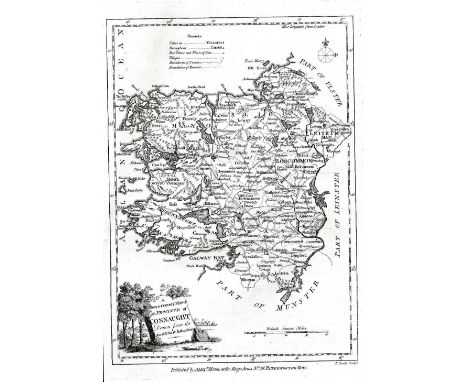
Maps - Ireland. Hogg, Alex. Four Maps of the Irish Provinces published by Alex Hogg, Paternoster Row London, c.1785. A new and Correct Map of the Province of (Ulster, Leinster, Connaught & Munster) Drawn from Latest and Best Authorities. Each map with decorative cartouche. approx. 32cms x 20cms. Constable & Co. Ireland. c.1830. Edinburgh 25cms x 19.5cms. hd.cold. Good. (5)

Lot 566
Rocque, (John) A Map of the Kingdom of Ireland Divided into Provinces, Counties and Baronies. Showing the Archbishopricks, Bishoppricks, Cities, Boroughs, Market Towns, Villages, Barracks, Mountains, Lakes, Bogs and Rivers… etc. John Rocque's large map of Ireland in 2 sheets. Large descriptive pictorial cartouche. 61cms x 98cms. hd.cold.outline. Good. (2)

Lot 567
Hondius, (Henricus) Hiberniae Pars Australis. 35cms x 48cms. hd.cold.outline.French letterpress text verso. Large one-sheet Map of Southern Half of Ireland; Ultoniae Orientalis Pars, Sumptibus Henrici Hondy. 35.5cms x 38.5cms. hd.cold. Hondius' Map of the Eastern Part of Ulster, each c. 1630. Good. (2)

Lot 570
Grand Jury Map for Co. Kildare Co. Kildare: Taylor (Lt. Alex) A Map of County Kildare, on 6 lg. sheets, approx. 24" x 32", London 1783, with lg. engraved views of Maynooth Castle, Grand Canal Bridges etc., some damp stains, all mounted on card. as a map, w.a.f. A very Scarce early Grand Jury Map. (1)


Lot 6
Waterford interest: Cunningham (Timothy) Magna Charta Libertatum Civitatis Waterford, 8vo D. (A. Long) 1752. First Edn., red & bl. title, uncut, orig. marble wrappers; Egan (P.M.) History Guide & Directory of County and City of Waterford, sm. 8vo Kilkenny n.d. First Edn., fold. map, illus. etc, cloth, gilt. (2)

![Engraved Plates: Costello (Dudley) Piedmont and Italy, from the Alps to the Tiber. 2 vols. in one, 4to L. n.d. [c. 1860] 2 p](https://cdn.globalauctionplatform.com/136c6e64-89dd-4a46-bf73-a47b00ff12f7/c8e8f2a8-0763-4d15-a499-4479e84614e7/468x382.jpg)
Lot 63
Engraved Plates: Costello (Dudley) Piedmont and Italy, from the Alps to the Tiber. 2 vols. in one, 4to L. n.d. [c. 1860] 2 port. frontis 2 add titles, fold., map, 3 dbl. page cold. maps & 141 engd. plts. some stains, hf. mor.; Ponley (Aaron) Sketching from Nature in Watercolour, folio L. n.d., add. chrome title, & 14 chrome plts. (include. frontis), orig. gilt cloth. (2)

Lot 634
Co. Offaly: Rental and Particulars of the Lands of Tubrid, .. Situate in the Barony of Clonlisk, and Kings County, .. the Property of John Clarke, of Kilballyskea,.. Sold in one Lot, on Tuesday, the 11th day of Nov. 1856, oblong 8vo D. 1856., one lg. hd. cold. map, orig. ptd. wrappers. Good; together with Co. Offaly: Landed Estates Court, Ireland: In the Matter of the Arthur Hill Griffith ... and others. Rental and Particulars of the Lands of Kilnabin, situate in the Barony of Kilcoursey, and King's County, To be Sold by Public Auction on 13th June, 1871. Lg. folio folded, D. 1871, 3 full page engd. maps, hd. cold. in outline, orig. ptd., wrappers (2)


Lot 68
With Hand-Coloured Plates Atlas: Lewis (Sam.) Atlas Comprising the Counties of Ireland and a General Map, folio L. 1846. First Edn., engd. title, lg. fold. map, & 32 full page maps, all hd. cold., orig. cloth; also I.M.C. - Simmington (R.C.) Books of Survey and Distribution - Vol. I of Roscommon, lg. oblong folio D. 1949, cloth. (2)

Lot 683
Early Cricket Almanack Boating, Cricket & Athletics: 1865 - The Cambridge University General Almanack & Register for 1865, 8vo Cambridge 1865, fold. map of river, adverts. etc., front & end, orig. ptd. wrappers, v. good. Rare. * Contains List of Officers and Crews of each of the College Boat Clubs, and a Map of the River, Officers of the University Cricket and other Clubs, and a register of the Boat Races, Cricket Matches, and Athletic Games of the Past Year. (1)


Lot 98
Birmingham (Thos.) The Social State of Great Britain and Ireland Considered, with regard to the Labouring Population, 8vo L. 1835. First Edn., 2 engd. maps, lacks fold. map? 214pp, plus Additional Statements on the Subject of the River Shannon ... 1831, 8vo L. 1834, 40pp, orig. boards, recent cloth reback. (1)


Lot 124
I.A.S.: O'Donovan (J.)ed. The Genealogies, Tribes and Customs of Hy-Fiachrach Commonly called O'Dowda's Country, 4to D. 1844. First, fold. map, lg. fold. table; also Tracts Relating to Ireland, printed for The Irish Archaeological Society. 2 vols. 4to D. 1841 - 42. First, all uniform cloth. (3)


Lot 134
Wright (Thomas) Louthiana, Or An Introduction to the Antiquities of Ireland. 4to L. 1758. Second Edn., red & bl. title (top of title repaired), engd. head on dedit & preface, sm. vignette map & other vignette illus, also 66 full page plts., some letters cut-out, some finger marks, recent boards, a working copy. S.N.S.R. (1)

Lot 147
Scarce First Edition Stafford (Thos.) Pacata Hibernia, Ireland Appeased and Reduced. Or a History of the Late Warres in Ireland. Folio L. 1633. First Edn., 2 engd. ports., lg. fold. map of Munster, + 16 (mostly) fold. maps & plts. some re-backed, complete, plus 1 extra Map of Ireland at end, 19th Century diced calf, rebacked spine dam. Scarce. (1)


Lot 18
Kilkenny: Hogan (John) Kilkenny, The Ancient City of Ossory, The Seat of its Kings, The See of its Bishops... 8vo Kilkenny 1884. First, list of subs., fold. map, plan & table; Egan (P.M.) The Illustrated Guide to the City and County of Kilkenny, sm. 8vo Kilkenny n.d. [c. 1884], First, illus. adverts etc. Both cloth. (2)
![[Wilson (W.)] The Post Chaise Companion; or, Travellers Directory through Ireland, 8vo D.n.d.Third Edn., engd. frontis, title](https://cdn.globalauctionplatform.com/136c6e64-89dd-4a46-bf73-a47b00ff12f7/9f48d3c7-0422-4a55-fb1a-73ae3bfc1938/468x382.jpg)

Lot 193
Scarce First Edition Stevenson (Robert Louis) Kidnapped Being memoirs of the Adventures of David Balfour in the year 1751. First Edn. L. (Cassell & Company) 1886, hf. title, cold. fold. map frontis (re folded) "Treasure Island" advert on verso of final leaf of text, 2 lists of adverts at end, each of 8pp & dated respectively 5G.4.86, & 5B.4.86, some stains or finger marks throughout, a couple of advert pages repaired at corners., orig. dark brown cloth. Scarce. (1)

Lot 196
Ossian: M'Callum (H. & J.) An Original Collection of the Poems of Ossian, Orrann, Ulin & other Bards, 8vo Montrose 1816. uncut, later cloth; Campbell (H.)ed. The Poems of Ossian, Translated by J. Macpherson, 2 vols. in one, 8vo L. 1822., 2 engd. frontis, wd.-cut vignette on titles, fold. map & 1 other plt., hf. mor.; another Edn., 2 vols. in one, 16mo L. 1806, hf. mor. (4)


Lot 215
The Marquis of Kildare's Own Copy I.A.S.: O'Flaherty (Rod) A Chorographical Description of West or H-Iar Connaught, ed. by James Hardiman. 4to D. (Irish Arch. Soc.) 1846. First Edn. thus, engd. map frontis, fold. pedigree, cont. diced calf, gilt fillet borders, mor. labels & tooled gilt panels & with Carton Crest in gilt on spine. V. good copy. (1)

Lot 243
Waterford etc: Rennison (Rev. Wm. H.) Succession List of the Bishops, Cathedral & Parochial Clergy of Waterford and Lismore, 8vo Waterford [1920], fold. map, cloth, v.g.; Egan's Waterford, 8vo Kilkenny n.d. [c. 1890], illus.; Maher (James) The Valley near Slievenamon, Mullinahone 1941; & 2 others. (5)


Lot 306
With Fine Lithographic Plates Paris: Charpentier (H.)publ. Paris dans Sa Splendeur Monuments, Vues, Scenes Historiques, Descriptions et Histoire, Vols. II & III, 2 vols. (ex. 3) lg. folio 1861. Full page cold. map, & 51 full page plts. some cold. tinted, orig. mor. backed gilt decor. cloth. As a coll. of plts. (2)

Lot 345
Box: Irish interest: Madden (R.R.) The United Irishmen, Their Lives and Times, 2 vols. L. 1842; Young (R.M.) Ulster in '98, Belfast 1893; Davis (F.) The Belfast Man, Earlier and Later Leaves; or An Autumn Gathering Belfast 1878; [Cusack (M.F.)] An Illustrated History of Ireland; Kenmare 1868, cold. frontis, lg. fold. map, & illus.; Lever (Chas.) The Dodd Family Abroad, L. 1872, plts. hf. mor.; Hall (Mrs. S.C.) Sketches of Irish Character, L. 1855, plts. & illus., hf. calf; Mangan (J.C.) Essays in Prose and Verse, 16mo D. (Duffy) 1906; & over 40 others of varied Irish interest, biography, history etc. As a box, w.a.f. (1)

Lot 348
Box: Leather Bindings, etc: A Collection of Scarce & Interesting Tracts, 4to L. 1795, recent 1/4 calf; Duigenan (P.) An answer to the Address of Rt. Hon. Henry Grattan, D. 1798, uncut, recent cloth; The General Laws of Estates or, Freeholder's Companion, L. 1740, calf; Wilson (R.T.) History of the Expedition to Egypt, L. 1803, calf; Giraud - The Campaign of Paris in 1814, L. 1815. hd. cold. plan frontis & fold. map, calf; & approx. 22 others, mostly leather bound; together with a bundle of pamphlets, mostly Second World War interest. As a coll, w.a.f. (1)


Lot 1123
A 17th century map engraving of Hungary by William Saxton pub. Rome 1688, to/w an engraved city plan of the Hague, datd 1560, an aerial view of Ingoldstat under siege and a 19th century map engraving of Cambridgeshire (4 - mounted, framed and glazed) Condition Report Largest map has some undulations - others good condition


Lot 640
An 18th century black and white aquatint engraving after R Smirke & J Emes showing a meeting of The Society of Royal British Archers in Gwersyllt Park, Denbighshire, dated 1794 and dedicated to His Royal Highness George, Prince of Wales, 50 x 66 cm in burrwood frame with gilt slip together with a late 18th century coloured engraving after Thomas Hearne showing Beverstone Castle, dedicated to Michael Hicks esq, dated 1778, 23 x 28 cm in gilt frame, and an unframed early 18th century map of Gloucestershire, 42 x 49 cm
Lot 617
A collection of pictures and prints relating to topography including an 18th century road map showing the route between Cirencester and Chipping Sodbury, showing the Arms of Bristol, 19 x 12 cm, a map of the Island of Sark, a pair of signed coloured limited edition prints after K W Burton showing The Clifton Suspension Bridge and Bourton on the Water, etc (all framed) together with a collection of unframed photographs relating to Concorde
-
109182 item(s)/page