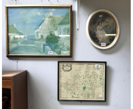
We found 109182 price guide item(s) matching your search

Refine your search

Year

Filter by Price Range
  • List
  • Grid
  • 109182 item(s)
    /page

Lot 1250

George VI cigarette case of hinged and sprung rectangular form with all over engine turned decoration and cover decorated with an engraved map of Great Britain and Ireland to a frosted gilt interior with presentation inscription, height 12.5cm, weight approx 169gms, London 1938, maker's mark SJ

Lot 242

Alexis Hubert Jaillot (1632-1712): A large engraved map of the British Isles, with hand-colouring, 60 x 93 cm

Lot 174

A Hard Back Edition of The History of the Spanish Revolution; Commencing with the Establishment of the Constitutional Government of the Cortes, in the Year 1812 and Bought Down to Overthrow by the French Arms by Joseph Hemingway Complete with Map

Lot 173

A Collection of Books Relating to Canada America and South America to Include a 1855 Edition of Prize Essays on Canada by J Sheridan Hogan (Complete with Map), 1924 Edition of The Grand Canyon of the Colorado by John C Van Dyke, 1875 Edition of Pictures of Travel in Far-off Lands: A Companion to the Study of Geography Central America, A 1909 Edition of The America Egypt a Record of Travel in Yucatan by Channing Arnold and Frederick J. Tabor Frost

Lot 464

A rare mid-20th century world map to commemorate the Coronation of King Edward VIII. A map on linen size 32cm by 22 cm. Colour. A world map showing an image of the future king (?) in a circle above the world map in two hemispheres, beneath which is a second circle containing the royal coat of arms. The British Empire and the Dominions are shown in red. Framed and glazed- full size 43 by 34 cm.

Lot 7

Two vintage wall maps by George Philip & Son Ltd., to include Philips' Comparative Map of India, Pakistan, Ceylon & Burma, 1955, 86 x 107cm; and Philips' Graphic Relief Wall Map of Australia and New Zealand, 1960, 83 x 104cm (2)

Lot 105

Framed E Bowen map of Worcestershire circa 1778, with hand coloured detail (57cm x 48cm)

Lot 106

Framed and mounted hand coloured map of Hampshire, circa 1753 by Rocque John (35cm x 32cm including frame)

Lot 284

Framed Great Western Railway route map, 64cm x 54cm Condition Report Click here for further images, condition, auction times & delivery costs

Lot 100

'Historic York', 20th century colour map after Estra Clark (British 1904-1993) pub Ben Johnson & Co, York 1947, 43cm x 65cm Condition Report Click here for further images, condition, auction times & delivery costs

Lot 35

After Herman Moll, A Map of the Western Islands of Scotland, 29cm x 22cm, framed

Lot 309

An interior scene print, five locomotive prints, map of Essex, mirror and two gilt picture frames

Lot 408

A stamped 800 fob watch, a pocket folding map of London and small clock (3) Condition Report: Available upon request

Lot 250

Two 1929 British army map reading manuals

Lot 228

The North & East Riding of Yorkshire - Carlisle to Barwick map together with various prints and oils

Lot 221

A box containing various painted lead soldiers, Britains and others, together with various trees, etc (very play worn), a four funnel steam ship model in a bottle together with a four masted model sailing ship in a bottle and a glass paperweight inscribed "MS Saga Rose the farewell voyage October 30th - December 6th 2009 Southampton-Southampton" and a Johnston's three-miles-two-inch map of England and Wales in 25 sheets, leather cased

Lot 353

An Indian silver powder compact, the top engraved with map of India and Ceylon, inscribed with the regions, set with five small rubies indicating Delhi, Karachi, Calcutta, Bombay and Ceylon, stamped "Silver 42"

Lot 357

A 'Wintz' coastal town print, a map of Hertfordshire and an oval portrait print of 'Eloisa'

Lot 633

IN THE FORBIDDEN LAND: An account of a Journey into Tibet, capture by the Tibetan Authorities Imprisonment, Torture and Ultimate Release by A. Henry Savage Landor with map and illustrations, 2vols, published in London, William Heinemann, dated 1898

Lot 343

BLACK AND WHITE PHOTOGRAPH ALBUM OF HAMBURG pictures from June 1945, with an attached scale map; a plan of Stuelckems Shipyard; another black and white photograph souvenir album of Hamburg, 1945; and various black and white photographs of shipyards, ships, submarines and bombing damage from aircraft

Lot 477

Hand-coloured map of Alderney (l'Isle D'Aurigny), 45cm x 56cm, framed and glazed, together with a facsimile map of the North and East Riding of Yorkshire after John Speed, 39cm x 51cm, framed (2)

Lot 459

Six assorted antique maps comprising: late 17th Century map of France engraved by Spofforth, another by Abrah Ortelii, French map of Scotland dated 1774 by Bonne, map of Germany circa 1700 by Homanno, British Isles 1772 published by Sayer, and French uncoloured map of Alderney (L'Isle D'Aurigni) circa 1750, each in wash lined card mount, unframed (6)

Lot 977

Framed Map of the Lands Surrounding the Bristol Channel

Lot 1024

Framed Hand Tinted Map of Jamaica and Barbados Sold By T Basset in Fleet Street & R Chiswell in St Paul's Churchyard

Lot 854

World Map Trinket Box and 3x Boxed Sets of Chinese Health Balls

Lot 2129

16th/17th century map of Persia from Ortelius' Theatrum Orbis Terrarum, , 36cm x 50cm .

Lot 2132

17th century map of Shropshire by Robert Morden 38cm x 43cm .

Lot 2116A

Eman Bowen Map depicting part of Berks, Dorset and Sussex dated 1756 18cm x 19cm another by Davies Surrey London 30cm x 42cm and another in double sided frame depicting New Zealand and Galapagos and Harmsworth Atlas and Gazetteer. .

Lot 2060

[BARRIÈRE, Dominique (c.1622-1678) and Giovanni Battista FALDA (c. 1640-1678).] Villa Pamphilia eiusque palatium, cum suis prospectibus, statue, fontes, vivaria, theatre, areolae, plantarum, viarumque ordines, cum eiusdem villae absoluta delineatione. Rome: G.G. de' Rossi [c.1675-1677] with 29 plates including map (Tavola Esatta dell antico Latio E Nova Campagna Di Roma Situata sotto il quinto Clima Dedicata All' Illme. et Eccmo. Sigre. D' Sigismondo Chigi Gran Priore Di Roma E. Sigre. Svo. Benigmo. Da Innocenzo Mattei Rom. M.C. . . .), (Title with etched device of the Pamphili arms), (view of the entrance gate to 'Villa Pamphilia' ), (3 single-page views of the fountains ) , (Veduta e prospetto del gran teatro dell'acque della Villa Aldobrandina di Belvedere a Frascati), title pages from the first and second vol.New designs of architecture, and plans of the palaces of Rome of the most famous architects), folding double page(plan of the Villa Pamphilia ), folding double page (groundplan), folding double page (Pamphiliae Villae Prospectus Tertius, Qui A Sole Oriente Prospicitur ), folding double page (Pamphiliae Villae Prospectus Secundus Austrum Excipiens a Meridie ), folding double page (Pamphiliae Villae Prospectus Primus), folding double page (Pamphiliae Villae Prospectus Quartus Solem Orientem Videns) folding double page (Pamphiliae Villae prospectus quintus ad meridiem directus ), double page (Fons Veneris ), six double page Obelisks, two double page columns, three double pages (is qui victis insultabat triumphantem, monebat) double page (triumphi maioris in urbe romana ob victorium celebrati typus), double page (Capitolii Romani Vera Imago Vt Nvnc est).
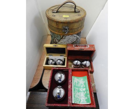
Lot 2119

19th century map of Antigua by Bryan Edwards, 18th century map of Italy, 18th century map of Malta, 18th century Map of Peloponnesus, 18th century Map Isnel Islands, and 18th century map of Sainte Lucie(6).

Lot 2126

18th century map of Hungary, 40cm x 50cm and 18th century map of Germany, 44cm x 56cm .

Lot 2360

WWII double-sided silk Chindit Panic map 'North Burma' and 'Central Burma', with notation in ink, 983331 Sgt. Murphy, Wingates Army, 1944, size of scarf 59cm x 72cm, This orange escape map was unique to the Chindits, the purpose of which is explained in Richard Rhodes James's book Chindit; Above there came the sound of planes and a Dakota appeared over the jungle followed by several others. These planes had been sent to drop more supplies on the block. Base had no knowledge of the events of the last twenty-four hours, having been out of communication, and could only assume that, though our position was grave, it was not helpless. As a matter of fact when we moved off so hurriedly a message was on its way from the General giving us permission to withdraw. We produced our 'panic maps' (silk emergency maps of bright orange colour) and started waving them. The first few lanes did not see us and we watched the parachutes floating into the hands of the Japs. But one sharp-eyed pilot noticed the streaks of orange in the nullah and emptied his load beside us. Rippingale has further added a note Cloth Map issued to the Chindits - 1944. (Also used, tied round the neck as a sweat-rag. Robert George Murphy joined the forces in March of 1940. He went on to serve all over the world most frequently posted to South Africa and admitted to hospital on several occasions. He constantly volunteered for dangerous situations, hence his time in Burma. He died at the age of 66 in Townsville Australia.

Lot 2120A

Cruchley's New Plan of London circa 1832 in slipcase with paper label. Outer case scuffs and various small losses, map comes at similar condition. maps colours strong appears to be original, no major faults found.

Lot 2125

17th century map of Scotland by Timothy Pont 'The province of Lennox, called the shire of Dun-Britton', 38cm x 53cm .

Lot 2093

Gibbon, Edward eight vols, engraved portrait to vol I, all other vols with a folding map frontis, full tan calf, London, Murray, 1855.

Lot 2117

17th century John Speed map of Huntington dated 1662 38cm x 50cm .

Lot 2131

17th century map of Worcestershire by John Speed, dated 1610, 39cm x 52cm .

Lot 2124

17th/18th century map of Scotland 'Scotia Regnum' by Frederick de Wit, 57cm x 50cm .

Lot 2110

William F Ainsworth: A Personal Narrative of the Euphrates Expedition, 1888, first edition, two volumes, folding map, original cloth.

Lot 2111

Walter B. Harris: A Journey through the Yemen and some General Remarks upon that Country. Published by William Blackweed, 1893 1st edition, illustrations and maps throughout, folding map towards the rear, green board and spine.

Lot 2122

John Speed map of Scotland, with inset full-length portraits, . overall condition appears to be good, no creases or tears. slightly coming away at fold line approx 10cm, colours are strong, possible been retouched around the sails and other retouched decoration, part cm margin around edge. overall slight discolouration.

Lot 2130

16th/17th century John Speede map 'The Kingdome of Persia with Cheef Citties and Habites defcribed, 40cm x 52cm . Various creases, small tears around central fold line. colours strong and appear to be original, approx cm margin around all sides, no major faults found.

Lot 2091

Shackleton (Ernest, Sir) South, The Story of Shackleton's Last Expedition, 1914-1917, Heinemann, 1919, first edition, colour frontis, monochrome plates as called for, folding map, original cloth.

Lot 2128

Pieter van den Keere, map of DorcetShire (Dorset), late 16th century, 8cm x 12cm.

Lot 2123

John Ogilby, The Road from Gloucester to Coventry,. original 17th century map, framed and glazed no visible tears or creases, colour is strong, margin approx 2mm around the edges

Lot 2121

16th century John Speede map of Surrey 38cm x 52cm .

Lot 798

Original Robert Morden map of Northamptonshire framed and glazed 37 x 42 cm CONDITION REPORT: Reasonable condition, some foxing and folds.

Lot 318

Maps - Survey of Cyprus administration and road map (1971)

Lot 338

Maps " The reaches of New York City" 1939 by National Geographic Magazine; "The Royal Aimee Atlas of the British Empire" 1935 by John Knight, Royal primrose Soup Works; "War map of Far east, Libya + Egypt" News Chronicle (taped) (4) Geographical Magazines

Lot 323

Maps - Bacons Cycling + Motoring London District; Surrey; peninsular Campaign map, Well used, mixed condition

Lot 316

W H Smith & Son's New & Up to Date Cycling, Touring and Motoring Road Map of 70 Miles about Manchester. Mounted on cloth, opens out to approx. 38in by 29.5in, scale half an inch to a mile.

Lot 136

Egypt and Cyrenaica 1:250,000 series - sheet 5 Sidi Barrani - Matruh. MDR 1006/1557. Folding map in colour 25 by 35 inches compiled, drawn and printed by 19th Field Company RE June 1942. Paper map misfolded but otherwise in good state. (1)

Lot 331

Castor's-Map of seventy Miles Round, Peterborough-no date on booklet

Lot 322

Maps - A range with Bacons cycling Road Map of Lancaster "Geographical" Pictorial Plan of London, "Geography" Large scale Road Map of Sussex in very good condition. Also Ward Locke 'The Cotswold' Bartholomew North Somerset & others - these are well used. (8)

Lot 257

James Rofs (British 18th century) Two views of the Borough of Bewdley in Worcestershire, a pair Coloured engraving Each 46 x 56.5cm (18 x 22 in.) Provenance: The Parker Gallery, London Together with two further coloured engravings, one after James Sherriff, A South West Prospect or Perspective View of Stour Port, the other after A. Managcot, A View of the Town and Harbour of Portsmouth with his Majesty’s Fleet under Sail, by Scotin, an 18th century map of Worcestershire, and another map of Worcestershire by Christopher Saxton, all various sizes, the largest 55 x 73cm (21 6/8 x 28 3/4in.) (6) Provenance: The Property of a Lady of Title, Ripple Hall, Gloucestershire

Lot 26

A late 18th century map of The Past Roads of Germany by F J Heger

Lot 59

A FRAMED AND GLAZED ENGRAVING OF WHITBY BY FRANK H. MASON TOGETHER WITH AN ORIGINAL FRAMED AND GLAZED JOHN CARY MAP OF WARWICKSHIRE TOGETHER WITH A WATERCOLOUR OF A COASTAL SCENE SIGNED LOWER RIGHT (3)

Lot 435

An 18th century map depicting Cheshire, coloured engraving, 26cm x 21cm, J Carey, London 1793, together with a 19th century map depicting Warwickshire, 18cm x 24cm, Drawn And Engraved For Lewis Topographical Dictionary, both glazed and framed.

Loading...Loading...
  • 109182 item(s)
    /page

Recently Viewed Lots