

A Map of New France Containing Canada, Louisiana &c. in Nth. America... This interesting map depicts the French possessions in North America in the early part of the eighteenth century. New France included Canada and the proprietary colony of Louisiana, which included the former Spanish possessions in Florida. In 1712, King Louis XIV selected Antoine Crozat, the Marquis de Chatel, as the proprietor for Louisiana. Crozat was granted a monopoly on trade for fifteen years, but failed to develop the colony and relinquished his rights in 1717. The map is filled with information including colonial settlements, Indian villages, and forts. The British colonies are confined east of the Appalachian Mountains. The Great Lakes are presented in a strange format and La Hontan`s R. Longue is shown in the upper left. The route of the Spanish treasure fleet is shown in the Gulf of Mexico and around the tip of Florida. Published in London in Thomas Salmon`s Modern History: or the Present State of All Nations. A superb impression on watermarked paper with scattered foxing confined to the blank margins. 7.2"" W x 10.2"" H Moll, Herman 1745
We found 109198 price guide item(s) matching your search
There are 109198 lots that match your search criteria. Subscribe now to get instant access to the full price guide service.
Click here to subscribe- List
- Grid
-
109198 item(s)/page

A New Map of North America from the Latest Discoveries This is the uncommon first state, not the 1763 edition from London Magazine, of this fine map noting the colonial possessions in North America eastward from Texas to the Atlantic coast. It shows early settlements, forts, Indian villages, and tribal territory. The colonies have boundaries extending past the map`s western border. Various treaty and charter boundaries are shown. Earl Granville`s Property stretches from the Atlantic west to beyond the Mississippi River. In Florida, a line from Fort St. George to St. Mark delineates the Limits Stipulated in 1738 and below, nearly to Cape Canaveral, are the Bounds of Carolina by Charter of 1665. The fishing banks off Canada are prominently outlined. The map is enhanced by a delicate title cartouche and fancy compass rose. Issued folding on watermarked paper with a few spots of printer`s ink residue. A binding trim at right has been replaced with old paper, and an associated 1"" binding tear has been closed on verso with archival tape. 10.8"" W x 14.8"" H Spilsbury, J. 1761

The British Governments in Nth. America Laid Down Agreeable to the Proclamation of Octr. 7. 1763 This great map was designed to illustrate the new boundaries established at the end of the French and Indian War when England came into possession of the former French and Spanish settlements in Canada and Florida. It covers the east coast from Newfoundland down the coast to East and West Florida, the Bahamas, inland including the Great Lakes and French Louisiana. The large Lands Reserved for the Indians lies west of the Appalachians. Each colony is shown with a wide engraved line. Large inset illustrates Bermuda or Summer Islands. Compass rose with the fleur-de-lis decorate the strong engraving.See also lot 766 for Fite and Freeman`s excellent reference work, which describes this map. Originally issued folding, now flat, with light soiling, a few short archivally repaired tears and fold separations, and some tiny worm holes that are only visible when held up to light. 8"" W x 9.2"" H Gibson, John 1763

A Correct Map of the United States of North America. Including the British and Spanish Territories, Carefully Laid Down Agreeable to the Treaty of 1784 This early map of the United States was created at the conclusion of the American Revolution, after the Treaty of Paris. The western boundary is along the Mississippi River. The western region is full of information up to Lake Winnipeg, with Indian names and interesting notations such as Extensive Meadows Full of Buffalos, north of the Missouri River, and Country Full of Mines, just north of Arkansas. Issued folding, now flat, with light soiling. A couple short fold separations at bottom have been archivally repaired. 12.4"" W x 17.6"" H Bowen, Thomas 1787

A Correct Chart of the East Coast of North America Engraved for Malham`s Naval Gazetteer This handsome chart traces the coast of the young United States north to Canada. Although no borders are shown, a majority of the early states are named, including Vermont and Kentucke, the latest additions to the nation at the time of publication. Numerous towns and major cities, Indian tribes, harbors, sounds, banks, and more are located. The name Indiana appears despite the fact that the map pre-dates the creation of the Indiana Territory in 1800. A note by Salvador or Guanahani (San Salvador) in the Bahamas reads, ""First Land seen by Columbus 1492."" There is a compass rose capped with fleur-de-lis in the Atlantic that radiates rhumb lines. The chart was engraved by Neele for Rev. John Malham (1747-1821), a writer and teacher of navigation, for a British edition of The Naval Gazetteer; or, Seaman`s Complete Guide. Issued folding with a hint of offsetting and minor toning along sheet`s edges. 9.4"" W x 7.4"" H Malham, John (Rev.) 1795

Carte des Lacs du Canada pour Servir a l`Histoire Generale des Voyages This is an excellent French & Indian War period map depicting the five Great Lakes. While this map uses the same title as Bellin`s prototype map of the Great Lakes, published in Charlevoixs Histoire et Description Generale de la Nouvelle France in 1744, it has been updated with information from Bellin`s similar map of 1755. Lakes Erie and Ontario are more accurately defined and the spurious islands in Lake Huron have been eliminated. However, several large, bogus islands still remain in Lake Superior, including I. Minong (called I. Philippeaux on some issues) and I. Pontchartrain. The Michigan peninsula is still misshapen with a massive mountain range down its center. Numerous forts are located: S. Jgnace, Niagara, des Miamis, and Toronto to mention a few. The ornate rococo title cartouche is draped with ivy.See also lot 766 for Portinaro and Knirsch`s excellent reference work, which describes this map. A clean, bright example, issued folding on watermarked paper with minor offsetting and a binding trim at top left replaced with old paper. 7.8"" W x 11.5"" H Bellin, Jacques Nicolas 1757

A Plan of the Straits of St. Mary, and Michilimakinac, to Shew the Situation & Importance of the two Westernmost Settlements of Canada for the Fur Trade Uncommon map of the region where the fur trade flourished during the colonial period. Mackinac and Sault Ste. Marie each commanded a narrow in the Upper Lakes system, thus exercising great influence in the fur trade and became strategic sites for military activity. The map is densely engraved to depict the mountainous and forested landscape and is filled with interesting notations concerning the Indian inhabitants. Locates the Mission of St. Mary and Mission of St. Ignace, as well as the ""Common Track of the Vessels to the Detroit &c."" Lake Superior is noted as ""Worship`d as a Divinity by the Indians."" Decorated with a delicately engraved title cartouche and a fleur-de-lis. Issued folding with one tiny fold separation repaired on verso with archival material and a binding trim at lower left replaced with old paper. 9.3"" W x 12.6"" H Anon., 1761

A New Map of Upper & Lower Canada This small map is centered on the Great Lakes and extends from Lake Winnipeg in the west to the mouth of the St. Lawrence and Anticosti Island in the east. There is nice detail of watersheds, shoreline and the southern portion of James Bay. The map locates a number of important forts including Ft. Chambly and Ft. George. Issued folding on watermarked paper with light scattered foxing. 6.8"" W x 9.1"" H Stockdale, John 1798

A Chart of North and South America, Including the Atlantic and Pacific Oceans, with the Nearest Coasts of Europe, Africa, and Asia This is the top portion of Thomas Jefferys` large and important three-part map of the Americas, compiled in 1753 by Braddock Meade, one of the most intriguing figures in British cartographic history as well as an extremely gifted mapmaker. Working under the alias John Green after serving time for defrauding an Irish heiress, Meade compiled many of Jefferys` most important maps. The portion here focuses on the Arctic explorations into Hudson and Baffin Bay and on the Pacific Northwest coast. A complete map that stands on its own, with full borders, this was partly designed to expose the errors in Delisle and Buaches map of the Pacific Northwest. This is the first map to label Bering Strait and is quite detailed, with a plethora of information on the explorers and their discoveries shown in various ways throughout the map. The tracks of Hudson and Baffin are shown and accented with sailing ships. Of particular interest are the tables at the top and left, which show the variations in latitude and longitude between Jefferys`` chart and those of Bellin, D`Anville, Moll, and Senex. There are indignant notes on the Pacific Northwest - ""These parts, as yet wholly unknown are filled up, by Messrs Buache and Delisle with the pretended discoveries of Adm. de Fonte and his Captains in 1640."" It also includes numerous notations concerning Russian explorations and presents a bulbous shaped Peninsula of the Tchuktschi whose Extent and Dimensions are unknown Alaska, named here Alaschka is shown as a large island in the Anadirskiai Islands. This is an engrossing map, and a wonderful addition to any collection of the Pacific Northwest or Arctic. Two joined sheets, as issued.Jefferys was the leading English cartographer of the 18th century, serving as both Geographer to the Prince of Wales, and later, Geographer to the King, positions that granted him access to the best surveys conducted in America. He published a series of maps of the American colonies that were among the most significant produced in the period, including the Fry/Jefferson map of Virginia, Braddock Meades map of New England, and William Sculls map of Pennsylvania and the western frontier. His successors, Sayer and Bennett, gathered these separately-issued maps together and republished them as The American Atlas. According to Ristow, ""[The atlas] was, very likely, consulted by American, English, and French civilian administrators and military officers during the Revolution."" A nice impression on watermarked paper with light soiling. There are professional repairs to two tears that enter 1"" to 2"" into map at top left and two fold separations confined to the top blank margin. The bluish shadow on the scanned image is a result of the scanner and does not appear on the map itself. 17.9"" W x 43.6"" H Jefferys/Sayer & Bennett, 1775

A Map Shewing the Communication of the Lakes and the Rivers Between Lake Superior and Slave Lake in North America This intriguing map is based on the map and report by Peter Pond in 1787. The map traces the route from Lake Superior to Lake Winnipeg and then through an interconnected chain of lakes and rivers to Arabaska Lake and Slave Lake. The most interesting feature is the speculative river flowing out of Slave Lake, over ""falls said to be the largest in the known world,"" and emptying into Cook Inlet in Alaska, a remarkable journey considering the topography. Pond`s map influenced Alexander Mackenzie`s quest to find the Northwest Passage in his famous expedition in the region. Published in the March 1790 issue with no attribution to the engraver. A crisp impression issued folding with a hint of offsetting and a few minor creases. Narrow right margin. 7.8"" W x 9.3"" H Anon., 1790

Carte pour Servir au Voyage des Capes. Lewis et Clarke, a l`Ocean Pacifique This is a very early map illustrating the Lewis and Clark expedition, and locates parts of their route from the mouth of the Missouri River westward through North America to the Pacific Ocean, during the years 1804-1806. Wheat notes that ""Tardieu had no Lewis and Clark map to assist him, but he apparently had at hand Meriwether Lewis`s brief letter-report to Jefferson, and he did his best to locate on his map at least a few of the Expedition`s points of geographic interest. His available topography, based as it was on Soulard, was both skimpy and erroneous, but his use of the quoted legends showed much ingenuity."" This map was published in the first French edition of a journal about the expedition written by Patrick Gass, who accompanied Lewis and Clark on their expedition. This map was not included in Gass` first edition of his journal, The Corps of Discovery, which was published in 1807. Issued folding with light offsetting, minor soiling, and a tear that enters 1"" into map at right that has been professionally repaired. Remargined at right to accommodate framing. 9.6"" W x 7.9"" H Tardieu, Jean Baptiste Pierre 1810
![[Lot of 4] View of the Country Round the Falls of Niagara [and] View of the Country Round Pittsburg [and] View of the Countr](http://lot-images.atgmedia.com/SR/36385/2916721/125-2014116143429_468x382.jpg)
[Lot of 4] View of the Country Round the Falls of Niagara [and] View of the Country Round Pittsburg [and] View of the Country Round Zanesville [and] Falls of Ohio These four small regional maps are from one of Melish`s important early 19th century descriptions of the young United States. Each map focuses on the transportation network of these strategically located cities. John Melish was the first American publisher to concentrate on cartographic and geographic publications. Born in Scotland, Melish immigrated to Philadelphia in 1811. In 1812 he published Travels in the United States of America, which included his first maps. He soon came to dominate the industry in this country, and had a huge impact on all subsequent American map-making. On thick paper with some faint foxing. 6.6"" W x 4.2"" H Melish, John 1812

United States Map shows the extent of the early United States with Missouri, Arkansas and Louisiana demarcating the western frontier. Texas is part of Mexico and an unnamed Missouri Territory reaches westward including the Great American Desert where several Indian Districts are named. The Huron District takes the place of Wisconsin and the Upper Peninsula of Michigan. Oregon District takes in present-day Oregon and Washington and encroaches slightly into present-day British Columbia. An unnamed river links L. Timpanogos with the Pacific at the Bay of Sir F. Drake. The map is filled with early towns, settlements and mines. Original outline color with a few minor spots. 7.7"" W x 10"" H Bradford, Thomas Gamaliel 1835

The United States & The Relative Position of the Oregon & Texas This interesting map depicts the United States in the midst of dramatic westward expansion, just after the annexation of Texas and just prior to the Mexican-American War. The map shows several previous and proposed western boundaries. In the Pacific Northwest there is the Line Proposed by the Convention of the 20th October 1818, the Line Proposed by the Americans in 1824 & 1826, and the Line Proposed by the English in 1826. This region was still in dispute at the time this map was published. The Line of the Treaty of Florida of the 22nd February 1819 and of 12th January 1828 forms the U.S. boundary with Mexico and the northern border of Texas. The Line Proposed to Mexico by the United Sates in 1835 shows an obscure proposed boundary roughly on the 37th parallel. Texas is shown in its largest configuration with the panhandle elongated to include the panhandle of present-day Oklahoma, and parts of New Mexico and Colorado. Mounted on linen to reinforce and repair two 5"" edge tears with a 5"" x 2"" section along and above the top left border that has been replaced with another example of the map. There is light soiling and several additional edge tears that are mostly confined to the blank margins. 15"" W x 21.5"" H Wyld, James 1845

Map of the United States Including Oregon, Texas and the Californias This unusual broadside map depicts the United States and Mexico during the Mexican-American War. It shows a small New Mexico Territory situated between the new state of Texas and the disputed area of New California. There is a red line following the Platte, Snake and Columbia Rivers labeled the ""Route of Oregon Emigrants."" Below the map is a large text panel describing the Seat of War, U.S. military history, and brief summaries of Texas, Oregon and Mexico. Full sheet with text measures 17.1 x 22.9"". Moderate toning and soiling with light overall creasing and numerous small edge tears and chips, a few of which enter the border that have been repaired on verso with old paper. There are a few pieces of masking tape on verso that have stained the sheet along the right border. 10.6"" W x 15.3"" H Haven, John 1846
![[Untitled - United States] This map shows the new state of Texas with its northern boundary extending to 42 degrees N. latit](http://lot-images.atgmedia.com/SR/36385/2916721/129-2014116143434_468x382.jpg)
[Untitled - United States] This map shows the new state of Texas with its northern boundary extending to 42 degrees N. latitude. Additional transitional territorial configurations are depicted, including a large California Territory extending nearly to Texas with a small version of New Mexico sandwiched in between. Within California are early references to the gold-related Nueva Helvetia and Sutter`s Fort. Sometimes referred to as the `Tables Map` because a table on each side of the map offers selected statistical information including details on the ""Three Divisions"" of Texas. The map contains interesting versions of treaty boundaries drawn and a table of explanations provides treaty dates. Wheat says the map was likely prepared for the General Land Office to show 1848 Guadeloupe-Hidalgo treaty lines. Hand coloring is used to indicate other treaty boundaries including Great Britain 1783; Spain 1795; France 1803; Spain 1819; Great Britain 1842 & 1846; and Mexico 1848. Lithographed by Duval in Philadelphia. Issued folding with moderate toning along the folds and a few small spots. There are a number of short fold separations as well as a 2"" binding tear at left, all of which have been archivally repaired. A binding trim at bottom left has been replaced with old paper. 13.8"" W x 33.4"" H Gilman, E. 1848

De Vereenigde Staten van Noord-Amerika This map of the United States shows evolving configurations in the western territories. Oregon stretches from the Pacific to the Rockies including present-day Washington, New Mexico extends to include southern Colorado, and a large Nebraska Territory occupies the region from the Rockies east to the Missouri River. There is good detail of the river system and topography with numerous Indian tribes named. Engraved by D. Heyse. Original outline color with minor soiling in the lower right corner of the sheet, mostly in the blank margins. 8.2"" W x 11.1"" H Baedeker & Company, 1850

United States This great Civil War map covers the entire United States and depicts the Union states, Confederate states, border states and Indian Territory. A large section from Texas to California is left uncolored with the Missouri Compromise line following the 36th parallel in this region. Arizona is shown occupying the southern section of New Mexico territory, likely referencing the Confederate Territory of Arizona. The detailed map shows railroads, rivers and topography via hachure. Published by London Printing & Publishing. Issued folding with a few spots of foxing, minor toning, and a short binding tear that just passes the neatline at right closed on verso with archival tape. 10.8"" W x 16.9"" H London Printing & Publishing, 1861

Carte Illustree des Etats-Unis d`Amerique Montrant les Ressources, Produits, Topographie, et Principales Caracteristiques Regionales This spectacularly illustrated French map of the United States was published by the U.S. Office of War Information during World War II. All of the 48 states are shown with major cities identified. Hundreds of small illustrations serve to highlight the products, culture, and notable sites in each state. In addition to a title cartouche, there are three inset maps showing the railroads, airways, and interstates, and an inset focused on facts about America. Clean and bright with a few short edge tears confined to the blank margin, otherwise fine. 23.4"" W x 31.3"" H 1944

An Accurate Map of the English Colonies in North America Bordering on the River Ohio This unusual map of the colonies spans from the Carolinas north to the Great Lakes and Casco Bay off the coast of present-day Maine. It was published in the December 1754 issue of Universal Magazine, in the beginning months of the French and Indian War, which helps to explain the wishful configuration of the colonies. Although the coast is rendered with relative accuracy, the colonies appear in distorted form, extending farther to the north and to the west than is correct. South Carolina stretches farther north than the relatively small North Carolina, while Virginia, Maryland, and Pennsylvania push past the Appalachians and Ohio River into French territory. Cities and towns (among them Boston, Philadelphia, Jamestown, and Plymouth), rivers, Indian tribes, forts, and more are located, and Niagara Falls is shown with a note that it is a ""160 foot"" drop. Issued folding, now flat, with a few faint spots. The sheet has been remargined with old paper at bottom with a portion of the border replaced in facsimile. 7.9"" W x 9.6"" H Anon., 1754
![[Untitled - Louisiana, Virginia & Carolina] This interesting map was issued to illustrate the part of Louisiana being ra](http://lot-images.atgmedia.com/SR/36385/2916721/135-2014116143446_468x382.jpg)
[Untitled - Louisiana, Virginia & Carolina] This interesting map was issued to illustrate the part of Louisiana being rapidly settled by British subjects at the conclusion of the French and Indian War. It is full of fascinating details including the locations of Indian tribes and villages, gold mines, forts, and frontier outposts. The colonies of Virginia, Carolina, and Georgia are named, as is Florida. A line along the Appalachians is labeled ""Formerly the French claim`d all ye Country Westward of this Line."" Large expanses of country are shown belonging to various Indian nations. In present day Texas is Country of the Cenis, Gr. Village of the Cenis, and The Garrison of the North or of St. John Baptist in the region of El Paso. A large river and lake west of the Mississippi is identified as The Great River according to M. de la Hontan. Issued folding with faint offsetting. 7.1"" W x 9.5"" H Gibson, John 1763

Carte de la Louisiane et du Cours du Mississipi avec les Colonies Anglaises This is the updated version of Delisle`s influential map of the French possession of Louisiana that drew together the cartographic work of the previous half century and had a tremendous impact on the history of cartography. When originally published in 1718, it was the first detailed map of the Gulf region and the Mississippi, and the first to show the explorations of De Soto, Cavelier, Tonty, Moscoso and Denis. The map was designed for the political purpose of invalidating the English claims west of the Appalachian Mountains and laid claim to Carolina by the French, which provoked an angry English response. However, it is the cartography of the Mississippi Valley for which the map is notable today. The name Texas made its first appearance in print on this map, with the legendary Mission de los Teijas, established in 1716. The notation of Indiens errans nommes Chetis along the Gulf Coast is changed from the earlier editions, which noted that they were anthrophages, or cannibals. An inset of the Mississippi Delta and Mobile Bay fills the lower right corner. This is the Dezauche edition, which is a reissue of the second state of the original plate, showing the settlement of New Orleans, founded in 1718. A fine impression on watermarked paper with original outline color, a hint of offsetting, two short printer`s creases adjacent to centerfold, and one unobtrusive spot at bottom center. 19.3"" W x 25.6"" H Delisle/Dezauche, 1782
![[Map and 3 Text Volumes] Carte Generale des Etats de Virginie, Maryland, Delaware, Pensilvanie, Nouveau-Jersey, New-York, Co](http://lot-images.atgmedia.com/SR/36385/2916721/137-2014116143449_468x382.jpg)
[Map and 3 Text Volumes] Carte Generale des Etats de Virginie, Maryland, Delaware, Pensilvanie, Nouveau-Jersey, New-York, Connecticut, et Isle de Rhodes...[and] Lettres d`un Cultivateur Americain This is an updated French edition of Evans` rare and important map of the Middle Colonies that was first published in 1755. It was produced for St. John de Crevecoeur`s book and includes some additions in New England, but fewer than the extensive additions of Pownall`s 1776 reissue, according to McCorkle. Engraved by Pierre Francois Tardieu. Highly detailed, the map covers the frontier, not just the better known populated areas of the states. It extends to include Lakes Ontario and Erie, and the St. Lawrence River to Montreal. The map randomly uses French or English for the scores of place names, while most notations and the legend are in English. A large inset at upper left ""Esquis se duresse de la Riviere de l`Ohio"" shows the course of the Ohio River to the Mississippi and up to Lakes Michigan and Huron. The French had better knowledge of the Great Lakes area as evidenced by additions on this map not found on the original Evans. For example, the Portage of Chikago, Fort Erie, and St. Louis are shown and the Niagara River valley contains more detail of the watershed in the region. De Crevecoeur also included updated information in New England particularly in Vermont, where Dartmouth College, Putney, Bennington, and Westminster are located. Kentucky is erroneously named as a state and there are early references to important cities in the region like Louisville and Leestown, which was the first Anglo-American settlement on the north side of the Kentucky River and is now part of Frankfort. The map names Indian tribes and a legend explains their status: Extinct; Nearly extinct; and those that are Still considerable. Included with the map are the three matched volumes of text, including an untitled bridge plate over the Shetuket River near Norwich, CT. Volume 1 (478 pp.), volume 2 (438 pp.), volume 3 (592 pp.). Octavo, hardbound in original full calf with gilt title on red labels on spine, marbled endpapers and all edges gilt. A very attractive map with complete text.See also lot 773 for Schwartz and Ehrenberg`s excellent reference work, which describes this map. The map is issued folding with faint offsetting. A 0.5"" fold separation and an adjacent 1"" tear near the center of the map image have been closed on verso with archival tape. Text is clean and tight and front hinges are starting. Covers are lightly rubbed with bumped edges. 18.9"" W x 25.8"" H Crevecoeur, Michel Guillaume De 1787

A Map of the United States of America, with Part of the Adjoining Provinces from the Latest Authorities This uncommon map presents a pre-Tennessee configuration. The map covers the region from the eastern seaboard to the Mississippi River. The Western Territory takes in all the area west of the Ohio River with several Indian tribes located and areas of ""Extensive Meadows"" in today`s Illinois. Kentucky occupies a larger area that appears to include part of today`s West Virginia. A large unnamed territory in the region of Mississippi and Alabama is the tribal territory of the Chicasaws, Cherokees, Chactaws and Muskogees. In the Northeast Main is noted as belonging to Massachusetts Bay. Engraved by T. Conder. Original color with minor soiling confined to the blank margins. 8.5"" W x 11"" H Wilkinson, Robert 1791

A New and Accurate Map of the United States of America, &c. from the Best Authorities A very scarce little map from the first general atlas published in Scotland. The map covers the region from the eastern seaboard to the Mississippi River. Western Territory takes in all the area west of the Ohio River with several Indian tribes located within it. Kentucky occupies a loosely organized region west of Virginia. In present-day Tennessee, the North Carolina land grants of Cumberland and Holstonare located, extending North Carolina in an odd configuration. An unnamed territory in the region of Mississippi and Alabama is the tribal territory of the Chickasaws, Cherokees, Choctaws, and Muskogees. Main is noted as belonging to Massachusetts Bay. A 136 foot Niagara Fall is located, as is the Country of the Six Nations. Engraved by John Menzies. A dark impression with a faint damp stain that just enters the image at top right. 10.6"" W x 13.1"" H Brown, Thomas 1793

States of America, Drawn from the Best Authorities Guthrie first published this map circa 1785 as A Map of the United States of America Agreeable to the Peace of 1783, with continuing updated editions. This 1801 issue shows five divisions of land in southern Ohio named Seven Ranges, Army Lands, Ohio Company, Donation Lands from the Commonwealth of Virginia, and Col. Simmes. At the junction of the Ohio and Mississippi rivers can be found Illinois Company, Wabash Company, New Jersey Company, and Army Lands. South of the Ohio River, in present-day northern West Virginia, is a chunk of land named ""Indiana"" which rests just below the Seven Ranges. The Twenty Leagues Line is drawn in the coastal Atlantic. Kentucky and the Tennessee Government appear, and Georgia`s boundary extends to the Mississippi River with numerous Indian tribes noted, primarily in the western portion. Maine lacks its northern tip. Lake Superior appears without its imaginary islands, Michigan is nearly blank with the name Utawas at its center, and several Indian tribes are located in the Wisconsin/Minnesota area, where little else is shown. There are a few stains at top left and right and some minor extraneous creases. There are professional repairs to a centerfold separation at bottom, a 2"" tear to the east of the Carolinas, and a few small chips and tears confined to the blank margins. 15.7"" W x 18.1"" H Russell, John C. 1801

Charte von den Vereinigten Staaten von Nord-America nebst Louisiana... This uncommon map depicts the United States in the early part of the nineteenth century. There are some unusual configurations west of the Appalachians including an Indiana Territory that extends from Manitoba to New Madrid, Missouri as well as an oddly shaped Ohio. Tennessee extends too far to the east and an unnamed region occupies the space between Georgia and the Mississippi River. Louisiana is still shown as a French possession and Florida is divided between East and West. Numerous Indian tribes are named and located along with good detail of the river system. On watermarked paper with light creasing at right and minor soiling primarily confined to the blank margins. 18.6"" W x 26.9"" H Weimar Geographisches Institut, 1805

The United States of America Confirmed by Treaty. 1783 This small map of the young United States includes several important historical regions. One of the most unique and scarce features on early maps of the U.S. is the appearance of Franklinia. In 1785 settlers in present-day western North Carolina and eastern Tennessee organized a state government to be named in honor of Benjamin Franklin. Congress turned down their appeal but the fledgling state maintained a legislature and governor until 1788. This ephemeral state appeared on only a small number of maps into the early part of the 19th century. Another interesting feature is the region labeled Indiana that appears in what is now West Virginia. This land was a major contention between the private Indiana Land Company and the State of Virginia in the latter part of the 18th century. The argument over ownership of the property resulted in the Eleventh Amendment to the U.S. Constitution and the Indiana Land Company lost its claim to the land. Another uncommon regional name is New Iberia, the original Spanish settlement in the region of New Madrid, Missouri. The large Western Territory takes up present-day Michigan, Wisconsin, Illinois, Indiana, and Ohio. A table below the title lists twenty states, territories, and governments (including Franklinia) with their founding dates. Engraved by B. Smith and published by Hamilton Adams & Co. Original color on a sturdy sheet with a hint of toning. 9.8"" W x 11.3"" H Wilkinson, Robert 1812

United States of America This map of the United States extends west to the Rocky Mountains and provides a detailed view of the region based on information from the expeditions of Lewis & Clark and Pike. A notation at the western edge of the map shows where ""Clarks Canoes stop 3000 miles from the Mississippi."" The Missouri Territory takes in the entire northern plains region from the Mississippi to the Rocky Mountains. The new state of Missouri is presented with preliminary boundaries and Arkansas is shown at its largest extent. Today`s Minnesota and Wisconsin are here a part of North West Territory. In Texas there are a few place names including Ft. Matagorda, but Galveston is poorly located. Texas and the Southwest are a part of Mexico. One of the most interesting features of the map is the river system in the West, near the Highest Peak, where the headwaters of several major rivers all originate within a few miles of one another - Red River of California (Colorado), Multnomah (Willamette), Rio del Norte (Rio Grande), Arkansaw (Arkansas), and the Platte. This edition includes a notation in the Gulf of Mexico explaining the sources of the map and noting that recent surveys made by Major Long have been incorporated where ""the mistakes were very palpable."" Engraved by Benjamin Tanner. A nice impression with minor uneven toning, light soiling, and an edge tear at bottom that just touches the neatline and has been closed on verso with archival tape. A small piece of cello tape is located along the bottom centerfold on verso creating a faint stain on recto. 17"" W x 21.4"" H Melish, John 1827

Nova Belgica et Anglia Nova Jansson`s influential map of the eastern coast of North America was first issued in 1636 with a less decorative title cartouche. It is derived from the less well-known 1630 map of Johannes de Laet, which is generally regarded as the source map for New England and the Northeast. It includes several very early depictions of colonial settlement including Manhattan and the Dutch colony of New Amsterdam, the Nordt Rivier (Hudson) and Zuydt Rivier (Delaware), along with Massachusetts and the English colony at Plymouth. The map includes part of the Great Lakes labeled Grand Lac and Lac des Yroquois, an unnamed Lake Champlain, and a fictitious lake at the headwaters of the Delaware River. In the second state, the title was shortened, giving greater prominence to the Dutch colonies, and wildlife was added throughout the interior. It is beautifully adorned with cartouches, ships, sea monsters and compass roses. Spanish text on verso, published between 1653-66.See also lot 764 for Cumming`s excellent reference work, which describes this map. A clean and bright example with minor show-through of text on verso and marginal soiling. There are a few short tears in the blank margins, far from image. 15.3"" W x 19.9"" H Jansson, Jan 1653

A Map of 100 Miles Round Boston Interesting and very early Revolutionary War map extending to the Connecticut River in the west and York and Fort Stephen in the north. The map was issued in June 1775 at the outbreak of hostilities and was intended to inform the British public of the situation. There is nice detail of watershed and topography, and numerous towns, cities, and forts are located. Issued folding, now flat, on watermarked paper with light soiling and small chips in far corners at right that have been professionally repaired, with a minor amount of neatline in facsimile. Trimmed close to neatlines at right and left. 8.9"" W x 9.7"" H Anon., 1775

Map of Hudson`s River, with the Adjacent Country This strongly engraved Revolutionary War map was designed to familiarize the magazine`s readers with the location of the hostilities in the American War. It illustrates the region of the Hudson and Delaware Rivers and the marches of the armies under the Generals Howe, Clinton, and Burgoyne. It covers New York and New England as far east as the Connecticut River, south to include Philadelphia, and north to encompass Crown Point and Ticonderoga. Issued folding with attractive color and a binding trim at bottom left replaced with old paper. 11.6"" W x 8.4"" H Anon., 1778
![[Lot of 4] Connecticut [and] Massachusetts and Rhode Island [and] New Hampshire & Vermont [and] A New Map of Maine This](http://lot-images.atgmedia.com/SR/36385/2916721/150-2014116143513_468x382.jpg)
[Lot of 4] Connecticut [and] Massachusetts and Rhode Island [and] New Hampshire & Vermont [and] A New Map of Maine This attractive lot features four maps of the northeast from Tanners Universal Atlas. Each is hand colored to show county configurations and depicts towns, roads, railroads and canals. Tables list the counties, county seats, and population statistics for each state. A. Connecticut, dated 1839 (14.7 x 12.1""). Includes insets of Hartford and New Haven. Condition: A few faint spots in the image and light toning along edges of sheet. (B+) B. Massachusetts and Rhode Island, dated 1841 (15.0 x 11.4""). Includes an inset of Boston with a numbered key listing 20 important locations. Condition: A few tiny spots in the image and mildew stains in the lower right blank margin. (B+) C. New Hampshire & Vermont, dated 1840 (11.9 x 14.6""). Condition: Light soiling and toning. (B) D. A New Map of Maine, dated 1840 (11.8 x 14.9""). Condition: Light toning and a few faint spots in the image. (B+) See description See description Tanner, Henry Schenck 1839-41
![[Lot of 3] Cyclists` Road Map of Rhode Island Showing All the Roads... [and] Latest Road Map of New Jersey Northern Part Cyc](http://lot-images.atgmedia.com/SR/36385/2916721/151-2014116143514_468x382.jpg)
[Lot of 3] Cyclists` Road Map of Rhode Island Showing All the Roads... [and] Latest Road Map of New Jersey Northern Part Cycling Routes Shown by Red Lines [and] Cyclists` Road Map of the South Shore and Part of Norfolk County, Massachusetts This lot consists of three early cycling maps of the northeastern United States featuring the ""best routes"" for cycling in red overprinting. Very detailed, the maps are delineated by county and also depict railroads, other roads and post offices. All fold into tan paper wrappers. A. Cyclists` Road Map of Rhode Island Showing All the Roads and Points of Interest with the Cycling Roads Distinguished by Red Lines, (24.3 x 29.4""). Shows the entire state including portions of western Connecticut and southern Massachusetts. B. Latest Road Map of New Jersey Northern Part Cycling Routes Shown by Red Lines, (26.6 x 30.6""). Depicts the region from Philadelphia to New York City with adjoining regions. C. Cyclists` Road Map of the South Shore and Part of Norfolk County, Massachusetts, (28.8 x 18.4""). Covers the southern portion of the state north to Boston. Maps are overall very crisp and clean with each map containing a few short splits at fold intersections and just a hint of pleasant, even toning. See description Walker, George H. & Co. 1888-1903

Nova Virginiae Tabula This is a very decorative, carefully made map based on the Hondius/Blaeu version of John Smith`s prototype of Virginia and the Chesapeake Bay. It is beautifully engraved with mountains, rivers, and forests and provides a wealth of information concerning the Indian villages in the region. The title and distance scale cartouches feature putti and a scene at upper right features Native Americans with a llama, unicorn and a fat-tailed sheep. This is the first state. A fine impression on watermarked paper with minor offsetting. 11.6"" W x 14.1"" H Montanus, Arnoldus 1671
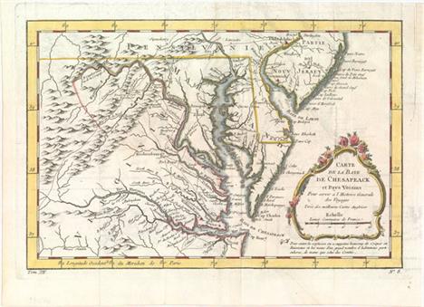
Carte de la Baye de Chesapeack et Pays Voisins pour Servir a l`Histoire Generale des Voyages Finely engraved colonial map covering most of Virginia, Maryland, Delaware with a bit of Pennsylvania and New Jersey. The interior is fully engraved with mountains and great detail along the rivers. An early network of trails and wagon roads are delineated, plus watershed and some topographical information. It extends west to beyond Fort Cumberland and locates Annapolis, Fredericksburg, Williamsburg, Norfolk, and Philadelphia. The delicate rococo-style title cartouche incorporates the distance scale. Issued folding on watermarked paper with light offsetting, a closed edge tear confined to the lower blank margin, and a binding trim at upper right replaced with old paper. 7.5"" W x 11.5"" H Bellin, Jacques Nicolas 1757

A Map of That Part of America Where a Degree of Latitude Was Measured for the Royal Society: by Cha. Mason, & Jere. Dixon This interesting little map covers the Delaware peninsula north to Philadelphia with only a few cities including Annapolis, Baltimore, and Greenwich. It locates many early settlements and shows the roads that connect them. The focus of the map is the initial measurements made by Charles Mason & Jeremiah Dixon for what has become known as the Mason-Dixon Line. These two British astronomers were employed to make this survey in order to resolve a long-standing dispute between the Calvert family, proprietors of Maryland, and the Penn family of Pennsylvania. This map, one of the first to show the results of the Mason- Dixon survey, shows this initial degree of latitude set into the context of the lands around the Chesapeake and Delaware Bays. The map is a slight variant of a map that appeared the previous year in The Philosophical Transactions of the Royal Society of London, reflecting the general public interest in this border dispute in the American colonies. Included with the lot is the complete disbound December 1769 issue of Gentleman`s Magazine. There is faint offsetting from an opposing page of text, else fine. The magazine has light scattered foxing and the first few pages are detached. 6.6"" W x 3.9"" H Anon., 1769

A Map of the Country round Philadelphia Including Part of New Jersey New York Staten Island & Long Island This Revolutionary War period map encompasses the area of Eastern Pennsylvania through Long Island and south to include Chesapeake Bay. The map was issued to illustrate the British Army`s objective of defeating Gen. Washington at Long Island and then to march to Philadelphia and put a quick end to the conflict. It is centered on Philadelphia, includes most of New Jersey, Delaware, Long Island, southwest Pennsylvania, northern Chesapeake Bay and the greater New York City area. The southern New Jersey coast is labeled Sandy Barren Desarts. The map is filled with interesting features including Indian villages, towns and cities, ferries, and roads (including the distances between towns). Adorned with a simple compass rose. Issued folding with light toning and soiling. There is minor show-through of manuscript ink on verso. 7"" W x 8.5"" H Anon., 1776

A Chart of Delaware Bay and River, from the Original by Mr. Fisher of Philadelphia. 1776. This Revolutionary War map was based on the chart Joshua Fisher made of Delaware Bay in 1756 and expanded upon in 1776. The Fisher map was the most important map of the bay and river in the eighteenth century. This map was derived from the 1776 edition, and was published with an article updating the British public on the war in the colonies. It shows the bay and beyond to Philadelphia and is filled with place names and the location of many hazards to navigation along the waterway. Locates Cape May, Turtle Gut Inlet, Cape James, Egg Island, Salem, and much more. Two distance scales and the direction rose with fleur-de-lis orients north to the right. Published in the July, 1779 issue of the Gentleman`s Magazine. Issued folding with faint offsetting. 7.2"" W x 9.2"" H Anon., 1779
![[Lot of 2] A New Map of Virginia with Its Canals, Roads & Distances from Place to Place Along the Stage & Steam Boat](http://lot-images.atgmedia.com/SR/36385/2916721/158-2014116143526_468x382.jpg)
[Lot of 2] A New Map of Virginia with Its Canals, Roads & Distances from Place to Place Along the Stage & Steam Boat Routes [and] A New Map of Maryland and Delaware with Their Canals, Roads & Distances A. A New Map of Virginia with Its Canals, Roads & Distances from Place to Place Along the Stage & Steam Boat Routes. An attractive map with nice detail of the counties, cities, roads and railroads. At top is a profile of the Chesapeake & Ohio Canal. A table at bottom lists Steam Boat Routes - Richmond to Norfolk, Richmond to Washington, Richmond to Baltimore, Wheeling to Pittsburgh, and Wheeling to Cincinnati. B. A New Map of Maryland and Delaware with Their Canals, Roads & Distances. Fine map with good detail of the counties, cities, roads and railways. Table at top lists Steam Boat Routes - Baltimore to Norfolk, Baltimore to Philadelphia and Baltimore to Washington. A large inset depicts the city of Baltimore divided into wards with a numbered index to important buildings. Original color with minor soiling, a few small brown spots in the image, and light toning along edges of sheets. 11.3"" W x 14.1"" H Tanner, Henry Schenck 1844
![[Lot of 3] A New Map of Maryland and Delaware with Their Canals, Roads & Distances [and] Colton`s Delaware and Maryland](http://lot-images.atgmedia.com/SR/36385/2916721/159-2014116143528_468x382.jpg)
[Lot of 3] A New Map of Maryland and Delaware with Their Canals, Roads & Distances [and] Colton`s Delaware and Maryland [and] Colton`s City of Baltimore Maryland A. A New Map of Maryland and Delaware with Their Canals, Roads & Distances, by Thomas, Cowperthwait & Co., dated 1850 (14.7 x 11.5""). Attractive map with nice detail of the counties, cities, roads and railways. Table at top lists Steam Boat Routes - Baltimore to Norfolk, Baltimore to Philadelphia and Baltimore to Washington. An inset table lists the population according to the census of 1850 compared with earlier periods. Condition: Light toning confined to the sheet edges. (A) B. Colton`s Delaware and Maryland, by G.W. & C.B. Colton & Co., dated 1855 (16.5 x 13.0""). Detailed state and county map with railroads, roads, canals, cites and villages. Inset of the District of Columbia identifies 12 locations on the grid plan. Surrounded by a scroll border. Condition: Minor soiling along the top portion of the map image and light toning confined to the sheet edges. (B+) C. Colton`s City of Baltimore Maryland, by G.W. & C.B. Colton & Co., dated 1855 (16.0 x 13.0""). Detailed map of the city`s grid, divided into 20 wards. Identifies Patterson Park, Baltimore Cemetery, the Parade Ground and Fort McHenry. Surrounded by a scroll border. Condition: Light toning confined to the sheet edges. (A) See description See description 1850-55
![[Lot of 5 - Coal Fields Maps] This rare set of maps of the coal fields are the companions to the oil maps presented in Sweet](http://lot-images.atgmedia.com/SR/36385/2916721/160-2014116143531_468x382.jpg)
[Lot of 5 - Coal Fields Maps] This rare set of maps of the coal fields are the companions to the oil maps presented in Sweet`s elusive report on the oil regions of Pennsylvania and West Virginia. Each map is folding, printed in blue ink with light brown overprinting to indicate coal reserves. Each is highly detailed showing coal deposits and the transportation network of roads, railroads and canals. The lot includes the following:A. Map of Pennsylvania Shewing Routes by Railroad & Water from the Coal Fields (30.3 x 20.9""). Includes part of New York, New Jersey and Maryland. Extensive portion of western Pennsylvania indicates coal reserves. B. Map of Middle Coal Basin Compiled from the Latest Reliable Sources (28.6 x 15.1""). Extremely detailed on a scale of approximately 1.75 miles per inch, this map is centered on Mount Carmel showing much of the region covered with coal. The larger towns located are Bloomburg, Northcumberland, and Pottsville. C. Map of Southern or Schuylkil Coal Basin (28.5 x 16.9""). The detailed map is centered on Pottsville and names North Lebanon, Sunbury and Hamburg. D. Map of the Wyoming & Lackawanna Coal Basin (15.9 x 16.6""). The map is roughly centered on Pittston and names Wilkesbarre, Tuckhannock, Providence and Carbondale. E. Cumberland Coal Region Shewing the Relative Positions of the Mines (22.0 x 8.3""). This coal mining map shows Maryland and northern Virginia. The map has two panels: the first shows the Piedmont area at the confluence of the North Branch of the Potomac River and Georges Creek. The right panel depicts the various coal holdings along Georges Creek near Dans Mountain. Both name property owners, roads, topography, and railroads. Issued folding with an occasional spot of foxing and light toning along a few folds and the edges of the sheets. The map of the Schuylkill coal basin has a red ink smudge in the image. See description Sweet, S.H. 1865

Virginiae Partis Australis, et Floridae Partis Orientalis, Interjacentiumque Regionum Nova Descriptio This striking map of the Southeast shows the French and English claims in the region marked with their respective coats of arms. The cartography in the southern part of the map retains Le Moyne`s three imaginary lakes, the largest draining through the Carolinas via the May River. While the map is nearly identical to the Blaeu/Jansson model on which it is based, the decorations are entirely original. The title cartouche is engraved onto a buffalo hide displayed by two Native Americans and at top is a large view that illustrates a group of natives panning for gold.See also lot 764 for Cumming`s excellent reference work, which describes this map. A fine impression with attractive color on watermarked paper. There is a minor printer`s crease adjacent to centerfold at top, and a hint of toning along centerfold. 11.4"" W x 13.8"" H Montanus, Arnoldus 1671

Carte de la Caroline et Georgie pour Servir a l`Hist. des Etablissemens Europeens This is the Dutch edition of Bellin`s delicately engraved map of the colonies of Carolina and Georgia from Albemarle Sound to the Alatamaha River. It probably owes its origin to the 1752 map of the region by Emanuel Bowen. There are numerous English settlements along the coast and Indian villages are located throughout, including a number west of the Appalachian Mountains. There is more detail in the area west of the Blue Ridge than in many other maps of the period. It shows a rudimentary course of the Tennessee River in the northwestern section of the map. A decorative rococo-style title cartouche incorporates the distance scale. Engraved by A. van Krevelt.See also lot 764 for Cumming`s excellent reference work, which describes this map. A nice impression with a few damp stains and tiny spots of color offsetting. 7.4"" W x 11.3"" H Bellin, Jacques Nicolas 1773
![[Lot of 2] A New Map of Nth. Carolina with Its Canals, Roads & Distances from Place to Place, Along the Stage & Stea](http://lot-images.atgmedia.com/SR/36385/2916721/166-2014116143541_468x382.jpg)
[Lot of 2] A New Map of Nth. Carolina with Its Canals, Roads & Distances from Place to Place, Along the Stage & Steam Boat Routes [and] A New Map of South Carolina with Its Canals, Roads & Distances from Place to Place Along the Stage & Steam Boat Routes This fine pair of early maps depict counties, roads, railroads, canals and settlements. Tables at top and bottom display the distances along various steamboat routes to and from New Bern, Elizabeth City, Charleston and Savannah. Insets include the Gold Region to the north and east of Charlotte, the vicinity of New Bern, and Charleston. Above the North Carolina map is a profile of the Dismal Swamp Canal. Published by Carey & Hart in Philadelphia. Original color with a few spots in the image and light toning along sheet edges. 11.3"" W x 13.9"" H Tanner, Henry Schenck 1841

La Floride, Suivant les Nouvelles Observations This handsome map of the southern United States was based on Delisle`s influential Carte du Mexique de la Floride of 1703. The map details early colonial settlements and Indian tribes. The large lake first found on Le Moyne`s 1591 map is here called Lac Grande and it is land-locked. The Mississippi River is shown too far west of its true course and the Apalachicoli River flows from a large spurious lake in present-day Tennessee. Details of part of the Bahamas are included. The Gulf of Mexico is filled with a large cartouche featuring Native Americas and an incongruent lion.See also lot 764 for Cumming`s excellent reference work, which describes this map. A dark impression with moderate toning with a few spots of foxing. 10.3"" W x 15.2"" H Aa, Pieter van der 1714

La Floride This influential map shows the Spanish and French possessions in the southern part of the United States. The map extends from the southernmost part of Virginia to the coast of what is now Texas. When first introduced by Sanson in 1657, this map was the first to use the name L. Erie in an atlas and to introduce several new rivers in Virginia. The French claims in the Carolinas are reasserted with the region named Floride Francoise, despite the region not having had any French presence for nearly 100 years. The place name Caroline is not related to the future English colony of Carolina. Instead it is a confusion between the French Fort Caroline on the St. Johns River, and Charlefort that was located near Port Royal. According to Burden, this is the fifth state of the map with plate number 261 at upper right.See also lot 764 for Cumming`s excellent reference work, which describes this map. An attractive example with a hint of toning and light soiling confined to the blank margins. Remnants of paper tape on verso along the top edge of the sheet. 6.9"" W x 9.9"" H Sanson, Nicolas 1738

North America Sheet XIII Parts of Louisiana, Arkansas, Mississippi, Alabama & Florida This detailed steel engraved map consists of primarily Louisiana and Mississippi. The map delineates counties and towns, churches, lakes, post offices and courthouses. County development in Louisiana is only along the river and in Mississippi it is limited to the southern portion of the state as a large portion of Mississippi is Chocktaw country. Keyboard style border. Small creases in top and bottom blank margins. 12.3"" W x 16"" H SDUK Society for the Diffusion of Useful Knowledge, 1833

North America Sheet XII Georgia with Parts of North & South Carolina, Tennessee, Alabama & Florida Steel engraved map that covers all of Georgia and extends west into Alabama to just beyond Montgomery. Also includes the western portions of North and South Carolina, and a large portion of Tennessee. Details county development, roads, watershed and terrain. Keyboard style border. Original outline color with light toning. Trimmed at top with some loss of title and close to the neatline at bottom, as issued. 15.7"" W x 12.5"" H SDUK Society for the Diffusion of Useful Knowledge, 1840
![[Lot of 2] A New Map of Louisiana with Its Canals, Roads & Distances from Place to Place, Along the Stage & Steam Bo](http://lot-images.atgmedia.com/SR/36385/2916721/173-2014116143554_468x382.jpg)
[Lot of 2] A New Map of Louisiana with Its Canals, Roads & Distances from Place to Place, Along the Stage & Steam Boat Routes [and] A New Map of Arkansas with Its Canals, Roads & Distances A. A New Map of Louisiana with Its Canals, Roads & Distances from Place to Place, Along the Stage & Steam Boat Routes, dated 1839 (14.2 x 11.4""). Attractive state map showing early county configurations with good detail of cities, towns, roads, canals and railroads. Features a large inset of New Orleans with a key to important buildings. Tables at left display the distances along various steamboat routes to and from New Orleans. B. A New Map of Arkansas with Its Canals, Roads & Distances, dated 1841 (11.4 x 14.3""). Fine map showing early county configurations with good detail of cities, towns, roads, canals and railroads. County configuration is up to date as of 1840 with Bradley formed from Union and Yell from Pope, Scott and Hot Springs. A table at top displays the distances along various steamboat routes to and from Little Rock. Original color with light soiling and toning along edges of sheet. See description Tanner, Henry Schenck 1839-41
![[Lot of 2] A New Map of Tennessee with its Roads and Distances from Place to Place Along the Stages & Steam Boat Routes](http://lot-images.atgmedia.com/SR/36385/2916721/174-2014116143556_468x382.jpg)
[Lot of 2] A New Map of Tennessee with its Roads and Distances from Place to Place Along the Stages & Steam Boat Routes [and] A New Map of Kentucky with its Roads & Distances from Place to Place Along the Stage & Steam Boat Routes A. A New Map of Tennessee with its Roads and Distances from Place to Place Along the Stages & Steam Boat Routes, dated 1841 (14.4 x 10.5""). This is the uncommon Tanner issue of this map; one of the few 19th century maps to show Tennessee alone. The map is inset with the regions surrounding both Nashville and Knoxville at the top, and the steamboat routes all the way to New Orleans are noted in a table to the right. Samuel Augustus Mitchell, and then Thomas, Cowperthwait & Co. purchased the plates for their editions of the Universal Atlas, but it is the earlier Tanner editions that are much more sought after. B. A New Map of Kentucky with its Roads & Distances from Place to Place Along the Stage & Steam Boat Routes, dated 1839 (13.0 x 10.7""). This highly detailed map of Kentucky illustrates roads and distances along the stage and steamboat routes. Canals, railroads, the state capital, county towns and leading roads are noted. Includes insets of Falls of Ohio, the vicinity of Clarksburg and Maysville, and the vicinity of Lexington. This is one of a few 19th century maps to show Kentucky without Tennessee. Original color with a few minor spots in the image and light toning along sheet edges. See description Tanner, Henry Schenck 1839-41

Carte de la Floride, de la Louisiane, et Pays Voisins... Superb small map based on Delisle`s map of the French colony of Louisiana. This finely engraved and detailed map of French Louisiana extends from the Great Lakes to the Gulf of Mexico and from Nouveau Mexique to Florida (not showing the tip of Florida). Many Indian place names, forts and early European settlements are shown. Nouveau Mexique in the far west includes Santa Fe and names the S. Jerome de Taos. The decorative title cartouche includes the distance scale. Issued folding on a clean watermarked sheet with faint offsetting and a binding trim at upper right that has been replaced with old paper. 8.8"" W x 12"" H Bellin, Jacques Nicolas 1757

Countries Bordering on the Mississippi and Missouri This rarity is an early map detailing the heart of the United States, from the region of present-day North Dakota to Lake Erie in the north, and from San Antonio to the Georgia and Florida coast in the south. The boundaries and internal political divisions of Arkansas and Missouri are unique to this map. Their western boundary is defined by the ""Osage Boundary"" shown at 94°W longitude. Arkansas contains two districts, namely Arkansas and Lawrence, and Missouri contains Cape Girardeau, St. Louis and Howard districts. To the west is an immense Missouri Territory which in turn incorporates a large but ill-defined Dewalieierres Grant with no mention of Texas or Cenis. Chicago is on the shore of Lake Michigan in Illinois Territory, but is shown many miles south of its correct position. The ""Extended [Indian] Boundary by various Treaties"" wanders through Indiana and Ohio and is loosely associated with the north-south Osage Boundary. In the area of Texas, the outward and homeward routes for Pike`s expedition are delineated, many forts are named, and the Haywa Wanderings and the Haytones Wandering Grounds are located. Early wagon roads and trails noted, as are early towns and cities as far north as Cleveland. Imprint below neatline ""Published Jany. 15, 1821 by Sir Richd. Phillips & Co. London."" The map is bound it the original ""Journal of a Tour into the Interior of Missouri and Arkansas, from Potosi, or Mine a Burton, in Missouri Territory, in a South-West Direction, toward the Rocky Mountains; Performed in the years 1818 and 1819"" by Henry R. Schoolcraft, Printed for Sir Richard Phillips and Co., London. This is Schoolcraft`s log detailing his remarkable 90-day expedition. Without covers, 102 pp, large folding engraved map present. Also includes 26 pp. of text at the end entitled ""Voyage from France to Cochin-China."" The map has faint offsetting, minor soiling, and a 3"" binding tear closed on verso with old paper. Disbound text is mostly clean with about half of the pages dog-eared in the bottom corner. 12"" W x 14.5"" H Schoolcraft, H. 1821
![[Lot of 3] Map of the States of Mississippi, Louisiana, and the Arkansas Territory [and] Map Illustrating the Plan of the De](http://lot-images.atgmedia.com/SR/36385/2916721/177-201411614361_468x382.jpg)
[Lot of 3] Map of the States of Mississippi, Louisiana, and the Arkansas Territory [and] Map Illustrating the Plan of the Defences of the Western & North-Western Frontier... [and] U. States` Indian Frontier in 1840... A. Map of the States of Mississippi, Louisiana, and the Arkansas Territory, by John Hinton, dated 1832, black & white (10.5 x 16.1""). A very detailed map showing Indian tribes, parishes, rivers, forts and roads. The map extends to the Sabine River with Mexico to the west. Arkansas Territory, with early county development, is included. The Mississippi Delta area is especially well-rendered, graphically depicting the swamps. Topography is shown via bold hachure and swamps and wetlands are depicted with shading. Condition: Issued folding with light offsetting and toning, as well as binding trims at the top and bottom right corners of the sheet. (B+) B. Map Illustrating the Plan of the Defences of the Western & North-Western Frontier..., by Charles Gratiot, from Sen Doc. 65, 25th Congress, 2nd Session, circa 1838, hand color (15.3 x 21.6""). This map is from the series of maps that illustrated the factious Congressional debate over the nature of the frontier defenses in the region between the Mississippi River and the Rocky Mountains. Issued under the direction of Col. J. J. Abert by W. Hood, the map depicts the states of Missouri, Arkansas, Louisiana and the Indian nations bordering them to the west. It shows the locations of many military forts and outposts from Ft. Jessup to Ft. Snelling with notations throughout concerning lands ceded by several Indian nations with the dates of the treaties. The threat posed by hostile Indians, whose numbers greatly exceeded those of the area`s settlers, resulted in a protracted Congressional debate concerning the defenses required along the frontier. A table at lower left notes the distances between forts and the equivalent ""days of march"" at 15 miles per day. Ref: Wheat (TMW) #427; Claussen & Friis #183. Condition: Issued folding with some minor foxing primarily along one fold and in the upper blank margin. (B+) C. U. States` Indian Frontier in 1840, Shewing the Positions of the Tribes That Have Been Removed West of the Missisippi, by George Catlin, circa 1876, printed color (5.4 x 8.6""). Shows the location of over twenty Indian tribes from present-day Oklahoma to Iowa that were displaced by western expansion. Condition: (A) See description See description 1832-76

Traveller`s Guide. A Map of the Ohio and Mississippi Rivers. Extending from Pittsburgh to the Gulf of Mexico This guide was printed for the use of travelers during the golden age of steamboats. Two strip maps are laid parallel to each other - one from Pittsburgh to Cairo, and the other from New Madrid to the mouth of the Gulf of Mexico. Contains an extensive mileage index on the left side of the map. Printed on yellow paper which folds into its original marbled hard covers. The inside front cover contains the signature of George Lafong, a native Virginian who went to Ohio in his early 40s and lived to be 88. Created by Joseph Duff and published by George Conclin. The map has light soiling and a few short splits at fold intersections that have been closed on verso with archival tape. Spine on hard covers has been reinforced with archival tape. 22.6"" W x 8.3"" H 1845

Geological Map of the Middle and Western States This colorful lithographed geological map, produced by the eminent American geologist James Hall, blends science and the art of cartography. Twenty-three geological types are named and differentiated using hand applied color. The map covers the region of the United States from its western boundary along the Mississippi River, east to Long Island and the Atlantic. It includes all or parts of Wisconsin, Illinois, Missouri, Kentucky, Virginia, Indiana, Ohio, Michigan, Pennsylvania, New York, New Jersey, Maryland, and Delaware. The lakes Michigan, Huron, Erie and Ontario are shown. Lithographed by Endicott of New York and signed in the plate by James Hall. A very nice example of an early and scarce geological map. Blank verso.This important regional geological map employs the ""New York System"" of stratigraphic nomenclature developed by Hall and others at the New York Geological Survey. This system emphasized the importance of paleontology for delineating geological units and introduced the concept of ""type locality,"" a primary reference location used for defining the characteristics of geological formations. This map is the first regional application of this new system, which evolved into the standard nomenclature used today for North America and much of the rest of the world. Issued folding with bold color and light toning at top and in the upper right corner where the map folds into the report. Narrow right side margin, as issued. 23"" W x 32"" H Hall, James 1843

Upper Territories of the United States This map depicts the old Northwest Territory showing the state of Ohio along with Indiana, Illinois, Michigan and Northwestern Territory. Indiana would achieve statehood later in the publication year. Detroit is shown with its Canadian neighbor, Windsor, named Sandwich, but there is no Chicago. Several frontier forts are located, but much of the territory still appears unsettled. The apocryphal mountain ridges are the most prominent topography on the map and the fictitious Phillipeaux Island remains in Lake Superior. Engraved by H.S. Tanner. Original color with light soiling and a few edge tears closed on verso with archival tape. 10.8"" W x 8.5"" H Lucas, Fielding 1816

North America Sheet V The North West and Michigan Territories This is an interesting map of most of the Northwest Territory and Michigan Territory. It has the elongated Lake Michigan and bears some resemblance to Burr`s map of 1831. The Ottawa and Miami Indian nations are shown occupying the whole northern part of Michigan and the only settlement in the North West Territory is Green Bay Township along with Fort Howard. Minor soiling and a few small creases confined to the blank margins. 12.3"" W x 15.3"" H SDUK Society for the Diffusion of Useful Knowledge, 1833

Wisconsin and Iowa According to Rumsey, this map comes from a rare 1848 reissue of Greenleafs 1842 Universal Atlas. By this time, the southern portion of Iowa Territory had become the state of Iowa, although there is no engraved northern border to indicate this fact and the area is essentially still one large territory. County development is confined along the Mississippi River and Lake Michigan. Outside of the developed areas, numerous Indian tribes are located and the river system is depicted in good detail. Minor toning along sheet edges, else fine. 10.3"" W x 13.1"" H Greenleaf, Jeremiah 1848
![[Lot of 2] A New Map of Indiana with Its Roads & Distances [and] A New Map of Illinois with Its Proposed Canals, Roads &](http://lot-images.atgmedia.com/SR/36385/2916721/184-2014116143613_468x382.jpg)
[Lot of 2] A New Map of Indiana with Its Roads & Distances [and] A New Map of Illinois with Its Proposed Canals, Roads & Distances from Place to Place Along the Stage & Steam Boat Routes This fine pair of early maps depict counties, roads, railroads, canals and settlements. The National Road is shown crossing through both states from Indianapolis to Terre Haute and St. Louis. Tables at both left and right display the distances along various steamboat routes to and from Louisville and St. Louis. An inset at the bottom of the Illinois map displays the lead region of northwestern Illinois and southern Wisconsin and identifies smelting furnaces, lead ore and copper mines. Published by Carey & Hart in Philadelphia. Size varies slightly. Original color with light soiling. 13.8"" W x 11.3"" H Tanner, Henry Schenck 1841
-
109198 item(s)/page