We found 109182 price guide item(s) matching your search

Refine your search

Year

Filter by Price Range
  • List
  • Grid
  • 109182 item(s)
    /page

Lot 61

BLOME RICHARD. A Mapp of the Kingdome of Scotland. Hand col. eng. map. 14½" x 16", in hogarth frame.

Lot 62

PONT T. & BLAEU J. Evia et Escia ... Eusdail et Eskdale. Antique hand col. eng. map. 17" x 21", in hogarth frame, showing Latin text to reverse.

Lot 63

PONT T. Nithia Vicecomitatus, The Shirifdom of Nidis-Dale (Nithsdale). Antique hand col. eng. map. 16" x 21½", in hogarth frame, showing Dutch text to reverse.

Lot 64

PONT T. Lidalia ... Lidisdail. Antique hand col. eng. map. 17" x 21", in hogarth frame.

Lot 65

SPEED JOHN. The Kingdome of Scotland. Antique hand col. eng. map, vignettes of the Royal Family, Orkney in the corner panel. 15" x 20", in hogarth frame. 1610.

Lot 66

GORDON R. Scotia Antiqua. Antique hand col. eng. map of Scotland with Orkney & Shetland in the right hand panel. 16½" x 21½", in hogarth frame. 1653.

Lot 67

PONT T. & BLAEU J. Annandiae ... the Stewartrie of Annandale. Antique hand col. eng. map. 17" x 20", in hogarth frame, showing Latin text to reverse.

Lot 70

SMITH C. New & Accurate Map of the Lakes in the Counties of Cumberland, Westmorland & Lancaster. Antique hand col. eng. map. 24" x 19½", unframed. 1800.

Lot 71

SMITH C. A New Map of the County of Cumberland. Antique hand col. eng. map. 20" x 18", unframed. 1801; also a small bundle of other maps incl. a survey of the road from Stilton to Flamborough Head.

Lot 79

KIPLING R. The Absent-Minded Beggar. Printed cloth, 18" x 16" with vignettes of Lord Roberts & Queen Victoria, map of South Africa, the poem & music by Arthur Sullivan, c.1900.

Lot 7

Captain Greenvile Collins (1643-1694) British. "The East Coast of Scotland, with the Isles of Orkney and Shetland", Map, 17.5" x 22".

Lot 183

John Speed (c. 1551-1629):A map of Middlesex, hand coloured engraving, H 39 x W 51 cm

Lot 184

John Speed (c. 1551-1629):A map of Hertfordshire, hand coloured engraving, H 39 x W 51 cm

Lot 325A

A framed Map of Derbyshire, hand coloured , produced from the Survey by C and I Greenwood 1824-25, coloured vignette of Chatsworth House to corner

Lot 310

An assortment of mixed collectables including a Kodak no. A116, colour filter and tripod, together with a pair of cased opera glasses, an ordinance map, a set of six silver-plated butter knives and six forks and a heavy bronzed nutcracker, modelled as a dog etc.

Lot 493

A Robert Morden hand coloured printed map, late 17th century, The West Riding of Yorkshire, approximately 40cm x 35cm

Lot 495

After Robert Morden. Map of Cumberland, later coloured, 37cm x 42cm

Lot 496

After Robert Morden. Map of Norfolk, later coloured, 48cm x 59cm

Lot 504

Possibly Gerardus Mercator. An early 17thC hand coloured map of the Eastern Counties, 36.5cm x 42.5cm

Lot 505

After John Speed. A map of Flintshire, later painted (AF), 39cm x 41cm

Lot 506

After Joannes Jansson. A 17thC hand coloured map of Lincolnshire, glazed to both sides, 42cm x 53cm

Lot 507

After Saxon Kipp. An early 17thC map of Lincolnshire, uncoloured, 31cm x 36cm

Lot 508

After John Speed. A 17thC hand coloured map of Lincolnshire, glazed to both sides, 42cm x 53cm

Lot 529

After Robert Morden. Map of Lincolnshire, coloured print, 36cm x 42cm

Lot 530

After Emmanuel Bowen. Accurate map of Lincolnshire, divided into its Wapentakes, coloured print, 75cm x 55cm, unframed and an unframed Crome print (2)

Lot 534

A Victorian hand coloured photograph, depicting a man wearing a cap, oval, 19cm x 16cm, in contemporary frame and a linen backed map of England and Wales

Lot 752

A quantity of ephemera, etc, to include cigarette cards from the Gallaghers Famous Footballers series, Royal memorabilia, WWI silk postcards, and a Grand Southern Tour map of England, engraved printed and sold by John Hebner.

Lot 230

A 19th century hand coloured map of Paris, printed by J Goujon, 1824, linen backed.

Lot 464

Saxton map of Cumberland

Lot 258

JOHN OGILBY, a late 17th Century road map (London to Holy Head), Lichfield to Chester, later hand coloured, 32cm x 44.5cm

Lot 521

SIX BOXES BOOKS, MAGAZINES, MAP ETC, to include Photography, Royalty, War etc

Lot 544

A BOX OF PENGUIN PAPERBACKS, a wicker cradle, a quantity of 78's and late 19th Century map of Staffordshire (two boxes and cradle)

Lot 285

A VICTORIAN FRUITWOOD AND CLOTH TAPE MEASURE, a silk map of England and Wales, a white metal backed hair brush and other items (one box)

Lot 433

ROBERT MORDEN'S MAP OF DORSETSHIRE (unframed) and a collection of maps and printed ephemera

Lot 684

Yeats (Jack B.). A sheet of plain Cardboard, 17 ins x 14 ins, bearing a manuscript contents list in Jack's hand for a large chest in which Jack kept his loose paintings, prints, drawings, sketchbooks, as well as maps and charts, Japanese prints, photographs, his address book and so on, in seven numbered drawers (the numbers in colours to right).* A fascinating list, enough to whet the appetite of any collector. Alas, the contents have by now been spread to the four winds, apart from a few to be found in this sale.Preserved within a folded map of Ardbear Bay, Galway, titled in Jack's hand.Provenance: The Yeats Family Collection.

Lot 1387

Four small Indian polychrome painted wooden figures of animals, 19th century, 2 - 3cm high, a copper and iron handled chocolate pot, a map printing block and other items (qty).

Lot 368

Maps - (1) Cary's New Map of England and Wales with part of Scotland published by J Cary June 11 1794 (incomplete, the following sheets are present 5-11, 18-20, 27-29, 31, 37-39, 42-46, 49, 52-55, 60, 61, 63, 64, 70, 73,77-79 and 81) the dedication page has a holograph inscription Capt Manners Sutton Coldsm Guards 1804 (2) The Traveller's Guide Through England, Wales and Principal part of Scotland with all the Railways & Turnpike Roads to 1850, Darton & Co, Holborn Hill printed on linen (3) Bacon's Reversible Map of Kent and Sussex (4) One sheet (Part of Suffolk) from A Map of the Country Sixty Five Miles Round London from actual surveys by John Andrews and Andrew Dury, published by John Stoke (51cm x 135cm)paper laid down on linen All maps in this Lot are sold as found

Lot 381

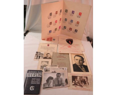
A specimen collection of eighteen interwar German stamps overstamped Ostland and franked Kauen 11.1.1942, and loose German franked and unfranked stamps of the same period. Also ephemera including a message of thanks from Field Marshall B L Montgomery on leaving 21st Army Group, officer's release book, street map of Berlin, Certificate of Post War Credit post cards and photographs of service officers in Berlin

Lot 441

David N Robinson collection - Map of Lincolnshire by John Cary 1801 65 cm x 73 cm

Lot 605

Large set of map drawers

Lot 432

19th century map of Lincolnshire 54 cm x 58 cm

Lot 1338

An 18th century map, Waltham Hundred, together with a selection of further maps, prints, ephemera, etc.

Lot 1509

John SpeedeTHE NORTH AND EAST RIDINS OF YORKSHIREHand coloured map,41 x 52cm

Lot 303

A Collection of Various Coloured Etchings and Prints, Shropshire Map and Decorated Fan

Lot 331

Four vintage and modern wristwatches, including a mid sized or boys 9ct gold Avia, a 9ct gold Bueche-Girod, a lady's Balenciaga and another with a Myoto with Italian map dial, along with two watch boxes (6)

Lot 163

John Ogilby (1942-2004), 'The Road from Bristol to Weymouth', map engraving. H.34cm W.44cm

Lot 164

A William Kip map of Dorchester, engraving. H.27cm W.38cm

Lot 1161

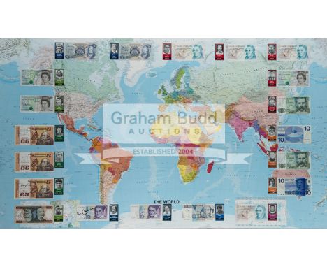
Signed Footballers of the World framed display,comprising a large scale map of the world applied with 20 banknotes each bearing the autograph of an international footballing legend and accompanied by a portrait card, comprising: Bank of England £5 notes signed by Geoff Hurst, Stanley Matthews, Bobby Charlton and Peter Shilton plus Northern Ireland's George Best & Pat Jennings, and Hungary's Ferenc Puskas; Bank of Scotland £5 notes signed by Kenny Dalglish & Denis Law; Central Bank of Ireland £5 notes signed by Frank Stapleton, Liam Brady & David O'Leary; a Banco Central do Brasil 1,000 Real note signed by Pele; Deutsche Bundesbank 10 Deutsche Mark notes signed by Franz Beckenbauer & Karl-Heinze Rummenigge; a Banca d'Italia 10,000 Lire note signed by Dino Zoff; Nederlandsche Bank 10 Guilders notes signed by Johan Cruyff & Ruud Gullit; and Banco de Espana 1,000 pesetas notes signed by Denmark's Michael Laudrup (Real Madrid & Barcelona) & Holland's Ronald Koeman (Barcelona), framed & glazed, 95 by 153cm.

Lot 555

A Japanese Government Railways tourism brochure printed before the cancellation of the 1940 Tokyo Olympic Games,English language, with mention of the Games including construction of venues and preparations in general, includes fold out map, paper damage bottom right-hand corner of brochure

Lot 601

Tokyo 1964 Olympic Games Official Report,Japanese language edition, 2 vols in a slip case, plus map of venues, extensive coverage and illustrations, in Japanese language, published by the Organizing Committee, this set is still with its original cardboard packaging

Lot 602

Tokyo 1964 Olympic Games Official Report,French language edition, 2 vols in a slip case, plus map of venues, extensive coverage and illustrations, published by the Organizing Committee

Lot 603

Tokyo 1964 Olympic Games Official Report,English language edition, 2 vols in a slip case, plus map of venues, extensive coverage and illustrations, published by the Organizing Committee

Lot 147

A copper etched map replica of Lancashire Pallatine 1610 with Lancaster inset

Lot 245

An English WWII Silk Map 'Zones of France' dated March 44

Lot 394

JOHN SPEED (1562-1629)Map of Ulster, from the rare Roger Rea edition of 1662Note: The majority of this edition was destroyed in the Great Fire of London

Lot 2086

A framed Pictorial Map of London

Lot 593

A Firestone Tyres Geographia road map of England and Wales, unusually an early tin version, 22 1/2 x 34".

Lot 1025

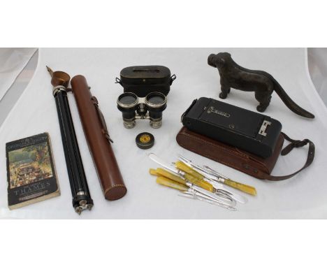
Lot of four books. Stoddart's Anglers Companion possibly rebound but front board loose still has original map. The Complete Book of the Dog by Robert Leighton dedication to inside page. Badminton Magazine XV 1902 pencil dedication front board coming away slightly, outer hard cover shows wear to spine ends and corners. Badminton Magazine Vol X 1900 internal repair to front board and a few loose pages.

Lot 908

17th century map of Stafford & Lichfield with alphabetical table of all the towns to the reverse in ebony & gilt frame, 56 x 45cm

Lot 993

Shropshire Union Railway 1845 - 5 x large joined planning/engineering sheets 51cm x 77cm titled 'Plan showing proposed line through Parish of Lilleshall'. Date appears to be 1845, together with a detailed relevant section of map dated 1833.

Loading...Loading...
  • 109182 item(s)
    /page

Recently Viewed Lots