We found 108737 price guide item(s) matching your search
There are 108737 lots that match your search criteria. Subscribe now to get instant access to the full price guide service.
Click here to subscribe- List
- Grid
-
108737 item(s)/page


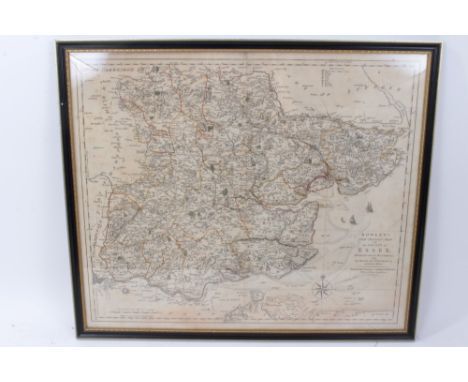
Lot 796
Carrington Bowles hand-coloured engraved map -‘New pocket map of the County of Essex, 49 x 54cm, glazed frame, together with John Ogilby hand coloured engraved road map - London to Yarmouth, Thomas Kitchin map of Suffolk, Mercator Hondius miniature map - ‘Essexiae Descriptio’ and Peter Andre ‘Plan of Colchester’. (5)


Lot 722
Giovanni Maria Cassini (18th century), hand-coloured map - ‘Le Indie Orientale’, dated 1797, 36cm x 49cm, together with another - ‘Le Isole Della Sonda, Moluccan, E Filippine’ (2).Condition report: Orientale - water stain from top edge, some general time staining Le Isole... - strengthened at spine, a small worm hole centrally, general time-staining

Lot 767
John William Norie (1722-1843), engraved map - ‘A new chart of The Straits of Malacca and Singapore’, published 1820, 62cm x 92cm.Condition report: Some staining particularly at periphery including water staining at lower edge and at folds, some tears at folds, some of which have been arrested with tape, no severe damage

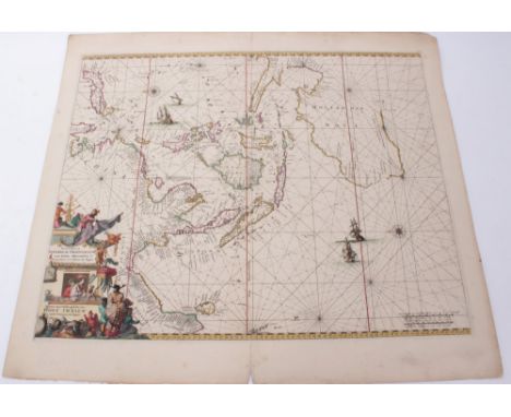
Lot 708
Jean Baptiste Nicolas Denis Apres de Mannevillette (1707-1780), hand-coloured chart - ‘A Chart of the East Indian Islands....’, dated 1778, printed for R. Sayer & J. Bennett, map and sea-chart sellers, No. 53 Fleet Street, 51cm x 89cmCondition report: Central fold, margins intact, a few stains and grubby areas but overall good condition

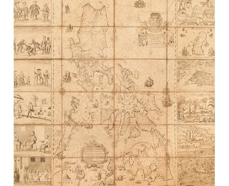
Lot 790
Pedro de Murillo Velarde (1696-1753), engraved map - ‘ Carta Hydrographica y Chorographica delas Yslas Filipinas Dedicada al Rey Nuestro Señor Por el Mariscal d Campo D. Fernando Valdes Tamon Cavallº del Orden de Santiago de Govor. y Capn. General de dichas Yslas‘, ( The Murillo Velarde Map), engraved by Nicolás de la Cruz Bagay, published Manilla 1734, title cartouche at the top with the Royal Bourbon coat of arms, supported by two cherubs with trumpets, the title on a cloth held by two female allegorical figures bearing charts and instruments for navigation. A further ornate cartouche below, surmounted by a crowned lion wielding a sword and a candle, contains a brief history of the archipelago starting with Magellan's arrival and death in 1521, a description of the resources: ‘These islands are numerous and rich: they have gold, wax, sugar, honey, tobacco, ginger, indigo, Brazil wood (sibucao), pitch, rice, salt, wheat, maize, lemons, oranges, bananas and many fruits and edible roots, palo Maria, tamarind, cassia-trees, Catbalogan seeds, dragon blood, lignum vitae, coconuts, bamboos, rattan and many kinds of palms, mahogany, tindalo and excellent timber for ships: horse, caraboas or buffaloes, cows, pigs, deer, chickens and much fish.’ There follows a description of the settlements, peoples, clergy and administration, all above an engraving of his ship the Victoria. The map is dissected and re-mounted on linen, 111cm x 120cm, early pen inscription verso - ‘map of the Philippine Islands’, folding map in later slip case. An extremely rare map and believed to be one of only around 15 extant examples of this first edition - the majority in International Institutions, and not all examples retain the flanking vignettes. Cited as the first scientific map of the Philippines and considered the most important Philippines map, it is celebrated for its detail and accuracy, it features shipping routes for trade with China and charts the course of Magellan’s navigations. The map features twelve flanking vignettes encapsulating the essence of the Philippines, depicting different ethnic groups, customs, flora and fauna, also featured are miniature maps of Guajan (Guam), Manila, Samboangan and Cavite , all extensively annotated. The map influenced all subsequent Philippine maps for decades to follow but its influence was also notable on European maps. In recent times The Murillo Velarde map has been instrumental in the Philippines' efforts to assert territorial rights in the South China Sea. The map, together with others was used by the Philippines' team of experts to refute China's historic claim of ownership of the entire South China Sea. It features ‘Panacot’ (Scarborough Shoal) as well as ‘Los Bajos de Paragua’ (Spratly Isles). In 2016 the Permanent Court of Arbitration ruled in favour of the Philippines stating that China had "no historical rights". China however, rejected the ruling. Provenance: Purchased from the map dealer Susanna Fisher, 1986 for £4,500. She had acquired the map from a trade source some years before and prior to that the map was believed to have been in private hands in the U.K. She states in correspondence that the ancient pen inscription in English to the reverse suggests that this map has been in the U.K. for a very long period of time,Condition report: Each corner has evidence of drawing pin holes with associated damage / slight losses, tear to the paper top left corner (prior to mounting on canvas), generally some staining towards periphery of each panel, particularly to central panels, and slight losses at margins of certain panels, conservation repairs and patching to canvas (patching at several of the folds) tonally the paper and ink is consistent throughout, some small tears at folds of canvas, generally some time staining and deterioration commensurate with age, no severe damages. Overall colour is yellowed somewhat but largely consistent throughout, some repair to canvas particularly at folds, detrioration to outer edges of each panel, staining to outer edges particulate to central two rows. Most of the maps is in good mostly original condition almost all of the printed element present, More specifically - Left row, top panel: damage and small losses top left corner, a tear runs diagonal from side upwards above printed element, stains at periphery, small tears at left side Left row, second panel: stains lower right, top right corner and lower edge, minor marks left row, third panel:small losses top left corner, minor deterioration upper edge, stains top right corner left row, fourth panel:some staining to corners, repair to canvas beyond lower right corner l;eft row, Fifth panel:slight loss top left corner, couple of fox masks, brown stain far right in map section, stain top right corner, small tear to canvas beyond lower right corner Left row, sixth panel: Some damage and small losses to printed element lower left corner, staining to left edge, Second row, top panel:stains left and right edges, canvas repair beyond top left corner, canvas tear beyond lower right corner, stains Second row, second panel: staining to corners, small tear to can vas beyond lower right corner Second row, third panel:staining to corners Second row, fourth panel: staining to corners, small tear beyond lower right corner, Second row, Fifth panel: staining and some slight deterioration to corners, small tear to canvas beyond lower right corner, Second row, sixth panel: some slight losses/deterioration lower right corner/ top right corner, brown staining around area of ship-Victoria Third row, top panel:some deterioration slight losses to corners, staining to corners, repair to canvas beyond lower right corner Third row, second panel:staining to corners, minor blemishes Third row, third panel: staining to corners, repair to canvas beyond lower right corner, Third row, fourth panel: minor stains lower right corner, repair to canvas beyond lower right corner Third row, Fifth panel: minor staining to periphery, repair to canvas beyond lower right corner, Third row, sixth panel:staining to left edge, top right corner, detrioration to lower left corner Right row, top panel: some small losses top right corner, bottom right corner, and deterioration lower edge, staining to periphery Right row, second panel: minor staining to right edge, minor blemishes, Right row, third panel:minor staining to right edge, Right row, fourth panel:staining to right edge, element here above the image top edge is a separate piece of paper and slightly misaligned, continues horizontally across the map, presume this is reflecting how the map was printed and presented before division and mounting rather than a replaced element. Right row, Fifth panel:staining right edge, slight losses lower right corner, repair to canvas beyond lower right corner, Right row, sixth panel: staining slight damage left edge, losses lower right corner, slight loss top left corner, blemishes


Lot 721
John Cary (c. 1754-1835), hand-coloured map - ‘A New Map of the East Indian Isles’, dated 1801, 49cm x 55cm, together with the 1811 edition of the same map and ‘A New Map of Asia’, 1806 (3).Condition report: 1801 map good 1811 map repairs to spine, creases and deterioration to margins New map of Asia 1806 - minor stains, basically good

Lot 604
Billingsley John, 'General View of the Agriculture of the County of Somerset in the year 1795', second edition, Bath 1798, half title, folding map frontis, one plat,e another folding map, marbled boards, half leather, rebacked, Kent Nathaniel ' General View of the Agriculture of the County of Norfolk...' printed at the Norfolk Press, 1796, folding map frontis, three plates, one folding, marbled boards, half leather, uniform with previous vol. [ John Holt ] 'General View of the Agriculture of the County of Lancaster ...' printed for G Nicol Pall Mall 1795, folding map frontis, folding and other plates, marbled boards, rebacked, Bailey J and Culley G ' General View of the Agriculture of the County Northumberland ...' London printed by B McMillan etc 1805, folding map frontis, plates some folding and including Cumberland and Westmorland , rebound, marbled boards, half leather, Home John ' Rectified Report of Berwickshire Agriculture...' Berwick published by and sold for the author 1797, folding coloured map, bound uniform with previous volume, Pitt W. ' General View of the Agriculture of the Country of Stafford...' printed for G Nicol Pall Mall 1796, plates folding map, folding plan, marbled boards, half leather and another vol (7)


Lot 702
John Speed (1552-1629), hand-coloured map - ‘Cambridgshire’, published Bassett and Chiswell, dated 1610, with armorial shields of the Colleges and vignette map of Cambridge, 39cm x 52cm, framedCondition report: Glazed frame and not examined out of frame, mounted to edge and no margins exposed, appears to be in good overall condition


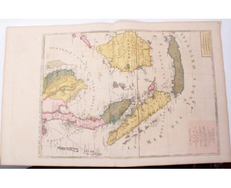
Lot 705
Herman Moll (d. 1732), hand-coloured map - ‘East Indies (Eastern half of the twin page map), 61cm x 50cm, framed.Condition report: Glazed frame, not examined out of the frame, framed to plate edge, several significant losses to periphery and coloured and inked replaced sections, patch repairs, some tears, creases, statins and general deterioration


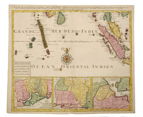
Lot 773
Joachim Ottens (17th / 18th century), set of three (of four) hand-coloured maps - ‘Partie de la Nouvelle Grande Carte des Indies Orientales’ ‘...Maldives, Ceylon, Malacca, Sumatra &c.’, ‘...Isles de Borneo, Java, Celebes, Mindanao’, 1725, 50cm x 60cm. (3)Condition report: Indies Orientales map with various tape repairs to margins, inset patch repair right of Sumatra, otherwise condition of these is generally good.


Lot 765
Jean Baptister Nolin (1657-1725), engraved map - ‘Les Royaumes qui luy font Tributaires, et les Isles de Sumatra, Andemaon, etc.’1687, 62cm x 46cm.Condition report: water/ink stain to top and lower edge of margins, browing to central fold and periphery, some creases, tape repairs and small tears to margin edges

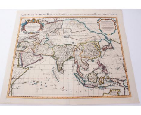
Lot 776
Nicolas Sanson (1600-1667), hand-coloured map - ‘L’Asie devisee en des Principales Parties Scavoir - La Turquie, En Asie, L’Arabie, La Peres, L’Inde, La Chine, La Tartarie, Les Isles Du Japan, Des Philippines, Des Molucques, Dela Sonde, De Ceylon et Des Maldives, 1674, 59cm x 87cmCondition report: Staining to periphery, image generally ok


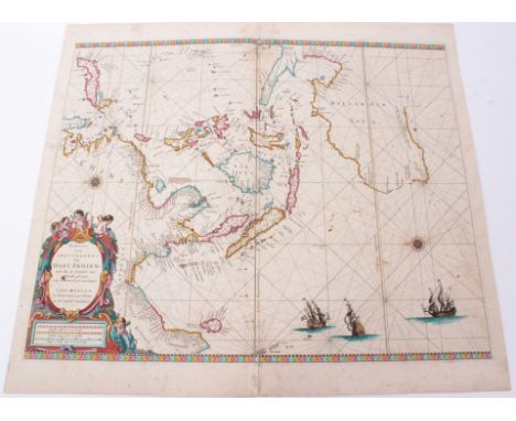
Lot 757
Pierre Mortier (1661-1711), hand-coloured map - ‘lLe Royaume de Siam auec les Royaumes qui luy font tributaries et les Isles de Sumatra Andemaon etc.’ 1700, 79cm x 56cm.Condition report: In two parts, joined, slightly misaligned, some transference of ink, minor stains, basically good condition


Lot 799
Local interest map: Norfolk, Kings Lynn - 'Plan of the Eau Brink River and part of the River Ouse with the proposed New Bridge, Public Roads and Drains communicating therewith 1819' - Hand drawn coloured plan by Charles Barcham of Kings Lynn, showing land ownership and field boundaries, inscribed in pen to rear ‘River Ouse - Proposed Eau Brink Cut’, 79 x 130cm NB: William Elstobb and others had suggested that the great bend in the river above King's Lynn should be removed by creating a cut, but it took 50 years of arguing before the Eau Brink Act was obtained in 1795 to authorise it, and another 26 years until the cut was finally opened in 1821. During this time, most of the major civil engineers of the time had contributed their opinions. The original project head and chief engineer was Sir Thomas Hyde Page. The work was overseen by John Rennie and Thomas Telford and construction took four years. It proved to be too narrow, resulting in further silting of the harbour and was widened at an additional cost of £33,000 on Telford's advice. It is believed that the only other copy of this plan can be found in The National Archives.


Lot 713
Guiljelmus Blaeu (1571-1638), hand-coloured map - ‘Asia Noviter Delineata’, 1630, with border vignettes of country types and scenes of ports, Dutch text verso, 38cm x 48cm.Condition report: spine has been strengthened and some tape repair, two central creases, a few small tears and creases to margins, water stain lower left corner, browning to periphery, some general creases, time stains and grubby marks but no severe condition issues


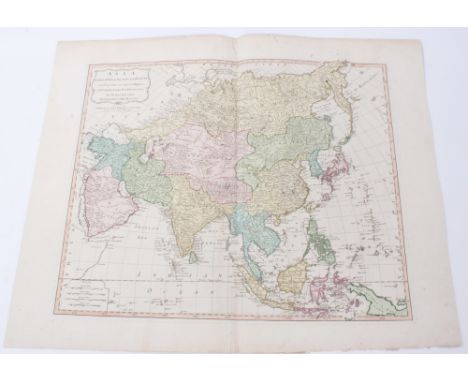
Lot 748
Thomas Kitchin (1718-1784), hand-coloured map - ‘Asia and its several Islands and Regions according to their most approved divisions, with Captain Cook’s New Discoveries, published Laurie & Whittle, London 1794, 45cm x 55cmCondition report: Patch repair to top of spine, some grubby marks and ink spots top right otherwise generally good


Lot 701
John Speed (1552-1629), hand-coloured map - ‘Suffolke’, sold by Bassett, circa 1610, with amorials of the Dukes and Earls of Clare and Suffolk, vignette map of Ipswich, 39cm x 52cm, in glazed frameCondition report: not examined out of the frame, mounted up to edge of image and no margins visible. However appears to be in good condition

Lot 700
John Speed (1552-1629), hand-coloured map - ‘Essex’, circa 1610, after John Nordon, sold by Bassett, with heraldic shields of the Earls of Essex and Colchester vignette map, 39cm x 52cm, in glazed frameCondition report: Glazed frame and not examined out of frame, mounted to edge and no margins exposed, slight deterioration bottom right corner, minor creases otherwise ok.


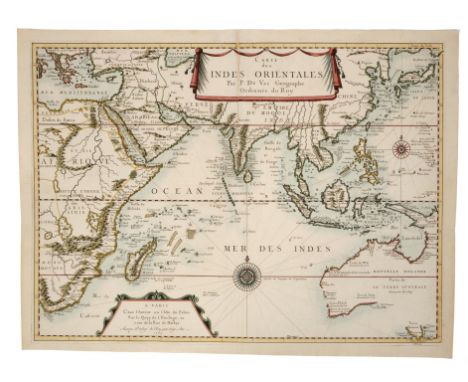
Lot 709
Pierre van der Aa (1659-1733), engraved map - ‘Les Indes Orientales’, 29cm x 34cm, 1714, together with eight further small Far Eastern maps by the same cartographer, several coloured, including ‘La Rade de Batavia’, ‘De Moluccos’, ‘L’Ile de Sumatra’, ‘Carte des Isles Phillippines Celebes et Moluques’, ‘Le Detroit de Malacca’, ‘ L’Ile de Borneo’, ‘Les Iles de Banda’, ‘Les Base de Manille’. (9)Condition report: minor disrepair, generally good order


-
108737 item(s)/page