We found 109182 price guide item(s) matching your search
There are 109182 lots that match your search criteria. Subscribe now to get instant access to the full price guide service.
Click here to subscribe- List
- Grid
-
109182 item(s)/page


Lot 645
An impressive large 19th Century Victorian antique pitch pine ships map / chart table or drapers table having a long flared table top with gallery backed edge. The table being raised on six block and turned legs with cylindrical stretchers and steel feet. The Steel feet with fixing holes for securing the table. Markings for VR to the underside in many places. Perfect for use as a kitchen refectory table. Measures; 62cm x 299cm x 64cm.


Lot 1
NO RESERVE Africa.- Park (Mungo) Travels in the Interior Districts of Africa: performed under the Direction and Patronage of the Africa Association, in the Years 1795, 1796, and 1797, portrait folding map, ownership inscription to title, contemporary calf, joints cracked, New York, by J. Tiebout, 1800 § Howel (William) An Institution of General History, or the History of the World, second edition, vol.1 & 3 only, for Henry Herringman, 19th century mottled calf, rubbed, upper cover detached to vol.1; and 33 others, travel, and duplicates of Thai language teaching book, v.s. (36)

Lot 10
Atlases.- Swanston (George H.) The Companion Atlas to the Gazetteer of the World, 48 hand-coloured engraved maps mounted on stubs, all but 3 (2 of South American coasts and Japan) double-page, those three with hand-coloured vignette illustrations in margins, title and list of maps foxed, maps with some foxing (particularly Japan), with large folding colour map of British territories from 'Illustrated London News' 1885 (spotted, tears to folds) and another of Albert Railway of New Brunswick both loosely inserted, contemporary marbled boards, rebacked and recornered in calf, spine decorated in black in compartments and green roan label, very slightly rubbed, folio (470 x 320mm.), Edinburgh, A.Fullarton & Co., [1860].

Lot 12
NO RESERVE Australia.- Baden-Powell (George) New Homes for the Old Country, map, plates and illustrations, hinges weak, contents a little shaken, original cloth, spine darkened, spine ends and corners bumped and frayed, splitting to joints, 1872 § Vivienne (May) Sunny South Australia, plates, original cloth, gilt, 1908 § Chewings (Charles) Back in the Stone Age. The Natives of Central Australia, plates, original cloth, Sydney, 1936; and 42 others, Australia, 8vo (45)
![Australia.- Dally (Nicolas) Usi E Costumi Sociali, Politici e Mondo [Oceania], vol. 1 only (?of 4), 35 hand-coloured plates,](https://cdn.globalauctionplatform.com/d8aab662-74ef-4288-9094-ac0900c4bfcd/2393760f-2c7c-42e9-8ad2-ac0901089d7d/468x382.jpg)
Lot 13
Australia.- Dally (Nicolas) Usi E Costumi Sociali, Politici e Mondo [Oceania], vol. 1 only (?of 4), 35 hand-coloured plates, spotting, ex-library with usual ink-stamps, broken hinges, contemporary calf-backed boards, rubbed and worn, joints beginning to split, Torino, 1845 § Cumming (C. F. Gordon) A Lady's Cruise in a French Man-of-War, 2 vol., frontispieces, plates, map at end, publisher's presentation copy with blind-stamp to titles, cracked hinges, original decorative cloth, slight bumping to corners and extremities, 1882 § Frisbie (Robert Dean) The Book of Puka-Puka, frontispiece, illustrations, occasional faint spotting, original decorative cloth, slight bumping to corners and extremities, 1930; and c.60 others, similar, 8vo & 4to (c.64)
Lot 145
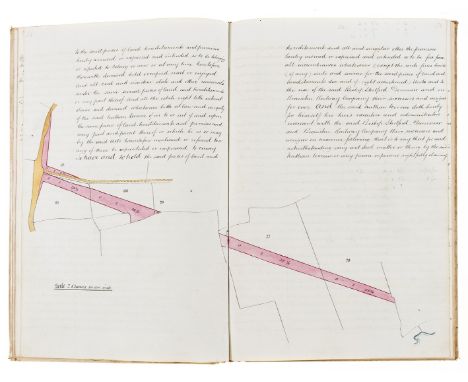
Essex, Dunmow.- The Manor of Dunmow late the Priory, manuscript, 154pp., double-page pen and ink and watercolour wash map, slightly browned, Manor of Dunmow agreement dated 1908 loosely inserted, original vellum, title lettered direct on upper cover, slightly soiled and yellowed, corners bumped, folio, 1847.⁂ This lot is sold subject to the Manorial Documents Rules and may not be removed from England & Wales.
Lot 17
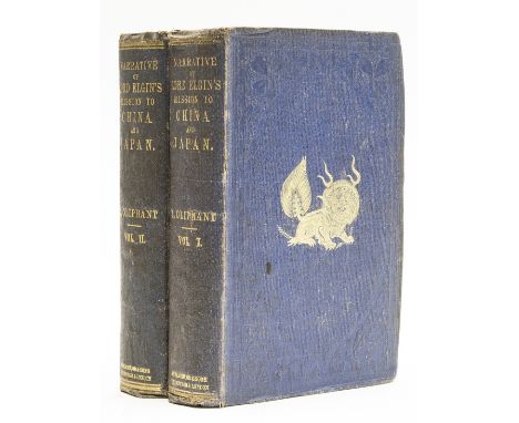
China and Japan.- Oliphant (Laurence) Narrative of the Earl of Elgin's Mission to China and Japan, 2 vol., first edition, presentation copy inscribed "Mrs. Maberly from the Author, Jan. 8 1860" on half-title, 5 folding maps and 20 lithograph plates, some chromolithograph, some tinted, wood-engraved illustrations, 16pp. publisher's catalogue at end of vol.1, large folding map at end of vol.1 torn without loss, occasional spotting or foxing, hinges starting, contents a little shaken, original pictorial cloth, gilt, spine ends and corners bumped, rubbed, 8vo, Edinburgh & London, 1859.⁂ Oliphant served as Lord Elgin's private secretary on his mission to China and Japan from 1857-59, which saw the end of the Second Opium War with the signing of the Treaties of Tianjin in 1858.

Lot 24
India.- Martin (Robert Montgomery) The Indian Empire: Its History, Topography, Government, 3 vol., engraved plates and maps, contemporary morocco, gilt, rebacked, retaining original backstrip, extremities rubbed, [c.1860] § Atkinson (George Francklin) Curry & Rice, on Forty Plates: Or, the Ingredients of Social Life at "Our Station" in India, lithographed additional pictorial title and 39 tinted lithographed plates, damp-staining, several ff. loose, original cloth, spine defective, covers detached, worn, [c.1860] § Workman (William Hunter and Fanny Bullock)Through Town and Jungle, folding map (foxed with tear to inner margin), illustrations, original pictorial cloth, gilt, t.e.g., others uncut, a little rubbed, corners bumped, 1904; and 23 others, India, including a group of mounted plates, v.s. (28)

Lot 27
Levant.- Turkey.- Carne (John) Syria, The Holy Land, Asia Minor, &c., 3 vol., first edition, engraved titles, 2 engraved maps, 117 plates, tissue-guards, occasional faint spotting, ex-library with usual labels and ink-stamps, modern morocco backed boards, a little rubbed, [1836-38] § [Pardoe (Julia)] The Beauties of the Bosphorus, engraved title, portrait frontispiece (misbound), 77 plates only (of 78) by W. H. Bartlett, 1 engraved map, letterpress title (misbound), broken upper hinge, modern rexine, rubbed, 1839; [Blackmer 291; 1254], 4to (4)

Lot 28
NO RESERVE World.- Pilot.- South and East Coasts of Korea, East Coast of Siberia, and Sea of Okhotsk Pilot, third edition, plates and illustrations, 1937; Pacific Islands Pilot volume II (Easter Groups), second edition, maps, some folding, Washington, 1920; Japan Pilot vol. 1, fourth edition, plates and illustrations, maps, 1938; Sailing Directions for Japan volume II (Southern Part), first edition, plates and illustrations, folding maps, Washington, 1943; Sailing Directions for the Western Shores of the China Sea from Singapore Strait to and including Hong Kong, fourth edition, illustrations, folding maps, Washington, 1938; East Coast of the United States Pilot vol. II only, fourth edition, illustrations, folding map, 1938, ex-library with usual stamps and labels, original cloth, a little rubbed; and 30 others, similar, 8vo (36)

Lot 29
NO RESERVE Mountaineering.- Whymper (Edward) Travels Amongst the Great Andes of the Equator, first edition, frontispiece, plates and maps with 1 large folding map in pocket at rear, upper hinge starting, original cloth, spine browned, spine ends and corners bumped, 1892; Scrambles Amongst the Alps in the Years 1860-69, fourth edition, maps, plates and illustrations, ink inscription to endpaper, original cloth, rebacked, preserving original backstrip, faded and browned, 1893 § Stone (S. J.) In and Beyond the Himalayas, first edition, plates, a few repairs to margins, staining to frontispiece, half-title and endpapers, ink stamps erased from half-title, original pictorial cloth, rebacked, preserving original backstrip, recornered, spine faded, 1896; and 8 others, mountaineering, 8vo (11)

Lot 31
New Zealand.- Alexander (Major-General James Edward) Bush Fighting ... The Maori War in New Zealand, first edition, frontispiece, plates, illustrations and 11 maps (1 folding), occasional faint spotting, cracked hinges, advertisements at end, original decorative cloth, rubbed and worn, bumping and chipping to corners and spine extremities, 1873 § Polack (J. S.) New Zealand: being a Narrative of Travels and Adventures ..., 2 vol., 6 plates (lacking vol. 1 frontispiece, another plate provided in duplicate), several plates and titles laid on linen, large folding map, tears, appendix provided from a different copy, occasional spotting and staining, modern half-morocco, 1838 § Robley (Major-General H. G.) Pounamu: Notes on New Zealand, illustrations, scattered very faint spotting, original cloth backed boards, slight bumping to corners and extremities, 1915; and 18 others, New Zealand, 8vo (22)

Lot 35
NO RESERVE New Zealand.- Nicholas (John Liddiard) Narrative of a Voyage to New Zealand, 2 vol., first edition, half-titles, engraved frontispieces (vol. 1 misbound), 2 plates (1 folding, detached and loosely inserted), 1 map only (of 2), also woodcut plate of tattoo, vol. 1 lacking title, occasional faint spotting and staining, previous owner's ink signature to half-title (vol. 2 only), publisher's advertisements at end vol. 2, modern half-morocco, 8vo, 1817.

Lot 43
Oceania.- Brenchley (Julius L.) Jottings during the Cruise of H.M.S. Curaçoa among the South Sea Islands in 1865, first edition, folding chromolithographed frontispiece, chromolithograph, 50 lithographed plates (many hand-coloured), illustrations, folding map, occasional faint spotting, ink-stamp to title, original cloth, rebacked with original spine laid down, slight bumping to corners and spine extremities, 8vo, 1865.

Lot 47
NO RESERVE Oceania.- Palmer (Captain George) Kidnapping in the South Seas, frontispiece and 3 plates, occasional faint spotting, school prize label to front pastedown, original cloth, rubbed and worn, staining to upper cover, bumping to corners and extremities, Edinburgh, 1871 § The Night of Toil, engraved frontispiece, illustrations, map, very faint spotting, contemporary half-calf, 1838 § Williams (John) A Narrative of Missionary Enterprises in the South Sea Islands, portrait frontispiece, vignette title, plates and illustrations, double-page map, occasional faint spotting, ex-library with occasional stamps, contemporary half-calf, rebacked, a little rubbed, 1837; and 23 others, South Seas, 8vo & 4to (26)

Lot 48
NO RESERVE Oceania.- Polynesia.- West (Rev. Thomas) Ten Years in South-Central Polynesia, first edition, portrait frontispiece, large folding map, double-page map, faint water staining to edge first few leaves, original cloth, a little rubbed, slight bumping to corners and extremities, 1865 § Melville (Herman) Typee: A Peep at Polynesian Life, revised edition with a sequel, occasional faint spotting, modern cloth, 1850 § Turner (Rev. George) Nineteenth Years in Polynesia, first edition, colour frontispiece, previous owner's ink signature to preface (detached), plates and illustrations, cracked hinges, occasional faint spotting, original cloth, rubbed, slight bumping to corners and extremities, 1861 § Gill (Rev. William) Gems from the Coral Islands, frontispiece, plates, occasional faint spotting, original decorative cloth, slight bumping to corners and extremities, Philadelphia, n.d.; and 16 others, Polynesia, v.s. (20)

Lot 52
NO RESERVE Oceania.- Stevenson (Robert Louis) A Footnote to History: eight years of trouble in Samoa, first edition, map frontispiece, occasional faint spotting, original cloth, slight bumping to corners and extremities, 1892; Vailima Letters being correspondence addressed ... to Sidney Colvin, first edition, portrait frontispiece, original buckram, rubbed and worn, slight bumping to corners and extremities, 1895; In the South Seas, first edition, original cloth, slight bumping to corners and extremities, 1900; 8vo (3)
Lot 57
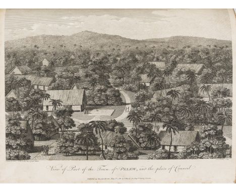
Pacific.- Keate (George) An Account of the Pelew Islands...composed from the Journals and Communications of Captain Henry Wilson, first edition, stipple-engraved portrait frontispiece, folding engraved map, 15 engraved plates (some stipple-engraved) including folding panorama, occasional light offsetting and some marginal damp-staining, errata f., 20th century half roan, [Hill 907], 4to, 1788.⁂ "In 1783 the Antelope, commanded by Captain Henry Wilson, was wrecked on a reef near one of the Palau (Pelew) Islands, a previously unexplored group. The entire crew managed to get safely ashore, where they were well treated by the natives and eventually managed to build a small vessel from the wreck, in which they reached Macao. They took Prince Lee Boo, one of King Abba Thulle's sons, with them to England, where he made a very good impression. Unhappily, in spite of all precautions, he soon died of smallpox." Hill

Lot 59
Pacific.- Tahiti.- Missionary Records. Tahiti and Society Islands, first edition, folding engraved map frontispiece (a little creased), modern half calf, [c.1835] § Keable (Robert) Tahiti: Isle of Dreams, photographic plates, 20th century crushed blue morocco, gilt, by Oxford, spine slightly faded, g.e., n.d. § Clark (Thomas Blake) Omai, First Polynesian Ambassador to England, signed presentation inscription from the author to endpaper, portrait frontispiece, some foxing, original cloth-backed boards, spine and covers a little browned, 1941; and 9 others, Tahiti and French Polynesia, v.s. (12)

Lot 60
NO RESERVE Pacific.- Tahiti.- Adams (Henry) Memoirs of Arii Taimai E. Marama of Eimeo Teriirere of Tooarai. Teriinui of Tahiti Tauraatua I Amo, half-title, double-page map of Tahiti, pp. 57/58 supplied in good facsimile mounted on stub, dampstaining (mostly marginal) and occasional soiling, modern half calf, uncut, 4to, Paris, [Privately printed], 1901.⁂ Rare second edition, revised and expanded from the yet more rare first edition of 1893. Based on legendary tales that Adams heard from the Queen of Tahiti and her family while on a trip to the South Seas.
Lot 61
Pacific Islands.- Tilley (Henry Arthur) Japan, the Amoor, and the Pacific, first edition, tinted lithograph frontispiece and 7 plates, tissue-guards, occasional faint spotting, bookplate, original cloth, remnants of label to upper cover, rubbed, bumping to corners and extremities, 1861 § Hood (T. H.) Notes on a Cruise in H.M.S. "Fawn" in the Western Pacific, first edition, tinted lithograph frontispiece, plates and illustrations, folding map, occasional spotting and soiling, contemporary cloth, slight bumping to corners and extremities, Edinburgh, 1863 § Lamont (E. H.) Wild Life among the Pacific Islanders, frontispiece, plates, occasional spotting, original decorative cloth, rubbed, bumping to corners and extremities, 1867; and 43 others, Pacific Islands, 8vo (46)

Lot 75
Voyages.- Mercier (W.) The Life of La Perouse, the celebrated and unfortunate French Navigator ... in a Desolate Island on the North Coast of Japan, title closely trimmed, staining and tearing to first few leaves, small loss to B2, several leaves strengthened at hinge, lack all after p.62, modern cloth, Sommers Town, A. Neil, [?1801] § Seemann (Berthold) Narrative of the Voyage of H.M.S. Herald during the Years 1845-51, 2 vol. bound in 1, first edition, 2 colour lithographs, lacking folding map, prize inscription, occasional spotting, cracked hinges, original decorative cloth, sunned spine, rubbed and worn, bumping to corners and extremities, [Sabin 78867], 1853 § Herrera (Antonius de) De Roemwaardige Scheeps-Togt van Christoffel Kolumbus ..., 5 folding engraved plates, occasional faint spotting, title in ink to modern front free endpaper, disbound, Leyden, Pieter van der Aa, n.d.; and others, voyages, v.s. (33)⁂ The first is very scarce with only one copy on JISC Library Hub, at the University of Oxford.

Lot 8
Atlases.- Johnston (Alexander Keith) Atlas of General and Descriptive Geography, 26 maps on 25 sheets, all printed in blue and black and finely hand-coloured in outline, a few with marginal foxing or soiling, modern half calf, g.e., 1863; The Royal Atlas of Modern Geography, 48 double-page maps hand-coloured in outline, with watercourses printed in blue and some inset city plans, Germany with folding flap, mounted on stubs, interleaved with indices for each map, some foxing, advertisement for Index tipped in at beginning, book-label on front pastedown with name erased, contemporary half green morocco, spine gilt, g.e., a little rubbed, 1872, 4to & folio, Edinburgh and London (2)

Lot 82
NO RESERVE Burton (Sir Richard Francis).- Journal of the Royal Geographical Society, vol. 49, first edition, 4 folding colour-printed maps, 12pp. advertisements, 1879; and 2 others, Royal Geographical Society (3)⁂ Vol. 49 includes Burton's "Itineraries of the Second Khedivial Expedition: Memoir explaining the New Map of Midian made by the Egyptian Staff-oficers"; and, "A Visit to Lissa and Pelagosa." The two Burton contributions are responsible for more than half the text in this report.
![Falkland Islands.- [Moreno (Manuel)] Reclamacion del gobierno de las provincias unidas del Rio de La Plata contra el de su Ma](https://cdn.globalauctionplatform.com/d8aab662-74ef-4288-9094-ac0900c4bfcd/0a847fbc-b56f-4911-9eb3-ac090109c479/468x382.jpg)
Lot 85
Falkland Islands.- [Moreno (Manuel)] Reclamacion del gobierno de las provincias unidas del Rio de La Plata contra el de su Magestad Britanica sobre la soberanía y posesion de las Islas Malvinas (Falkland), double column, folding engraved map, very short tear at head of title, water-stained, mostly marginal, spotting, lightly browned, 20th century cloth, rubbed and marked, 4to, for Arturo Carlos Luthman, 1841.⁂ Rare work on the sovereignty of the Falkland Islands. Library Hub lists only one copy (King's College, London).

Lot 87
NO RESERVE India.- Malleson (Maj. G.B.) History of the French in India from the Founding of the Pondichery in 1674 to the Capture of that Place in 1761, first edition, half-title, folding engraved map, hand-coloured in outline, 2 lithographed maps, errata-slip, occasional spotting, original green cloth, rebacked, preserving original backstrip, corners little worn, rubbed, 1868; and another, a history of Sanskrit Literature, 1832, 8vo (2)
Lot 9
Atlases.- Russell (John) and others. A Complete Atlas of the World, Printed at the Caxton Press, engraved hand-colour frontispiece and 33 maps (3 folding), folding map of Great Britain with tears along folds, occasional light browning or finger-soiling to margins, modern half calf, 4to, [c.1840].⁂ A scarce atlas, the map of the United States includes mention of the short-lived state Franklinia.

Lot 92
NO RESERVE South America.- Mackinnon (Cdr. Lauchlan Bellingham) Steam Warfare in the Parana: A Narrative of Operations, 2 vol., first edition, half-title, folding lithographed map, 3 wood-engraved plates, some staining and spotting, original cloth, spines repaired with tape, faded and rubbed, 8vo, 1848.
![Devon.- [Butcher (Edmund)] The Beauties of Sidmouth Displayed, second edition, 7 aquatint plates printed in bistre, folding e](https://cdn.globalauctionplatform.com/d8aab662-74ef-4288-9094-ac0900c4bfcd/a5b9659b-adc5-4757-976c-ac09010976a8/468x382.jpg)


Lot 243
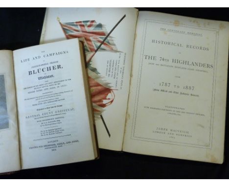
AUGUST WILHELM ANTON GRAF NEIDHART VON GNEISENAU: THE LIFE AND CAMPAIGNS OF FIELD-MARSHAL PRINCE BLUCHER OF WAHLSTATT..., trans with considerable additions J E Marston, London for Sherwood Neely & Jones, 1815, 1st edition, engraved portfrontis, plans and map as list, old half calf worn, spine gilt in compartments, morocco gilt labels + [JAMES MACVEIGH]: THE CENTENARY MEMORIAL HISTORICAL RECORDS OF THE 74TH HIGHLANDERS (NOW 2ND BATTALION HIGHLAND LIGHT INFANTRY) FROM 1787 TO 1887, London and Dumfries, James McVeigh, 1887, 1st edition, coloured frontis, 2 engraved portrait plates, 4to, contemporary grained morocco gilt, v worn, lacks most of backstrip (2)

Lot 384
JAMES STANIER CLARKE & JOHN M'ARTHUR: THE LIFE AND SERVICES OF HORATIO VISCOUNT NELSON, London, Fisher Son & Co [1839-40], 2nd edition, 3 volumes, added engraved titles, frontispieces, 33 plates including folding map, original blind stamped ribbed cloth gilt, spines faded, armorial bookplates of Hastings (3)

Lot 411
GEORGE PEACOCK: NOTES ON THE ISTHMUS OF PANAMA AND DARIEN, ALSO ON THE RIVER ST JUAN, LAKES OF NICARAGUA ETC WITH REFERENCE TO A RAILROAD AND CANAL ADJOINING THE ATLANTIC AND PACIFIC OCEANS, Exeter, W Pollard, 1879, 1st edition, inscribed presentation copy on 1st preface page, folding litho frontis map, 2 folding plans as called for, original cloth gilt
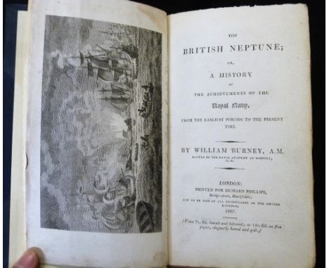
Lot 415
WILLIAM BURNEY: THE BRITISH NEPTUNE OR A HISTORY OF THE ACHIEVEMENTS OF THE ROYAL NAVY FROM THE EARLIEST PERIODS TO THE PRESENT TIME, London for Richard Phillips, 1807, 1st edition, 8 engraved plates, folding map (bound in at front), 30pp adverts at end, uncut, 12mo, rebound half blue morocco, spine gilt in compartments, new end papers


Lot 65
IAN SINCLAIR: HACKNEY THAT ROSE-RED EMPIRE, ill Una Grimes, London, Hamish Hamilton/London Review Bookshop, 2009, (50) (45), numbered and signed, original black cloth backed watered silk, original solander box containing etching by Una Grimes, folding map of Hackney and a holograph postcard with original text by the author as called for, vgc


-
109182 item(s)/page