We found 109198 price guide item(s) matching your search
There are 109198 lots that match your search criteria. Subscribe now to get instant access to the full price guide service.
Click here to subscribe- List
- Grid
-
109198 item(s)/page
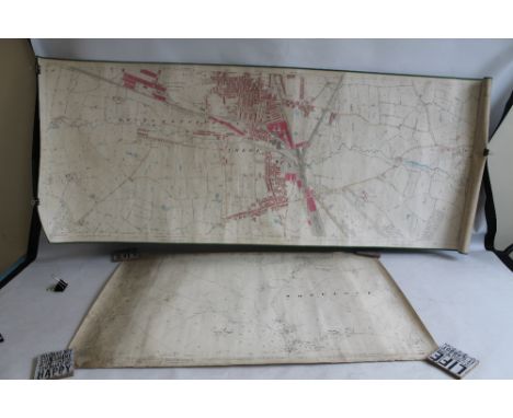

Lot 286
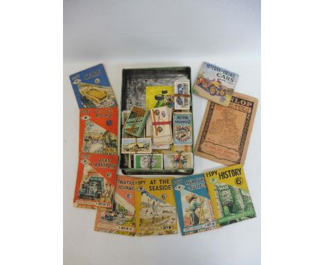
A "Philips' Series of Dissected Maps - Scotland" by Philip & Tacey Limited, a "Dissected Map of England and Wales" by W Peacock, GWR jigsaw puzzle "GWR Locomotives in the Making", CP jigsaw puzzle "London Highways", a Victory puzzle "1920 Foster Traction Engine" and a WH Smith jigsaw "Playing the Day Away"


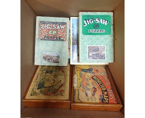
Lot 11
Polar.- Back (Sir George) Narrative of the Arctic Land Expedition to the Mouth of the Great Fish River and along the Shores of the Arctic Ocean, in the Years 1833, 1834, and 1835, first edition, 16 engraved and lithographed plates, 1 large folding map at end, short tear to inner edge, illustrations, cracked hinges, faint spotting to first and last few leaves, bookplate, later half morocco, a little rubbed, 1836.⁂ Bookplate of Almeric Hugh Paget, first Baron Queenborough.
Lot 128
Danet (Guillaume) A Complete Dictionary of the Greek and Roman Antiquities, first English edition, approbation f. at beginning, 3 folding engraved maps, advertisement f. at end, 1 map trimmed to border and laid down, occasional spotting, a few small stains, contemporary calf, rebacked, rubbed, [Wing D171], for John Nicholson, 1700; and 14 others, Molière and Corneille, small 4to et infra (15)
![NO RESERVE [Playstowe (Philip)] "An Officer". The Gentleman's Guide in His Tour Through France..., fifth edition, large foldi](https://cdn.globalauctionplatform.com/f65b37a5-bb7b-4d51-a5e7-aa3301133ee4/4f4d9b43-4e03-4d92-a363-aa3800ae421a/468x382.jpg)
Lot 141
NO RESERVE [Playstowe (Philip)] "An Officer". The Gentleman's Guide in His Tour Through France..., fifth edition, large folding map, with loss, scattered browning, several ff. with closed tears, for G.Kearsly, 1772 § Fielding (Henry) The History of the Adventures of Joseph Andrews..., 2 vol., half-titles, a little browning to endpapers, worming to front pastedowns, hinges splitting a little, Paris, J. Fr. Valade, 1779 § [Mouhy (Charles de Fieux de)] The Busy-Body: or, Successful Spy..., 2 vol., half-titles, woodcut head- and tail-pieces, foxing and soiling, contents separating a little, hinges pulling, for F.Cogan, 1742, first half green morocco, second later vellum-backed boards, last contemporary calf, first rubbed, others worn, second loss at spine ends and with several worm holes and trails, last joints splitting and spine friable, also with loss at ends; and c.70 others, v.s. (c.75) ⁂The first rare in any edition: ESTC traces 3 copies of the fifth edition: in the British Library, the Thomas Plume Library, and the Maria Curie-Skłodowska University Library in Poland.The translation of last sometimes attributed to Eliza Haywood: it is likely that she was involved with the publication or distribution of the novel.
Lot 15
NO RESERVE Bedfordshire.- Lysons (Rev. Daniel) Magna Britannia; Being a Concise Topographical Account of ... Great Britain., vol. 1 part 1. only, Bedfordshire, extra illustrated, half-title, dedication leaf, 1 double-page engraved map, 92 plates, 25 hand-coloured, 2 double-page, newspaper article trimmed and laid down on blank, manuscript list of plates bound-in at end, occasional faint spotting, later half-morocco, a little rubbed, slight bumping to corners and extremities, 1806
Lot 16
NO RESERVE Lancashire.- Manchester.- Gregson (Matthew) Portfolio of Fragments relative to the ... Duchy of Lancaster, third edition, ?large paper copy, half-title, engraved portrait frontispiece, 22 plates, 3 folding, 1 folding map, illustrations, some coloured by hand, list of subscriber's to large paper impression bound at beginning, some marginal tears, neatly repaired, one or two edges strengthened with tape, ex-library with usual stamps to title verso, modern half calf, 1869 § [Manchester]. The Court Leet Records of the Manor of Manchester ..., vols. 1-7 only (of 12), occasional faint spotting, bookplate, contemporary half vellum, a little rubbed, Manchester, 1884-88; and 6 others, similar, v.s. (14)


Lot 395
A collection of topographical books, to include Ordnance Survey Atlas of Great Britain, Ancient Britain the South sheet and the North sheet, map of the major visible antiquities, The English Lakes by W T Palmer, Animal Life of the British Isles by Edward Step, Ward Lock & Co's Sheringham and Inverness Guide books, Views of the English Lakes published by J Garnet Windermere, Wild Lakeland painted by A Heaton Cooper, described by MacKenzie MacBride, Fream's Elements of Agriculture, Warwickshire painted by Fred Whitehead described by Clive Holland and three Italian guide books, Venezia, Pompei and Napoli

Lot 83
A 19th century rosewood library folio cabinet, having a leather inset metamorphic writing top, the two doors below opening to reveal shelving and map chest, 34.25ins x 53ins x 36.5insCondition Report: Leather scuffed, marked,stained and torn in places. Pins missing to base and stand. Various other stains and marks commensurate with age. Door jam possibly replaced. Probably 19th century.


Lot 323
A mixed lot of interesting things, to include a rosewood cigar box with cross and shield to top, plated crumb catcher and sandwich box, a Sifton, Praed & Co linen backed map of Surrey, a cushioned vlevet brush with impressed label 'Magazin du Louvre, Paris', together with a silver cylindrical box, Birmingahm 1916, WM to lid


Lot 224
WW1 Cheshire/Labour Corps Casualty “Time Capsule” Collectionconsisting silver War and Victory medals named to “35646 Sjt A Ellis Ches R” in boxes of issue ... WW1 casualty plaque named to “Albert Ellis” in box of issue with letter ... Casualty scroll named to “Sergt Albert Ellis Cheshire Reg” in postal tube ... Glory of God memorial scroll with his details ... Cotton printed map of France from “Manchester Guardian” ... His dog tags ... Bible ... Steel cigarette case ... Pipe ... Wallet. Most comprehensive collection. Sergent Albert Ellis 19th Batt Cheshire Reg / 58th Coy Labour Corps. Born and enlisted Mossley Lancs. Died 28/7/1917, age 23. Husband of Eveline Ellis 48 Manchester Rd, Mossley, Manchester. Buried Canada Farm cemetery.


Lot 508
WW2 German Invasion Map Folder For South West Englandgreen folder. The front printed “10. Sudwest - England”. Contains large fold out map Blatt NR 7, covering Devon & Cornwall ... Street map of Torquay and area ... Street map of Exeter and area ... Street map of Plymouth and area ... Photographic booklet of Devon and Cornwall.

![[CHILDRENS] Milne, A.A. Winnie-the-Pooh, second edition, Methuen, London, 1926, dark green cloth gilt, top edges gilt, map e](https://cdn.globalauctionplatform.com/96fa8808-0964-41ec-9ebb-aa3600d9f6b5/3d2c4cb2-2d50-4c7f-9181-aa3b0111c3f4/468x382.jpg)
Lot 433
[CHILDRENS] Milne, A.A. Winnie-the-Pooh, second edition, Methuen, London, 1926, dark green cloth gilt, top edges gilt, map endpapers, illustrations by Ernest Shepard, octavo; with Now We Are Six, first edition, Methuen, London, 1927, maroon cloth gilt, top edges gilt, illustrated endpapers, illustrations by Ernest Shepard, octavo; The House at Pooh Corner, first edition, Methuen, London, 1928, pink cloth gilt, top edges gilt, silhouette endpapers, illustrations by Ernest Shepard, octavo; and When We Were Very Young, third edition, Methuen, London, 1924, navy blue cloth gilt, top edges gilt, illustrated endpapers, illustrations by Ernest Shepard, octavo, (4).
![[TOPOGRAPHY]. LANCASHIRE West, Thomas. The Antiquities of Furness; or, An Account of the Royal Abbey of St. Mary, in the Val](https://cdn.globalauctionplatform.com/96fa8808-0964-41ec-9ebb-aa3600d9f6b5/4a807bc0-6a9f-4af0-b421-aa3b011201e4/468x382.jpg)
Lot 473
[TOPOGRAPHY]. LANCASHIRE West, Thomas. The Antiquities of Furness; or, An Account of the Royal Abbey of St. Mary, in the Vale of Nightshade, near Dalton in Furness, belonging to the Right Honorable Lord George Cavendish, for the author by Spilsbury, London, 1774, full speckled calf, engraved folding frontispiece, three further engraved plate illustrations (two folding, including map), quarto (upper board almost detached; lower joint partially cracked; lacking head and tail bands; old marginal worm to final twelve leaves, not affecting text); and Stockdale, James. Annales Caermoelenses: or Annals of Cartmel, Kitchin / Simpkin, Marshall & Co., Ulverston / London, 1872, original bevelled purple cloth gilt, frontispiece, four further plate illustrations, octavo (spine faded to brown, with nicked ends; newspaper cuttings and other ephemera pasted to front free endpaper, half title and rear pastedown), (2).
![[TOPOGRAPHY]. LIVERPOOL (LANCASHIRE; MERSEYSIDE) Brooke, Richard. Liverpool as it was, During the Last Quarter of the Eighte](https://cdn.globalauctionplatform.com/96fa8808-0964-41ec-9ebb-aa3600d9f6b5/10c66859-83f5-43fc-bfa7-aa3b0112051b/468x382.jpg)
Lot 475
[TOPOGRAPHY]. LIVERPOOL (LANCASHIRE; MERSEYSIDE) Brooke, Richard. Liverpool as it was, During the Last Quarter of the Eighteenth Century 1775 to 1800, Mawdesley & Son, Liverpool, 1853, original blind-stamped dark green cloth, frontispiece and a further five engraved plate illustrations (as called for), quarto; Boardman, James. Liverpool Table Talk a Hundred Years Ago, or A History of Gore's Directory, with Stonehouse, James. A History of the Streets of Liverpool, bound as one, Howell, Liverpool, 1882, original crimson cloth, folding map frontispiece, octavo; and a work of Cheshire interest, (3).
![[TOPOGRAPHY]. GREAT BRITAIN Blome, Richard. Britannia: or, A Geographical Description of the Kingdoms of England, Scotland,](https://cdn.globalauctionplatform.com/96fa8808-0964-41ec-9ebb-aa3600d9f6b5/9b4905d2-eac0-472d-a01e-aa3b01120700/468x382.jpg)
Lot 476
[TOPOGRAPHY]. GREAT BRITAIN Blome, Richard. Britannia: or, A Geographical Description of the Kingdoms of England, Scotland, and Ireland, with the Isles and Territories thereto belonging, by Tho. Roycroft, London, 1673, full leather (re-backed and with re-built corners), title page in red and black, four general folding maps (North Wales; South Wales; Scotland; Ireland, only), forty-four double-spread county maps, double-spread combined map of off-shore islands, plan of London, twenty-four pages of engraved coats-of-arms, small folio.
![[TOPOGRAPHY]. SOMERSET Wedmore Chronicle, Volume 1, 1881 to 1887, Atkins / Pople, Wells / Wedmore, 1887, bevelled maroon clo](https://cdn.globalauctionplatform.com/96fa8808-0964-41ec-9ebb-aa3600d9f6b5/f803f46d-1dbf-4953-98f1-aa3c00a97d98/468x382.jpg)
Lot 478
[TOPOGRAPHY]. SOMERSET Wedmore Chronicle, Volume 1, 1881 to 1887, Atkins / Pople, Wells / Wedmore, 1887, bevelled maroon cloth, illustrations, quarto; with Wedmore Chronicle, Volume 2, 1888 to 1898, Pople, Wedmore, 1898, bevelled scarlet cloth, illustrations, quarto (both volumes worn); and Kelly's Directory of Somersetshire and Bristol 1897, crimson cloth, folding map of Bristol (detached; torn, without loss), period advertisements, quarto, (3). Note: This lot sold with all faults, not subject to return.
![[MAPS & ATLASES]. NOTTINGHAMSHIRE Speed, John (1552-1629) & Hondius, Jodocus (1563-1612), 'The Countie of Nottingham](https://cdn.globalauctionplatform.com/96fa8808-0964-41ec-9ebb-aa3600d9f6b5/1503bc97-0ff8-4e44-aed8-aa3b0112341a/468x382.jpg)
![[MAPS & ATLASES]. SHROPSHIRE Speed, John (1552-1629), 'Shropshyre Described', engraved county map, sold by George Humble](https://cdn.globalauctionplatform.com/96fa8808-0964-41ec-9ebb-aa3600d9f6b5/0576e1b9-3a54-49e4-baad-aa3b011236ff/468x382.jpg)
![[MAPS & ATLASES]. WALES Speed, John (1552-1629), 'Wales', engraved map, sold by John Sudbury and George Humble, hand-col](https://cdn.globalauctionplatform.com/96fa8808-0964-41ec-9ebb-aa3600d9f6b5/59645594-3acd-4aa7-98cd-aa3b011239fe/468x382.jpg)
![[MAPS & ATLASES]. CAMBRIDGESHIRE Blaeu, Johannes (1596-1673), 'Cantabrigiensis Comitatus / Cambridge Shire', engraved co](https://cdn.globalauctionplatform.com/96fa8808-0964-41ec-9ebb-aa3600d9f6b5/7a4a4671-ff59-42ff-ac55-aa3b01123cdd/468x382.jpg)
![[MAPS & ATLASES]. HEREFORDSHIRE Bowen, Emanuel (1694?-1767), 'Hereford Shire', engraved county map, hand-coloured in out](https://cdn.globalauctionplatform.com/96fa8808-0964-41ec-9ebb-aa3600d9f6b5/9adda49b-2f73-4731-a447-aa3b01123f79/468x382.jpg)
![[MAPS & ATLASES]. CHINA A folding 'Map of the China Coast and Rough Sketch of the Provinces lying between Canton and Pek](https://cdn.globalauctionplatform.com/96fa8808-0964-41ec-9ebb-aa3600d9f6b5/11bbe114-9876-436c-a666-aa3b011243d2/468x382.jpg)
Lot 511
[MAPS & ATLASES]. CHINA A folding 'Map of the China Coast and Rough Sketch of the Provinces lying between Canton and Pekin', 1860, approximate scale 24 miles-to-the-inch, published by the Surveyor General's Office, Calcutta, hand-coloured in outline and linen-backed, 151cm x 112cm. Provenance: Major-General Sir Peter Scratchley, K.C.M.G., Royal Engineers (1835-1885), thence by direct family descent.
![[MAPS & ATLASES]. GREAT BRITAIN A folding 'Railway Map of the British Isles and Part of France', published by B.R. Davie](https://cdn.globalauctionplatform.com/96fa8808-0964-41ec-9ebb-aa3600d9f6b5/c67ac117-41a2-4160-8968-aa3b01124553/468x382.jpg)
![[MAPS & ATLASES]. INDIA The Automobile Association of Northern India [folding] Road Map, no date, scale 1/1000000 or 1.0](https://cdn.globalauctionplatform.com/96fa8808-0964-41ec-9ebb-aa3600d9f6b5/7e19c743-1374-4c6b-bd99-aa3b01124b25/468x382.jpg)


-
109198 item(s)/page