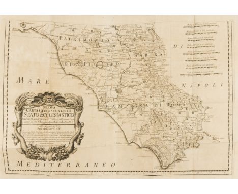

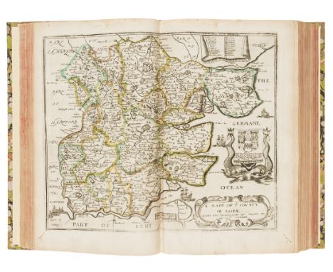
Geodesy.- Maire (Christophe) and Ruggiero Giuseppe Boscovich. De litteraria expeditione per Pontificiam ditionem ad dimetiendos duos meridiani gradus et corrigendeam mappam geographicam, first edition, half-title, title in red and black with woodcut device, woodcut initials and decorations, 4 folding engraved plates and map on 3 folding engraved sheets, some foxing and browning, marginal repair to first leaf of dedication, minor worming to endpapers, just slightly encroaching on title and margin of final map sheet, contemporary vellum, head of spine torn and slight worming to spine head and foot, [Honeyman 2115 without the map], 4to, Rome, Nicolaus and Marcus Palearini, 1755.⁂ Important work on the shape of the earth, confirming the Newtonian theory that it was ellipsoid and flattened at the poles. Pope Benedict XIV commissioned the two scientists to measure an arc of the meridian and create a new map of the papal states. The map would appear to have been issued separately and it is rarely found complete with the accompanying text volume.
We found 109198 price guide item(s) matching your search
There are 109198 lots that match your search criteria. Subscribe now to get instant access to the full price guide service.
Click here to subscribe- List
- Grid
-
109198 item(s)/page
Americas.- West Indies.- Willyams (Rev. Cooper) An Account of the Campaign in the West Indies, in the year 1794, first edition, list of subscribers, engraved map and plan, 2 aquatint vignettes in text, without the 6 aquatint plates issued separately but bound in with the large paper folio copies, light offsetting, bookplate of Ramsey Abbey, contemporary sprinkled calf with Greek key border in blind, spine gilt with anchors in compartments, a little rubbed, upper joint split, [Sabin 104563; cf.Abbey, Travel 677, large paper], T. Bensley, for G. Nicol, 1796.
Bible, English. The Holy Bible, first edition of the King James Bible, the Great 'He' Bible, largely printed in black letter, double column, woodcut initials and head- and tail-pieces, general title lacking and provided in facsimile, lacking double-page woodcut map, all other leaves including woodcut title to NT present, calendar printed in red and black, 3G5 torn, several leaves (especially 3P4 and 3P6 in OT, C4-D2, F2, F5, H3-4, K5, M5, R2 and R5 in NT) with marginal repairs and /or corners defective and most with missing words supplied in manuscript, lower portion of P5 in NT cut away with loss of bottom 6 lines of text one recto and verso, some other more minor marginal repairs, tear to final leaf, stain to lower edge throughout, mostly marginal but and beginning and particularly at end encroaching into text block, other occasional damp- and ink-stains, remboitage in old calf, rebacked, gilt-metal corner and centre-pieces, lacking clasps, [Herbert 309; Pforzheimer 61; PMM 114; STC 2216], folio (398 x 250mm.), [Robert Barker], 1611.⁂ Widely regarded as the greatest literary translation of the Bible ever produced and arguably the most important and influential book published in English. This Royal version took over 5 years to complete and used more than 50 translators; it is known as the Great 'He' Bible after the reading (on Bb2 recto) in Ruth 3:15 "and he went into the citie".
America.- Kalm (Peter) Reis door Noord Amerika, first edition in Dutch, half-title, additional engraved title, large folding map and 4 plates (1 folding), uncut in contemporary half vellum over Dutch floral boards, foot of spine and corners worn, [Howes K5; Lande 483; Sabin 36988], 4to, Utrecht, J. van Schoonhoven, 1772.⁂ An attractive copy of this important edition which Lande calls "far superior to the [original] Swedish and English editions."
![Bible, English. [The Bible], NT within heart shaped border, black letter, double column, lacks OT title, bound after defectiv](https://cdn.globalauctionplatform.com/2bd0514c-2503-487c-bb62-a98800b53ee8/90410ade-f210-461d-96c6-a988011cee1c/468x382.jpg)
Bible, English. [The Bible], NT within heart shaped border, black letter, double column, lacks OT title, bound after defective Book of Common Prayer and a complete Genealogies and double-page map of Canaan, incomplete Booke of Psalmes at end, browned, some slight staining, some leaves frayed and slightly defective at edges, some marginal tears, ink inscriptions of John Dickinson dated 1695 throughout, ink stamp of Maidstone Museum on an early leaf, disbound, worn remains of spine and lower defective lower cover loose, [?Herbert 330], 4to, Robert Barker, 1613 [1614]; sold not subject to return.
Americas.- Sayer (Robert) & John Bennet, publishers. The American Military Pocket Atlas...of the British Colonies..., first edition, variant issue without colon after "London" in imprint, 6 folding engraved maps hand-coloured in outline, all mounted on stubs, some light soiling or offsetting, map 4 'Middle British Colonies' with small stain, imprint of map 6 'Lake Champlain' shaved at foot, a few small tears repaired (mostly to folds), bookplate of Heinrich Johann, Freiherr von Gudenus dated 1891 on front pastedown, contemporary calf-backed marbled boards, spine ruled in gilt and with green morocco label, uncut, a little rubbed, spine slightly worn at foot, still a good copy, [Sabin 1147 & 1343], 8vo, R.Sayer and J.Bennet, 1776.⁂ Known as the 'Holster Atlas' this work was designed for and issued to British cavalry officers for use in the field during the American War of Independence. It was "calculated in its Bulk and Price to suit the Pockets of Officers of all Ranks" (from the Advertisement leaf).
![Voyages.- Cook (Capt. James).- [Rickman (John)] Journal of Captain Cook's last Voyage to the Pacific Ocean, on Discovery, per](https://cdn.globalauctionplatform.com/2bd0514c-2503-487c-bb62-a98800b53ee8/d86c3523-f35a-456e-9f17-a988011b8e94/468x382.jpg)
Voyages.- Cook (Capt. James).- [Rickman (John)] Journal of Captain Cook's last Voyage to the Pacific Ocean, on Discovery, performed in the years 1776, 1777, 1778, 1779, first Dublin edition, folding engraved map, 5 engraved plates, contemporary ink inscription "1782 January 28th Will. Fairbrother" at head of title and with his engraved bookplate loosely inserted, light staining to title, occasional soiling, short tear to O1 without loss, contemporary calf, slightly rubbed, small worn patch to upper cover, rebacked preserving old morocco label, [Beddie 1608], 8vo, Dublin, for Messrs. Price [& others], 1781.⁂ The first Dublin edition of the first published account of Cook's last voyage, preceding the authorized version by three years. The text is a reprint of the second London edition of the same year with corrections and some plates reversed. Rickman was second lieutenant on the Discovery. The frontispiece depicts the death of Cook.
World.- Mallet (Allain Manesson) Description de l'Univers, 5 vol., first edition in French, 5 additional engraved pictorial titles, 2 portraits, and 684 full-page maps and illustrations, some double-page but numbered as single pages), numbering erratic, several with another map/plate pasted over the original (nos.12, 57 & 81 in vol.2, 5 & 11 in vol.3, 128 in vol.4 & 23 in vol.5), some light soiling, browning to a few leaves in vol.3, slight staining to plates 93 in vol.1, 80-82 in vol.2 & 69/70 in vol.5, one or two minor marginal defects, contemporary sprinkled calf, spines gilt, rubbed, spine ends a little worn and chipped, some repairs, [Sabin 44130], 8vo, Paris, Denys Thierry, 1683.⁂ A good clean and complete copy of this important atlas from the Grand Siècle. The copious illustrations and maps cover all parts of the known world, as well as the heavens.
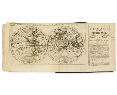
Americas.- South America.- Cooke (Capt. Edward) A Voyage to the South Sea, and Round the World, perform'd in the Years 1708, 1709, 1710, and 1711, first edition, 20 engraved maps and plates, 3 folding (double-hemisphere map of world, map of River Amazon, city of Cusco), advertisement leaf at end, contemporary ink inscription "Mary Lowther 1744" on title, lightly browned, contemporary panelled calf, rebacked with gilt spine and red roan label, later endpapers, rubbed, corners and spine ends worn, upper joint split, [Sabin 16303; cf. Hill 372, second edition], 8vo, by H.M. for B.Lintot and R.Gosling...A.Bettesworth...and W.Innys, 1712.⁂ The rare true first edition, published in only one volume, of this buccaneering expedition around the world led by Capt. Woodes Rogers in 1708-11. Cooke and Rogers each rushed to publish an account; the second edition of Cooke's work expanded his final chapter into another volume. During the voyage they rescued Alexander Selkirk who had been marooned on the island of Juan Fernandez four years previously. "It is generally supposed that De Foe took his "Robinson Crusoe" from the account here given of Alex. Selkirk, as it was the first book containing it." Sabin

Lyne (Samuel, London based bookseller, map/chart seller and print seller, fl. 1741-1751) A Merry Tale of the Jealous Weaver, satirical broadside, with two vignettes of the "Weaver", one showing him at work with his wife warming beside an open fire, the other showing the him in disguise as a Friar receiving his wife for confession, engraving on laid paper with large "Pro Patria" watermark, sheet 135 x 245 mm. (5 1/4 x 9 5/8 in), light browning and surface dirt, small tear in the upper right, unframed, [ca. 1740s].⁂ Rare. ESTC records no other copies; not in BM Satires.
Polar.- Franklin (Sir John) Narrative of a Journey to the Shores of the Polar Sea, in the years 1819, 20, 21, and 22, first edition, second issue, with 4 folding engraved maps, one with outline hand-colouring, and 31 engraved plates by Edward Finden and J.Curtis after Curtis, George Back & Robert Hood, 12 hand-coloured (mostly aquatints), tissue guards, title and coloured map browned, occasional some foxing, contemporary half calf, rubbed, [Abbey, Travel 635; Hill 635; Sabin 25624], 4to, 1823.⁂ Account of Franklin's first expedition which included a 5500 mile overland journey exploring the Arctic coast and back across the Barren Lands in appalling conditions of cold and hunger. Many of the expedition died as a result and one was murdered by a previously-friendly Iroquois voyageur. This second issue is scarcer than the first and contains an additional colour plate.
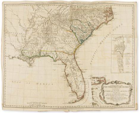
Britain.- Blome (Richard) Britannia: or, A Geographical Description of the Kingdoms of England, Scotland, and Ireland..., first edition, title in red & black, 5 folding engraved general maps (of 6, lacking general map of Britain), 44 double-page engraved county maps and engraved plan of London, all but 16 county maps and plan with contemporary outline hand-colouring, also lacking 10pp. Preface/'Alphabetical Table of Benefactors' and 24pp. of engraved coats-of-arms, title with contemporary signature of Thos. Dade at head and browned and slightly defective (laid down), dedication leaf spotted and frayed at edges (reinforced), some other spotting and staining especially ink stains to map of Somerset, occasional light worming to lower outer corner, a few minor repairs, modern morocco-backed marbled boards, [Chubb XCIX; Wing B3207], folio, Tho. Roycroft for...Richard Blome, 1673; sold not subject to return
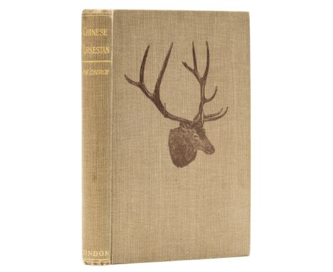
Central Asia.- Big Game.- Church (Percy W.) Chinese Turkestan with Caravan and Rifle, first edition, half-title, photogravure frontispiece of head of wapiti, photographic plates, folding map at end, very occasional spotting, bookplate of Walter Harold Wilkin, free endpapers browned, front with old ink stamp at head, original pictorial grey cloth with head of wapiti, very slight marking to lower cover but an excellent copy, [Czech, Asian, p.47; Yakushi C264], 8vo, 1901.⁂ Account of a sporting tour in Central Asia in search of wapiti and ibex.
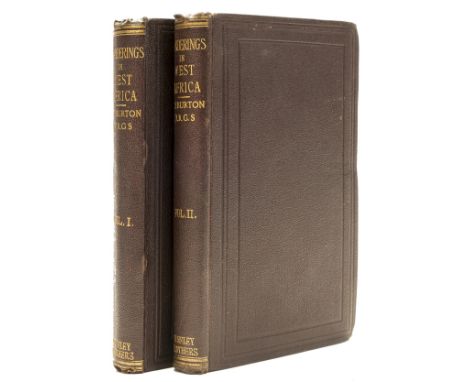
NO RESERVE Africa.- Burton (Sir Richard Francis) Wanderings in West Africa from Liverpool to Fernando Po, 2 vol., first edition, half-titles, folding lithographed map, wood-engraved frontispiece in vol.2, light spotting at beginning and ends, inner joints starting, original dark purple cloth, [Penzer pp.71-72], a very good copy, 8vo, 1863. ⁂ In 1861 Burton took up the post of British consul on the Spanish island of Fernando Po (Bioko, off Cameroon in West Africa). The work includes descriptions of the gold-mining prospects in both Sierra Leone and Nigeria. Burton was in dispute with Speke over the source of the Nile and was infuriated by the Royal Geographical Society for choosing Speke to lead a second expedition to establish his claim, causing him to issue this work anonymously, although his name does appear on the spines.

Birmingham.- Wrightson (R., publisher) Wrightson's New Triennial Directory of Birmingham, folding engraved map, numerous tradesmen's advertisements, some letterpress but including 40 engraved trade cards, a few folding, one printed in green, loose, small paper flaw hole to upper margin of U4, old cloth-backed boards, rubbed, stain to upper cover, 8vo, Birmingham, R.Wrightson, 1818.⁂ The trade cards and tradesmen's advertisements are mostly for metalwork (lamps, ironware, gates, wire objects, steel mills, tools etc.) but also include glass, insurance, whips, blinds and even pigeons.
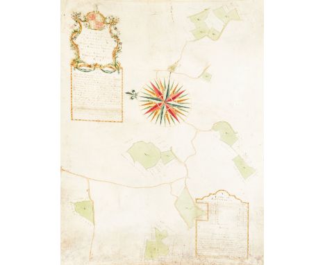
Romney Marsh, Kent.- A Map of several Pieces of Marsh Land lying in the Parishes of New Church Rucking: The Estate of Thomas Kingsley Esq., manuscript estate map with watercolour wash, on vellum, title and explanatory notes within 3 cartouches, soiled and creased, some slight surface wear, laid down on board, bowed, 780 x 550mm., 1765.
Australia.- White (John) Journal of a Voyage to New South Wales, first edition, engraved vignette title, 65 hand-coloured etchings, tissue-guards, later engraved map dated 1802 pasted inside upper cover, faint spotting to first and last few leaves, contemporary manuscript note with Italian translation to front free endpaper, contemporary vellum, red morocco spine label with gilt lettering, large 4to, J. Debrett, 1790.⁂ John White was the principal surgeon aboard the First Fleet during its voyage from Portsmouth to Botany Bay. Commanded by Captain Arthur Phillip, the First Fleet founded a penal colony in New South Wales, the first European settlement in Australia. This contains descriptions of the voyage as well as illustrating many Australian species of flora and fauna for the first time, such as the Australian green tree frog, Litoria caerulea, also known as White's tree frog.

Middle East.- Burckhardt (John Lewis) Travels in Arabia, 2 vol., engraved folding map and 4 plans, lacking half-title and final advertisement f., vol.1 map offsetting on to title, offsetting of plans, occasional spotting, modern morocco-backed marbled boards, spines faded, t.e.g., [Blackmer 239], 8vo, 1829.⁂ Burckhardt travelled to Mecca and Medina in 1814 disguised as an Arab Sheikh and through his extensive knowledge of Arabic and Muslim practices managed to avoid exposure.
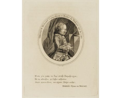
Americas.- Barrington (Hon. Daines) Miscellanies, first edition, 2 engraved maps, one folding, and 2 engraved portraits (one of the young Mozart, see below), lacking the genealogical tables, with contemporary manuscript note to p.151 concerning the origin of the turkey, browning to a few leaves and occasional water-staining to upper margins, 3O4 and 4B2 torn and defective at head (first with loss to pagination), contemporary speckled calf, spine gilt, rubbed, corners worn, joints split, [Hill 56; Sabin 3628], 4to, by J.Nichols, 1781.⁂ Covering a wide range of subjects but including 'Tracts on the Possibility of reaching the North Pole', 'Whether the Turkey was known before the Discovery of America', 'Account of Mozart, a very remarkable young Musician' with portrait of the young composer (the first published portrait, reprinted from Philosophical Transactions of 1770), 'History of the Gwedir family', 'Journal of a Spanish Voyage in 1775, to explore the Western Coast of N. America' with map. The latter is the first and only contemporary account in English of the first Spanish voyage into Alaskan waters. There is also much relating to Thomas Pennant.

Persia, Achaemenid Empire Æ14. Time of Artaxerxes III to Darios III. Uncertain mint (Ephesos?), circa 350-333 BC. Persian king or hero in kneeling-running stance right, holding spear and drawing bow; BA behind, c/m: eight-rayed star within circular incuse / Incuse punch with pattern depicting 'map of the hinterland of Ephesos (?)'. A. Johnston, 'The earliest preserved Greek map: New Ionian coin type', JHS (1967), 1-4; B; BMC Ionia 7; Traité II 79, pl. LXXXIX, 13; Klein 366. 2.15g, 14mm. Very Fine. Of considerable interest. From a private German collection. The relief areas of the incuse reverse type found on the reverse of this coin have been interpreted by Johnston (see references) as a relief map depicting the hinterland of Ephesos. If this interpretation is correct, this reverse type remarkably represents the earliest physical relief map known. The upper part of the incuse reverse depicts the Tmoulus and Messogis ranges divided by the valley of Caÿster. The rivers Hermus and Maeander are visible above and below the two ranges respectively. The lower part shows the two tributaries of the Maeander, the Harpasus and Morsynas, dividing the southern mountain block into three ridges.
![Gordian III Æ25 of Gadara, Decapolis. Dated CY 303 = 239/40 CE. [AYTOK K MAP ANT? ?OP?IANOC], laureate, draped and cuirassed](https://cdn.globalauctionplatform.com/cc715a7a-1b29-40c6-97b3-a99200b6cf28/c4218268-92e6-4614-bc25-a99300a44baf/468x382.jpg)
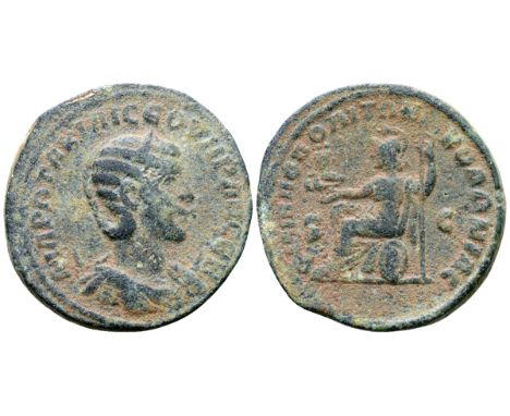
Otacilia Severa (wife of Philip I) Æ29 Philippopolis, Arabia. Struck at Antioch for circulation in Philippopolis, AD 247-249. MAP ?TAKI? C?OVHPAN C?B, diademed and draped bust right / ?I?I??O?O?IT?N KO??NIAC, Roma or Allat seated left on shield, holding spear and eagle, who supports two figures; S-C across fields. De Saulcy pl. XXIV, 4; Spijkerman 5; K. Butcher, “Two Related Coinages of the Third Century AD; Philippopolis and Samosata,” in INJ 9 (1986-7), 9. 19.79g, 29mm, 6h. About Very Fine; edge knock.


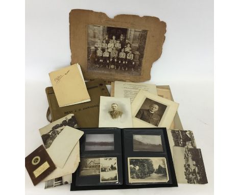
OF SPORTING INTEREST: A collection of Jack Parson Memorabilia to include an old khaki fabric map case inscribed to front, "Revd J.H. Parsons", together with a selection of old school and Military photographs, together with a folder of photographs and postcards (together with some negatives), of life in Pakistan and Bombay. Parsons was an old boy of Bablake School, Warwickshire Cricketer and Military hero. Est. £100 - £150.


A quantity of reports, booklets, magazines and other items to include The Kenya Settlers Cookery Book and Household Guides, Ministry of Aviation Photographic Study of the origin and development of fatigue fractures in aircraft structures, Land Tenure in Buganda, Townsmen in the Making Kampala and its suburbs and a framed map of East Africa
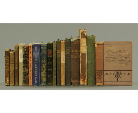
A box of 19th century and later books on The Lake District, poetry, etc., to include Rambles in The Lake Country by Edwin Waugh (1861), The Complete Guide to The Lakes (1842), A Description of The Scenery of The Lakes (1822), etc. (17). CONDITION REPORT: The Complete Guide to the Lakes is the 1845 version and has one folding map, it has a loose flyleaf and split spine. Voices from the Lakes and other poems by C.D. Bell 1877 has damage to spine. Rambles in the Lake Country 1882 by Edwin Waugh, with map and illustrations. Scenery of the Lakes 1842, cut to title page, spotted boards, map to back of book. English Lakes by Jonathan Otley 1833, with map. Poems by General Henry Wyndham of Cockermouth Castle 1856, Rambles of the Lake Country by Edwin Waugh 1861. Blacks Guide to the Lakes. Priors Guide to the English Lakes with maps (ex library). Scenery of the Lakes by William Wordsworth 1822, with map rebound. The Old Man 1849, with tear to title page.
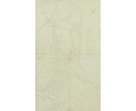
A town plan of Keswick, dated 1852, Shewing (sic) the present state of the drainage, lighting, water supply... Footnote: this map was produced for the Company Robert Rawlinson's report to the general board of health on the town of Keswick and notes that number 10 is owned by Edward Barron, is two private dwelling houses with one pump and one privy; the privy is common to both tenements, folded in quarters, mounted and framed, 70 cm x 42 cm.


-
109198 item(s)/page