We found 109198 price guide item(s) matching your search
There are 109198 lots that match your search criteria. Subscribe now to get instant access to the full price guide service.
Click here to subscribe- List
- Grid
-
109198 item(s)/page


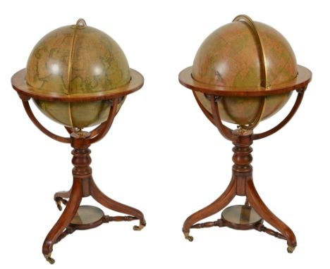
Lot 510
A fine pair of Victorian 18 inch floor-standing library globes J A fine pair of Victorian 18 inch floor-standing library globes J. Wyld, London, mid 19th century The terrestrial applied with twelve hand coloured printed gores and applied paper label A TERRESTRIAL GLOBE, Compiled from the latest, & MOST AUTHENTIC SOURCES, including all the recent, Geographical Discoveries, PUBLISHED BY J. WYLD, Charing Cross East, NEXT DOOR TO THE POST OFFICE, LONDON to North Pacific and extensively annotated with principal cities, towns, rivers, lakes, mountains and other significant topological features and with the British colonies colour-outlined in pink, the oceans with 'lines of Variation' and all notable islands annotated, as well as other commentary such as Yedo the Capital of Japan contains 1200,000 inhab'ts and is the residence of the Koubo or Seular Emporer, Meaco or residence of the Mikado or Spiritual Emperor contains 500000 inhab'ts and 6000 Temples, the Pacific with an analemma for the equation of time over table entitled TABLE OF THE ESTIMATED POPULATION OF THE WORLD.., by G.S. Brent Fellow of the Statistical Society of London , the equatorial line graduated in degrees, hours and minutes, the Celestial of conforming construction and labelled A, CELESTIAL GLOBE, Exhibiting the whole of the, Stars, Contained on the Catalogues of, PIAZZI, BRADLEY, HEVEHNS, MAYER, LA CAILLE & JOHNSON, the Double Stars from Sir W. Herschel and Struve, PUBLISHED BY J. WYLD, Charing Cross East, NEXT DOOR TO THE POST OFFICE, LONDON to lower hemisphere beside scale for star intensity and other explanations, the solstitial and equinoctial colures and equatorial graduated in degrees with the latter also in hours and minutes, the constellations depicted by mythical beasts and figures and appropriately labelled along with the stars in Latin, both spheres with engraved hour dials to poles and pivoted within brass meridian circle divided for degrees, resting in wooden stand with hand coloured paper horizon ring graduated in degrees in two directions, days of the month and houses of the Zodiac with names and symbols and also showing compass directions, supported on four curved quadrant supports to a baluster turned upright issuing three downswept supports with compass supported via three turned stretchers between, the feet with tapered brass cups and castors, 58.5cm (25ins) maximum diameter, 107cm (42ins) high. James Wyld (II) is recorded in Clifton, Gloria Directory of Scientific Instrument Makers 1550-1851 as a globe maker, map publisher and geographer who worked from several addresses in London including 454 West Strand (1837-1887), 454 Charing Cross East (1841-2), 2 Royal Exchange (1851) and Leicester Square (1848).
Lot 156
WALPOOLE, George Augustus: The New British Traveller or, A Complete Modern Universal Display of Great Britain and Ireland. L, Alex Hogg, nd, (Frontis dated 1794). Revises, corrects and Improved by W.H.Dalton. Folio, with many full page plates. CONDITION: Lacking the map and some plates; covers worn and detached. Sold as a collection of plates, with all faults


Lot 781
A map of the Parish of Hasketon in the County of Suffolk, surveyed by Dixon and Maitland 1838, copied by J Mc Lachlan, Stowmarket, signed by the Asst. Tithe Commisioner, "Martin", Also signed by two Tithe Commisioners and sealed, Approx 72" x 72" the map is backed with linen and contained in a metal tube, which while being externally rusty, has preserved same very well


Lot 702
Family group of medals, ephemera and related items comprising Great War pair of Medals to 2nd Lieutenant Andrew Smith, King's Own Scottish Borderers, British War Medal and Victory Medal + Field Message Book (Army Book 153), with pencil signature of Andrew Smith and various pencil entries, the cloth cover with pencilled signature of a Captain C Coy, 2nd Batt NZRB with some notes re munitions etc handed over to the Company in April 1918, + Army Book 133 with lists of soldiers in 7 Platoon and with names of casualties crossed out + Field Service Pocket Book + booklet entitled "Prominent Landmarks opposite 2nd Army Front", pub 2nd Army Intelligence Sept 1918 +Message Forms No 9674 with internal double page map "Trenches corrected from information received up to 21-9-18" [Zillebeke to South West, Zonnebeke to North East] + various maps on linen, Germany Sheets 1K, 2K, 1L, all pub Nov 1918, scale 1:100,000; Belgium (Brussels) ND scale 1:100,000; Belgium Sheet 29 NE edition 3, pub 1916 scale 1:20,000; Belgium and France Sheet 29 edition 3 pub May 1917 scale 1:40,000, France Sheet 36 A edition 6, pub December 1917 scale 1:40,000; Belgium Sheet 29 NE Provisional issue edition 3A (local) pub 18-10-18, scale 1:20,000; Belgium Sheet 3 D edition 2 pub September 1918 scale 1:40,000; Ypres edition 3 B (local) pub 15-7-18 scale 1:10,000 + four other paper maps; Lys Valley pub 31-12-17 scale 1:40,000; Passchendaele Ridge pub 1-1-18 scale 1:40,000; Belgium Sheet 21 NB edition 3 B (local) pub 15-10-18 scale 1:20,000 + one other map + some pages from "The Scotsman" Feb 20 1920 with announcement Second Lieutenant A Smith to be a Lieutenant 18th Oct 1919 + WW2 Group of five medals to Sgt Andrew C Smith 1939-45 Star, France and Germany Star, Defence Medal, War Medal, Police Long Service and Good Conduct Medal (QEII), + set of miniatures both mounted as worn + Portsmouth City Police Helmet plate, badge and button + Royal Life Saving Bronze Medal to A C Smith dated May 1942 + St John Ambulance Association Medallion to Andrew C Smith + 1948 Year Bar and Badge + sundry other items including German Great War Iron Cross, pair of Great War period S4 L6483 binoculars cased, Great War period Military Issue Compass, Verner's pattern 8 No 91121 dated 1917 in leather case, stamped "C & R Brinsley 1916" etc


Lot 598
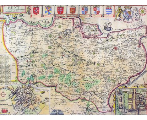
John Speed (1552-1629) - Coloured engraving - Map - "Kent with her Cities and Earles described and observed" with plans of the Cities of Canterbury and Rochester and seven armorials, complete with Royal Arms, 14.75ins x 19.5ins, thought to be first edition, engraved by Jodocus Hondius, Amsterdam, 1611, framed and glazed to both sides


Lot 294
Associated Motorways Day & Night Express Services enamel Sign. Depicts a map of mainline UK in yellow and black with an early 1950's coach behind showing 'Express London to Swansea headcode. At the bottom there is the address of Head Office at the Coach Station Cheltenham Tel 3067. Measures 30.5in x 20in and is in extremely good condition with only minor chips around a few bolt holes.


![[HUNTING] A folding Fox Hunting Map of Essex, published by J. & C. Walker, London, circa 1860, hand outlined in colour, linen](https://cdn.globalauctionplatform.com/17d40fbf-f532-465d-a176-a45b00b78ed4/ac31612c-d9ba-4f6c-be85-e8ca4228f7a3/468x382.jpg)
![[HUNTING] A Heythrop Hunt pocket map book, laminated pages, 16cm x 12cm.](https://cdn.globalauctionplatform.com/17d40fbf-f532-465d-a176-a45b00b78ed4/e112b5e8-9f6c-499d-b6df-a0406325f6a8/468x382.jpg)
![[HUNTING] Masser's folding Hunting Map of the Bramham Moor District, 1885, colour printed, linen-backed, black leather gilt,](https://cdn.globalauctionplatform.com/17d40fbf-f532-465d-a176-a45b00b78ed4/2eafd901-d31c-42d2-af8a-c48ce46e012e/468x382.jpg)


Lot 319
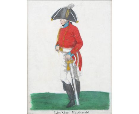
A PAIR OF LATE VICTORIAN OVER PAINTED PORTRAIT PHOTOGRAPHS, the gilt gesso frames with 'C' scroll and foliate ornament to the corners, inner mounts, sight size 19 x 14cm (arched); a spy print - 'The Revd George Charles Bell'; an engraving - 'Lieut. Gen Macdonald' in the manner of Dighton; a map after Christopher Saxton; and a print of the Long Room at Lords after Hanslip Fletcher (6)
-
109198 item(s)/page