We found 109198 price guide item(s) matching your search
There are 109198 lots that match your search criteria. Subscribe now to get instant access to the full price guide service.
Click here to subscribe- List
- Grid
-
109198 item(s)/page


Lot 608
ROWE, Nicholas, Translator, Lucan's Pharsalia 2nd Ed. London 1722 with dedication by Anne Rowe, 10 books in 2 vols. with folding map of the Roman Empire and engraved frontispiece after Cheron, London 1722, contemporary full tooled calf with red morocco title, 8vo. (160 x 100mm) Eric Gerald Stanley b/p (2)

Lot 552
TROIL, Uno Von, 'Letters on Iceland Containing Observations...made during a voyage undertaken in the Year 1772 by Joseph Banks Esq...', printed in London 1780 with fold out map and engraving of a geyser, full calf, restored black title, 8vo. (215 x 135mm) plus Northern Antiquities or a Description of the Manners, Customs Religion and Laws of the Ancient Danes. 2 vols. London 1770, full calf splits and bumps. 8vo. (213 x 140mm), each with b/p for John Lewis Boissier and Eric Gerald Stanley (3)


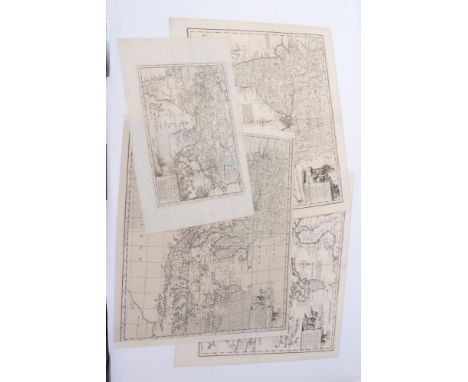
Lot 947
JOHN STOCKDALE (PUBLISHER) A George III large Atlas entitled 'A General Map of The Empire of Germany, Holland, The Netherlands, Switzerland, The Grisons, Italy, Sicily, Corsica and Sardinia by Captain Chauchard etc' dedicated to George III, London 1800 with 25 maps/plates Fo. water damage throughout


Lot 543
LAMBARD, William (1536-1601) English Antiquarian, A Perambulation of Kent, 1st Ed. title with typographic border, full page map, slight cut of Heptarchy, London Ralphe Newberie 1576, old rebind with marbled end papers, full brown calf with red title, losses to spine, bumps etc. 4to. (179 x 130mm), Eric Gerald Stanley b/p
Lot 605
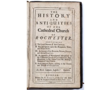
RAWLINSON, Richard (1690-1755) (Attrib.) The History and Antiquities of the Cathedral Church of Rochester, Curll London 1717, notes on end papers. 8vo. full calf, red title, scuffed and bumped plus GENT, Thomas, History of The Loyal Town of Rippon with numerous engravings and folding map, London 1733. 8vo. tooled leather with red title plus GORHAM, George C., The History and Antiquities of Eynesbury and St Neotts.... London 1824, 2 vols. marbled boards. 8vo. Eric Gerald Stanley b/p (4)

Lot 120
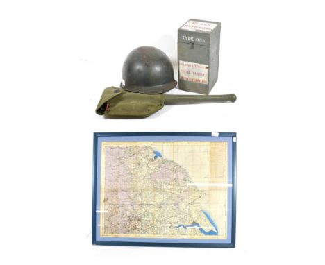
A Second World War US Entrenching Tool, painted green, the blade stamped US/WOOD/1944, with green canvas case stencil marked J.A.SHOE/1944; a US Army Combat Helmet, with fibreglass liner and webbing chin strap; a Second World War Bomber Crew Hand Held Compass Type 06A, numbered 46941H, in original wood case; ; a Second World War RAF Aeronautical Map of England, North East, second edition, 55cm by 73cm, in a glazed frame (4)
Lot 70
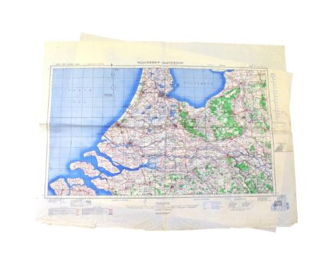
A Collection of Approx. 90 Second World War Military Maps, comprising: a part run (consecutively numbered 1-40) of German maps, England and Wales, 1:100,000 scale, marked, ''Sonderausgabe: Nur fur den Dienstgebrauch'' (Special Edition: for Service Use Only), circa 1938; a similar part run (consecutively numbered 1-34) of German maps of Scotland; a two-sheet map, Antwerp V1 & V2 Attack: Fall of Shot on Arrondissement of Antwerp from 7 Oct. '44 to 30 March '45; a set of four German military maps, ''Stadtplan London'', 30.XI.41, 1:20,000 scale; six Allied Army / Air maps, 1st. & 2nd. Editions, 1943 & 1944, comprising mainly German cities, 1:250,000 scale, and a small quantity of others, various. Mostly in folded but good condition. A few with tears or sellotape repairs.
Lot 148
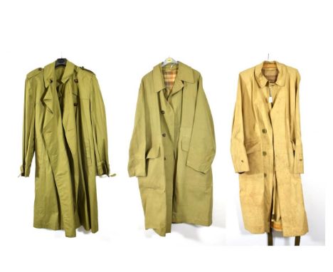
A Second World War British Army Rubberised Mackintosh, with tartan half lining, waterproof lined cuffs, each underarm with ten brass rivetted air vents, horn buttons, two large map pockets with flaps, with buckled belt, the inner flap bears traces of paper label; a Similar Rubberised Mackintosh by Alkit, London, with sealed seams and internal leg straps; a British Officer's Green Cloth Raincoat, with leather football buttons and leather bound buckles, with label ''Piccadilly, KL 1966 51 TC.31.6194.13'' (3)''


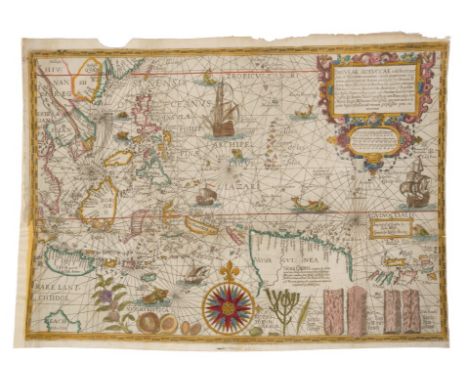
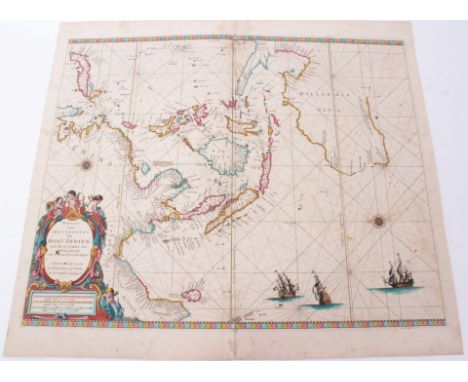
Lot 751
Jan Huygen Van Linschoten (1563-1610), hand-coloured map - ‘Insulae Moluccae’ 1598, ‘imprinted in London by John Wolfe, graven by Robert Beckit’, 36cm x 52cm, From John Wolfe’s 1598 pirated version of Linschoten’s influential ‘Itinerio’.Condition report: large horizontal patch top rear along fold 1/3 up from bottom, some overpainted elements, map appears to have a horizontal repair along the entire length, a gap closed and has been matched up along this repair and some elements lost to left hand side small hole at tip of Guinea. another large patch runs down rear of left side, there are some slight losses to left side, elsewhere some losses to margins, patch to top right corner arresting tears, some stains, creases


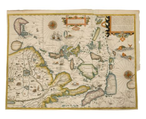
Lot 752
Jan Huygen Van Linschoten (1563-1610), hand-coloured map - ‘Exacta & Accurata Delineatio cum Orarum Maritimarum tum Etiam Locorum Terrestrium quae in Regionibus China, Cauchinchina, Camboja sive Champa, Syao, Malacca, Arracan & Pegu...’ the first published map of the Far East to be derived from Portuguese sources. Thus it is credited with breaking the Portuguese monopoly on the East Indian trade and was among the most important sources of information on Southeast Asia during the 16th century. ‘Henricus F. Ab Langren Sculptit’, 1595, 39cm x 52cmCondition report: Large patch repair to tear which runs across top right corner, some associated deteriorations and restorations, much of the margins lost, otherwise some stains but generally ok


Lot 717
Emanuel Bowen (1720-1767), four engraved maps - ‘East Indian Islands’; ‘East Indies’; ‘Empire of Great Mogul’; ‘A Map of Marco Polo’s Voyages and Travels in the 13th Century’, mid-18th century, the first three approximately 35 x 43cm, ‘Marco Polo’s Voyages’ 20 x 30cm. (4)Condition report: East India Islands- patch repair to foot of spine, minor time stains East Indies - \finished in tape to both left and right sides slightly beyond plate mark, otherwise ok Mogul Empire - large brown stain centre right, tape repair to spine, minor disrepair Marco Polo- tapa repair arresting tear to lower edge otherwise ok


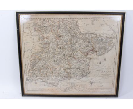
Lot 796
Carrington Bowles hand-coloured engraved map -‘New pocket map of the County of Essex, 49 x 54cm, glazed frame, together with John Ogilby hand coloured engraved road map - London to Yarmouth, Thomas Kitchin map of Suffolk, Mercator Hondius miniature map - ‘Essexiae Descriptio’ and Peter Andre ‘Plan of Colchester’. (5)


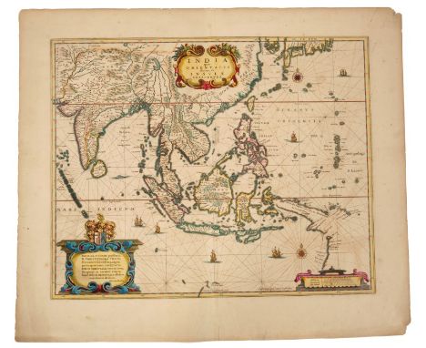
Lot 722
Giovanni Maria Cassini (18th century), hand-coloured map - ‘Le Indie Orientale’, dated 1797, 36cm x 49cm, together with another - ‘Le Isole Della Sonda, Moluccan, E Filippine’ (2).Condition report: Orientale - water stain from top edge, some general time staining Le Isole... - strengthened at spine, a small worm hole centrally, general time-staining

Lot 767
John William Norie (1722-1843), engraved map - ‘A new chart of The Straits of Malacca and Singapore’, published 1820, 62cm x 92cm.Condition report: Some staining particularly at periphery including water staining at lower edge and at folds, some tears at folds, some of which have been arrested with tape, no severe damage

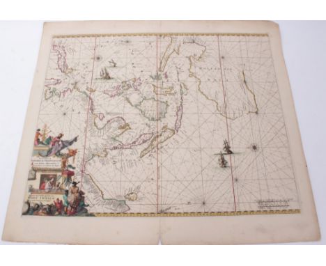
Lot 708
Jean Baptiste Nicolas Denis Apres de Mannevillette (1707-1780), hand-coloured chart - ‘A Chart of the East Indian Islands....’, dated 1778, printed for R. Sayer & J. Bennett, map and sea-chart sellers, No. 53 Fleet Street, 51cm x 89cmCondition report: Central fold, margins intact, a few stains and grubby areas but overall good condition

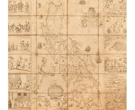
Lot 790
Pedro de Murillo Velarde (1696-1753), engraved map - ‘ Carta Hydrographica y Chorographica delas Yslas Filipinas Dedicada al Rey Nuestro Señor Por el Mariscal d Campo D. Fernando Valdes Tamon Cavallº del Orden de Santiago de Govor. y Capn. General de dichas Yslas‘, ( The Murillo Velarde Map), engraved by Nicolás de la Cruz Bagay, published Manilla 1734, title cartouche at the top with the Royal Bourbon coat of arms, supported by two cherubs with trumpets, the title on a cloth held by two female allegorical figures bearing charts and instruments for navigation. A further ornate cartouche below, surmounted by a crowned lion wielding a sword and a candle, contains a brief history of the archipelago starting with Magellan's arrival and death in 1521, a description of the resources: ‘These islands are numerous and rich: they have gold, wax, sugar, honey, tobacco, ginger, indigo, Brazil wood (sibucao), pitch, rice, salt, wheat, maize, lemons, oranges, bananas and many fruits and edible roots, palo Maria, tamarind, cassia-trees, Catbalogan seeds, dragon blood, lignum vitae, coconuts, bamboos, rattan and many kinds of palms, mahogany, tindalo and excellent timber for ships: horse, caraboas or buffaloes, cows, pigs, deer, chickens and much fish.’ There follows a description of the settlements, peoples, clergy and administration, all above an engraving of his ship the Victoria. The map is dissected and re-mounted on linen, 111cm x 120cm, early pen inscription verso - ‘map of the Philippine Islands’, folding map in later slip case. An extremely rare map and believed to be one of only around 15 extant examples of this first edition - the majority in International Institutions, and not all examples retain the flanking vignettes. Cited as the first scientific map of the Philippines and considered the most important Philippines map, it is celebrated for its detail and accuracy, it features shipping routes for trade with China and charts the course of Magellan’s navigations. The map features twelve flanking vignettes encapsulating the essence of the Philippines, depicting different ethnic groups, customs, flora and fauna, also featured are miniature maps of Guajan (Guam), Manila, Samboangan and Cavite , all extensively annotated. The map influenced all subsequent Philippine maps for decades to follow but its influence was also notable on European maps. In recent times The Murillo Velarde map has been instrumental in the Philippines' efforts to assert territorial rights in the South China Sea. The map, together with others was used by the Philippines' team of experts to refute China's historic claim of ownership of the entire South China Sea. It features ‘Panacot’ (Scarborough Shoal) as well as ‘Los Bajos de Paragua’ (Spratly Isles). In 2016 the Permanent Court of Arbitration ruled in favour of the Philippines stating that China had "no historical rights". China however, rejected the ruling. Provenance: Purchased from the map dealer Susanna Fisher, 1986 for £4,500. She had acquired the map from a trade source some years before and prior to that the map was believed to have been in private hands in the U.K. She states in correspondence that the ancient pen inscription in English to the reverse suggests that this map has been in the U.K. for a very long period of time,Condition report: Each corner has evidence of drawing pin holes with associated damage / slight losses, tear to the paper top left corner (prior to mounting on canvas), generally some staining towards periphery of each panel, particularly to central panels, and slight losses at margins of certain panels, conservation repairs and patching to canvas (patching at several of the folds) tonally the paper and ink is consistent throughout, some small tears at folds of canvas, generally some time staining and deterioration commensurate with age, no severe damages. Overall colour is yellowed somewhat but largely consistent throughout, some repair to canvas particularly at folds, detrioration to outer edges of each panel, staining to outer edges particulate to central two rows. Most of the maps is in good mostly original condition almost all of the printed element present, More specifically - Left row, top panel: damage and small losses top left corner, a tear runs diagonal from side upwards above printed element, stains at periphery, small tears at left side Left row, second panel: stains lower right, top right corner and lower edge, minor marks left row, third panel:small losses top left corner, minor deterioration upper edge, stains top right corner left row, fourth panel:some staining to corners, repair to canvas beyond lower right corner l;eft row, Fifth panel:slight loss top left corner, couple of fox masks, brown stain far right in map section, stain top right corner, small tear to canvas beyond lower right corner Left row, sixth panel: Some damage and small losses to printed element lower left corner, staining to left edge, Second row, top panel:stains left and right edges, canvas repair beyond top left corner, canvas tear beyond lower right corner, stains Second row, second panel: staining to corners, small tear to can vas beyond lower right corner Second row, third panel:staining to corners Second row, fourth panel: staining to corners, small tear beyond lower right corner, Second row, Fifth panel: staining and some slight deterioration to corners, small tear to canvas beyond lower right corner, Second row, sixth panel: some slight losses/deterioration lower right corner/ top right corner, brown staining around area of ship-Victoria Third row, top panel:some deterioration slight losses to corners, staining to corners, repair to canvas beyond lower right corner Third row, second panel:staining to corners, minor blemishes Third row, third panel: staining to corners, repair to canvas beyond lower right corner, Third row, fourth panel: minor stains lower right corner, repair to canvas beyond lower right corner Third row, Fifth panel: minor staining to periphery, repair to canvas beyond lower right corner, Third row, sixth panel:staining to left edge, top right corner, detrioration to lower left corner Right row, top panel: some small losses top right corner, bottom right corner, and deterioration lower edge, staining to periphery Right row, second panel: minor staining to right edge, minor blemishes, Right row, third panel:minor staining to right edge, Right row, fourth panel:staining to right edge, element here above the image top edge is a separate piece of paper and slightly misaligned, continues horizontally across the map, presume this is reflecting how the map was printed and presented before division and mounting rather than a replaced element. Right row, Fifth panel:staining right edge, slight losses lower right corner, repair to canvas beyond lower right corner, Right row, sixth panel: staining slight damage left edge, losses lower right corner, slight loss top left corner, blemishes


Lot 721
John Cary (c. 1754-1835), hand-coloured map - ‘A New Map of the East Indian Isles’, dated 1801, 49cm x 55cm, together with the 1811 edition of the same map and ‘A New Map of Asia’, 1806 (3).Condition report: 1801 map good 1811 map repairs to spine, creases and deterioration to margins New map of Asia 1806 - minor stains, basically good

Lot 604
Billingsley John, 'General View of the Agriculture of the County of Somerset in the year 1795', second edition, Bath 1798, half title, folding map frontis, one plat,e another folding map, marbled boards, half leather, rebacked, Kent Nathaniel ' General View of the Agriculture of the County of Norfolk...' printed at the Norfolk Press, 1796, folding map frontis, three plates, one folding, marbled boards, half leather, uniform with previous vol. [ John Holt ] 'General View of the Agriculture of the County of Lancaster ...' printed for G Nicol Pall Mall 1795, folding map frontis, folding and other plates, marbled boards, rebacked, Bailey J and Culley G ' General View of the Agriculture of the County Northumberland ...' London printed by B McMillan etc 1805, folding map frontis, plates some folding and including Cumberland and Westmorland , rebound, marbled boards, half leather, Home John ' Rectified Report of Berwickshire Agriculture...' Berwick published by and sold for the author 1797, folding coloured map, bound uniform with previous volume, Pitt W. ' General View of the Agriculture of the Country of Stafford...' printed for G Nicol Pall Mall 1796, plates folding map, folding plan, marbled boards, half leather and another vol (7)


Lot 702
John Speed (1552-1629), hand-coloured map - ‘Cambridgshire’, published Bassett and Chiswell, dated 1610, with armorial shields of the Colleges and vignette map of Cambridge, 39cm x 52cm, framedCondition report: Glazed frame and not examined out of frame, mounted to edge and no margins exposed, appears to be in good overall condition

-
109198 item(s)/page