We found 109182 price guide item(s) matching your search
There are 109182 lots that match your search criteria. Subscribe now to get instant access to the full price guide service.
Click here to subscribe- List
- Grid
-
109182 item(s)/page


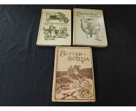
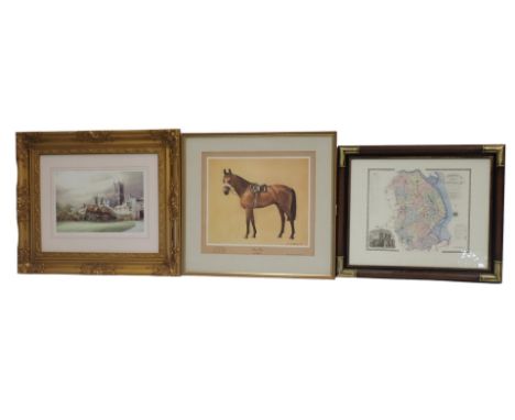
Lot 14
SIR EDWARD ABBOT PERRY: 3 Titles: BUTTERSCOTIA OR A CHEAP TRIP TO FAIRYLAND, Ill Archie MacGregor, London, David Nutt, 1896 first edition, frontis folding map, 12pp adverts at end, inscription on ffep, original pictorial cloth, THE FIRST BOOK OF KRAB CHRISTMAS STORIES FOR YOUNG AND OLD, Ill Archie MacGregor, London, David Nutt, 1897 first edition, frontis, 12pp adverts at end, original pictorial cloth, KATAWAMPUS ITS TREATMENT AND CARE, Ill Archie MacGregor, London, David Nutt, 1898 third edition, 7 plates as list, original pictorial cloth (3)


Lot 80
THE UNIVERSAL MAGAZINE OF KNOWLEDGE AND PLEASURE..., London, John Hinton, 1760, vol 27, engraved title frontis and 18 plates, maps etc as list including 2 coloured plates "The Rhinocerus Beatle" and "The Chinese Quail", folding map of Warwickshire, coloured folding map of all the countries bordering on the eastern parts of the Mediterrean Sea, coloured folding map of the east part of England, 2 folding perspective views of the city of Coventry and Warwick Castle, some folding plates with splits at folds, folding plan of Battle of Suptitz with part loss at right margin, contemporary calf worn, spine gilt in compartments


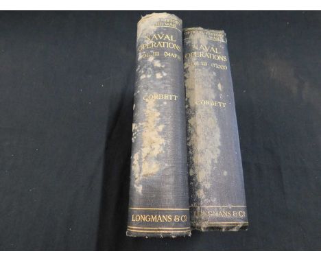
Lot 209
SIR JULIAN STAFFORD CORBETT: HISTORY OF THE GREAT WAR BASED ON OFFICIAL DOCUMENTS..., Naval Operations Vol 3 [Events from the Spring of 1915 to the Battle of Jutland], London, Longmans Green, 1923 first edition, 2 vols including map vol, plans, diagrams and plates collated complete, original cloth very soiled (2)


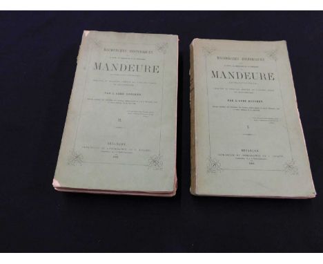
Lot 299
EUGENE AUGUSTIN BOUCHEY: RECHERCHES HISTORIQUES SUR LA VILLE LA PRINCIPAUTE ET LA REPUBLIQUE DE MANDEURE (EPOMANDUODORUM) ORIGINES ET HISTOIRE ABREGEE DE L'ANCIN COMTE DE MONTBELIARD, Vesancon, J Jacquin, 1862 first edition, 2 vols, engraved folding frontis map, part unopened, original printed wraps, text block weak (2)


Lot 124
Falklands War very large operations contour map, with few annotated notes, folded, rolled and taped together. One of only eight sets of this map to exist. The markings on the map showing the start points for attacks and line of advance across the Island complete with code words. The map belonged to Scott Ward (LCoH), Scimitar Commander. (See also lots 123, 125, 126 & 127.)
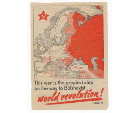
Lot 187
'This war is the greatest step on the way to Bolshevist world revolution!' Second World War German airborne Propaganda leaflet. Double sided leaflet, front depicts the creeping of red territory over the map of Europe represented by crosshatched lines over various countries. Reverse reads 'Britain fights - Bolshevism marches on!' listing the spread of Russian Bolshevism through various locations. 'What did Stalin say? "This war is the greatest step on the way to Bolshevist world revolution!,,' 14.5cm x 20.5cm.


Lot 198
CLASSIC MALTS MINIATURE COLLECTION INCLUDING LAGAVULIN 16 YEAR OLD WHITE HORSE Cragganmore 12 Year Old - 40% ABV / 5clDalwhinnie 15 Year Old - 43% ABV / 5clGlenkinchie 10 Year Old - 43% ABV / 5clOban 14 Year Old - 43% ABV / 5clTalisker 10 Year Old Map Label - 45.8% ABV 5clLagavulin 16 Year Old White Horse - 43% ABV / 5cl

Lot 92
CLASSIC MALTS MINIATURE COLLECTION SINGLE MALT Cragganmore 12 Year Old - 40% ABV / 5clDalwhinnie 15 Year Old - 43% ABV / 5clGlenkinchie 10 Year Old - 43% ABV / 5clOban 14 Year Old - 43% ABV / 5clTalisker 10 Year Old Map Label - 45.8% ABV 5clLagavulin 16 Year Old White Horse - 43% ABV / 5clCragganmore 12 Year Old has lost approximately 2/3 of its volume to leakage.

Lot 314
A SILVER GILT PEACE NEGOTIATIONS AT GERTRUYDENBURG MEDALLION NORBERT ROTTIER (CIRCA 1665 – 1727), STRUCK 1710 obverse bust of Prince James facing right in armour with legend CVIVS EST, the revere with map of Great Britain and Ireland with ships around and motto REDDITE in banner above Dimensions:38mm diameter, 16.8g Provenance:Provenance: Property of a Gentleman – Previously from the collection of Sir Colin MacRae (1869-1952) of Feorlinn and Lady Margaret Crichton Stuart (1875-1964) Note: References:Woolf, N., 'The Medallic Record of the Jacobite Movement', item 23:1a Eimer, C., 'British Commemorative Medals, and their values', item 449aNote:This medallion, struck in 1710, shows the plans and hopes held by the Stuart exiled court. This medallion 5 years before the eventual invasion of 1715 was no doubt a key propaganda message. It is believed that this is the medallion from the contemporary account given by Abel Boyer which states ‘About this time, a medal was dispersed in the Netherland, the Chevalier de St. George’s Friends with the Prince’s head on the right side and the words CUIUS EST; and on the Reverse with Kingdoms of Great Britain and Ireland with this motto REDDITE. The medal was undoubtedly struck at this juncture, upon the hopes given by the Jacobites in England to their correspondents in France that the British Court and Nation were ready to invite the Pretender………. But whatever ground there was for such expectation, things were not yet ripe enough for the Pretenders Friends to throw off the Mask’


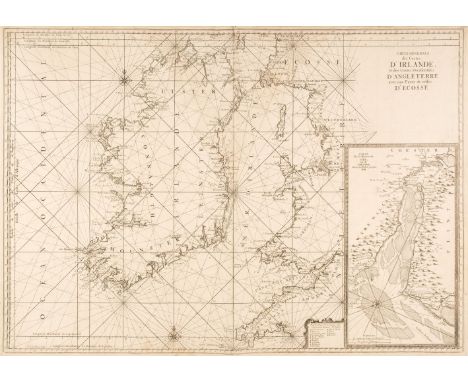
Lot 25
Ireland. Van Loon (Jan), Carte Generale des Costes D'Irlande et des Costes Occidentales D'Angleterre avec une Partie de celles D'Ecosse, [1661 or later], large uncoloured sea chart of Ireland and the west coast of England & Wales, inset map of the River Dee and Chester, compass rose and numerous rhumb lines, 610 x 870 mm, together with Beechey (Captain F. W. surveyor). The Irish Channel..., 1868, very large uncoloured engraved sea chart on two sheets not conjoined, numerous inset maps, old folds, slight wear where old folds cross, very slight staining, upper sheet 660 x 1000 mm, lower sheet 890 x 1000 mmQTY: (3)
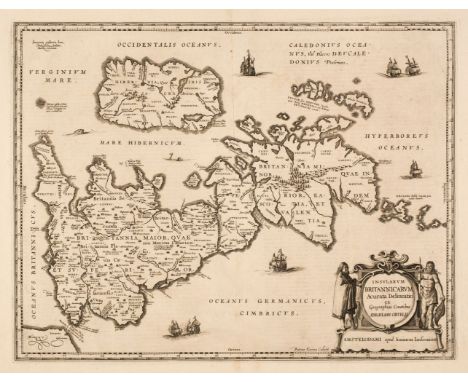
Lot 4
British Isles. Jansson (Jan & Ortelius Abraham), Insularum Britannicarum Acurata Delineatio ex Geographicis Conatibus Abrahami Ortelii, Amsterdam, circa 1642, an uncoloured historical map engraved by Pieter van den Keere, large margins, orientated to the west, very slight text show through, 395 x 510 mm, French text on versoQTY: (1)NOTE:R. W. Shirley. Early Printed Maps of the British Isles, 1477 - 1650, number 522.
![Newett (M. Margaret). Canon Pietro Casola's Pilgrimage to Jerusalem in the Year 1494, [Historical Series - No. V.], 1st editi](https://cdn.globalauctionplatform.com/87402b4b-4fbe-4970-a2f5-b05300bd7895/c63f421f-093d-4760-9506-b05401145640/468x382.jpg)
Lot 423
Newett (M. Margaret). Canon Pietro Casola's Pilgrimage to Jerusalem in the Year 1494, [Historical Series - No. V.], 1st edition, Manchester: University Press, 1907, monochrome frontispiece, folding map, some light toning, top edge gilt, original blue cloth, some minor rubbing to the head & foot of the spine, 8vo, together with:Zmora (Hillay), State and nobility in early modern Germany, the knightly feud in Franconia 1440-1567, 1st edition, Cambridge: University Press, 1997, original cloth in dust jacket, minor tear to thehead of the rear cover, 8vo, plusTanner (Marie), The Last Descendant of Aeneas, the Hapsburgs and the mythic image of the emperor, 1st edition, New Haven: Yale University Press, 1993, numerous monochrome illustrations, original cloth in dust jacket, cover lightly rubbed to head & foot, 8vo, andBayley (Charles C.), The Formation of teh German College of Electors in the Mid-Thirteenth Century, 1st edition, Toronto: University of Toronto Press, 1949, later inscription to the front endpaper, ex-library stamp & mark to the title page, some minor marginal toning, original cloth, 8vo, plus other modern & scholarly history reference, including university publications, mostly original cloth, many in dust jackets, G/VG, 8vo QTY: (6 shelves)

Lot 292
Sale (George, translator). The Koran, commonly called the Alcoran of Mohammed, 1st edition in English, London: C. Ackers for J. Wilcox, 1734, title printed in red and black, folding engraved map of Arabia by R.W. Seale, folding plan and view of Mecca on one sheet, 3 genealogical tables (2 folding), dedication leaves detached, water stains throughout, previous owner inscriptions to front endpaper, later half calf, rebacked with original spine relaid, a little rubbed with some edge wear, 4to QTY: (1)NOTE:ESTC T146975; Rothschild 1811. The first edition in English directly translated from the Arabic. There was a 1649 translation in English by Alexander Ross but this was taken from the poor French translation by Andre du Ryer in 1647.
Lot 12
England & Wales. Carington Bowles (publisher), Bowles's New and Accurate Map of England and Wales Comprehending all the Cities, Boroughs, Market and Sea-Port Towns, Villages, Lakes, Rivers, Forests, Ruins and Principal Seats of the Nobility; with the roads described by Daniel Paterson..., 1782, large engraved map on two sheets, sectionalised and laid on later linen. large decorative cartouche and compass rose, inset map of the Scilly Isles, some fraying to margins with slight loss, toned overall, some fraying with slight loss where old folds cross, some dust soiling and staining, overall size 1290 x 1010 mmQTY: (1)
![* Pigot (James). Pigot & Co.'s Map of England & Wales with part of Scotland [and] Pigot & Co,'s New Map of Scotla](https://cdn.globalauctionplatform.com/87402b4b-4fbe-4970-a2f5-b05300bd7895/0e818afc-81f9-4204-b742-b05401137b63/468x382.jpg)
Lot 46
* Pigot (James). Pigot & Co.'s Map of England & Wales with part of Scotland [and] Pigot & Co,'s New Map of Scotland with the latest Improvements, circa 1839, two engraved maps with contemporary outline colouring, old folds, each approximately 670 x 500 mm, uniformly mounted, framed and glazedQTY: (2)
Lot 27
Large Scale County Maps. A collection of 38 sheets from various maps, 18th & 19th century, large-scale engraved map sheets, many with contemporary hand-colouring, including examples from Benjamin Donne's map of Devon, Chapman & André's map of Essex, Andrews and Dury's Sixty-five miles round London, John Rocque's map of Berkshire, Hodskinson's map of Suffolk, Taylor's map of Gloucestershire and Armstrong's map of Lincolnshire, occasional duplicates, some sheets torn and frayed with occasional loss, a few sheets town along the central fold, various sizes and conditionQTY: (38)
Lot 239
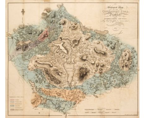
Griffith (Richard). Geological and Mining Survey of the Connaught Coal District in Ireland, Dublin: Graisberry and Campbell, 1818, hand-coloured engraved folding section (some offsetting) and hand-coloured engraved folding map with 8cm repaired closed tear to left-hand, manuscript number to upper margin of title, final leaf of text strengthened to upper margin, some light offsetting, toning and occasional spotting, edges untrimmed, modern cloth-backed boards, 8voQTY: (1)
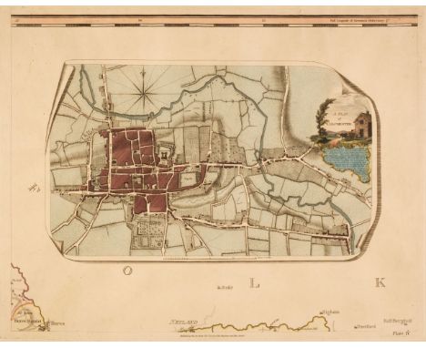
Lot 11
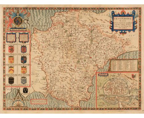
Devon. Speed (John), Devonshire with Excester Described and the Armes of such Nobles as have borne the titles of them, Thomas Bassett & Richard Chiswell [1676], hand-coloured engraved map, inset town plan of Exeter, slight toning and spotting, occasional marginal closed tears, one repaired closed tear affecting the printed image, central fold partially strengthened on the verso, 385 x 510 mm, English text on versoQTY: (1)

Lot 35
London. Weller (Edward), Civitas Londinum Ano Dni Circiter MDLX. London in the Reign of Queen Elizabeth, a facsimile (reduced) of the map by Aggas 1560, published Weekly Dispatch, circa 1865, uncoloured engraved panoramic map of London, sectionalised into four sheets and laid on linen, the right had section pasted onto a contemporary board, overall size 455 x 1235 mm, bound in contemporary half morocco boards with gilt title to the upper siding, spine partially detached and crudely repaired with old tapeQTY: (1)
Lot 32
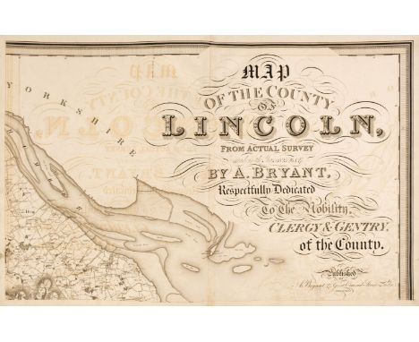
Lincolnshire. Bryant (Andrew), Map of the County of Lincoln from Actual Survey within the years 1825, 26 & 27..., Respectfully Dedicated to the Nobility, Clergy & Gentry of the County, April 19th 1828, large scale engraved map on eight double-page sheets, calligraphic title, compass rose, tables of explanation and divisions, engraved vignette of Lincoln Cathedral, some offsetting throughout, occasional small repaired marginal tears, each sheet approximately 530 x 815 mm, contemporary half sheep, lacking spine, boards detached, heavily worn and frayed, slim folio, binding size 585 x 465 mmQTY: (1)NOTE:The first and only edition of this large-scale map. Bryant produced 13 county maps very much in the style of the Greenwood brothers.

Lot 250
Shackleton (Ernest). South, The Story of Shackleton's Last Expedition 1914-1917, 1st edition, London: William Heinemann, 1919, colour and monochrome illustrations, folding map, usual toning and light spotting to textblock, original cloth, spine repaired at ends, spine lettering faded, upper cover illustration and lettering dulled, edges slightly rubbed, 8vo, together with:Shackleton (Ernest). The Heart of the Antarctic. Being the Story of the British Antarctic Expedition 1907-1909, 2 volumes, 1st edition, London: William Heinemann, 1909, photogravure frontispieces, colour and monochrome illustrations, 3 folding maps and a plate contained in volume II rear pocket, occasional light toning and marks, top edge gilt, original blue cloth blocked in silver, spines and extremities faded, volume I upper joint vertically split, some wear to other joints, 4toQTY: (3)

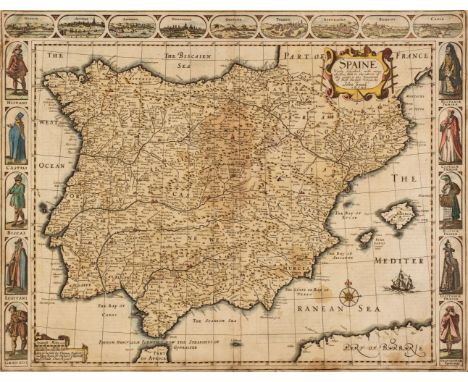
Lot 58
Spain. Speed (John), Spaine Newly Described with many adictions both in the attires of the people & the Setuations of their Cheifest Cityes by John Speed, Thomas Bassett & Richard Chiswell [1676], hand-coloured engraved carte-a-figures map with 10 vignettes of costumed figures to the vertical margins and 9 oval vignettes along the upper margin of principal cities, some marginal fraying and short closed tears, some staining, slight creasing, 420 x 540 mm, English text on versoQTY: (1)
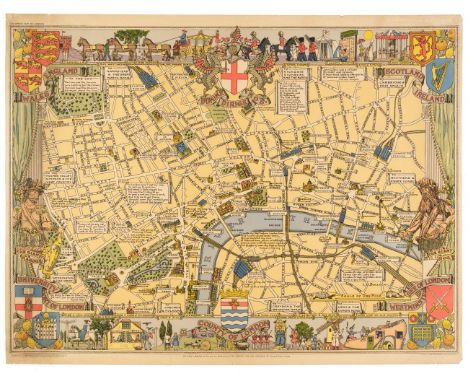
Lot 36
London. Bullock (L. G.). Children's Map of London, John Bartholomew & Son Ltd. Edinburgh, circa 1948, colour-printed pictorial map, slight marginal fraying, 540 x 725 mm, together with Clark (Estra). Historic York, Ben Johnson & Co. Ltd. 1947, colour-printed pictorial map, laid on later card, 540 x 660 mm, with Basire (J.). Plan of an Estate Belonging to the Crown, called Marybone Park Farm, upon a design for Letting it out on Building Leases [and] Plan of an Estate Belonging to the Crown called Marybone Park Farm, upon a Design for Letting it out on Building Leases by John Nash, Ordered by the House of Lords to be printed 12th June 1812, two engraved plans with contemporary hand-colouring, old folds, slight offsetting, 430 x 505 mm and 400 x 440 mm respectively, supplied with seven leaves of descriptive and explanatory text by John NashQTY: (4)
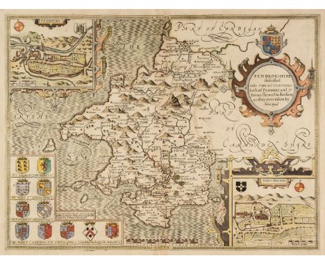
Lot 45
* Pembrokeshire. Speed (John), Penbrokshyre described and the Sittuations both of Penbroke and St. Davids shewed in due form as they were taken..., Thomas Bassett & Richard Chiswell [1676], hand-coloured engraved map, inset town plans of Pembroke and Saint Davids, large strapwork cartouche, 385 x 510 mm, mounted, framed and double-glazed, English text on verso, together with Blome (Richard). A Generall Mapp of South Wales..., circa 1673, hand-coloured engraved map, old folds, some spotting, 350 x 460 mm, mounted, framed and glazed, with Saxton (Christopher & Hole G.). Caernarvo. Comitatus pars olim Orovicum [1627], hand-coloured engraved map, large strapwork cartouche, compass rose and mileage scale, 255 x 310 mm, mounted, framed and glazedQTY: (3)

Lot 241
Johnston (Alexander Keith). The Royal Atlas of Modern Geography..., William Blackwood & Sons, Edinburgh, 1876, frontispiece of a map of the North Pole, title and dedication, 48 maps with contemporary outline colouring, slight spotting, all edges gilt, contemporary half morocco gilt, heavily rubbed and worn, folio, together with Hall (Sidney & Hughes William). General Atlas of the World..., Adam & Charles Black, Edinburgh, 1854, title and contents lists, sixty engraved maps with contemporary wash colouring, slight spotting, all edges gilt, contemporary half morocco gilt, rubbed and worn, folio, with Johnson (G. H.). The Handy Royal Atlas of Modern Geography..., W. & A. K. Johnston Limited, Edinburgh & London, 1912, frontispieces of maps of the North & South Poles, title, dedications and contents list, 58 colour printed maps, all edges gilt, contemporary half morocco gilt, rubbed and worn, folio, plus another defective copy with some maps excised, and Blackie (W. G.). The Imperial Atlas of Modern Geography..., Blackie & Son, London, Glasgow and Edinburgh, 1860, additional half-title, preface and contents, 100 engraved maps with contemporary outline colouring, some spotting throughout, all edges gilt, contemporary half morocco gilt, upper board near detached, lacking rear board, heavily rubbed and worn, folio, with another three atlases similar by Johnson, Bartholomew and Harsworth, various sizes and conditionQTY: (8)NOTE:Sold as a collection of maps, not subject to return.
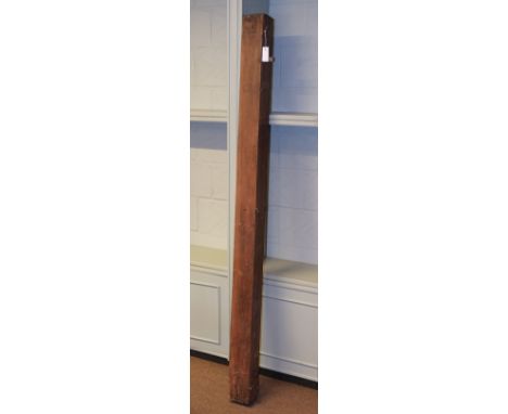
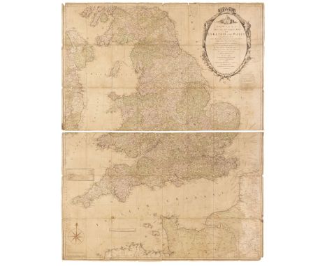
Lot 13
England & Wales. Cary (John), Cary's New Map of England and Wales with Part of Scotland..., June 11th 1791, engraved map with contemporary wash colouring, laid on linen, inset map of England & Wales, calligraphic title, some toning and marginal fraying and creasing (particularly to the lower margin, slight spotting and dust soiling, 2250 x 1750 mm, presented on a spring-loaded roller with a wooden batten (partially detached along the lower margin) and contained in a contemporary stained pine box with hinged lid, overall length 1990 mmQTY: (1)

Lot 379
Robertson (George Scott). The Káfirs of the Hindu-Kush, 1st edition, London: Lawrence &Bullen, 1896, numerous monochrome illustrations, previous owner inscription to the front endpaper, some light marginal toning & spotting, original red cloth, spine slightly rubbed to head & foot with some minor tears, 8voChitrál, The Story of a Minor Siege, 2nd edition, London: Methuen & Co., 1899, 32 monochrome illustrations plus a map & 4 plans, some light marginal toning & spotting, top edge gilt, original gilt decorated red cloth, spine lightly faded& rubbed to head & foot, 8vo, together with:Doughty (Charles M.), Travels in Arabia Deserta, 2 volumes, 3rd edition, New York: Boni and Liveright, 1921, monochrome illustrations, lacking folding map to the rear pocket, some gutters cracked, some light toning &spotting, top edges gilt, original uniform red cloth, spines faded, boards slightly marked & rubbed to head & foot, 8vo, plusBaden-Powell (B. H.), The Indian Village Community..., 1st edition, London: Longmans, Green, and Co., 1896, folding map with repairs, some marginal toning, ex-library copy with associated marks & stamps, original blue cloth, boards & spine slightly rubbed, 8vo, and other late 19th & early 20th century India & travel reference, some leather bindings, mostly original cloth, some odd volumes & ex-library copies, G/VG, 8voQTY: (3 shelves )

Lot 366
Sturge Moore (T.).The Centaur's Booty, London: Duckworth and Co., 1903, slight loss to the foot of the spineThe Rout of the Amazons, 1903, both with some light spotting, both in original wrappers, slim 8voThe Unknown Known and A Dozen Odd Poems, London: Martin Secker, 1909, later inscription to the front endpaper, some minor toning & spotting, original decorated cloth, 8voMariamne, 1911, some minor marginal toning, original illustrated boards, slightly rubbed, 8voThe Sea is Kind, 1st edition, London: Grant Richards, 1914, period inscription to the front endpaper, some light spotting throughout, top edge gilt, original gilt decorated blue cloth in dust jacket, covers rubbed toned & foot & slightly toned, 8voHark to These Three, Talk about Syle, London: Elkin Mathews, 1915, period inscription to the front endpaper, some spotting & light toning throughout, original illustrated wrappers, lightly rubbed to head & foot, 8voThe Powers of the Air, 1st edition London: Grant Richards, 1920, period inscription to the front endpaper, original boards, spine lightly rubbed & toned, 8vo, plus 4 further works by T Sturhe Moore, together with: Strachen (Walter), Poems, 1st edition, London: Christopher Hewett, 1976, engraved frontispiece by Charles Marq, signed by the author & artist to the limitation page, original cloth spine to blue boards & slipcase, 8vo, limited edition 139/180, plusRooke (G. H.), The Meghadūta of Kālidāsa, translated from the Sanskrit, Oxford: University Press, 1935, folding map frontispiece, some minor spotting, top edge gilt, original gilt decorated full vellum, boards lightly marked, 8vo, and other early to mid 20th century poetry, mostly original cloth, some in dust jackets, G/VG, 8voQTY: (5 shelves )
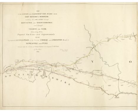
Lot 50
Road Maps. Telford (Thomas). Three Monumental road maps: Map of the London and Edinburgh Mail Roads from London to East Retford, including the two Lines to Alconbury Hill through Hatfield and Ware..., 1827, Map of the London and Edinburgh Mail Raods from East Retford to Morpeth including the two Lines through Doncaster and Boroughbridge and through Thorne and York..., 1826 [and] London and Morpeth Mail Road Index Map, Surveyed by Thos. Telford, printed at the Lithographic Establishment Quarter Master Gen.ls Office, Horse Guards, 1827, lithographic maps with contemporary outline colouring, the first described item on five sheets, torn with slight loss to the lower left corner of the first sheet, old glue marks to the margins where previously conjoined, each sheet approximately 475 x 670 mm, the second item on six sheets, old glue marks where previously conjoined, closed marginal tear on the left-hand vertical margin, each sheet approximately 470 x 605 mm, the third item on seven sheets, some dust soiling, occasional marginal closed tear with slight loss, each sheet approximately 660 x 500 mmQTY: (18)NOTE:Scarce monumental road maps on a scale of 2 miles to the inch.

Lot 44
* Oxford. Peele (Cecily), Map of Oxford's History: With some of its Worthies, The Alley Workshops, Oxford, circa 1934, coloured allegorical map, the vertical margins decorated with heraldic shields, the horizontal margins with caricatures of Oxford alumni stretching from a 'Stoneage Man' through to Lawrence of Arabia and Lord Nuffield, slight spotting, 475 x 515 mm, framed and glazedQTY: (1)NOTE:Uncommon.
-
109182 item(s)/page