We found 109198 price guide item(s) matching your search
There are 109198 lots that match your search criteria. Subscribe now to get instant access to the full price guide service.
Click here to subscribe- List
- Grid
-
109198 item(s)/page


Lot 169
A Collection of Mint and Used Stamps, Including 2 Guernsey Post Office Mint Stamps Books, Europa Great Works of Human Genius, Decimal Currency Definitive Issue 5p - 9p, A Mint Sheet of 120 4d Stamps World Cup 1966, A Stamp Sheet of 95 Cancelled Definitives 1/2p, 1p, 2p, 10p £1, A Mint Stamp Sheet from 1994 Republic Du Mali Featuring Clint Eastwood Pale Rider, A Mint Stamp Sheet with 9 Stamps from 2000 Kyrgyzstan Featuring Madonna, A Group of 5 Unused Postcards Featuring Famous Trains on Stamps 1985, A Map of Saint Vincent, Plus a Selection of approx 150 - 200 World Stamps. Good condition. All autographs come with a Certificate of Authenticity. We combine postage on multiple winning lots and can ship worldwide. UK postage from £4.99, EU from £6.99, Rest of World from £8.99


Lot 1782
19THC DISSECTED PUZZLES four 19thc boxed dissected puzzles, including Peacock's New Double Dissection (Whole Length Portraits of the Kings and Queens of England, and Critchley's Map of England and Wales on the reverse), Animals & Birds of the Bible (double sided, and with instruction sheet), Peacock Superior Dissected Maps, Europe (with instruction sheet), and Peacock's Super Double Dissection (Kings & Queens and England & Wales).See images online to see the completed puzzles. (4)

Lot 1938
SPORTING BOOKS including My Irish Sketch Book by Lionel Edwards (1938), My Hunting Sketchbook by Lionel Edwards (1928), and Osses and Obstacles (1935), The Unwritten Laws of Fox-Hunting by C F P McNeill, England & Wales The Fox Hunts folding map, Sir Alfred Munnings (An Artists Life 1950, The Finish 1952, The Second Burst (1951), History of the Forest of Exmoor by Edward T Mac Dermot, and 23 Vols by G J Whyte (Riding Recollections, Tilbury Nogo, The White Rose etc).


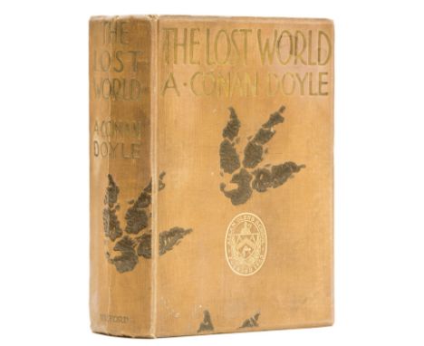
Lot 181
Doyle (Sir Arthur Conan) The Lost World, first edition, large paper copy, second issue, frontispiece and 12 mounted plates, 2 map illustrations, upper hinge starting, foxing to fore-edge, spotting to title, school prize bookplate to endpaper, original second issue brown cloth with dinosaur footprints stamped in darker brown, lettered in gilt, school prize gilt stamp to upper cover, central vertical crease to spine, spine ends and corners a little bumped, some marking and light surface soiling to covers, t.e.g., [Green & Gibson A37c], 8vo, [1912].
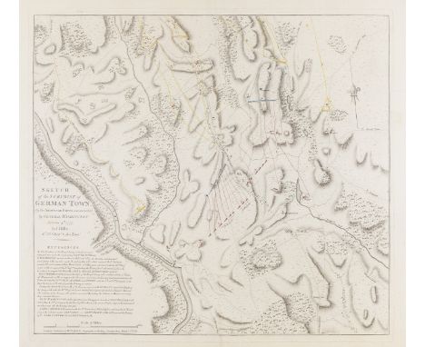
Lot 272
American Revolution.- Faden (William) & John Hills. Sketch of the Surprise of German Town, by the American Forces commanded by General Washington. October 4th 1777, from Faden's 'Atlas of Battles of the American Revolution', engraving with some hand-colouring of regiments and movement of forces, on laid paper with large Strasbourg lily watermark, with countermark 'R G' and 'X I', platemark 470 x 535 mm (18 1/2 x 21 in), sheet 570 x 750 mm (22 1/2 x 29 1/2 in), central vertical drying crease, full margins with some nicks to edges, marginal tear repaired to lower left edge, faint printers' creases, minor marginal surface dirt, unframed, 1784Provenance:Ex-collection of the Late James Stevens Cox F.S.ALiterature:Nebenzahl, Atlas of the American Revolution, no. 15⁂ "This map is a detailed topographical plan, generally conceded to be one of the best sources on the battle. On it are indicated the plan of attack and the disposition of the British and Hessian troops. The red and blue dotted lines and blocks indicate the British forces; the American columns are represented in yellow. A long list of references at the lower left gives additional data on the engagement" (Clements Library, quoted in Streeter).
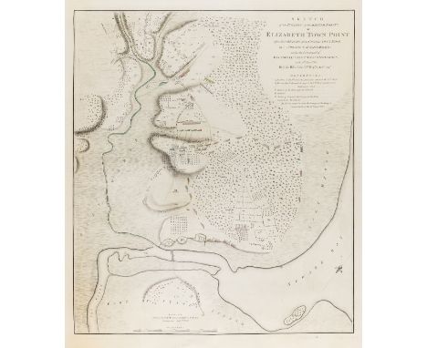
Lot 274
American Revolution.- British Invasion of New Jersey.- Faden (William) Sketch of the Position of the British Forces at Elizabeth Town Point after their Return from Connecticut Farm, in the Province of East Jersey, from Faden's 'Atlas of Battles of the American Revolution', engraving with some hand-colouring of regiments and river, on laid paper with large Strasbourg lily watermark, with countermark 'R G' and 'X I', platemark 625 x 530 mm (24 1/2 x 20 7/8 in), sheet 760 x 570 mm (30 x 22 1/2 in), central horizontal drying crease, full margins with some nicks to edges, careful repair in the lower margin of splits and small perforations, unframed, 1784Provenance:Ex-collection of the Late James Stevens Cox F.S.ALiterature:Nebenzahl, Atlas of the American Revolution, no. 33⁂ Fine 18th century impression of an engraving after a lost manuscript map made by the Revolutionary War cartographer, John Hills (fl. 1777-1816).

Lot 275
American Revolution.- Philadelphia.- Faden (William) A Plan of the City and Environs of Philadelphia, Survey'd by N. Scull and G. Heap, with vignette view of the Philadelphia State House in the lower centre, the second state of Faden's map, with soundings in the Delaware and Port Island present, engraving on laid paper with large Strasbourg lily watermark and countermark 'W F', platemark 640 x 480 mm (25 1/4 x 18 7/8 in), sheet 750 x 550 mm (29 1/2 x 21 5/7 in), faint horizontal drying crease, expert repairs to splitting and fine perforations to the tower of the State House and below within plate and margin, with corresponding faint browning, otherwise minor surface dirt, unframed, 1777Provenance:Ex-collection of the Late James Stevens Cox F.S.ALiterature:Nebenzahl, Atlas of the American Revolution no. 26
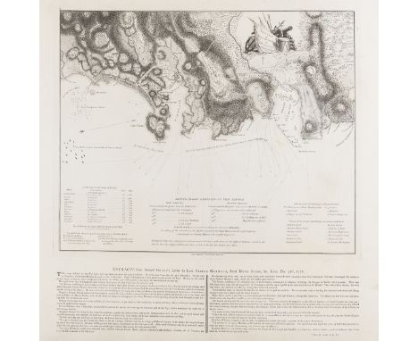
Lot 278
Caribbean.- Battle of St. Lucia.- Faden (William) Sketch of Part of the Island of Ste. Lucie, map by Lt. G.V. Hart, assistant engineer while in North America, showing the northwestern coast of Saint Lucia, specifically Grande Cul De Sac Bay to Castries, with details of British troops and fleets, and a letterpress extract from General Grant's Letter to Lord Germain printed below the map, engraving and letterpress on laid paper, an early state before full letters of GV Hart in lower right, platemark 405 x 495 mm (16 x 19 in), sheet 570 x 770 mm (22 1/2 x 30 1/4 in), full sheet with some careful repairs to splitting and perforations within the map and margins, minor surface dirt, unframed, 1781; together with two other duplicate impressions of the same map, one with significant damp-stains, the other with minor spotting and light abrasion, all unframed, 1781 (3)⁂ The Battle of the Cul de Sac was a naval battle fought between the British Royal Navy and the French Navy, off the island of St. Lucia during the American Revolutionary War on 15 December 1778. Following the battle the island eventually surrendered to the British.

Lot 281
Africa.- Barrow (John) An Account of Travels into the Interior of Southern Africa in the years 1797 and 1798, 2 vol., first edition, half-title in vol.1 (not called for in vol.2), large folding engraved map hand-coloured in outline and with routes in red, folding aquatint plate and 8 folding engraved maps, 2 hand-coloured, large map lightly offset and with hole to central fold, some foxing and soiling, vol.1 with browning to a few gatherings at beginning and end, tear to E1 in vol.2 but no loss, bookplate of Melville Portal of Laverstoke, contemporary sprinkled calf, spines ruled in gilt with red & green roan labels, rubbed and a little marked, spines worn at head, split to upper joint of vol.1, 4to, 1801-04.
![Levant.- [Sandys (George)] A Relation of a Journey begun An: Dom: 1610...Containing a description of the Turkish Empire, of A](https://cdn.globalauctionplatform.com/458dcef5-8ad2-4b82-ac33-ad1800cbd552/8f6e0bc5-4e77-4fc7-b8f8-ad180117cca8/468x382.jpg)
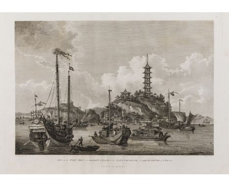
Lot 282
Levant.- [Sandys (George)] A Relation of a Journey begun An: Dom: 1610...Containing a description of the Turkish Empire, of Aegypt, of the Holy Land, of the Remote Parts of Italy and Islands adioyning, first edition, Charles I's large paper copy ruled in red, fine engraved architectural title by Francis Delaram, double-page engraved map mounted on stub, folding engraved panorama of Constantinople pasted in at p.32, 47 engraved illustrations and plans within text, 2 full-page, woodcut head-pieces and initials, variant issue without tail-piece at end of text, lacking final blank, with catchword "proclai" on C1r and "Turkish; built" as first words on D3v, with additional folding engraved map of Jerusalem loosely inserted (c.275 x 380mm, trimmed close to border, short tear to one edge), contemporary ink signature to title, some light soiling, a few stains, later ink note concerning provenance to front free endpaper, bookplate of Melville Portal of Laverstoke, nineteenth century brown morocco, by J.Mackenzie, preserving magnificent gilt-tooled calf covers from original binding of panel containing central gilt arms of Charles I with elaborate corner-pieces and small tools of Prince of Wales feathers to outer corners of panel, mounted within later border of thick gilt rule and inner decorative roll, spine gilt in compartments, turn-ins with multiple gilt rules, marbled endpapers, g.e., a little rubbed (mainly joints), original binding with holes from missing ties and rather scuffed on upper cover, [STC 21726; cf. Atabey 1087 (seventh edition) & Blackmer 1484 (second edition)], folio, Printed [by Richard Field] for W.Barrett, 1615.⁂ The dedication copy, presented by the author to Charles I when he was Prince of Wales.George Sandys (1578-1644), travelled to the Levant in 1610 and spent a year in Turkey, Palestine and Egypt. Blackmer describes this account of his travels as, "at the time the most elaborately illustrated English book on the Levant". Sandys later became treasurer of the Virginia Company and lived there for 10 years. This is the first book to record tobacco usage in Turkey, and includes an account of smoking in Constantinople.
Lot 288
China.- Staunton (Sir George) An Authentic Account of An Embassy from the King of Great Britain to the Emperor of China, 3 vol. including Atlas, first edition, presentation copy from the author with ink inscriptions to front endpapers of text volumes, text with 2 engraved portraits of the Emperor and the Earl of Macartney, engraved plate of Camellia and 26 engraved vignettes, portraits a little foxed, text with light foxing to a few gatherings but mostly clean and bright, vol.1 with slight staining to pp.398-399 and tear to upper margin of 3S3, contemporary half calf over marbled boards, a little rubbed, rebacked with spines titled and ruled in gilt, corners repaired, Atlas with 44 engraved maps, charts, plates and plans, 7 folding or double-page, the large folding map soiled and stained and lightly creased, most plates with tissue guards, some with light marginal spotting but generally clean, final plate with short marginal tear, modern half rexine, gilt-stamped roan label to upper cover, [Cordier, Sinica, 2381-83], 4to & folio, W.Bulmer & Co. for G.Nicol, 1797. ⁂ The official account of Lord Macartney's voyage and embassy to the Qianlong emperor in 1792-94, the failure of which led to the establishment of the British trading post at Hong Kong. It includes descriptions of the journey via Madeira, Tenerife, Rio de Janeiro, Java and Sumatra, Chinese customs (including foot-binding) and details of Chinese trade with Europe. The fine plates by Alexander show views of the Great Wall, temples, barges, a military post and imperial procession, and there is also a detailed map of Macao.The inscriptions read, "Jane Pigott the Gift of her old friend Sr George Staunton Bart. 1797" and "This valuable work of the highly esteemed friend of Sir Arthur and Lady Pigott is presented by her to her young friend John H.Lanyon in full confidence he will properly appreciate its value 20th August 1829".Sir Arthur Leary Piggott (1749-1819) was born in Barbados and became a lawyer and Whig MP, appointed Attorney-General in 1806.

Lot 291
Eastern Europe.- Lear (Edward) Journals of a Landscape Painter in Albania, lithographed map and 20 tinted lithographed plates, some foxing and browning, new endpapers, original blue blind-stamped cloth, gilt spine, slightly dulled, rebacked with the original spine laid down, [Abbey, Travel 45], large 8vo, 1851.
Lot 314
Polar.- Ross (Sir John) Narrative of a Second Voyage in Search of a North-West Passage, and of a Residence in the Arctic Regions during the years 1829...1833, vol. 1 only (lacks appendix), first edition, 5 maps and plans (including 1 large folding in pocket at rear), 16 engraved plates (some hand-coloured), 6 lithographs and 3 hand-coloured mezzotints, 1 map with neat tape repair, a few plates with margins trimmed and laid down or with marginal repair, some occasional light foxing but a very clean copy generally, modern half calf, spine gilt, 4to, [Abbey Travel 636], 1835.

Lot 315
Russia.- Baedeker (Karl) Russia: with Teheran, Port Arthur, and Peking, first edition, maps and plans, many folding, frontispiece map with some tearing to inner margin, neat early ink ownership inscription to endpaper, original cloth, light bumping to corners, else fine, dust-jacket, browning and ink marking to spine, spine ends and corners chipped, lower panel with very short closed tear to head and foot, light creasing to head and foot, but an excellent example generally, 8vo, 1914.
Lot 346
World.- Purchas (Samuel) Purchas his Pilgrimes. In Five Books..., 5 vol. including vol.5: Purchas His Pilgrimage, first edition of vol.1-4, vol.5 fourth edition, second issue with dedication to King Charles, Narcissus Luttrell's copy with his ink monogram stamp to titles and date "1697" in his hand below, lacking additional engraved title (as often), with 7 folding and/or double-page engraved maps of the Mogul Empire, China (duplicated in vol.5), Greenland (Spitsbergen), North America, New England and Virginia, 81 half-page engraved maps after Hondius (58 in vol.1-4 and 23 in vol.5, the latter duplications of maps in vol.1-4), woodcut initials, head- and tail-pieces and a few other engraved or woodcut illustrations including Aztec pictograms from the Codex Mendoza in vol.3, vol.1 with Hondius's 'Map of the Christian World' appearing twice at pp. 65 and 115 i.e. lacking 'Map of the Whole World', and with G3-4 uncancelled as usual, also 4M4-5 uncancelled and first state of 4M2 with headline "Hollanders lying devices, to disgrace the English", map of Virginia trimmed at foot just within border, duplicate map of China with margins repaired and restored, vol. 1 3L4, 3Y5, vol. 4 5M5 and vol. 5 A5 with paper flaw or small hole with loss to a few letters of text, vol. 1 4N3-4 with some soiling, creasing and repair to text, vol. 5 last f. laid down, vol. 3 with some worming to head of fore-margin, very occasional small rust-holes to text, the odd paper-flaw to margin, occasional repairs or restorations to margins, a few just touching text, occasional scattered foxing, some light offsetting, but a very good, clean copy generally, a few small ink corrections, seemingly in Luttrell's hand, bookplates to endpapers and pastedowns, bookseller's receipt from 1964 loosely inserted, 18th century speckled calf, rebacked, spines gilt in compartments with morocco labels, some light cracking to head or foot of joints, some bumping to corners, [Hill 1402-3; Sabin 66682 & 66686; STC 20508-9], folio, by William Stansby for Henrie Fetherstone, 1625-26.⁂ An excellent set of this important collection of voyages, a continuation of Hakluyt's Principal Navigations, with fine impressions of the maps and a distinguished provenance. Likely to have been one of the most cherished books in Luttrell's library. The map of the Mogul Empire by William Baffin is the earliest English map of the Mogul territories; the map of China is based on a Chinese original and one of the earliest such to be published in Europe; the map of Greenland (actually Spitsbergen) incorporates scenes of whaling and bear-hunting; the map of North America, by Elstracke after Henry Biggs, is the first to show California as an island; the map of New England was first published in 1624; the map of Virginia by William Hole after Capt. John Smith is one of the most important early maps of America and includes a large Indian figure and a vignette depicting the interior of Powhatan's hut.Provenance: Narcissus Luttrell (1657-1732), parliamentary historian and diarist, bibliographer of works concerning the Popish plot, and compiler of a large library (ink stamps); Chapman-Purchas; C. H. Wilkinson (bookplates).

Lot 348
London.- Stow (John) A Survey of the Cities of London and Westminster, and the Borough of Southwark, edited by John Strype, 2 vol., sixth edition, large folding map of London mounted on stub, titles in red and black with date corrected by hand to "1598" on title of vol.1, 130 engraved plates and plans only (of 131, lacking plate of Merchant-Taylors School at p.524), many double-page and/or folding, woodcut coats-of-arms and a few illustrations or diagrams, plate of St.Botolph without Aldgate opposite p.369 with imprint shaved, last few leaves and plates of vol.1 lightly damp-stained at outer margin (some repaired), one or two other minor marginal repairs, bookplate of Melville Portal of Laverstoke, later panelled calf, gilt, by Rivière & Son, spine gilt in compartments with six raised bands, a little rubbed and scuffed, upper cover of vol.1 detached, folio, for W.Innys and J.Richardson [& others], 1754-55. ⁂ A lovely clean copy of the best edition, comprising the text from Strype's fifth edition of 1720 with the addition of the magnificent plates of London squares.
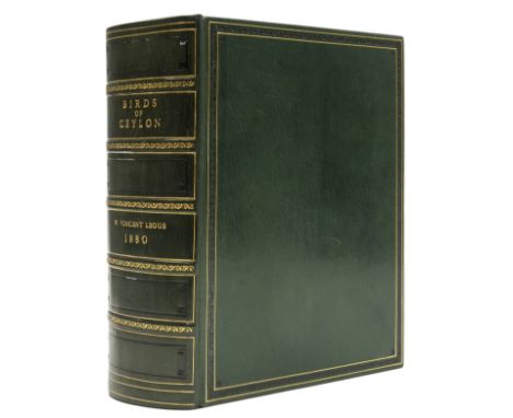
Lot 365
Legge (Capt. W. Vincent) A History of the Birds of Ceylon, first edition, frontispiece, hand-coloured engraved map (imprint slightly trimmed), 34 fine hand-coloured lithograph plates after J.G. Keulemans (1 of eggs), wood-engraved illustrations, folding leaf Appendix III loosely inserted at end, modern green morocco, decorated in gilt and blind, [Anker 284; Fine Bird Books p.89; Nissen IVB 539; Wood p.439], 4to, Published by the Author, 1880.⁂ A superb, clean copy of this "comprehensive account of the birds of the area" (Anker).
Lot 50
Playing cards.- Della Bella (Stefano) Jeux Historiques des Rois de France, Reines renommees, Geographie et Metamorphose, complete series of 4 sets of educational playing cards in 1 vol., 12pp. preliminaries comprising printed title, playing instructions and privilege (dated 1644), 4 complete sets of engraved playing cards comprising title and 52 plates, except for Rois de France which has title and 39 plates (as issued), a few plates loose and a couple misbound, but generally clean and with full margins, minor light foxing and finger-soiling, title of Queens with slight water-stain to corner, contemporary calf, worn, upper joint repaired, 12mo, Paris, Chez Nicolas le Clerc et Florent le Comte, 1698.⁂ Very rare to find complete and in such good condition. The complete series of four educational playing card sets commissioned by Cardinal Mazarin for the instruction of Louis XIV, who ascended to the throne in 1643 under the regency of his mother. They were prepared by Jean Desmarests, a member of the French Academy, and first printed in 1644 under the Paris imprint of Henri Le Gras and Florentin Lambert. After Lambert's death the plates were sold to Florent le Comte who added suit-marks of spades, clubs, hearts, and diamonds, and reprinted them in book form in 1698. It is curious that in this copy the imprint "F. Le Conte" [sic] occurs on the engraved title leaf for the Mythology series but the three other series of playing cards still retain the original "Henri le Gras" imprint [from 1644). The Kings begin with Pharamond and Clodion and end with young Louis (King of Hearts); in some instances, as many as five kings of France are featured on one card, each numbered and listing the length of his reign. The Queens begin with Martesie, queen of the Amazons, and end with Anne of Austria, the mother of King Louis - a single adjective is given at the upper right corner describing each one: pious, cruel, unfortunate, saintly, wise, brave, etc. Geography has a title card showing a twin-hemisphere map and the cards themselves comprise emblems of individual countries (divided into four sections, each a different continent): the Americas are represented by Peru, Mexico, Canada [Nouvelle France], Virginia, Florida, Yucatan, Nicaragua, Quivira [in Wichita, Kansas], Chile, Brazil, Popaian [Columbia], and Castile d'or [i.e. Panama]. Mythology ("jeu des fables") represent the Greek myths, including the stories of the nine Muses, Mercury, Neptune, Pygmalion, Hercules, Jason, Apollo, Narcissus, and Medusa."They are all extremely interesting and of much rarity, and from an artistic standpoint are of value as the work of the famous Florentine engraver Stefano della Bella" (Hargrave, History of Playing Cards, pp. 58-59).


Lot 6106
Railway Clearing House - Official Railway Map of the East of England 1912, engraved folding coloured railway map dissected and backed onto linen, showing area from Nottingham/Oxford in West over to Norfolk/Suffolk/Essex and incorporating London. various lines coloured, some contemporary ink and pencil notes relating to station etc. Approx size 75m x 118cm folding into original black leather gilt binding, later rebacked

Lot 6107
'Bradshaw's Railway Companion', London 1843, folding London map, double page city maps of Birmingham, Bristol, Manchester & Liverpool. 18 pages of maps with hand colouring, folding map of railways in England & Wales, original cloth, original green and gilt label to upper board, from the collection of John Phillimore (died 1940), motorist correspondent for the London Times & authority on the history of transportation


Lot 296
Unusual route map of the Emin Pasha Relief Expedition (1886-9), 77 x 69cm, plus smaller map of Emin Pasha's Province, 27 x 28.5cm. Both undated but of the period. Emin Pasha was General Gordon's Governor of Equatoria, threatened by Mahdist forces in Sudan that took General Gordon's life at Khartoum in early 1885.


Lot 315
WW2 Period British Propaganda Poster “NAZI WAR AIMS”, small printed poster detailing the dates in which Nazi Germany wanted to colonise Europe, including the United Kingdom by 1948. Poster slogan “NAZI WAR AIMS – Revealed by Secret Nazi Map – circulated 1937 – GRAB! GRAB!! GRAB !!! THAT’S the Nazi Policy”. No printers details. Measures 50 x 38cms. Some fold marks and light foxing. Small pin holes to corners.
-
109198 item(s)/page