We found 109198 price guide item(s) matching your search
There are 109198 lots that match your search criteria. Subscribe now to get instant access to the full price guide service.
Click here to subscribe- List
- Grid
-
109198 item(s)/page


Lot 351
An early Victorian drawing or sketchbook, with landscape and views of buildings on 21 leaves, including one Rhineland scene, oblong 8vo;London As It Is Today...., the Great Exhibition, 1851, 8vo, with folding map of London; WILSON (J), The Lands of the Bible, 2 vols, 1847, folding maps, some foxing; HOGARTH (W) The Works of...Moralized, by John Trusler, circa 1800, worn calf and 4 others (8)


Lot 356
BURTON (Richard F.), The Book of the Thousand Nights and a Night, no. 8 of 1000 sets, c. 1890, printed for private circulation, frontispieces, 8vo; with Supplement volumes, original cloth (faded) (together 17 vols); LIVINGSTONE (D.), Missionary Travels and Researches in South Africa, 1861, 8vo, illustrations, folding map, calf; MUDIE (R.), The Feathered Tribes of the British Islands, 2 vols, 1835, coloured plates, cloth (worn); and various others including Natural History etc. (40)

Lot 113
COLLINS (Samuel) The Present State of Russia, London: John Winter for Dorman Newman, 1671, small 8vo, six plates, one torn with loss, title and frontispiece soiled and worn, generally age worn, modern half calf; [COLBACH (John)] An Account of the Court of Portugal, London 1700, 8vo, rebacked calf; BOSWELL (J) An Account of Corsica, .. and Memoirs of Pascal Paoli, London 1769, 8vo, frontispiece, folding map with repaired tear, calf (front board near detached) (3)

Lot 265
Some Account of the Conduct of the Religious Society of Friends towards the Indian Tribes..., London: Edward 1844, 8vo, coloured map frontispiece, title stained, partly unopened, recent good half calf. Note: Other copies of this work include an additional folding map not present in this copy. WHITCHURCH (Samuel) David Dreadnought, or Nautical Tales and Adventures in Verse, Bath 1813, 12mo, some foxing and toning, later calf backed marbled boards (2)


Lot 472
VEITCH (James H.) A Traveller's Notes, or Notes of a Tour through India, Malaysia, Japan, Corea, The Australian Colonies and New Zealand during the Years 1891-1893, London: for private circulation 1896, 4to, folding map frontispiece, slight foxing, nine photogravure plates of the Far East, tissue guards, original worn cloth gilt

Lot 379
Literature, leather bound. Various works including 18th century, odd volumes and others, in varying condition, including: A Topographical and Historical Account of.. Norwich, 1819, 8vo, folding map, uncut, age staining, rebacked boards; A General History of the County of Norfolk, 2 vols., 1829, thick 8vo, folding map, cloth; LEADBETTER (C) The Royal Gauger, 1750, thick 8vo, folding diagrams, sign of use, modern calf; also Classic works by Greek and Roman authors (Glasgow Academic imprint), etc. (sold not subject to return).

Lot 109
The PRECEPTOR in two vols., London 1769, 5th edition, 8vo, six folding maps with outline colour (including world map), 28 folding plates (some with tears and creases), extra-illustrated with four natural history plates in colour and two portraits at end of vol. I, recased with good calf reback


Lot 70
Thomas Kitchin (1718-1784) Map of the United States in North America, with the British, French and Spanish Dominions adjoining, according to the Treaty of 1783, folding engraved map, uncoloured, published by T. Cadell 1st May 1783, four months before the signing of the Treaty of Paris, the earliest English map to officially acknowledge the sovereignty of the United States by its proper name, 44.5 x 53 cm


Lot 95
Bible. An Illustration of the Holy Scriptures, by Notes and Explications of the Old and New Testament, sixth edition, 1759, folio, two vols. only, (lacking the New Testament), engraved frontispiece, map, numerous plates including folding, typical family names to fly leaf, worn calf, spines damaged. Sold not subject to return. [Ref. Herbert 1126] (2)
![WILLIAMS (Lieut.-Col.) The Life and Times of the Late Duke of Wellington, 4 vols, [c. 1855], 4to, with portrait, maps and pla](https://cdn.globalauctionplatform.com/9c386304-0dc5-4996-a2cd-a5a600a820d5/e8b5560d-f36d-40e0-8c14-fce49d78be1b/468x382.jpg)
Lot 261
WILLIAMS (Lieut.-Col.) The Life and Times of the Late Duke of Wellington, 4 vols, [c. 1855], 4to, with portrait, maps and plan of Brussels, lacking map of Russia and two plates (Death of Nelson and Surrender of the sons of Tippoo Sultan), with additional map of Denmark and Nile plate, slight foxing, half calf


Lot 464
WAKEFIELD (Priscilla) The Traveller in Asia: or, a Visit to the... East Indies and China, 1817, 12mo, folding engraved map with small tears, title a little stained, leaf of advertisements at end, rebacked; WEEDON (Thornhill) Queensland Past and Present, 1897, signed by the author, faded cloth spine; HARCUS (W) South Australia, 1876, 8vo, maps in pocket at end, original cloth gilt; WALLACE (A R) The Malay Archipelago, sixth edition 1877, illustrated, cloth; together with three others - horses (7) Please note there is no CRAWFORD in this lot

Lot 448
OLIVER (G) Monasticon Dioecesis Exoniensis, Exeter, 1846, folio, rebacked; GILBERT (C S), Historical Survey of Cornwall, 2 vols, 1817-20, 25 armorial plates only, lacking other plates and map, binding detached and damaged; together with others later on Cornwall and Devon, general literature and history etc., to include TILLOTSON (Dr. J), The Works of, 4th, 1728, folio, repaired binding; some leather bound, all in varying condition


Lot 471
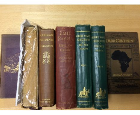
Africa - travel. MOUNTENEY-JEPHSON (A.J.) Emin Pasha, 1890, folding map and plates, worn cloth; BAKER (S.W.) The Albert N'Yanza Great Basin of the Nile, two vols., 1866, 8vo, plates, two maps only (one folding) though called for in both volumes, original cloth; WALLER (H) The last Journals of David Livingstone, 1874, two vols., folding map, vol. II damaged; THRUSTON (Major A.B.) African Incidents, 1900; one other (7)

Lot 184
A Collection of 19th century volumes, presented to William Oswald Massingberd, on leaving Eton in 1867. NIEBUHR (B G) The History of Rome, 3 vols, 1855, folding map, polished calf by Bickers; MACKINTOSH (Sir J.) History of England in 2 vols, 1853, calf; together with various other literature and history, in leather bindings, condition varies; MILTON (J), Poetical Works, in 2 vols, 1866 (Bickers) etc.

Lot 57
J. Van Keulen Pas-Caart van der Weder zytche Zee-Kuften soo van Italia als Dalmatia en Grieeken, hand coloured engraved map, c.1695 (or later), some spotting and chipping, mounted, 52 x 60cm; and - J.Lodge, The Kingdoms of Portugal and Algarve, hand coloured engraving, published Laurie and Whittle 1808, 59 x 42cm (2)

Lot 473
India. Collection of 20th century works: FORTESCUE (J) The Royal Visit to India, 1911-12, full crushed morocco by Hatchards; a folding dissected map of India c.1900 by Stanford; AFLALO (F.G.) The Sportsman's Book for India 1904, folding map, slight spotting; O'DWYER (Sir Michael) India as I knew it, 1929, stained cover LOVETT (Major A. C.) The Armies of India, 1911, plates; MACKENZIE (D.A.) India Myth and Legend, 1913; PIKE (H.W.) The Wise Beasts of Hindustan, colour plates; others

Lot 256
KENT The Poll for Knights of the Shire..., 1791, 8vo, uncut, rebacked boards; FURLEY, A History of the Weald of Kent, 2 vols in 3, 1871, 8vo, folding maps, cloth (rubbed); CAMDEN (W) Britannia - Kent section, 1695, with folding uncoloured map, boards; LARKING (Rev. L.) The Domesday Book of Kent, 1869, folio, two copies, one in damaged binding; and others, later, of Kent interest


-
109198 item(s)/page