We found 109182 price guide item(s) matching your search
There are 109182 lots that match your search criteria. Subscribe now to get instant access to the full price guide service.
Click here to subscribe- List
- Grid
-
109182 item(s)/page


Lot 221
A collection of Taxco and Mexican Modernist silver jewellery,to include a silver and abalone panel bracelet, with engraved panels alternating to bead decorated panels, all set with abalone, to concealed clasp, engraved 'Hecho En Mexico D.F.', unidentified mark MAP, marked sterling 925 Taxco, and a pair of silver cufflinks, by Sigi Tasco, together with a tie bar clip, of the same design, marked 'Sterling Hecho En Mexico no.46', 79.45gCondition ReportTarnish to the bracelet.Scratches to the abalone sections.Tarnish to the cufflinks and tie bar.Bracelet 185mm in length (excluding the clasp tongue), panels about 28mm to 31mm wide.

Lot 269
A GERMAN BRONZER SAAR, commemorative pin badge, this badge is maker marked Deschler on the reverse and is complete with its original pin, the front features a map of the SAAR region superimposed to the Swastika, this badge was previously authenticated by Craig Gottlieb in California, Customers must satisfy themselves prior to sale in regards to conditions and authenticity, viewing is advised, condition reports are available on request
Lot 444
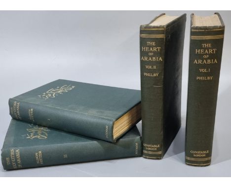
Philby, H.St.J.B. 'The Heart of Arabia', first editions, in two volumes, Volume I & II, illustrated, published by Constable & Company Ltd, 1922, cloth bound. Together with Rutter, Eldon, 'The Holy Cities of Arabia', Volume I & II, first editions, published by G.P Putnam's Son Ltd, London & New York, first edition 1928. (4) (B.P. 21% + VAT) All four have owners name signed in pen to inside of front cover. Holy cities of Arabia, both volumes - bindings are slightly grubby, very minor marks/foxing to front/end pages but generally good internally. Vol 1 has 'Plan of Mekka' map and illustration to front, Vol II has two maps and illustration to front. The Heart of Arabia - both volumes bindings a bit worn/some scratches and marks. Edges of pages are worn, generally ok internally. All illustrations and maps are present. One of the two fold out maps in Volume II has a minor tear to the corner.


Lot 355
Janet Jackson / Velvet Rope Tour Merchandise plus, a number of Items from the Velvet Rope tour 1998 comprising two different T shirts (both Large), Baseball Cap, Programme, Wembley Arena Ticket with map, seating plan and train ticket plus poster and photo application forms - all in very good condition and sold with a 10" by 8" colour photo with a signature and a 1990 Tour Programme


Lot 404
Emanuel Bowen, 18th century hand coloured engraved map "An Improved Map of the Counties of Cumberland and Westmoreland divided into their respective Wards", 50cm x 40cm, in Hogarth frame. Some browning, damp staining and worm damage. Also a framed description of Cumberland with hand coloured vignette, in Hogarth frame, 33cm x 20cm. (2).


Lot 403
Emanuel Bowen & Thomas Kitchin, 18th century hand coloured engraved map "A New Map of the Counties Cumberland and Westmoreland divided into their respective Wards", dated 1760, printed for T. Bowles, St. Paul's Churchyard, Robert Sayer, Fleet Street and John Bowles & Son in Cornhill, 21cm x 56cm, in Hogarth frame. Some damp staining and browning.


Lot 256
Steven Hubbard (born 1954)/Eastcombe in Winter/with a marquetry plaque map of Eastcombe below/monogrammed lower right/oil on canvas, 57.5cm x 39cm CONDITION REPORT: ARR Artist's Resale Right may apply to the sale of this lot if the hammer price is the equivalent of 1000 Euros or more, incurring an additional fee. For further information please ask Chorley's or visit www.dacs.org.ukCondition information is not usually provided in the description of the lot but is available upon request; the absence of a condition report does not imply that a lot is without imperfection


![Railwayana - a Great Eastern Railway [GER] diagramatic map of system, 25/12/19 with compliments from FV Russell, superintende](https://cdn.globalauctionplatform.com/f52ce714-ef96-40d5-8812-af7400a72014/771496c0-ef74-4615-a237-afcf01347302/468x382.jpg)


Lot 931
Books - Dickens, Charles, Oliver Twist, Chapman and Hall, 1865; a map fold out cloth bound, of London 1903, G Phillip & Son. Ltd, 32 Fleet Street; Potter, TR, Charnwood Forest, The History and Antiquities, 1842; Allen's Illustrated Hand Book, Charnwood Forest An Appendix, signed in pencil to front cover interior, 1857; a King James Bible, c.1818 (5)
Lot 145
A bronze WWI death penny,named to Frank William Lille, in a wood frame,total 18cm diametertogether a jambiya,with a leather scabbard,34cm longa group of military and other books and ephemera,to include The Story of The Royal Army Service 1939-1945, The Army List for June 1857, The Racing Calendar 1832 and 1844, and a map depicting the Gulf of Aden and Southern Part of the Red Sea, dated 1970,and a collection of shell fragmentsShipping disclaimer: Buyers must be aware of their country’s shipping and import policies regarding guns, knives, swords, and other offensive weapons prior to purchase. They are required to ensure that the lot can be delivered by a specialist shipper, whether in the UK, Europe or internationally. No compensation will be given to buyers who fail to organise shipping arrangements for goods and weapons due to the prohibitions, restrictions or import regulations of their country.Condition ReportThe Jambiya scabbard is heavily worn. Wear and losses to the books. The death penny appears to be in a good condition, with some marks to the frame.
Lot 1672
Group of leather bound antiquarian agricultural books including Jethro Tull - The Horse-Hoing Husbandry, 2nd edition, A. Millar, 1743, together with Marshall - Experiments and Observations concerning Agriculture and the Weather, engraved map, first edition, 1779, also Course of Experimental Agriculture, three of the four-volume set, first Irish edition, Dublin 1771, also The Complete English Farmer….by a Practical farmer and friend of the Late Jethro Tull, 1771, George Winter - Compendiuous System of Husbandry 1787, various other leather and board bound volumes on similar theme. (3 boxes)


Lot 490
A BOX AND LOOSE SCALES, MAP, CAMERAS AND SUNDRY ITEMS, to include a set of EKS bathroom scales, a framed Maps International Classic Political map of the United Kingdom, framed size 85cm x 61cm, a Sony Digital Mavica MVC-FD81, a leather cased pair of Bino Prism No 5 binoculars made by Ross, London, crown green bowls, etc (1 box + loose) (sd, untested)

Lot 521
SIX DECORATIVE PRINTS AND WALL PLAQUES, comprising a framed print depicting a 19th Century maritime scene, approximate size including frame 40cm x 45cm, three Marcus Designs reconstituted wall plaques depicting knights, a reproduction print of Lichfield Cathedral and a copper Robert Morden map of Shropshire (6)


Lot 35
Thomas Gardner (fl. 1719), an early 18th century hand coloured map entitled; 'The Road from Exeter to Truro in the Com. of Cornwall', from 'A Pocket Guide for the English Traveller', pg 69, 18.5cm x 28cm, framed and glazedCONDITION REPORTS & PAYMENT DETAILSIMPORTANT* Descriptions do not include condition reports. Please contact us to if you require further information or images.* Please consider shipping costs before bidding as this may affect your decision to bid* Please familiarise yourself with our payment methods. Our preferred method of payment is by bank transfer. We do not take cash or card payments.

Lot 29
John Speed, 'Sussex Described and divided into Rapes, with the situation of Chichester the cheife citie thereof and the armes of such nobles as have bene dignified with the title of Earles since the conquest and other accidents therein observed' after John Norden, sold by Thomas Baysitt and Richard Chiswell, engraved hand coloured map with inset city plan of Chichester, 39cm x 51.5cm, framed and double-glazed to show the text to the reverse.CONDITION REPORTS & PAYMENT DETAILSIMPORTANT* Descriptions do not include condition reports. Please contact us to if you require further information or images.* Please consider shipping costs before bidding as this may affect your decision to bid* Please familiarise yourself with our payment methods. Our preferred method of payment is by bank transfer. We do not take cash or card payments.

Lot 34
Thomas Bowen, two 18th century maps entitled 'A new and accurate map of Africa drawn from the best authorities' and 'An accurate map of South America from the best modern maps and charts', numbered 67 and 69, 36cm x 43cm and 34.5cm x 45.5cm, both framed and glazedCONDITION REPORTS & PAYMENT DETAILSIMPORTANT* Descriptions do not include condition reports. Please contact us to if you require further information or images.* Please consider shipping costs before bidding as this may affect your decision to bid* Please familiarise yourself with our payment methods. Our preferred method of payment os by bank transfer. We do not take cash or card payments.

Lot 36
Gerard Mecator and Henricus Hondius, hand coloured map entitled 'Angliae VI Tabula', from the early 17th century pocket version of 'Atlas Minor', pg 91, 15.5cm x 19cm, framed and glazedCONDITION REPORTS & PAYMENT DETAILSIMPORTANT* Descriptions do not include condition reports. Please contact us to if you require further information or images.* Please consider shipping costs before bidding as this may affect your decision to bid* Please familiarise yourself with our payment methods. Our preferred method of payment is by bank transfer. We do not take cash or card payments.
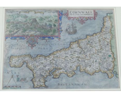
Lot 28
William Kip, 'Cornwall Olim pars Danmoniorum', after Christopher Saxton, published in 1607 (first edition) for Camden's Britannia, hand-coloured engraved map, with inset view of Launceston, 30cm x 39.5cm, framed and glazedCONDITION REPORTS & PAYMENT DETAILSIMPORTANT* Descriptions do not include condition reports. Please contact us to if you require further information or images.* Please consider shipping costs before bidding as this may affect your decision to bid* Please familiarise yourself with our payment methods. Our preferred method of payment is by bank transfer. We do not take cash or card payments.

Lot 31
John Speed, 'Britain as it was divided in the tyme of the Englishe Saxons especially during their Heptarchy', sold by Thomas Bassett and Richard Chiswell, hand-coloured engraved map, 38.5cm x 51.5cm, framed and double-glazed to show the text to the reverseCONDITION REPORTS & PAYMENT DETAILSIMPORTANT* Descriptions do not include condition reports. Please contact us to if you require further information or images.* Please consider shipping costs before bidding as this may affect your decision to bid* Please familiarise yourself with our payment methods. Our preferred method of payment is by bank transfer. We do not take cash or card payments.

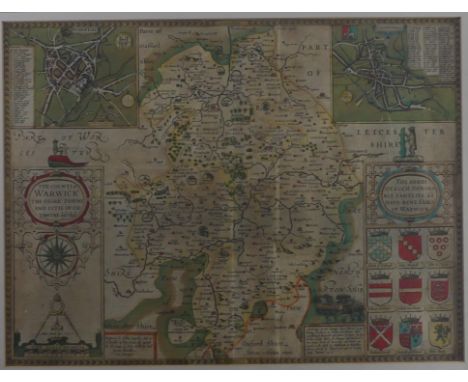
Lot 166
Speed (John), The Counti of Warwick the Shire Towne and Citie Coventre described, John Sudbury and George Humble, circa 1627, hand-coloured engraved map, inset town plans of Warwick and Coventry, large strapwork cartouche and mileage scale, 38cm x 51cm, Latin text on verso, overmounted and framed and double-glazed.


Lot 108
A group of assorted framed maps, including hand-coloured strip map of ‘The Road from Welshpool’, after John Ogilby, originally published circa 1695, probably 18th century edition, 36cm x 43cm; also ‘The Road from Prestain’; ‘The Road from Chester’ and ‘The Road from Kings Lyn’, all after John Ogilby; together with maps of Buckinghamshire, Leicestershire and Sussex (7)

-
109182 item(s)/page