We found 109182 price guide item(s) matching your search
There are 109182 lots that match your search criteria. Subscribe now to get instant access to the full price guide service.
Click here to subscribe- List
- Grid
-
109182 item(s)/page


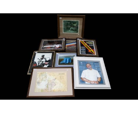
Lot 699
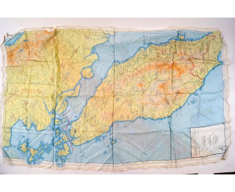
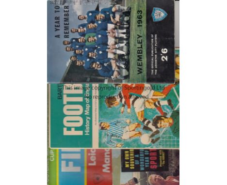
MISCELLANY Small collection of football items comprising Bartholomew Football History Map of England and Wales (probably 1960s), Northampton Town Players Promotion booklet 1964-65, Leicester City Cup Final booklet 63, Celtic Year of Triumph booklet (Weekly News) 1967, Booklet produced in Hungary showing all the goals from Hungary 7 England 1 in 1954 in Budapest, (tape on spine otherwise good), 1969 Cup Final programme plus Daily Mirror 1969 Cup Final Souvenir Booklet, plus Blackpool rosette (probably 60s) and Hornet Sport booklet giveaway 1966(tape on spine). Fair-generally good


Lot 288
DOUBLE EAGLE II: Signed and inscribed 8 x 10 photograph by all three crew members of Double Eagle II individually, comprising Ben Abruzzo, Maxie Anderson and Larry Newman, being the pilots of the first balloon to cross the Atlantic Ocean, 1978. The composite image depicts the balloon in flight, a map charting the route of the historic flight and an image of the three crew members in three quarter length poses together. Signed by each in black inks to the base of the image, Abruzzo adding an inscription in his hand and Anderson adding DEII in his hand beneath his signature. The image also features facsimile signatures of each of the crew. Autographs of Abruzzo are scarce following his untimely death in an airplane crash. VG
Lot 391
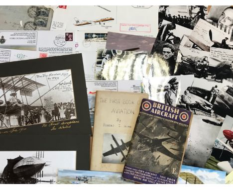
AVIATION: Selection of various air force and space flight ephemera and collectables, including printed R.A.F. flight documentation, a Fleet Air Arm Meteorologist Sleeve Badge, commemorative postal covers celebrating various aviation anniversaries, postcards and photographs depicting aircraft, pilots and astronauts, reproduction photographs of German Luftwaffe personnel of World War II, printed aviation newsletters and programmes, a selection of metal and plastic toy aircraft (some damaged), part of the original main spar from the Avro Lancaster PA 474 (limited edition of 1000 pieces), Air Training Corps Gazette, February 1943, The Aeroplane Spotter, January 1945, Flight, October & November 1909, The Aeroplane, November 1911, a facsimile hardback edition of the Flying Log Book of Group Captain T.F. Dalton-Morgan, a boxed video history of the R.A.F. presented by Richard Todd, an unconstructed Revell 1:72 model of the Avro Lancaster “Dam Buster”, an unidentified Aeroplane Log Book, a souvenir ticket made of metal from one of the crashed gliders which carried the British 1st Airborne Division into battle at Arnhem, a facsimile hardback edition of the Flying Log Book of Wing Commander Robert Stanford Tuck (limited edition 445/2500), a set of Churchman cigarette cards, The R.A.F. at Work, a map of Great Britain displaying aeronautical information, September 1948 etc. Generally G to VG, 162
Lot 519
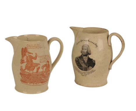
CREAMWARE JUG transfer printed in red with "The Governor of Europe stopped in his career", the reverse inscribed "Success to the Volunteers" within a border of hops incorporating a barrel, 13.5cm high, and another creamware jug dedicated to "Admiral Lord Nelson and The Battle of Trafalgar" with a vignette portrait on one side and a map on the other, 14.5cm high (2)Provenance: The Estate of the late Sir Edward du Cann KBE (1924-2017)

Lot 586
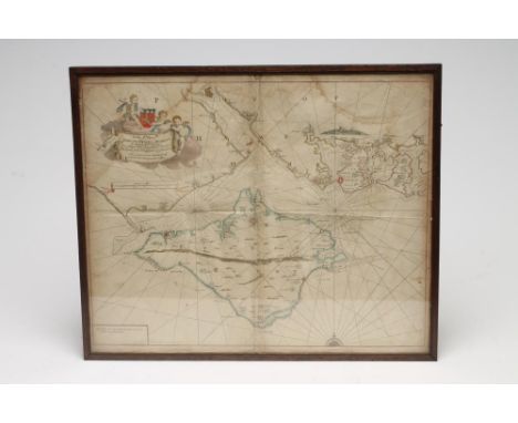
JOHN SPEED HAND COLOURED MAP OF THE COUNTY OF PALATINE OF CHESTER, 17TH CENTURY, showing the city of Chester, towns and villages, performed by John Speed assisted by William Smyth, sold by Thomas Bassett in Fleet Street and Richard Chiswell in St Paul's Churchyard, verso printed with a description of The County Palatine of Chester, 56cm wide, 45cm highProvenance: The Estate of the late Sir Edward du Cann KBE (1924-2017)


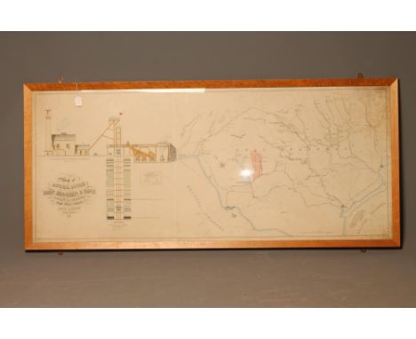
Lot 1390A
Railiway Interest An Original Map of LNER (GE section) Suburaban area 1924, cut and pasted 1958 to preserve it. Together with a GER Original Working Timetable 1st April to 30th June 1913 In a worn condition but legible. Rescued on closure of 'Whitegates; Shenfiled Wartime Central Control and Southern area 1960


Lot 1236
A pair of vintage Bristol related framed prints to include the S.S. Great Britain by J. Walter in 1845 depicting the ship being warped out of Avon Dock, printed in England by Allen Davis & Co. and a print of James Millerd's view of Bristol from 1673 republished by the Bristol Evening post 1973 in commemoration of Bristol's 600th year as a city and county.The map features he Royal Fort, the river Avon and annotated areas of north and south Bristol.


Lot 104
Richard Blome - Britannica or a Geographical Description of the Kingdoms of England, Scotland and Ireland with the Isle and Territories thereto belonging and for the better perfecting of the sail work there is an Alphabetical Table ...., printed by Tho. Roycroft for the undertaker Richard Blome 1673, red and black printed title page, dedicated page to Charles II, preface and five pages of tables, twenty four pages of heraldic shields, folding map of the British Isles, text interspersed with many folding maps of the countries, Wales, Scotland and Ireland and a plan of London, bound in marble boards with a brown leather spine

Lot 109
George Catlin - North American Indians, letter and notes on the manners, customs and conditions of, two volumes, pub London at the Egyptian Hall 1841 1st ed, illus. frontispiece and throughout the volumes, with folding map, 'Frederick' instead of 'Zacharias' on page 104 line 26, page 105/106 bound between 114 and 116, ex Wakefield library, marble boards with titled leather spines and corners


Lot 308
THE HOLY BIBLE CONTAINING THE OLD TESTAMENT, AND THE NEW, 1620, Bonham Norton and John Bill, bound in 19th century full calf, rubbed but sound, marbled endpapers, inscribed 'Reginald Ramsden from his father'. General title page present with 18th century family genealogy to verso. New Testament dated 1621, followed by Genealogies with map; Two Right Profitable Concordances, 1622 (Est. plus 17.5% premium)
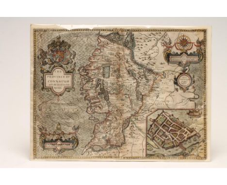

Lot 315
OWEN AND BOWEN (18th Century), "The Road from Bristol to Exeter", hand coloured map, from "Britannia Depicta" 1720-1764, 7 1/4" x 4 3/4", together with another "Exonia Excaster", H. Rutgerus 1661, "Herefordshire" by P. Van der Keere, "Isle d'Albion" by A. Mollet 1683 and a plan of Leeds, 19th century, all framed (5) (Est. plus 21% premium inc. VAT)


Lot 317
NORTH AMERICAN INTEREST, Rigobert Bonne, "Carte de La Louisiane", c.1785, hand coloured map, 13" x 8 3/4", together with Bellin's "Hudson Bay" 1757, 8 3/4" x 12", Kitchin's "Map of French Settlements in North America", 1747 and three others, "Rhode Island" c.1780, "A Sketch of Operations Before Charlestown", 1780, and "...Operations of the American and British Armies", 1776-1777, all framed (6) (Est. plus 21% premium inc. VAT)

Lot 319
EMANUEL BOWEN, an Accurate Map of the West Riding of York Shire divided into Wapantakes drawn from Surveys and illustrated with Historical Extracts Relative to its Natural Products, Trade and Manufactories ... published by Robert Sayer, John Bennett, John Bowles & Carington Bowels 1777, engraved map with contemporary outline colouring, originally published in "The Royal English Atlas" (Est. plus 21% premium inc. VAT)


Lot 354
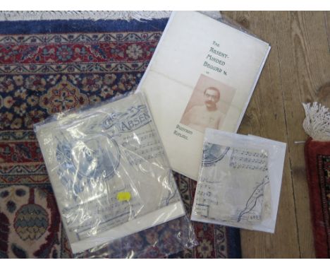
Arthur S. Sullivan: Two silk handkerchiefs printed with The Absent Minded Beggar with the words by Rudyard Kipling, a map of Southern Africa and a portrait of Lord Roberts another in cotton, and two brochures of The Absent Minded Beggar published by the Daily Mail Part of the late Peter Joslin collection of Gilbert & Sullivan and Theatre memorabilia

Lot 379
Books: A Philips Map of London for Visitors, 1877, hardbacked (as found); The Panorana of London by T. Allen, 1830 (rebound); Musical Haunts in London by F.G Edwards; The City Temple, Past Present and Future and a reprint of the Grand Panorama of London (5) Part of the late Peter Joslin collection of Gilbert & Sullivan and Theatre memorabilia


Lot 963
The English Channel, three cloth backed charts published by Charles Wilson (late J.W. Norrie and Wilson) 156 minories, 1884, each chart 106 cm x 73 cm overall and the River Thames from the late surveys drawn by J.S. Hobbs FRGS hydrographer, published by C Wilson (late J.W. Norrie and Wilson, 1883) cloth backed, 67 cm x 100 cm and a hand coloured map of the colony of New South Wales exhibiting the situation in and extent of the appropriated lands.... dedicated to Sir John Barot by his obliged humble servant Robert Dixon, 127.5 cm x 81 cm and a small fragment of a hand coloured map of Western Australia (6) (see illustration).


Lot 253
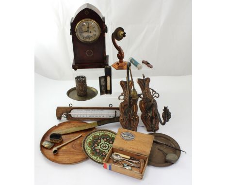
An early 20th century mahogany inlaid dome-top eight-day mantel clock, gilded dial set with Roman numerals (af) and a quantity of metalware to include a pair of Art Nouveau wall-mounted electroliers, an F Pastorelli of London small wall barometer and a wooden page turner with calendar dated 1898 with decorative map of the Russian Empire.
-
109182 item(s)/page