We found 109198 price guide item(s) matching your search
There are 109198 lots that match your search criteria. Subscribe now to get instant access to the full price guide service.
Click here to subscribe- List
- Grid
-
109198 item(s)/page


Lot 386
JOHN GREAVES NALL: GREAT YARMOUTH AND LOWESTOFT - CHAPTERS ON THE EAST ANGLIAN COAST PART I GREAT YARMOUTH AND LOWESTOFT; THEIR TOPOGRAPHY, ARCHAEOLOGY, NATURAL HISTORY, &C AND THE HISTORY OF THEIR FISHERIES - PART II THE DIALECT AND PROVINCIALISMS, London, Longmans, Green, Reader & Dyer, 1866, 2 volumes, folding road map from Cromer to Southwold (a/f), part loss and repair/reinforcement, + folding plan of Great Yarmouth + 5 plates, uniform original publishers green cloth gilt (2)
![LEWIS HEPWORTH & CO LTD (PUBLISHED): PICTURES OF GREAT YARMOUTH AND NEIGHBOURHOOD, [56]pp, full page black and white illustra](https://cdn.globalauctionplatform.com/e827cff2-f6b9-4f46-8706-a8b900c8abe2/5fb7b7c0-0c32-4ec0-a2b3-9257865082a6/468x382.jpg)
Lot 388
LEWIS HEPWORTH & CO LTD (PUBLISHED): PICTURES OF GREAT YARMOUTH AND NEIGHBOURHOOD, [56]pp, full page black and white illustrations from photographs throughout as called for, oblong quarto, original pictorial wraps worn, inner joints reinforced + JARROLD & SONS LTD FOR THE CORPORATION (PUBLISHED): GREAT YARMOUTH AND GORLESTON ON SEA, THE PREMIER EAST COAST HOLIDAY RESORTS, Official guide for 1938, 120pp, numerous illustrations throughout including large folding coloured plate of "The Marina" etc, original printed wraps + W M BYLES & SONS FOR THE CORPORATION (PUBLISHED): GREAT YARMOUTH AND GORLESTON ON SEA, THE FINEST SANDS IN GREAT BRITAIN, Official guide 1939, 128pp, folding map loosely inserted, numerous illustrations throughout including large folding coloured plates depicting Gorleston's new floral hall and swimming pool etc, original printed wraps + A W & J L ECCLESTONE: THE RISE OF GREAT YARMOUTH, THE STORY OF A SANDBANK, Great Yarmouth and Norwich, Jarrold & Sons Ltd for A W Ecclestone, 1959, 1st edition, original cloth gilt, dust-wrapper (4)

Lot 393
ARTHUR HENRY PATTERSON: 8 titles: NATURE IN EASTERN NORFOLK, illustrated Frank Southgate, 1905, 1st edition, 12 coloured plates + black and white map as called for, original cloth gilt; MAN AND NATURE ON TIDAL WATERS, 5 illustrations on 4 full page plates + 26 illustrations in text as called for, original cloth gilt; NOTES OF AN EAST COAST NATURALIST, illustrated Frank Southgate, 1904, 1st edition, 12 coloured plates as called for, original cloth gilt; WILD LIFE ON A NORFOLK ESTUARY, 1907, 1st edition, 40 illustrations as called for (of which several full page plates and full page maps), original cloth gilt; WILD-FOWLERS AND POACHERS, 50 YEARS ON THE EAST COAST, 1929, 1st edition, 12 illustrations on 8 full page plates + map front end papers and illustrations in text as called for, original cloth gilt; IN NORFOLK BIRD HAUNTS IN AD1755, Holt, Rounce & Wortley, 1930, 1st edition, 18 illustrations as called for, original cloth; FROM HAYLOFT TO TEMPLE, THE STORY OF PRIMITIVE METHODISM IN YARMOUTH, London, Robert Bryant, 1903, 1st edition, numerous in text illustrations as called for, original blind stamped cloth gilt; A NORFOLK NATURALIST, OBSERVATIONS ON BIRDS, MAMMALS AND FISHES, 1930, 1st edition, frontis + 35 illustrations as called for, original cloth gilt + STANLEY A MANNING: BROADLAND NATURALIST, THE LIFE OF ARTHUR H PATTERSON, (ALS "JOHN KNOWLITTLE"), Norwich, 1948, 1st edition, original cloth gilt (9)

Lot 415
JOHN WODDERSPOON: MEMORIALS OF THE ANCIENT TOWN OF IPSWICH, IN THE COUNTY OF SUFFOLK, Ipswich, Pawsey and London, Longman, Brown et al, 1850, 1st edition, coloured frontispiece + coloured map + 14 full page illustrations and two illustrations in text as called for, rebound half calf, new end papers, contemporary morocco gilt spine title label retained

![CHRISTOPHER SAXTON/WILLIAM KIP: CAMBRIDGE COMITATUS [CAMBRIDGESHIRE], engraved hand coloured map, circa 1607, approx size 280](https://cdn.globalauctionplatform.com/e827cff2-f6b9-4f46-8706-a8b900c8abe2/e286e16f-4ffa-4a76-92e7-05b905541303/468x382.jpg)

Lot 420
CHRISTOPHER SAXTON: NORFOLCIAE COMITATUS CONTINENS IN SE OPPIDA MERCATORIA 26, PAGOS ET VILLAS 625, UNA CUM SINGULIS HUNDREDIS ET FLUMINIBUS IN EODEM, VERA DESCRIPTIO, CORNELIUS HOGIUS SCULPSIT ANNO DNI 1574 [NORFOLK], engraved hand coloured map, 1574 (but later, printed circa 1579), early issue, engraved by Cornelis de Hooghe, Arms of Queen Elizabeth and Thomas Seckford, instigator of the atlas project and Saxton's patron, with his motto "Pestis Patriae Pigricies" above his Coat of Arms, ornamental cartouche upper left hand corner, index of hundreds upper right hand corner and scale of distance lower right hand corner, sailing ships and sea monster, first printed map of Norfolk and of any individual English county forming the precedent for most 17th century maps of Norfolk, close trimmed and laid down on paper (not recent), some small surface losses of paper, approx size 335 x 495mm, unframed and unmounted
![JAN JANSSON: NORTFOLCIA VERNACULE NORFOLKE [NORFOLK], engraved map, circa 1646, approx size 380 x 490mm, unframed and unmount](https://cdn.globalauctionplatform.com/e827cff2-f6b9-4f46-8706-a8b900c8abe2/cf643e09-3344-4a44-b9e8-6410774bca52/468x382.jpg)

Lot 422
JOHN SPEED: NORFOLK, engraved hand coloured map, circa 1631, "Discribed by Christopher Saxton augmented by I Speede, are to be sold in Pope's Head Alley by J S & G H", inset plan of the City of Norwich and inset view depicting a battle, approx size 365 x 490mm, framed and glazed, the whole approx size 530 x 630mm (appears laid down, close margins, faults)

Lot 423
EMANUEL BOWEN: NORFOLK DRAWN FROM SURVEYS AND BEST AUTHORITIES, engraved hand coloured map, 1753, approx size 165 x 190mm, framed and glazed, the whole approx size 290 x 325mm + EMANUEL BOWEN AND JOHN OWEN: A MAP OF NORFOLK, engraved hand coloured map, 1720, printed area approx 180 x 115mm, road strip map Harwich to Ixworth verso, framed and glazed, the whole approx size 310 x 230mm (2)

Lot 424
JOHN ELLIS: A MODERN MAP OF NORFOLK, DRAWN FROM THE LATEST SURVEYS; CORRECTED AND IMPROVED BY THE BEST AUTHORITIES, engraved hand coloured map, 1766, approx size 180 x 240mm, framed and glazed, the whole approx size 230 x 280mm + THOMAS KITCHIN: A MAP OF NORFOLK, engraved hand coloured map, 1749, approx size 120 x 120mm, framed and glazed, the whole approx size 295 x 255mm (2)
![CHRISTOPHER SAXTON/WILLIAM KIP: NORFOLCAE COMITATUS [NORFOLK], engraved hand coloured map, [1610], approx size 265 x 386mm, f](https://cdn.globalauctionplatform.com/e827cff2-f6b9-4f46-8706-a8b900c8abe2/01ff444c-ec06-4f8b-b525-054ba87fcbb8/468x382.jpg)
![ROBERT MORDEN: NORFOLK, engraved hand coloured map [1695], approx size 370 x 570mm, framed and glazed, the whole approx size](https://cdn.globalauctionplatform.com/e827cff2-f6b9-4f46-8706-a8b900c8abe2/418c45ea-9be6-4ba3-ba2f-a368b59267ce/468x382.jpg)
![RICHARD BLOME: A MAPP OF THE COUNTY OF NORFOLCK [NORFOLK]; WITH ITS HUNDREDS, engraved map, [1673], approx size 240 x 325mm,](https://cdn.globalauctionplatform.com/e827cff2-f6b9-4f46-8706-a8b900c8abe2/ba730954-5ff2-4022-828a-d544bff7a0ae/468x382.jpg)


![JOHN SENEX: THE ROAD FROM KING'S LYN [KING'S LYNN] TO NORWICH CONTINUED TO YARMOUTH IN NORFOLK, engraved hand coloured road s](https://cdn.globalauctionplatform.com/e827cff2-f6b9-4f46-8706-a8b900c8abe2/54101df1-5f68-4a47-d60d-c61e94c49a38/468x382.jpg)

Lot 431
CARINGTON BOWLES (PUBLISHED): A SURVEY OF THE ROAD FROM KING'S LYNN IN NORWICH CONTINUED TO YARMOUTH IN NORFOLK,,, A SURVEY OF THE ROAD FROM MONMOUTH TO LLANBEDER COMMENCING AT MONMOUTH IN THE ROAD TO ST DAVIDS,,,, engraved road strip map circa 1781, approx size 285 x 340mm, framed and glazed, the whole approx size 415 x 520mm

Lot 440
NICHOLAS SANSON: ANCIENS ROYAUMES DE KENT, D'ESSEX, ET DE SUSSEX,,,AVECQ LE PAS DE CALAIS, ET PARTIE DES COSTES DU PAYS BAS, DE PICARDIE, ET NORMANDIE, engraved hand coloured map, 1654-1667, covering the Channel coasts of England and France showing part of Suffolk and all of Essex, approx size 350 x 465mm, unframed and unmounted, good margins

Lot 441
ROBERT MORDEN AND JOSEPH PASK: EAST ANGLIA, circa 1690, (Section) from large scale map of England and Wales, map covering East of England coastline from Hornsey [Hornsea, Yorkshire], to Harwich, showing Norfolk, Suffolk, Cambridgeshire and parts of Essex, Lincolnshire and Yorkshire, decorative engraved cartouche and decorative engraved border to right hand side, engraved ship and sea creature in North Sea, printed area approx size 440 x 560mm, unframed and unmounted, good margins
![ROBERT MORDEN: SUFFOLK, engraved hand coloured map, [1695], approx size 350 x 410mm, unframed and unmounted](https://cdn.globalauctionplatform.com/e827cff2-f6b9-4f46-8706-a8b900c8abe2/9c877dd7-dfc3-45ab-f074-825d58eb37e9/468x382.jpg)
![JOHN SPEED: SUFFOLKE DESCRIBED AND DIVIDED INTO HUNDREDS,,,[SUFFOLK], engraved hand coloured map, [1743], "Sold by Henry Over](https://cdn.globalauctionplatform.com/e827cff2-f6b9-4f46-8706-a8b900c8abe2/73919e7e-7f31-4611-db1d-43095870e0f0/468x382.jpg)
Lot 450
JOHN SPEED: SUFFOLKE DESCRIBED AND DIVIDED INTO HUNDREDS,,,[SUFFOLK], engraved hand coloured map, [1743], "Sold by Henry Overton at The White Horse without Newgate, London", with engraved main roads, inset plan of Ipswich, cartouche and flanked by Coats of Arms, approx size 370 x 500mm, mounted, the whole approx size 570 x 695mm


Lot 384
Postal History: Useful loose selection from early 1800s to early 1900s in small carton, mostly stampless O.H.M.S. outer letter sheets (some fronts only) from 1860s and 1870s, these often with fine to very fine oval town date stamps including Amonteur, Port Beaufort, Prince Albert, Humans-Dorp, Somerset East, Claremont, Riversdale, Grahams Town, Halk Bay, Whittlesea, Montague, Ebenezer, Malmesbury, Pearston, Simons Town, Graf Reinett, Avontuur, Fraserburg, George, Worcester, Wolve-kraal and Alice, also several undated 'crown' circular town marks including Bathurst, a few early documents, some OLS franked 4d blue triangulars and some other odds including a copy of an original hand-drawn map relating to the defence of Mafeking in 1900, condition mixed (200+)
Lot 61
Antarctica: 1954 Expedition commemorative labels, a group of four large format (approx. 228mm x 133mm) artist's essays in black pen and ink on stout card including Ski-Plane over camp site, Expedition Vessel, Penguins and Map of Antarctica, some with additional alterations in Chinese white, also an additional 'Map' essay with background in pale blue, this with a number of pencil annotations in margins, largely fine and most unusual


![NO RESERVE Russia.- [Atlas of European Russia], title and index map, with 22 regional maps, all text in Cyrillic, lithographs](https://cdn.globalauctionplatform.com/33ea53be-1946-4bbd-a219-a8c40111b435/8e04780a-6228-49a8-ad5c-a53ef695397a/468x382.jpg)
Lot 104
NO RESERVE Russia.- [Atlas of European Russia], title and index map, with 22 regional maps, all text in Cyrillic, lithographs printed in colour, presented loose in parts, various sizes, largest 360 x 230 mm. (14 1/4 x 9 in), in original cloth covers, titled on upper cover, 8vo, worn, [20th century].

Lot 106
World.- Moll (Herman) Thirty Two New and Accurate Maps of the Geography of the Ancients, additional double-page engraved title, 32 engraved double-page and folding maps, occasional small tears to folds, map 30 torn and incomplete, occasional spotting, lacking free endpapers, later half calf, rubbed, H. Moll; and Tho. Bowles, 1732 § Walker (J. & C.) [The British Atlas], lacking title, 49 hand-coloured double-page engraved maps, previous owner's ink inscriptions, occasional faint off-setting, faint marginal water-stain to last few maps, contemporary half morocco, rubbed and worn, 1873 § Cary (John) Cary's Six Sheet Map of England and Wales, with Part of Scotland, hand-coloured engraved map, six sheets mounted as 3 on linen, each approx. 470 x 1055 mm. (18 1/2 x 41 1/2 in), faint spotting, presented in a slip-case, rubbed and worn, 1836; and 2 others, incomplete atlases, v.s.; sold not subject to return (5).

Lot 109
Britain.- Cary (John, publisher) Cary's New Map of England and Wales with Part of Scotland, engraved title, hand-coloured general map and 79 sheets (numbered 1-81), mostly maps hand-coloured in outline but including dedication, key & scale as part of sheets, no sheets numbered 62 or 80 as often (presumably unnumbered title and general map), light offsetting, contemporary tree calf, worn, lacking lower cover (replaced with another board), covers detached, 4to, John Cary, 1794.

Lot 113
NO RESERVE British Isles.- Lewis (Samuel, publisher) A Map of England and Wales, Divided into Counties, Parliamentary Divisions, & Dioceses, presented in four sections, covering the North East, South East, North West, and South West of England, with large decorative title upper right in the North East section, and large engraved view of The General Post Office London upper left in the North West, the view by Griffiths after Allom, engraved folding maps, drawn by R. Creighton, and engraved by J. Dower, each dissected and mounted on linen, all with hand-colouring, each approx. 1060 x 880mm., occasional surface dirt and spotting, folding into original red straight-grain morocco, gilt decorated borders, 8vo, edges rubbed, spines faded, S. Lewis & Co., 1840, (4).
Lot 115
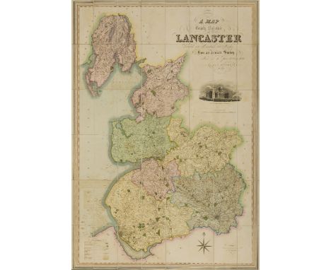
NO RESERVE Lancashire.- Hennet (George, surveyor) A Map of the County Palatine of Lancaster, large map with ornate title upper right, vignette view of the New Custom House, Liverpool, just below, engraved map by James Bingley, with bright original hand-colouring, 1630 x 1160 mm. (64 1/4 x 45 3/4 in), dissected and mounted on linen, edged with green silk, very slight offsetting and browning, minor surface dirt, folding with green marbled endpapers, presented in tree calf book-style slipcase, rubbed, spine with red morocco label gilt-lettered 'Teesdales Map of Lancashire', 4to, Henry Teesdale, 1830.
Lot 67
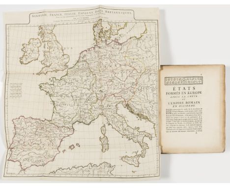
NO RESERVE Europe.- Anville (Jean Baptiste Bourgignon d') États formés en Europe après la chute de l'Empire Romain en Occident, first edition, large folding engraved map by Guillaume-Nicolas de la Haye, hand-coloured in outline, woodcut head- and tail-pieces and initials, occasional spotting, modern calf, 4to, Paris, L'Imprimerie Royale, 1771.

Lot 86
Fonthill Abbey.- Rutter (John) Delineations of Fonthill and its Abbey, hand-coloured aquatint additional pictorial title, 12 engraved plates (2 being hand-coloured aquatints) and 1 folding lithographed map at end, plate guards, double-page genealogical table, wood-engraved vignettes, slightly foxed and browned, stain affecting Appendix C at end, , modern ink signature on fly-leaf, bookplate on front pastedown, contemporary half calf, gilt, slightly rubbed, gilt spine, sm. 4to, 1823.
Lot 93
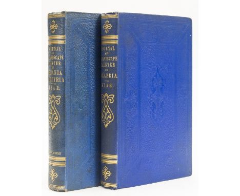
Albania.- Lear (Edward) Journals of a Landscape Painter in Albania, map and 20 tinted lithographed plates, 2 bookplates on front endpapers, [Abbey, Travel 45], 1851; Journals of a Landscape Painter in Southern Calabria, 2 parts in 1, half-titles, 2 lithographed maps and 20 tinted lithographed plates, [Abbey, Travel 175], 1852, first editions, some foxing and browning, heavy in places, original blue blind-stamped cloth, gilt spines, slightly dulled, edges uncut, 8vo (2).
![NO RESERVE New Zealand.- Australia.- ["Eve in Wonderland": Photographic Album], cracked hinges, 1907; [Photographic Views of](https://cdn.globalauctionplatform.com/33ea53be-1946-4bbd-a219-a8c40111b435/2dc6e48d-b3ae-4c8a-c88c-6eedce0b8d79/468x382.jpg)
Lot 96
NO RESERVE New Zealand.- Australia.- ["Eve in Wonderland": Photographic Album], cracked hinges, 1907; [Photographic Views of Tauranga], 1909; c.105 early gelatin silver prints mounted on card, manuscript titles to each card, original cloth, manuscript titles to upper covers, rubbed and a little soiled § Johnston (William & Alexander Keith) Emigration Map Queensland, Australia, title upper left, with inset map of the world highlighting Australia, lithographed map, 695 x 515 mm. (27 1/4 x 20 1/4 in), dissected and mounted on linen, some folds splitting, folding into original green cloth decorated in gilt, rubbed and worn, 8vo, 1865 (3)⁂ The album's include images of Rotorua and Tauranga on the North Island of New Zealand.
Lot 97
Brazil.- Gardner (George) Travels in the Interior of Brazil ... and the Gold and Diamond Districts, first edition, tinted lithographed frontispiece, map, damp-stain to upper corner, light spotting and soiling, cracked hinges, original cloth, rubbed, small loss to spine extremities, 1846 § Smith (Herbert H.) Brazil: the Amazons and the Coast, folding map, small tape repairs, illustrations, ex-library with small ink-stamp to title verso, occasional spotting and finger-soiling, occasional ink marginal markings, pp.15-16 foredge strengthened, new endpapers, original cloth, browned spine, a little rubbed, c.1879; 8vo (2)

Lot 51
Map of South Africa, dated March 1901, hand drawn by Thomas Brassington, with extensive annotations and Union Jack flag in bottom left corner, ink and watercolour, 43 x 60.5cm, 17 x 23.75in. Condition Report: The painting is in good, original condition with strong colours. The paper has browned slightly in areas and there is the odd spot of foxing and browning across the painting. The painting is framed and glazed.


-
109198 item(s)/page