We found 109182 price guide item(s) matching your search
There are 109182 lots that match your search criteria. Subscribe now to get instant access to the full price guide service.
Click here to subscribe- List
- Grid
-
109182 item(s)/page


Lot 1251
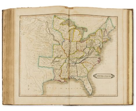
A sale particulars relating to Moccas Estate 1919, in the Parishes of Dorstone, Peterchurch and Bredwardine, includes the following properties: The Cabin, The Beddw, Penlan Farm, The Bell Farm, Dorstone Mill, Dorstone Court, Willmaston Farm, Great Llanavon, The Lodge, and various other cottages and plots of land, listing buildings, pasture etc, with acreage. Contains folding map showing various properties in colour, 6" to 1 mile, 27" x 16" with pencilled notes, recording buyer and purchase price.


Lot 104
MALCOLM (James) A Compendium of Modern Husbandry, principally written during a survey of Surrey, also . . . the neighbouring Counties . . . Kent, Sussex, &c., 3 vols, folding hand-col’d map frontis in vol. 1, 6 plates, calf (rebacked, recased, 1st Edn., L., 1805; BROWN (Robert) A Treatise on Agriculture and Rural Affairs, 2 vols, 8vo, 6 engr. plates, calf, Edinburgh, 1811 (5)

Lot 125
NAPIER (William John) A Treatise on Practical Store-Farming as applicable to the mountainous region of Etterick Forest, 8vo, folding map frontis., 2 plates, folding table, half calf, 1st Edn., Edinburgh, 1822; ROBERTSON (George) Rural Recollections, 8vo, frontis (reattached), 1 plate, later quarter calf, Irvine, Cunninghame Press for the Author, 1829 (2)


Lot 33
BROWN (Robert) General View of the Agriculture of the West Riding of Yorkshire, 8vo, folding map frontis., speckled calf (edges rubbed, hinges cracked), 1st Edn., Edinburgh, 1799; RENNIE, BROUN, & SHIRREFFGeneral View of the Agriculture of the West Riding of Yorkshire, 4to, 1 map, L., Bulmer, 1794, [bound in recent half calf with:] LEATHAM (I.) General View of the Agriculture of the East Riding of Yorkshire, hand-col’d map, 7 plates, L., Bulmer, 1794 [and] TUKE (John) General View of the Agriculture of the North Riding of Yorkshire, hand-col’d map, L., Bulmer, 1794 (2)The second work comprises three seminal texts on Yorkshire agriculture, printed by London’s foremost printer of the day.


Lot 263
AN ANTIQUE PRINTED MAP BY J. STOCKLEIN, Augsburg 1726. Nagasaki So Sie Sineser Tschangki Nennen. Copperplate Uncoloured. This detailed and uncommon plan of Nagasaki appeared in an account of recent voyages and travels compiled by Joseph Stocklein (ft. 1726 - 1748), a Jesuit priest, and based on that by Jean de Fontaney's whose Lettres édificantes et curieuses contained records of his time in China and south east Asia, first published in Paris in 1708. (Walter 95.) This is an unusual and early map of the Japanese trading port of Nagasaki, the main trading port in Japan for the Dutch East India Company, and, at this time, the sole point of contact between Japanese traders and European merchants. A lettered key identifies 12 locations of significance. 235 by 140mm (9.25 by 5.5 inches)

Lot 264
AN ANTIQUE PRINTED MAP 'JAPAN' BY A. ARROWSMITH, London 1802. Steel plate Uncoloured. An interesting, clear and detailed map of Japan, excluding Hokkaido but including a blank outline of Korea. The names of the provinces, and surrounding islands, are given. Aaron Arrowsmith (1750-1823) was an English mapmaker and member of theArrowsmith family of geographers, arguably the best and most influential mapmakers of the period. This map is distinctive for its unusual background shading of the sea areas, highlighting the islands' shapes. 250 by 200mm (10 by 8 inches).

Lot 265
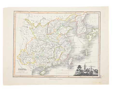
ANTIQUE PRINTED MAP 'CHINA' BY J. & C. WALKER, London 1843 - 1844. Attractive hand-colour. This interesting and detailed map of China was published in the atlas volume published as 'Maps of The Society for the Diffusion of Useful Knowledge London: Chapman and Hall, 186, Strand. The Society was one of many Victorian charitable institutions established to educate and inform a newly literate working class. The map's sub-title states 'The Interior Chiefly From Du Halde And The Jesuits 1710 To 1718 And The Sea Coast From Modern Authorities', indicative of the lack of advancing European knowledge over the previous one hundred but of the increasing naval activity in the area. 310 by 390mm (12 by 15.25 inches).

Lot 266
AN ANTIQUE PRINTED MAP BY J. N. BELLIN, Paris 1752. PLAN DE LA VILLE DE MEACO. Copperplate Uncoloured. A well engraved and detailed plan of the port and city of Meaco, present-day Kyoto. Jacques Nicolas Bellin was the leading French hydrographer of the mid-eighteenth century, best known for his chart books and the maps prepared for inclusion, as in this instance, in L'Abbe Prevost's 'Histoire Generale Des Voyages'. Based on the latest reports and publications, this copies the larger format plan by Scheuchzer of about 25 years earlier and demonstrates clearly the rectilinear arrangement of streets. 195 by 275mm (7.75 by 10.75 inches).

Lot 268
AN ANTIQUE PRINTED MAP 'DE STADT OSACCO', Leiden 1669- BY A. MONTANUS. Copperplate Uncoloured. A fascinating and detailed panoramic view of Osaka in Japan. The city is shown from the sea and a 24 point numbered key (in Dutch) identifies buildings and locations of note. The plate first appeared in Arnold Montanus' book on Japan and was later reissued. 260 by 690mm (10.25 by 27.25 inches).

Lot 272
ANTIQUE PRINTED MAP BY SIR JOHN BARROW, London 1797. A chart on Mercator's Projection containing the Track and surroundings of the Lion, the Hindostan and Tenders, from Turon-Bay in Cochin-China to the mouth of the Pei-Ho River in the Gulph of Pe-Tche-Lee of Pekin. Copperplate coloured. The first British Embassy to the Emperor of China, 1792-4, was led by the First Earl Macartney whose comptroller Sir John Barrow, cartographer was later a co-founder of the Royal Geographical Society. The official report by Sir George Staunton, in which this chart appeared, was published in 1797. Here are the tracks of the Embassy as it progressed from Turon Bay in Cochin China, past the site of present-day Hong Kong, to the Gulf of Peking (now Beijing). The Hindostan and Lion and her tenders parted company in the fog, and were separated from around the 12th July, 1793 to about the 16th July. The purposes of the Embassy were to establish, by negotiation with the Emperor,a British trading post and a permanent embassy, at the same time easingrestrictions on Anglo-Chinese trade. 710 by 495mm (28 by 19.5 inches).

Lot 273
AN ANTIQUE PRINTED MAP 'IAPONIA REGNUM' BY M. MARTINI, J. BLAEU, P. MORTIER, Amsterdam 1655-c.1700. Copperplate, original outline colour. An elegant and finely engraved map of Japan, important and influential. The Great Wall of China appears at the far left; Christian communities in Japan are marked with a cross; two volcanic islands are shown with smoke. Geographic details were probably informed by material which the author Martini collected in China. The Dutch place-names in the north-east of the islands and detail of the Izu islands were probably added by Martini's publisher, Blaeu, from charts of the Dutch East India Company. This example is an alternate state with the names of De Wit and Mortier added; the copperplates for Blaeu's Atlas Sinensis were sold at auction to various printers. 425 by 575mm (16.75 by 22.75 inches)This example has been laid on archival tissue and is trimmed close with protective margins added for mounting.A little age-toning but an attractive example.
Lot 274
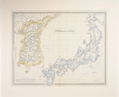
ANTIQUE PRINTED MAP BY G. PHILIP COREA AND JAPAN London c. 1859. Lithograph, original Colour. This interesting map of Korea and Japan was published in 'The Philips New General Atlas', George Philip & Son London & Liverpool. Notes on the Corean Archipelago feature in the lower left hand corner. The map is surrounded by a distinctive and decorative piano-key border. 520 by 640mm (20.5 by 25.25 inches)

Lot 275
ANTIQUE PRINTED MAP BY F. F. DE LA PEROUSE, Paris 1797. Carte des Decouvertes, Faites en 1787 dans les Mers de Chine et De Tartaire... 2E Feuille; Copperplate, uncoloured. Comte De La Perouse continued the French tradition of Pacific exploration. He followed Cook's scientific and geographic approach, not aiming for commerce or land annexation. Unlike Cook, he made no major land finds. This detailed second sheet continues the track of La Perouse's voyage from north Korea and Japan around Kamchatka and the Kurile Islands. 490 by 675mm (19.25 by 26.25 inches)
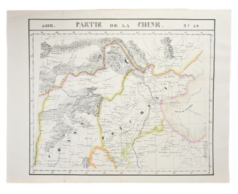
Lot 277
ANTIQUE PRINTED MAP 'ASIE PARTIE DE LA CHINE NO. 59' BY P. M. VANDERMAELEN, Brussels 1827. Lithograph Original outline colour. Philippe Vandermaelen's 'Atlas Universelle' was the first world atlas to be produced at a uniform scale, one of the earliest produced by lithography and showed all areas of the world. On this sheet the cartographic detail shows good detail of the provinces to the south and south west of Beijing (then Peking). One of the most detailed depictions of the area to this date. 475 by 565mm (18.75 by 22.25 inches)
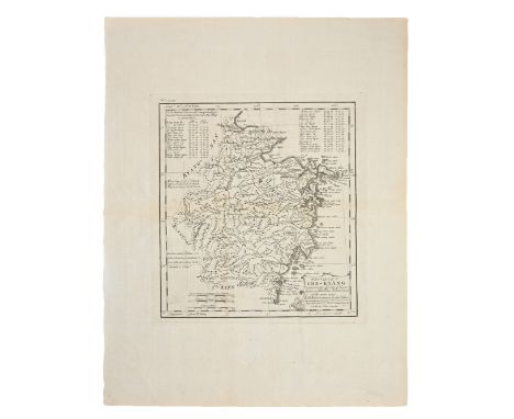
Lot 279
AN ANTIQUE PRINTED MAP BY J. B. DU HALDE / E. BOWEN, London 1738. PROVINCE V. CHE-KYANG; DRAWN ON THE SPOT ... IN THE YEAR 1714. Copperplate Uncoloured. Very detailed map of this Chinese province, from the manuscript map compiled by Regis, de Mailla and Henderer, three missionaries, in 1714. There is a table of the latitude and longitude for the principal cities of the province. 255 by 230mm (10 by 9 inches).
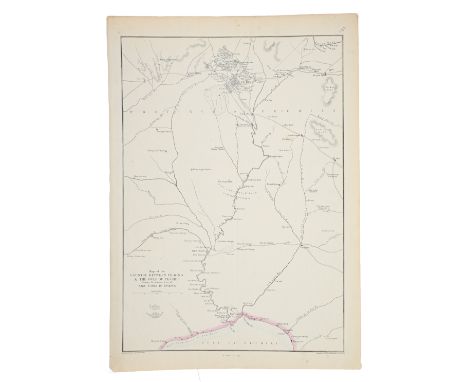
Lot 282
AN ANTIQUE PRINTED MAP BY E. WELLER, London c. 1860. MAP OF THE COUNTRY BETWEEN PE-KING & THE GULF OF PE-CHILI. Lithograph Original outline colour. An uncommon and interesting detailed map from the area around Peking to present-day Tianjin on the coast. Clearly marked is the river system linking the two cities, adjacent canals and roads. Also indicated are temples and palaces around Beijing. Edward Weller engraved and lithographed this map for later editions of the series of maps issued as the "Weekly Dispatch" atlas. 305 by 435mm (12 by 17.25 inches).
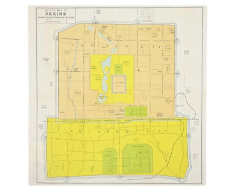
Lot 283
AN ANTIQUE SKETCH MAP OF PEKING DRAWN FOR CROW'S 'HANDBOOK FOR CHINA' BY C. CROW, New York, Dodd, Mead & Co. 1933. Lithograph Coloured. An uncommon and interesting early tourist plan of Beijing, (Peking) China, published for Carl Crow's 'Handbook for China'. The text is in English, and the simple plan gives a key showing temples, churches and missions. 300 by 275mm (11.75 by 10.75 inches).
Lot 286
AN ANTIQUE PRINTED MAP 'CHINA' BY J. WYLD / J. THOMSON, London 1825. Copperplate Original colour. An attractive nineteenth-century map of China with a vignette view of a Chinese village at lower right. The map was published in 'A General Atlas, Containing Maps Illustrating Some Important Periods In Ancient History: And Distinct Maps Of The Several Empires, Kingdoms And States, In The World From Original Drawings, According To The Latest Treaties". James Wyld's maps were engraved by N.R.Hewitt in London and were published by John Thomson & Co. In Edinburgh - the maps bear the imprint of author, engraver and publisher in the lower margin. James Wyld (Senior) was a renowned English mapmaker who went on to become Geographer to His Majesty and was a founder member of the Royal Geographic Society. These maps represent some of his early work andillustrated his skill and the professional respect which it earned.290 by 215mm (11.5 by 8.5 inches).

Lot 287
AN ANTIQUE PRINTE MAP BY J. N. BELLIN C.1764. CARTE DE L'ISLE DE CHEU CHAN OU ISLE DE CHUSAN De la Province de Che-kiang. Avec les Costes et Isles voisines. Copperplate Uncoloured. This detailed chart is orientated with north to the right, and shows Ning-po (Ningbo) at top with area east below it, in the province of Chekiang, across the bay from Shanghai. From an edition of Prevost's 'Histoire des Voyages'. 220 by 320mm (8.75 by 12.5 inches).
Lot 291
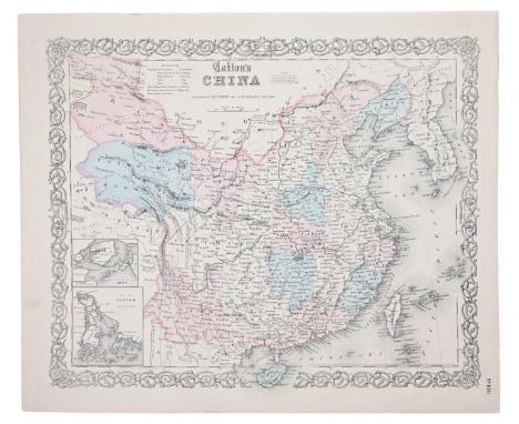
AN ANTIQUE PRINTED 'COLTON'S CHINA' BY J. H. COLTON, New York 1855 - c.1860. Lithograph Original colour. An attractive and detailed map, published in New York showing China extending well into central Asia. Inset details show Canton and adjacent islands including Hong Kong, and on a separate map Amoy. Elegant entwined design border. 325 by 400mm (12.75 by 15.75 inches).
Lot 296
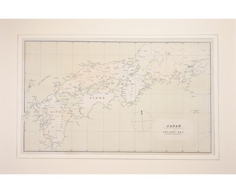
AN ANTIQUE PRINTED MAP 'JAPAN INLAND SEA' London C.1870-; Lithograph Original colour. A finely produced map of southern Japan, focusing on the area known as The Inland Sea - the waterways between the islands of Honshu, Kyushu and Shikoku, and now recognised as a resort destination on account of its scenery and tranquillity. Internal detail is confined to the boundaries of provinces and coastal cities, and, in the sea to the northwest is marked 'East Korea Strait'. An unusual large-scale map presumably produced for an early guide book to the region. 340 by 580mm (13-5 by 22.75 inches).
Lot 297
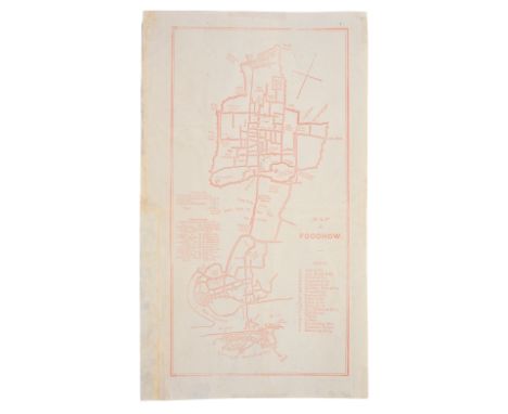
AN ANTIQUE PRINTED MAP BY W. F. MAYERS, London / Hong Kong 1867. MAP OF FOOCHOW. Lithograph uncoloured. William Frederick Mayers was one of a number of British Consular officials active in the major ports and towns in the Far East during the mid-nineteenth century. His work 'Treaty Ports Of China and Japan' was a source of much valuable information for visitors whether in the pursuit of trade or as tourists, and included detailed folding maps of many of those trading ports featured. This map shows in good detail the town of Foochow, Fuzhou in the Province of Fujian, situated on the east coast. Numbered and lettered keys identify 24 'Residences', ie important foreign trade offices, missions etc and 26 "Hong's" or marketplaces. 295 by 150mm (11.5 by 6 inches). Printed in light scarlet ink on thin rice paper with backing to old fold weakness but very acceptable.
Lot 298
AN ANTIQUE PRINTED MAP BY N. BELLIN / J. VAN SCHLEY, Paris / Amsterdam c.1770. CARTE DE LA BAYE DEHISCE ...; Copperplate coloured. This chart for a Dutch edition of Prevost's 'Histoire des Voyages' first appeared in 'Le Petit Atlas Maritime' which shows the mouth of the Chiang River in the Fujian Province of modern day China. It covers part of the modern day city of Fuzhou on the southeastern coast of China just west of Taiwan or Formosa. Very detailed, it also features towns, fortifications, islands, bridges, rivers and mountains. Depth soundings around the coastline are also marked. 220 by 275mm (8.75 by 10.75 inches).

Lot 299
AN ANTIQUE PRINTED MAP BY LAURENT, Paris c.1780. CARTE DES ISLES KOU RILES DAPRES LE CARTE RUSSE. Copperplate Uncoloured. Detailed and early map showing northern Hokkaido, part of Japan, the adjacent coastline of Sakhalin and the islands of the Kurile group extending northwards. From an edition of Prevost's 'Histoire Generale des Voyages'. 240 by 270mm (9.5 by 10.75 inches).


Lot 190
Staden, Hans: De voorname Scheeps-togten na Brazil, gedaan Anno 1547 en 1549. Nu eerst uyt' Hoogduytsch vertaald na den egten laatsten vermeerderden derden Druk. Leiden: P. van der Aa o. J. (1706). 41,5 x 25,5 cm. Mit gest. Titelvign., 1 gefalt. Kupferkarte und 23 Textkupfern. 2 Bll., 76 Sp., 1 Bl. Mod. Ldr. mit Rv., Rs. und Filetenverg. auf den Deckeln. (Berieben und bestoßen. Etwas gebrauchs- und altersfleckig. Das Kupfer in Sp. 61/62 montiert. Restauriert mit wenigen Ergänzungen im w. Rand.)Sabin 90057. Alden 706/209. Borba de Moraes 786. - Auszug aus Pieter van der Aa's "De Aanmerkens-waardige voyagien door Francoisen ..., Bd. I". - "This edition ... was printed from the same setting of type as the preceeding octavo edition, rearranged to make two columns to a page ... all but one of the copper plates in the octavo edition are included as illustrations in the text of the folio. The map is printed on the same sheet with one of the other maps of this volume" (Sabin).
Lot 140
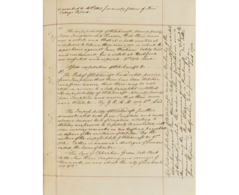
Hertfordshire.- Clutterbuck (Robert, local historian and landowner, 1772-1831) [Autograph manuscript notes relating to Hertfordshire], autograph manuscript notes signed on 13 pages, excerpts of 4 works on Hertfordshire in 1 vol., including by Thomas Cox (Magna Britannia) and Walker (General View on the Agriculture of the County of Hertford), engraved map of Hertfordshire by Robert Morden, browned, bookplate of Clutterbuck on front pastedown, 19th century half morocco, slightly rubbed, sm. 4to, printed text 18th - 19th centuries & manuscript [c. 1810].⁂ "The impossibility of Witchcraft, plainly proving from Scripture and Reason, that there never was a witch, and that it is both irrational & impious to believer there ever was in which the depositions against Jane Wenham lately tried and condemned, for a witch at Hertford are confuted and exposed. 8vo 1712. Lond." Provenance: Ink inscription of Andrew Coltée Ducarel (1713-85), librarian and antiquary.
Lot 172
Bible, English.- The Bible. That is the Holy Scriptures conteined in the Olde and Newe Testament, titles with woodcut illustration, general title with first two words of title within woodcut entablature, woodcut initials and numerous illustrations in text, double page woodcut plan depicting the temple at Jerusalem, double-page woodcut map of the Holy Land, general title mounted on stub with some restoration to inner margin, [Herbert 144, STC 2118], Christopher Barker, 1576 bound with The Whole Booke of Psalmes, collected into englishe by Thomas Sternh, title within architectural woodcut border, musical notation, final f. creased, [STC 2446], John Day, 1576 together 2 works in 1 vol., double column, ruled in red, the odd chip or tear to margin, occasionally straying into text but without significant loss, occasional light foxing or soiling, ink family notes to endpapers dating from the early 18th century, later morocco, gilt, fillet and roll borders, central decoration with ornamental thistles, neatly and sympathetically rebacked, retaining original backstrip, some rubbing, g.e., folio.⁂ A very good, complete copy of an early folio edition of the Geneva Bible, either the first or second to be printed in England.
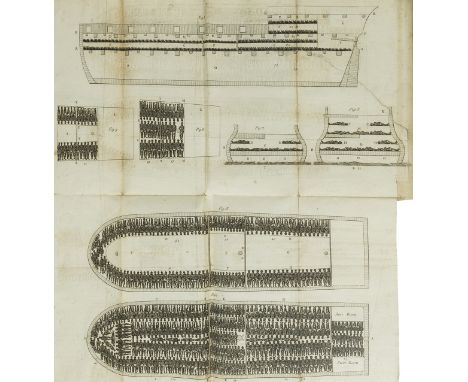
Lot 199
Slavery.- Clarkson (Thomas) The History of the Rise, Progress and Accomplishment of the Abolition of the African Slave-Trade by the British Parliament, 2 vol., first edition, 2 engraved plates, 1 folding with short tear, 1 folding map, 2N8 vol. 1 with short marginal tear and neat repair, C4 & N3 vol. 2 with tiny marginal hole, Z4 vol. 2 with short marginal tear, bookplate, previous owner's ink signature, cracked hinges, contemporary calf, a little rubbed, slight bumping to corners and extremities, [Goldsmiths 19725; Kress B.5319], 8vo, 1808.⁂ Thomas Clarkson (1760-1846) devoted most of his life to fighting for the abolition of slavery and toured the country assembling evidence, interviewing 20,000 sailors an acquiring equipment used on the slave-ships.
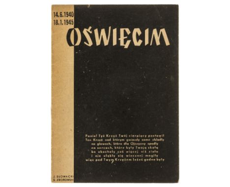
Lot 249
Opening speeches of the Auschwitz Museum in 1947.- Opieka nad Oświęcimiem, only edition, 16pp., illustrations, including a view of the entrance to the camp and an aerial map of Auschwitz, original wrappers, corners and extremities very lightly rubbed, light fading to spine but overall a very excellent copy, 8vo, Kraków, 1948.⁂ A rare and important document, marking the transition from Auschwitz as a concentration camp to its status as a museum. The publication follows the opening ceremony of the Auschwitz museum on June 14, 1947, the official date on which the Government of the Republic of Poland recognized the Auschwitz camp as a museum site. The pamphlet includes transcripts of speeches and letters from senior Polish government officials and survivors on the opening day in a special ceremony held on the day. Among the people appearing are Ryszard Stankowski, a former prisoner in Auschwitz who was a survivor at the end of the war having been on the death row, Dr. Mazimilion Kessler, Chief Executive Officer of the Warsaw Handloby Bank, Dr. Boleslav Rozmarinowicz, President of the Polish Guilds, and Dr. Kazimierz Rudnicki, Prosecutor of the Court of Appeal in Krakow, amongst others.
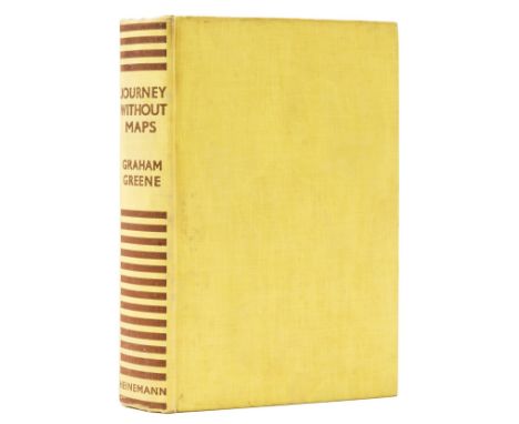
Lot 272
Greene (Graham) Journey Without Maps, first edition, photographic plates, map endpapers, edge spotting, light browning to endpapers, original cloth, light spotting and some splash marks to covers, but a very good, bright example overall, [Wobbe A11a], 8vo, 1936.⁂ Greene's first travel book and one of his rarest titles in first edition.
![Milne (A. A.) [The Christopher Robin books], 4 vol., comprising When We Were Very Young, first issue with contents page unnum](https://cdn.globalauctionplatform.com/7f555423-35bb-47ba-900e-af0400c3d8cc/82c28795-7d19-49ec-87b3-af07011e8aa4/468x382.jpg)
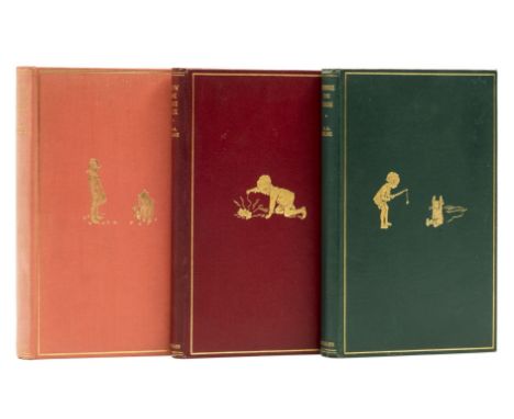
Lot 290
Milne (A. A.) [The Christopher Robin books], 4 vol., comprising When We Were Very Young, first issue with contents page unnumbered, neat ink ownership inscription and light browning to endpapers, slight sunning to spine, splash mark to upper cover, jacket with light toning to spine and panels, spine ends and corners a little chipped, 1 or 2 short tears with light creasing to head and foot, neat and professional tape repairs and strengthening to verso, extremities a little rubbed, preserved in custom drop-back box, 1924; Winnie-the-Pooh, map endpapers (very light browning), jacket with light toning to spine, neat and professional repairs and restorations to spine, corners and along upper fore-edge, repaired tear straying into upper panel, 1926; Now We Are Six, pictorial endpapers, spine slightly darkened, light toning to jacket spine and head of upper panel, spine with chip to foot, minor chipping to tip of spine and corners, some light surface soiling, short nick to head, 1927; The House at Pooh Corner, pictorial endpapers (very light browning), bookplate to endpaper, jacket spine with light toning, minor chipping and light creasing to spine tips and corners, 1928, first editions, illustrations by Ernest H. Shepard, original pictorial cloth, gilt, light rubbing to spine tips and corners, t.e.g., dust-jackets, an excellent set, 8vo.⁂ An attractive set of Milne's classic series.
Lot 291
Milne (A. A.) Winnie-the-Pooh, map endpapers, 1926; Now We Are Six, half-title browned, 1927; The House at Pooh Corner, very light sunning to spine,1928, first editions, illustrations by E. H. Shepard, one or two instances of light marginal spotting or finger-soiling, some browning to endpapers, original pictorial cloth, light bumping to spine ends, very slight shelf lean, overall bright and excellent copies, 8vo (3)

Lot 53
Balkans.- Reusch (Erhard) Alter und Neuer Staat des Königreichs Dalmatien, 2 parts in 1, double-page engraved frontispiece, title in red and black, 46 engraved plates, 2 folding, 1 folding map with short tears to folds, 1 folding text leaf, frontispiece detached with splits to fold and small loss to bottom edge, R8 in part 2 detached and loosely inserted, Z5 in part two with short marginal tear, scattered faint spotting and soiling, errata bound at end, occasional pencil marks and notes to blanks, cracked hinges, near contemporary half-vellum, spine defective but majority of contents holding firm, rubbed and worn, 8vo, Nürnberg, Conrad Monath, 1718.

Lot 66
Asia.- Münster (Sebastian) India Extrema XXIIII Nova Tabula, map of the continent showing from the Arabian Peninsula across India and Sri Lank to China and the Spice Islands, woodcut on laid paper with watermark of bishop's crozier, sheet 297 x 385 mm (11 3/4 x 15 1/4 in), Latin text verso with woodcut borders, small loss in the upper left corner, minor spotting and surface dirt, central vertical fold, unframed, Basel, [circa 1545]⁂ One of the earliest maps of the whole continent based on recent discoveries by Portuguese navigators.
Lot 67
Atlases.- Lizars (Daniel) Lizars' Edinburgh Geographical General Atlas, 68 double-page engraved maps, hand-coloured in outline, with 1 double-page 'Tables of Mountain Chains' map, all mounted on stubs, many with small tears at central fold, some with paper repairs (of which 1 affecting map), c.15 with staining at fold head (a few affecting map), gutter reinforced with tape at title, some light off-setting and spotting, contemporary cloth, rebacked in rexine, soiled and rubbed, folio, 1842.⁂ Including the two rare maps depicting the Republic of Texas between its secession from Mexico in 1836 and its annexation in 1845.

Lot 69
China.- Hondius (Jodocus) China, map of China showing from the Bay of Bengal, across to Korea and Japan, engraving with full hand-colouring heightened with gold, platemark 345 x 460 mm (13 1/2 x 18 1/8 in), sheet 493 x 590 mm (19 1/2 x 23 1/4 in), Latin text verso, even toning and some spotting, central vertical fold with minor splitting to upper section, unframed, [circa 1613-1619]
Lot 70
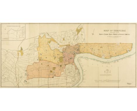
China.- North-China Daily News & Herald (publisher) Map of Shanghai, large English map focussing on the Shanghai International Settlement and the French Concession area, with 'Chinese City located underneath, with certain sites also identified outside of the settlement, including the Siccawei (Zikawei) Observatory and the Shanghai Jewish Club, with numerous businesses, schools, wharves, police stations, public works, and churches identified, and an inset "plan shewing the rubicon road system" in the upper left corner, lithograph printed in colours, 780 x 1540 mm (30 3/4 x 60 1/2 in), mounted on archival support, old folds with some associated splitting repaired, surface dirt, rolled, printed by Waterlow & Sons, 1918⁂ The North-China Daily News was an English-language newspaper in Shanghai, China.

Lot 71
China.- T'ou-sè-wè (Orphanage & Mission Press, Shanghai publisher) Plan de la Concession Francaise - Changhai, map of the developing Shanghai French Concession, showing from Nan Yang University across to the Hunagpu River in the east, including 'Shanghai City' in the lower right quadrant, with contemporary ink inscription in a French hand identifying a 'Dépot' in the lower centre of the map, lithograph printed in colours, sheet 355 x 750 mm (14 x 29 1/2 in), mounted on archival support, old folds with some minor splitting repaired, some spotting and surface dirt, unframed, rolled, Shanghai, 1927⁂ Scarce. We cannot trace any other known impressions of this map having been offered at auction.
-
109182 item(s)/page