

De Gelegentheyd van `t Paradys en `t Landt Canaan, Mitsgaders d`Eerst Bewoonde Landen der Patriarchen... This Dutch Bible map covers the region between the Mediterranean and the Persian Gulf, depicting numerous Biblical sites, including the wanderings of the Children of Israel and the Garden of Eden. The map is richly embellished with a banner style title cartouche and four corner vignettes - the creation of Adam and Eve, Paradise, Eve offering Adam the apple, and the expulsion from the Garden of Eden. At bottom center is a large scene of the Ark. The map was copied from Bastian Stoopendaal`s slightly larger map of 1688. Published by Jacob and Hendrik Keur in a Dutch bible. Dutch text on verso. A nice impression with attractive color, minor toning, and light printer`s ink residue. Issued folding with a short fold separation in bottom blank margin that has been closed on verso with archival tape. 11.9"" W x 17.5"" H Jagen, Jan van 1748
We found 109182 price guide item(s) matching your search
There are 109182 lots that match your search criteria. Subscribe now to get instant access to the full price guide service.
Click here to subscribe- List
- Grid
-
109182 item(s)/page

A New Map of Turkey in Asia This sharply engraved map is based on the cartography of the important French cartographer, Jean Baptiste Bourguignon d`Anville. It shows the region from Turkey to Iran and Armenia, and includes the Black and Mediterranean Seas and a portion of Europe. Syria, Cyprus, Kurdistan, Al Gezira, and Iraq are also noted. The topography, towns and caravan routes are noted on this detailed map. Original color with light offsetting and toning along the centerfold. A centerfold separation that enters 2.5"" into map at bottom has been archivally repaired. 20.6"" W x 28.4"" H Laurie & Whittle, 1794
![[Lot of 3] Turkey in Asia [and] Asia Minor [and] Turkey in Europe This lot of three steel engraved maps covers the area from](http://lot-images.atgmedia.com/SR/36385/2916721/600-2014116144833_468x382.jpg)
[Lot of 3] Turkey in Asia [and] Asia Minor [and] Turkey in Europe This lot of three steel engraved maps covers the area from the Adriatic to the Caspian Sea. Size varies slightly.A. Turkey in Asia. Decorative map that features three engraved vignettes: a large view of Jerusalem, The Castles of Europe and Asia, and four figures with a spire behind them. The map covers the region of present-day Turkey, Armenia, Syria, Lebanon, Israel, Jordan, and Iraq, with portions of Egypt and Iran as well. Surrounded by a delicately engraved and decorative border. The vignettes were drawn by H. Warren and engraved by J.B. Allen; the map was drawn and engraved by J. Rapkin.B. Asia Minor. This fine map is centered on Turkey, extending from the Aegean Sea across Turkey to beyond Trabzon on the coast of the Black Sea. Cyprus and Rhodes appear with several cities identified in both. The very beautifully rendered vignettes of Mount Olympus, Rhodes, and two Turks were drawn by H. Warren and engraved by J.H. Kernot. The map was drawn and engraved by J. Rapkin. Surrounded by a decorative border done in a maze-like pattern. C. Turkey in Europe. Handsome map that focuses on the Balkans north of Greece and features three vignettes drawn by H. Warren and engraved by J. Rogers: a large view of Constantinople from the sea, the Ottoman Albanian leader Ali Pasha, and a Greek caloyer (a monk of the Greek Orthodox Church). Bosnia, Croatia, Herzegovina, Monte Negro, Servia, Macedonia, Albania, Moldavia, Walachia, Bulgaria, and Rumilia are named. An inset details the island of Candia. Surrounded by a delicately engraved and decorative border. Drawn and engraved by J. Rapkin. All have original outline color and minor toning and/or soiling in the blank margins. The first map has a small worm hole in the blank margin. 10.3"" W x 12.8"" H Tallis, John 1850

Asia-Minor Shewing the Seven Apocalyptic Churches of Asia This handsome little map of Turkey and Cyprus marks the locations of the Seven Churches of Asia, also known as the Seven Churches of the Apocalypse, identified with a miniature sun symbol. In the New Testament Book of Revelation, Jesus Christ commands his servant, John of Patmos, to ""Write on a scroll what you see and send it to the seven churches: to Ephesus, and to Smyrna, and to Pergamos, and to Thyatira, and to Sardis, and to Philadelphia, and to Laodicea."" The seven churches are located in the Anatolia region of western Turkey. The map also features a lovely vignette of Tarsus, located in southern Turkey. Light creasing and soiling with a few tiny edge tears that have been closed on verso with archival tape. 8.8"" W x 11.1"" H Johnston, W. & A.K. 1850
![[Title Below Map] This Mappe Declareth the Way Which the Israelites Went for the Space of Fortie Yeares from Egypt Thorow th](http://lot-images.atgmedia.com/SR/36385/2916721/606-2014116144843_468x382.jpg)
[Title Below Map] This Mappe Declareth the Way Which the Israelites Went for the Space of Fortie Yeares from Egypt Thorow the Wildernesse of Arabia This anonymous woodcut map displays the route of the Exodus. The daily progress is also noted by use of numbers placed alongside the route. The leaf is from the 1599 edition of the Geneva Bible printed by Christopher Barker, the printer for Queen Elizabeth I. The Geneva Bible was significant because it was the first mechanically printed, mass-produced Bible made available to the general public. On a full sheet of English text (6.3 x 8.5""). Light soiling mostly in the blank margins. 4.1"" W x 5"" H 1599

Terra Sancta quae in Sacris Terra Promissionis ol: Palestina East is at the top of this striking map of the Holy Land. The land is shown divided into the Twelve Tribes and is centered on Samaria. This map is based on Ortelius` map of the region from 1570, which in turn was based on Peter Laicksteen`s wall map describing his 1566 visit to the Holy Land. The Dead Sea has four cities shown burning within it: Sodoma, Gomorra, Adama and Seboim. The Mediterranean Sea is enlivened with a depiction of Jonah being cast out of the ship and into the waiting jaws of the whale. The map is adorned with two strapwork cartouches. Latin text on verso. A fine impression with attractive color and a number of small worm holes and tracks that have been professionally repaired with a minute amount of image replaced in facsimile. 14.1"" W x 19.6"" H Mercator/Hondius, 1618

Iudaea, seu Terra Sancta quae Hebraeorum Sive Israelitarum in Suas Duodecim Tribus Divisa... This spectacular map of the Holy Land shows the division of Judea into the Twelve Tribes of Israel. The map is based on the cartography of Guillaume and Nicholas Sanson and is from a series of greatly enlarged maps published by Jaillot in collaboration with the heirs of Sanson. It is filled with notations, topography and place names, including the locations of Gomorra, Sodoma, Seboim and Adama as flaming cities in the Dead Sea. There are a pair of extravagant cartouches adorning this map. The title cartouche is festooned with garlands, ribbons and fruit, and is surmounted by the French royal coat of arms and flanked by the figures of Moses and Aaron. At the foot of the title cartouche is a minutely engraved medallion featuring Moses and the brazen serpent. The distance scale cartouche includes the key to the royal and priestly cities and sanctuaries. It is topped by a scene of Adam and Eve in the Garden of Eden, with the serpent and the Tree of Knowledge of Good and Evil. Engraved by Cordier. This is the first state, printed on 2 joined sheets, as issued. A fine impression and lovely color with one short repaired edge tear at bottom that extends 0.5"" into the image, a few small insignificant spots, and two very faint pencil notations in the image. Professionally mounted on linen. 21.5"" W x 33.5"" H Sanson/Jaillot, 1677
![Descriptio Acurata Terrae Promissae per Sortes XII [on sheet with] Terre Sainte Moderne que les Turcs, sous la Domination de](http://lot-images.atgmedia.com/SR/36385/2916721/610-2014116144851_468x382.jpg)
Descriptio Acurata Terrae Promissae per Sortes XII [on sheet with] Terre Sainte Moderne que les Turcs, sous la Domination des quels Elle est, Auiourdhuy, Divise. Nt en Sangiacs ou Gouvernements This large, uncommon sheet contains two maps. On the left is an ancient map of the Holy Land that depicts the Promised Land divided into the twelve tribes. On the right is a `modern` map that shows the region under Turkish rule and divided into provinces. The sheet provides a wealth of information, both in the maps and in the accompanying French text. The maps were created by Nicolas de Fer based on the work of Philippe de la Rue and first published in de Fer`s Atlas ou Recueil de Cartes Geographiques circa 1720. The right-hand map has the publisher`s imprint of Guillaume Danet, son-in-law and successor of de Fer, however this edition was published by Louis Charles Desnos, who reissued several of Danet`s works, and whose imprint has been added to the left-hand map. Very light soiling. 18"" W x 28.1"" H Fer, Nicolas de 1770

Palestine Ancienne & Moderne d`Apres les Sources les Plus Authentiques This map of the Holy Land is packed with detail. It delineates the area of the ancient land of the Hebrews before the Babylonian captivity, the locations of the Twelve Tribes of Israel, and the scope of Palestine under Roman rule. A key helps to identify roads, towns and cities (both ancient and modern), the remains of Roman roads, the caravan route from Egypt to Damascus and Damascus to Mecca, and more. An inset at top left details the Sinai Peninsula. Beneath this is a smaller inset of the Gulf of Suez and a comparison of the levels of various bodies of water in the area. At bottom left is a view comparing the elevations of mountains and other places in the region. A small key at bottom translates Arabic geographical terms into French. Jerusalem appears in plan form in an inset at bottom right with an extensive legend pointing out sites of interest. Printed by Chardon and engraved by Gerin, Rousset, and Fontaine. Original color with a hint of offsetting. There is a tiny edge tear at bottom, a centerfold separation at left, and toning, all confined to the blank margins. 24.6"" W x 18.4"" H Andriveau-Goujon, E. 1876

Persiae Regnum sive Sophoru Imperium A handsome map of the Persian empire based on Ortelius` map of the region. The map is centered on Persia, and it also shows present-day Iraq and Afghanistan, and the Indus River. It is filled with scores of place names, details of the Persian Gulf, and graphic detail of the topography and cities. Printed by Johannes Bussemacher. Latin text on verso. A dark impression on watermarked paper with some show-through of text on verso and marginal soiling. 8.2"" W x 10.4"" H Quad, Matthias von Kinckelbach 1600

Opulentissimi Regni Persiae Juxta Suas Provincias Recentissima et Accuratissima Designatio, Studio et Sumtibus This detailed map of the region is centered on Persia, and it also shows present-day Iraq, Afghanistan, and part of Pakistan, extending east to the Indus River. There is great detail of towns, roads, political boundaries, and the rivers in the region. The allegorical title cartouche features the angel of Fame and two Persian men, one with gold, jewels, and oriental rugs, and the other with a globe and mapmaking tools. Bold original color on watermarked paper with light toning along edges of sheet. Narrow top margin, as issued. 19.8"" W x 22.9"" H Lotter, Tobias Conrad 1740
![[Tartaria olim Scythia] Woodblock map of the region between the Black and Caspian Seas including Georgia, Armenia, Azerbaija](http://lot-images.atgmedia.com/SR/36385/2916721/615-201411614490_468x382.jpg)
[Tartaria olim Scythia] Woodblock map of the region between the Black and Caspian Seas including Georgia, Armenia, Azerbaijan and Russia up to about Volgograd. Strongly engraved, it features the rivers, forests, mountains and major cities. German text on verso. A slightly uneven impression at top left and marginal soiling. 9.4"" W x 6.5"" H Munster, Sebastian 1572

Asia ex Magna Orbis Terre Descriptione Gerardi Mercatoris Desumpta, Studio et Industria G.M. Iunioris Derived from the elder Mercators world map of 1569, this map of Asia was engraved by his grandson. The coasts of Northeast Asia and Northwest North America are separated by Gastaldi`s fabled Strait of Anian. South of this strait a beautifully engraved galleon gives speculation to the possibility of a northern route to Asia. Sumatra has a curiously archaic outline, while the relationship between New Guinea and Terra Australis is left to the viewer`s imagination. The place names, Beach, Regio, Lucach and Maletur are all taken from Marco Polo`s account, but erroneously ascribed to locations in the vicinity of present-day Australia. Latin text on verso. A fine impression with attractive color. There are professional repairs to a long centerfold separation at bottom, a short tear near the center of the map, and a chip along the centerfold at bottom that enters 1/2"" into image, with a small amount of image expertly replaced in facsimile. 14.9"" W x 18.4"" H Mercator, Gerard (the younger) 1623

Asiae Nova Descriptio This excellent map of Asia was Hondius update of Mercators map of 1595. Though it corrected many of Mercators errors, the map still has many interesting early depictions. Korea is shown as a very long island. Japan is depicted on the Ortelius-Teixeria model with three principal islands. In India, the Gulf of Cambay is very exaggerated but the shape of Ceylon has been improved. The mythical Chami Lacus appears to the northeast of India. The Philippines are marked as the Philippina Insulae, as well as Archipelagus S. Lazari, Magellans original name for the group. The southern coastline of Java is left blank. The northern coastline of New Guinea includes many place names from Spanish expeditions, and there is a note that it is unknown if New Guinea is a part of Terra Australis. Across the Anian Fretum lies part of North America, labeled Americae Pars, with a cartouche notation concerning the searches for a Northwest Passage. The map is richly decorated with strapwork cartouches, ships, and numerous sea monsters. A nice impression with attractive color, two small rust spots in image at top left, and a small professionally repaired hole in cartouche at top right. 14.8"" W x 19.8"" H Hondius, Jodocus 1623

Asie This decorative map of the Asian continent is surrounded by steel engraved vignettes depicting the various peoples of Asia in costume, several exotic animals, and a seated portrait of Adam and Eve. The map graphically depicts the Great Wall of China, and extends to include Sumatra and Borneo. Iran is Perse, Thailand is Siam and Sri Lanka is Ceylan. There is an interesting population chart at right totaling only 638,550,000 for the entire continent. The illustrations were drawn by Raimond Bonheur, father of the famous painter Rosa Bonheur, who trained under her father. Fine impression and attractive color with minor foxing confined to blank margins. 11.3"" W x 17.3"" H Levasseur, Victor 1845

Tartarie This miniature map of Tartary extends from the Caspian Sea to the Pacific, and to the Arctic Ocean in the north. The map depicts major towns and key topographical features. Pierre Duval was Nicolas Sanson`s nephew and pupil. He published a wide range of atlases and individual maps including a fine miniature world geography with many of the maps based on Sanson. Attractive color on watermarked paper with light toning along the centerfold. 3.9"" W x 5"" H Duval, Pierre 1682

Lant Kaarte, van `t Oost Tartarie This fascinating map of northeastern Asia by Nicolaas Witsen shows numerous geographical misconceptions. Although Korea is correctly shown as a peninsula, there are conjectural dotted lines connecting it to Eso (Hokkaido). Further to the east is Compagnies Lant, which was supposedly discovered by Jean de Gama. A long, slender peninsula protrudes east from northeastern Siberia -- presumably the Kamchatka Peninsula -- with a notation that it consists of ""ice and stone cliffs."" The Amur River is shown flowing west, rather than south-southwest, with its mouth in the Sea of Okhotsk (Oceanus Orientalis), rather than in the narrow Strait of Tartary, which divides the Russian mainland from the island of Sakahlin. In China, the Great Wall is prominently depicted and several cities are named. In this map, Peking is correctly shown at 40 degrees latitude, which had been measured by the Jesuits. (However in Witsen`s similar map of the region, Peking is incorrectly depicted at 44 degrees latitude. See lot 621.)Nicholaas Witsen (1641-1717) was a Dutch statesman, administrator of the VOC, and cartographer. After studying Russia for over 20 years, Witsen became the first to publish a comprehensive work on Siberia and the Far East, Noord en Oost Tartarye, first published in 1685. There were several editions, often containing updated maps. This map appeared in the first edition as well as at least one 18th century edition. A nice impression on watermarked paper. Issued folding with one short fold separation in bottom blank margin that has been archivally repaired. 11.1"" W x 14.5"" H 1685

Nieuwe Lant-Kaarte, der Tartars van Niuche This fascinating map of northeastern Asia by Nicolaas Witsen shows numerous geographical misconceptions. Although Korea is correctly shown as a peninsula, there are conjectural dotted lines connecting it to Eso (Hokkaido). The Amur River is shown flowing west, rather than south-southwest, with its mouth in the Sea of Okhotsk (Oceanus Orientalis), rather than in the narrow Strait of Tartary, which divides the Russian mainland from the island of Sakahlin. In China, the Great Wall is prominently depicted and several cities are named. Peking is shown at 44 degrees latitude, despite the fact that the Jesuits had correctly measured it at 40 degrees latitude. Although Witsen was aware of this discovery, he chose instead to use the figure determined by Dutch Jesuit Father Verbiest, who had calculated the latitude and brought his findings to Witsen. As a result, many of the remaining cities noted are also miscalculated by 4-7 degrees. (However in Witsen`s similar map of the region, Peking is correctly depicted at 44 degrees latitude. See lot 620.)Nicholaas Witsen (1641-1717) was a Dutch statesman, administrator of the VOC, and cartographer. After studying Russia for over 20 years, Witsen became the first to publish a comprehensive work on Siberia and the Far East, Noord en Oost Tartarye, first published in 1685. There were several editions, often containing updated maps. This map appeared in the first edition as well as at least one 18th century edition. A nice impression on watermarked paper with wide margins. 5.6"" W x 7.3"" H 1685

Carte de Tartarie Dressee sur les Relations de Plusieurs Voyageurs de Differentes Nations... This is the Covens & Mortier edition of Delisle`s expansive map that includes Russia, Northern China and Tibet, from Novaya Zemla in the north to Afghanistan. The Pacific coast shows a portion of the Terre d`Eso, with the small Isle de Amour shown above. The map is fully engraved with forests and mountains and, for the period, has quite good detail of cities and towns. The Great Wall is graphically depicted, as are the extensive trade routes. A decorative cartouche surrounds the title in the lower left. Latin title above the map: ""Tartaria, sive Magni Chami Imperium."" A fine impression with original color and minor soiling in blank margins. 18.8"" W x 24.1"" H Delisle/Covens & Mortier, 1730

Nouvelle Representation des Cotes Nord et Est de l`Asie pour Servir d`Eclaircissment aux Articles du Supplement de l`Encyclopedie... Interesting map of the northeast coast of Asia depicting Kamchatka, Japan and Korea. It also shows part of what is present-day Alaska. The Tchutski (Chukotskiy) Peninsula stretches very close to the American landmass, hinting at a possible land bridge. Within the larger map are two insets (one within the other). The insets represent an evolving understanding of the geography of Kamachatka, with the map being the latest iteration. The first inset, No. 1, was completed by Abu al-Ghazi Bahadur, who was the ruler of Khiva in present-day Uzbekistan for 20 years. A dark impression issued folding with faint damp stains that enter into the image at top. The sheet has been remargined with old paper at left. There are old ink notations outlining Japan and Korea in inset No. I. 11.8"" W x 15.2"" H Robert de Vaugondy, Didier 1772

Carte des Parties Nord et Est de l`Asie qui Comprend les Cotes de la Russie Asiatique le Kamschatka, le Jesso, et les Isles du Japon Dressee en 1760 par M... This unusual map details the northern coastline of Russia (including Scandinavia), the eastern coast of Asia to below Nanking, and a bit of the coast of America called Anian. Inset into the map are four small maps of the western part of North America: I - Features the entire western coast with Japan just a short distance offshore; II - Focuses on Nova Granada showing the Mexican coast of the Gulf of California; III - Focuses on the Zubgara and Tolm Regnum of Nova Granada and the mythical seven cities of Cibola; and IV - Depicts Anian Regnum including Quivira Regnum and another Tolm Regnum. All together a fascinating view of some of the early cartographic theories concerning the western part of North America. A crisp impression issued folding on watermarked paper with a hint of offsetting and a tiny hole in inset IV. 11.9"" W x 15.1"" H Robert de Vaugondy, Didier 1772

Carte de la Tartarie Orientale pour Servir a l`Histoire Generale des Voyages Tiree des Cartes Levees par les P.P. Jesuites This handsome map covers the eastern part of Tartary with part of present-day Manchuria and Sakhalin Island. The map was based primarily on Jesuit and English sources and is particularly detailed with regard to the river systems. Features a lovely decorative cartouche. A hint of offsetting and faint toning along the centerfold. 8.3"" W x 12.4"" H Bellin, Jacques Nicolas 1780
![[Lot of 4] Suite de la Carte de la Siberie et le Pays de Kamtschatka [and] Carte de la Tartarie Occidentale [and] Carte des](http://lot-images.atgmedia.com/SR/36385/2916721/626-2014116144919_468x382.jpg)
[Lot of 4] Suite de la Carte de la Siberie et le Pays de Kamtschatka [and] Carte de la Tartarie Occidentale [and] Carte des Pais Habites par les Samojedes et Ostiacs [and] Carte du Detroit de Waeigats, ou de Nassau A. Suite de la Carte de la Siberie et le Pays de Kamtschatka (10.3 x 9.4""). Shows the northeastern part of Russia and the peninsula Kamtchatka with good detail of rivers and towns. A note along the northern coast mentions the expedition of Semyon Dezhnyov, who was the first European to sail through the Bering Strait in 1648.B. Carte de la Tartarie Occidentale, dated 1749 (12.2 x 8.8""). This map depicts southeastern Russia extending into China. Towns, roads, rivers, and the Great Wall of China are illustrated.C. Carte des Pais Habites par les Samojedes et Ostiacs (9.5 x 6.3""). This map shows the island of Novaya Zemlya, here named Nouvelle Zemle, off Russia`s northwestern Arctic coast. The Russian mainland is shown with mountains, rivers, and inlets, and the location of the Samoyedic people is noted.D. Carte du Detroit de Waeigats, ou de Nassau, Suivant les Navigateurs Hollandois (12.0 x 7.8""). A boldly engraved copperplate map that is centered on the Russian islands of Novaya Zemlya and Pechorskaya Guba, here Nouvelle Zemble and Grande Baye. The detailed chart shows the lower part of the island and mainland. The maps are all issued folding, on watermarked paper with light offsetting and a damp stain at top. See description Bellin, Jacques Nicolas 1749-58

Vladivostok This map depicts the region surrounding Vladivostok, one of the most southeastern points of Russia and very near Russia`s borders with China and North Korea, which are denoted with tiny plus-signs on the map. The focus of the map is the mountainous terrain in the area, depicted with graduated shading. Rivers are printed in blue and roads and railroads are printed in red. The under-water cable routes between Nagasaki, Japan and Vladivostok are also indicated. This map was published by the ""Service Geographique de l`Armee,"" the cartographic arm of the French Army established in 1887. Light toning and minor soiling. 18.2"" W x 20.8"" H 1899

China An attractive and very detailed map of China including Formosa (Taiwan), Hainan, and part of Luzon in the Philippines. The map show the Tract of the Hindoostan and Lion with the British Embassy to China 1793 - the first British Embassy to China. This detailed map shows provinces, towns, topography, and the Great Wall of China. Original color on watermarked paper with minor toning and offsetting and a centerfold separation that just enters map border at right. Trimmed close to neatline at left, as issued. 22.8"" W x 20.1"" H Thomson, John 1815
![[Lot of 5] Plan of the Foreign Settlements Shanghai [and] Sketch Map of Peking [and] Plan of Hong Kong City of Victoria [and](http://lot-images.atgmedia.com/SR/36385/2916721/629-2014116144924_468x382.jpg)
[Lot of 5] Plan of the Foreign Settlements Shanghai [and] Sketch Map of Peking [and] Plan of Hong Kong City of Victoria [and] Plan of the Foreign Concessions Tientsin [and] Map of Hongkong This lot features four uncommon plans and one map from Carl Crow`s The Travelers Handbook for China, first published in 1913. Crow, who opened the first Western advertising agency in Shanghai, was something of a Renaissance man, working not just as an adman, but as a newspaperman, farmer, hostage negotiator, propagandist, and much more during his time in Shanghai.A. Plan of the Foreign Settlements Shanghai, printed color (13.6 x 9.1""). This detailed plan shows the Shanghai International Settlement, the section of the city created by the British in the wake of the First Opium War and the Treaty of Nanking. Soochow (or Suzhou) Creek, roads, foreign consulates, police stations, tramways, various places of worship, schools, cemeteries, a railway station, and more are located. The borders to the Chinese section appear at left. Condition: Issued folding, now flat, with an archivally repaired tear that enters 2.5"" into image at bottom. (B+)B. Sketch Map of Peking, printed color (11.0 x 11.7""). This handsome plan shows Beijing or Peking, split into the Tartar and Chinese sections. The Forbidden City, Temple of Heaven, and the Altar of Agriculture are prominently displayed, and numerous streets, cathedrals, railways, palaces, and temples also appear. Crosses indicate missions or churches, while swastikas (a commonly used Buddhist symbol for eternity) mark the location of temples. Condition: Issued folding with a single spot and a couple edge tears, one of which just touches the neatline. (A)C. Plan of Hong Kong City of Victoria, printed color (11.3 x 6.1""). Victoria, one of the early urban settlements in British Hong Kong, is the subject of this interesting plan. Roads, barracks, piers, wharves, a tramway, cathedrals, mosques, city hall, a cricket ground, and more are identified. Condition: Issued folding with a 3.25"" fold separation at right that has been closed on verso with archival tape and a faint damp stain at top right. (B+)D. Plan of the Foreign Concessions Tientsin, printed color (11.8 x 6.1""). In the late 19th century, the Chinese government ceded concession territories in Tianjin (then known as Tientsin), an important port in northern China, to several foreign nations. This plan illustrates the territories belonging to Austria-Hungary, Italy, France, Japan, Russia, Britain, Germany, Belgium, and Japan. A compass rose capped with a fleur-de-lis orients the north to the top left corner. Condition: Issued folding with two faint damps stains just entering into the image at top. (A)E. Map of Hongkong, black & white (5.3 x 3.3""). This map of Hong Kong Island provides nice detail of the island`s mountainous topography. The bustling Victoria Harbor and numerous bays, satellite islands, and roads are delineated. Condition: There is a faint damp stain in the bottom blank margin, else fine. (A) See description See description 1913

China This miniature map of China is oriented with north to the right. Rivers and small towns fill the interior, and the Great Wall is prominently shown. The map extends to include Korea in island form and Luconia Insula, which is most likely Luzon. Embellished with two strapwork cartouches. French text on verso. A fine impression with minor show-through of text on verso. 3.8"" W x 5.3"" H Hondius/Bertius, 1618

Iapan This very beautifully engraved map of Japan shows a few major cities, rivers and the mountainous topography. The map extends to include much of the Korean peninsula. The stippled sea features a large ship and a sea monster. The map is also adorned with a strapwork title cartouche that also incorporates the distance scale. French text on verso. A fine impression with light show-through of text on verso. 3.9"" W x 5.2"" H Hondius/Bertius, 1618

Nova et Accurata Iaponiae Terrae Esonis, ac Insularum Adjacentium ex Novissima Detectione Descriptio This superb folio map is very unusual because it is based on Jansson`s small map (Iaponia et Terra Eso) from his Atlas Minor, rather than the other way around. It presents Japan on the model initiated by Dudley and then refined by Jansson with information from previously unpublished Dutch sources. The important Dutch discoveries of Marten De Vries relating to Ezo and the Kurils are shown as a huge Landt van Eso, Staten Eylant and Compagnies Land, misrepresentations that would appear on maps of the region for the next 150 years. Korea is shown as a large island with a single place name, Tauxem, at the approximate location of modern P`yongyang. Blank verso, published between 1644-58. A nice impression with a couple of printer`s creases along the centerfold and light but slightly uneven toning. The map is backed with Japanese tissue, repairing the lower centerfold. 17.9"" W x 21.9"" H Jansson, Jan 1644

Corea and Japan A lovely map of Japan and Korea showing the discoveries of Broughton and Krusenstern who traveled in the region in 1796-97 and 1805-11, respectively. In Japan, Kyrushu, Shikoku, and Awajishima are significantly more correct than earlier maps. Nicely detailed with regions delineated, it shows towns, roads, rivers, lakes and mountains. Original color on watermarked paper with light offsetting and soiling. 19.9"" W x 24.6"" H Thomson, John 1815

Japan & Corea Handsome and detailed map of the region embellished with three vignettes: a ceremonial barge, Korean dress, and a view of Yedo (Tokyo). The coastline of Korea is considerably less precise than that of Japan, as it was still relatively unknown. Surrounded by geometrically designed borders accented by flowers in the corners. Original outline color and faint toning along the centerfold. 9.9"" W x 13.2"" H Tallis, John 1850

Plan de Jedo This detailed plan of Tokyo is patterned on the Scheuchzer/Kaempfer map of 1702. The grounds surrounding the Edo Palace depict an imaginary, French-style, formal garden. The Nihonbashi (Japan Bridge), marked with a B, is shown east of the palace. This version of the plan has a decorative, rectangular shaped title cartouche. ""No. 7, Tome X. Pag. 522"" at lower right beneath border. Issued folding with faint toning and offsetting, a binding trim at lower left replaced with old paper, and minor soiling. 9.8"" W x 10"" H Bellin, Jacques Nicolas 1746

Plan du Port et de la Ville de Nangasaki Bellin`s smaller version of this great plan of Nagasaki. The map is oriented to the southwest with a bold compass rose. The map locates the principal points of interest and major buildings. The Desima is central to the map. This artificial island in the bay of Nagasaki was where the VOC (Dutch East India Company) were allowed to trade with the representatives of the Shogun in Edo. Locates a large Temple complex at the end of the bay. The rococo-style title cartouche incorporates the key to locations. Engraved by Dheulland. A nice impression, issued folding on watermarked paper, with faint offsetting and a binding trim at upper right that has been replaced with old paper. 7.8"" W x 13.4"" H Bellin, Jacques Nicolas 1763

Oceanique Occidentale This striking map spans includes Taiwan and southeastern China, Indochina, Indonesia, the Philippines, New Guinea, the Marianas, the Caroline Islands, and the northern coast of Australia. Place names appear along the coasts along with a small amount of topographical detail, and hundreds of small islands are identified in the area`s many archipelagos. Papua New Guinea`s coastlines are incomplete. Engraved by Jean Baptiste Marie Chamouin and drawn by Giraldon. A crisp impression with a few negligible spots. 8.7"" W x 11.8"" H Malte-Brun, Conrad 1812
![A Map of the Streights of Malacca [with related text] This map is centered approximately on Singapore and covers a portion o](http://lot-images.atgmedia.com/SR/36385/2916721/645-2014116144953_468x382.jpg)
A Map of the Streights of Malacca [with related text] This map is centered approximately on Singapore and covers a portion of southeast Asia including Malaysia and Indonesia (Sumatra and Borneo). There is good detail of the coastline and numerous smaller islands located throughout. North is oriented to the right with the ""equinoctiall line"" passing through Sumatra. Also included with the map is 184 pp. of related text (4.8 x 7.5""). William Dampier (1652-1715) was a soldier, buccaneer, pirate, British navy captain and hydrographer. He was also among the most influential of travel writers. Dampier completed his first circumnavigation between 1679 and 1691, during which he was among the first group of Englishmen to land in New Holland (Australia). Map is lightly toned with a few spots of foxing. Disbound text is lightly toned with scattered foxing. 5.9"" W x 11"" H Moll, Herman 1705
![A New and Correct Chart of Mergui with the Islands... [on sheet with] A New and Correct Chart of Acheen Road with the Island](http://lot-images.atgmedia.com/SR/36385/2916721/646-2014116144955_468x382.jpg)
A New and Correct Chart of Mergui with the Islands... [on sheet with] A New and Correct Chart of Acheen Road with the Islands This rare sheet includes two charts filled with navigational details, including soundings, anchorages, rocks, and shoals. The top chart shows the western coast of Burma near the southern tip of the country, centered on Tenasserim. Several large compass roses orient north to the left. The bottom chart shows the coast along the northwestern tip of Sumatra, with the adjacent islands of Pulau We, Pulau Breueh, and Pulau Nasi. The lower map includes a large compass rose orienting north to the top left and a land approach view with a lettered guide explained in the title cartouche. A fine impression with attractive color on a heavy sheet of watermarked paper. Issued folding with a hint of offsetting and professional repairs to two tiny holes and a short fold separation in the bottom blank margin. 19.4"" W x 23.7"" H Mount & Page, 1750

Map of the Burman Empire Centered on Burma, this map extends west to Calcutta, India and as far east and south as Bangkok, Thailand. There is excellent detail of towns, early roads, rivers, and topography shown by hachure. Published by George and John Cary.This map was controversial in its day, according to a letter written by John Walker to the editor of The Asiatic Journal and Monthly Register for British India and its Dependencies, published in the February 1825 issue. In his letter, entitled ""Literary Fraud,"" John Walker claims that George and John Cary copied his own map of the Burman Empire, despite having been denied permission to copy it. Walker had been hired by the East India Company to compile a map of the region, which he created using recent surveys and ""manuscript sketches by natives, collected by Dr. Buchanan."" Walker admonishes the Carys and calls their copy ""a very trifling and unimportant addition"" and ""a very slovenly copy."" A nice impression with original color, light soiling and offsetting, and a fold separation that just enters neatline at bottom right. 21.1"" W x 20.1"" H Cary, John 1820

Carte des Isles Philippines Dressee sur la Carte Espagnole du R.P. Murillo de Velarde 2e Feuille... Attractive map depicts the southern islands of the Philippine archipelago, including Mindanao, Palawan, Panay, and part of Borneo. The map has good detail throughout and is adorned by a lovely rococo-style title cartouche. Issued folding with faint offsetting and a few small spots. Narrow margins at left and bottom. 8.3"" W x 11.9"" H Bellin, Jacques Nicolas 1752

Moluccae Insulae Celeberrimae Superb map of the Spice Islands based on the islands described by Jan Huyghen van Linschoten. This map was the first large-scale map of the region and depicts the islands that provided, first the Portuguese and then the Dutch, with a monopoly on the lucrative spice trade. Each of the islands is shown with groves of the prized clove and nutmeg trees and the location of their protective fortresses. Originated by Jodocus Hondius, the plate was purchased by Blaeu in 1629. One of the very decorative cartouches encloses an inset map of Bachian Island. Rhumb lines, calligraphy, two compass roses, various types of sailing ships, and sea monsters further enrich this engaging sheet. French text on verso, published between 1643-50. A nice impression on watermarked paper with attractive color and wide margins. There is a small rust spot at bottom right, a stain in the distance scale cartouche, and light damp stains along the sheet edges, away from map. 14.7"" W x 19.3"" H Hondius/Blaeu, 1643

East Indies This is a nice chart of the East Indies showing the islands of Java, Sumatra, Celebes, Borneo as well as the lesser islands of the archipelago. The map extends further than most purporting to show the East Indies, as it includes the Maldives, Ceylon and India up to Tibet, Siam, Cambodia, much of China, Formosa, and the Philippines in their entirety. Most of New Guinea is shown in the east while the islands of Timor and Flores are at the bottom of the map, excluding any part of Australia. At the extreme top edge are Japan and Corea. The title is contained in a nice cartouche with includes a distance scale. Issued folding with light printer`s ink residue, one tiny piece of archival tape on recto along the western edge of India, and a few tiny edge tears confined to the blank margins. 7.3"" W x 11.6"" H Jefferys, Thomas 1760

Les Isles de la Sonde Attractive map of Indonesia showing the Malay Peninsula, Sumatra, Java and Borneo. The islands are very detailed and have many place names noted, including Sincapura for Singapore, Bali, Flores and more. A clean, bright example. 6.4"" W x 7.7"" H Robert de Vaugondy, Didier 1769

East India Isles This map of Southeast Asia extends from Hainan in southern China, east to Burma, south through Indonesia and east to the Pelew Islands and Papua New Guinea. Fine detail throughout, especially in the Philippines, including tiny islands, shoals and navigational hazards. Engraved by T. Clerk. Original color on watermarked paper with light toning and offsetting. 17.4"" W x 20.8"" H Thomson, John 1817


L`Inde de ca le Gange, Suivant les Nouvelles Observations de Messrs. de l`Academie Royale des Sciences, etc. Augmentees de Nouveau This attractive map of the sub-continent is dense with interesting detail. Political divisions, towns and cities, rivers, and topographical detail are shown. The Lakshadweep archipelago and the northern part of Sri Lanka appear. At bottom right, a striking, pictorial cartouche features an Indian village with houses of worship and elephants. A dark impression with a few tiny, unobtrusive spots and toning confined to the sheet`s edges. 8.9"" W x 11.7"" H Aa, Pieter van der 1710
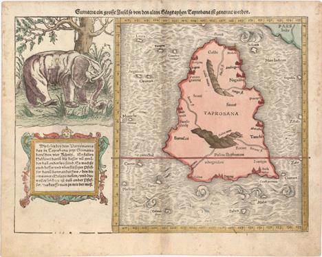
Sumatra ein Grosse Insel so von den Alten Geographen Taprobana ist Genennt Worden This is a great woodblock map of the island of Taprobana, which was variously thought to be Ceylon (Sri Lanka) or Sumatra until late in the sixteenth century. This map depicts Ceylon with the typical misconceptions of Ptolemy showing a small part of India incorrectly in the northeast corner of the map. A most interesting feature of the map is the large engraving of an elephant beneath a tree that was copied from Gastaldi with descriptive text in a cartouche below. The elephant is shown with large padded feet and a scoop on the end of its trunk. An elaborate woodblock engraving with German text on verso. A nice impression on watermarked paper with attractive color, light toning along the centerfold, and marginal soiling. 9.9"" W x 13.6"" H Munster, Sebastian 1572

Ins. Ceilan quae Incolis Tenarisin Dicitur This exquisite, early map of Sri Lanka is shown with an unusual five-sided shape. North is oriented to the left by an elaborate compass rose. The map was beautifully engraved by Petrus Plancius with pictorial detail of mountains, roads, forests, villages, kingdoms, mines, stupas and spice plantations. It is embellished with three strapwork cartouches and further adorned with a finely rendered sailing ship and animals roaming the interior (including a large elephant with his manhout). Latin text on verso. An attractive example with a professionally repaired centerfold separation that enters 1"" into map at bottom. 13.5"" W x 19.5"" H Mercator/Hondius, 1623

Insula Zeilan, olim Taprobana Nunc Incolis Tenarisim Superb map of Ceylon oriented with north to the left with two compass roses and rhumb lines. The island is well delineated with mountains, forests, roads, cities, forts, and temples. The map is richly embellished with sailing ships, a sea monster and two fine cartouches. The title cartouche at top is flanked by the allegorical female representation for Asia and a native holding elephant ivory. The scale of miles cartouche at bottom is surrounded by a group of adorable putti. Blank verso, published between 1650-57. A nice impression on paper with an elephant watermark. There are a few short tears, separations, and abrasions along the centerfold that have been archivally repaired. 16.3"" W x 20"" H Jansson, Jan 1657

An Accurate Map of the East Indies, from the Latest Improvements and Regulated by Astronomical Observations This decorative small map, with a rococo-style title cartouche and compass rose, extends from Persia to Indochina and south to include most of Sumatra and the corner of Borneo. It provides a good depiction of the Maldives, Ceylon, and the islands in the Indian Ocean with several of the smaller islands named. At the top of the map is the Coby or Sandy Desert, north of the Kingdom of Tibet. Engraved by R. Reynolds. A nice impression with a few miniscule pinholes only visible when held to light. 7.8"" W x 11.5"" H 1773

Bengala Charming miniature map of the northern part of the Bay of Bengal, which includes parts of northeastern India, Bangladesh and Burma. Locates and names numerous towns, with rocks and shoals noted offshore. Nicely engraved map featuring a strapwork-style cartouche and a sea monster. French text on verso. A fine impression with minor toning. 3.8"" W x 5.3"" H Hondius/Bertius, 1618

Affrica mit Seinen Befundern Landern/ Theiren/ und Wunderbarlichen Dingen This small woodblock map of the continent excludes the Horn of Africa and the Cape of Good Hope. It concentrates on the many kingdoms of Central and North Africa and depicts the Nile`s origins in twin lakes located near the Motes Lunae. On the recto is an image of cannibalism, with a man roasting on a spit. On a full sheet of German text measuring 7.8 x 11.7"".See also lot 774 for Norwich`s excellent reference work, which describes this map. There is marginal soiling, a worm track away from image at bottom right, and a tear that extends 1"" into image at bottom that has been partially repaired on verso with archival material. 5"" W x 6.3"" H Munster, Sebastian 1572

Africae Accurata Tabula This beautiful map of the African continent is typical of the late seventeenth century, including updated information taken from Blaeu`s wall map of the continent. The Cuama and Spirito Santo Rivers are shown with a common source in the Sacaf Lacus in South Africa. The Nile arises from the two lakes of Zaire and Zafflan, located below the Equator, as according to Ptolemy The interior is decorated with elephants, ostriches, monkeys, lions and rhinoceros, and eleven small ships sail in the sea. The title cartouche is flanked by natives and angels, and in the lower left is a dedication cartouche with the coat of arms of Gerardo Schaep surrounded by Neptune and his entourage. This is the second state of the map with the notation of privilege in the bottom.See also lot 774 for Norwich`s excellent reference work, which describes this map. A nice impression with a couple of minute holes along the centerfold and an expertly repaired centerfold separation that enters 4"" into map at bottom. 17.2"" W x 21.5"" H Visscher, Nicolas 1677

Afrique This striking map of Africa shows political divisions, towns and cities, rivers, lakes, mountains, deserts, and more. A large section in the interior surrounding the equator is largely blank. Madagascar appears in fine detail, and the smaller island groups in the Atlantic and Indian oceans are located as well. A key at bottom left explains the color-coding system that delineates the holdings of the various colonial powers on the continent. Printed by Louis Antoine and engraved by Smith and Gerin. Original color with minor offsetting. There is a centerfold separation in the bottom blank margin and toning along the sheet`s edges. 18.4"" W x 24.6"" H Andriveau-Goujon, E. 1876

Barbariae et Biledulgerid, Nova Descriptio Handsome map of the famed Barbary coast based on Gastaldi`s Africa. The map extends from Morocco to Libya and the western Mediterranean showing the proximity of the Balearic Islands, Corsica, Sardinia, southern Italy and Sicily. Richly engraved with place names, mountains, and numerous spurious lakes in the Sahara Desert. The title is contained in a strapwork panel across the top. Two fantastic sea monsters and a sailing ship ornament the map. Dutch text on verso with page number 53, published between 1571-73. Original color on watermarked paper with damp stains in blank margins, entering map border in a few areas. 13"" W x 19.9"" H Ortelius, Abraham 1571

Tab. III. Africae, in qua Cyrenaica, Marmarica, ac Lybia Exterior... Great Ptolemaic map of eastern Libya and Egypt with numerous ancient place names, particularly along the course of the Nile. The interior is filled with fanciful animals and monsters including a superb dragon. Mercator originally published this map in his 1578 edition of Ptolemy`s great Geography. Although he is most renowned today for the projection he popularized and for first using the term Atlas for a collection of maps, he devoted much of his life to his Ptolemaic maps. The maps were beautifully engraved as nearly as possible to their original form and embellished with fine cartouches. A nice impression with minor soiling and centerfold separations in top and bottom margins that have been archivally repaired. 13.3"" W x 18.6"" H Ptolemy/Mercator, 1730
![[Lot of 3] Egypt, and Arabia Petraea [and] Northern Africa [and] Western Africa A. Egypt, and Arabia Petraea, (9.9 x 13.6&qu](http://lot-images.atgmedia.com/SR/36385/2916721/684-201411614513_468x382.jpg)
[Lot of 3] Egypt, and Arabia Petraea [and] Northern Africa [and] Western Africa A. Egypt, and Arabia Petraea, (9.9 x 13.6""). This beautiful map is surrounded in a fine illustrated border incorporating Egyptian monuments and vignettes of the Mosque of Sultan Hassan in Cairo, Alexandria, the ruins of the Karnak Temple Complex, and the Great Sphinx of Giza. It is further embellished with a fleet of fishing boats in the Red Sea. The map itself provides incredible detail including road and caravan routes. The illustrations were drawn by J. Marchant and engraved by J.B. Allen; the map was drawn and engraved by J. Rapkin.B. Northern Africa, (13.0 x 10.0""). This lovely steel engraved map features a decorative border and vignettes of Mogador (now called Essaouira), Morocco, Constantine, Algiers, and Tunis. Many caravan routes are shown in the Sahara Desert, north of which is noted as Country abounding in Dates. The maritime states of Tunis, Algiers, and Morocco comprise the region known during this period as the Barbary Coast. The illustrations were drawn by H. Winkles and engraved by G. Greatbach; the map was drawn and engraved by J. Rapkin. C. Western Africa, (13.5 x 9.8""). This decorative map extending from Senegal to the Bight of Biafra is filled with detail and surrounded in a delicate border. Finely engraved vignettes include Fort Christiansborg, Cape Coast Castle, Sierra Leone, and Bakel. These vignettes were drawn by H. Winkles and engraved by E. Radclyffe; the map was drawn and engraved by J. Rapkin. Each map features original outline color, a couple minor spots in the images, and some toning and soiling mostly confined to the blank margins. See description Tallis, John 1850

Carte de la Barbarie de la Nigritie et de la Guinee Deftly engraved 18th century map of western Africa from Barbary, Nigeria, and Guinea to below the equator. There is a mass of geographic detail and notations in the interior with information on the rivers and lakes. Numerous tent encampments are depicted throughout the Sahara Desert. A note at the eastern end of the Niger River explains that some believe that the Niger is an ""arm of the Nile."" This map first appeared in Delisle`s Atlas de Geographie (1700-1712) and was here re-issued by Covens & Mortier, with their imprint below the title.See also lot 774 for Norwich`s excellent reference work, which describes this map. A fine impression with original color and a few insignificant spots. 19.5"" W x 24"" H Delisle/Covens & Mortier, 1730

Aegyptus Woodblock map of the Nile delta graphically depicting the sea, river, pyramids and sand dunes. On recto are two woodblock illustrations of stone sculptures. On a full sheet of German text measuring 7.8 x 11.7"". A slightly uneven impression with marginal soiling and a chip at bottom right of the sheet. 6.9"" W x 6.4"" H Munster, Sebastian 1572

Carte de l`Egypte de la Nubie de l`Abissinie &c. This very detailed and fascinating map of northeastern Africa, the Red Sea and the Arabian peninsula shows the political divisions and kingdoms, roads, topography, settlements, encampments and much more. The Nile originates in the mountains near the L. de Dambee. The map is filled with notations concerning the various tribes, trade routes, and the location of emeralds.See also lot 774 for Norwich`s excellent reference work, which describes this map. A fine impression with original color and two minute worm holes, only visible when held to light. 19.5"" W x 22.8"" H Delisle/Covens & Mortier, 1730
![[Lot of 3] Egypten oder Misir [and] Karte des Arabischen Meerbusens oder des Rothen Meeres [and] Karte von dem Groessten The](http://lot-images.atgmedia.com/SR/36385/2916721/689-2014116145111_468x382.jpg)
[Lot of 3] Egypten oder Misir [and] Karte des Arabischen Meerbusens oder des Rothen Meeres [and] Karte von dem Groessten Theil des Landes Jemen Imame, Kaukeban &. &.... This lot includes three large maps that cover the region from Egypt south to Somalia as well as the western Arabian peninsula showing portions of Yemen and Saudi Arabia. The first two maps of Africa show very good detail along the Nile River and the coastline of the Red Sea and display the location of emerald mines, ancient ruins, and caravan routes. The map of Arabia shows excellent inland detail with very dense hachuring and is filled with place names. Each map is adorned by a decorative title cartouche and several distance scales. The maps are based upon DAnville, Niebuhr, Irwin and Wussin. A. Egypten oder Misir, dated 1787, black & white (16.1 x 26.1""). Condition: There are a few small rust stains and a light damp stain along the upper left border. (B+)B. Karte des Arabischen Meerbusens oder des Rothen Meeres, dated 1787, hand color (18.7 x 26.5""). Condition: Scattered foxing. (B) C. Karte von dem Groessten Theil des Landes Jemen Imame, Kaukeban &. &. Nach Astronomischen Beobacht Ungen, und Reisemaassen, dated 1789, hand color (14.6 x 22.4""). Condition: A few minor spots in the image, else very good. (B+) Printed on heavy sheets with wide margins. See description for additional details. See description Schraembl, Franz Anton 1787-89

Guinea Elegantly engraved map covering the coast from Sierra Leone to Gabon. The land is filled with animals and the sea is decorated with ships and compass roses. The large title cartouche is flanked by two natives and topped by a very human-looking monkey. On the left of the title is a dedication cartouche to D. Nicolao Tulp, a famous Dutch doctor, and to the right two child-like sea creatures carry a large elephant tusk, representing the flourishing ivory trade. Dutch text on verso describes the region.See also lot 774 for Norwich`s excellent reference work, which describes this map. A nice impression with attractive color and wide margins. There is light printer`s ink residue, a few small spots in the image, and a light damp stain at bottom left, away from image. 15.1"" W x 20.7"" H Blaeu, Willem 1664
-
109182 item(s)/page