

Arabia (Tabula Asiae VI), Ruscelli, La Geografia di Claudio Tolomeo Allessadrino…, Venice, ca. 1574. 9.3 x 7”. (BW) This fine Ptolemaic map of the Arabian Peninsula, here called Arabia Foelix, is an enlargement of Gastaldi`s map of 1548. It is a fairly good representation of the peninsula, although Ptolemy overestimated the width of the southern part of the peninsula and distorted the shape of the Arabian Gulf. The map is presented on a trapezoidal projection with parallels and meridians (forerunners of lines of longitude and latitude) enumerated in the borders. Major towns are named, although not accurately located, and the rivers are entirely imaginary. Italian text on verso. Ref: cf Tibbetts no.30. A nice impression with printer`s ink residue and light toning along centerfold. There are a few small worm holes in blank margins that have been professionally infilled. (+B)
We found 109182 price guide item(s) matching your search
There are 109182 lots that match your search criteria. Subscribe now to get instant access to the full price guide service.
Click here to subscribe- List
- Grid
-
109182 item(s)/page

Basra, Iraq (Pays de Bassora, avec les Bourgs, Rivieres et Iles de sa Dependence, Habite par les Chretiens de S. Jean…), Aa, Atlas Nouveau, Leiden, ca. 1730. 14 x 11.1”. (HC) This charming map of southeastern Iraq depicts the junction of the Tigris and Euphrates Rivers. The important port city of Bassora (Basra) is depicted with a bird`s-eye plan showing the skyline and walled fortifications. The remaining countryside features scattered small towns and palm trees. The finely engraved title cartouche features shepherd and two river gods representing the Tigris and Euphrates. Published by Covens & Mortier. Printed on heavy, watermarked paper with original color. (+A)

Persia - Iran (Persia Sive Sophorum Regnum), Merian, Frankfurt, ca. 1650. 13.5 x 10.5”. (HC) This handsome map shows the Persian Empire during the time of the Safavid dynasty, based on Blaeu`s map of the region. It covers from the Caucasus to India, with the Persian Gulf coastline of the Arabian peninsula. There is good detail of hundreds of tiny villages. The emperor and two soldiers stand atop the title cartouche. Merian`s signature is at lower right. Watermarked paper with a professionally repaired centerfold separation that enters 1.5" into map at top. (A)

Central Asia (Tabula Asiae II), Munster, Basel, ca. 1545. 13 x 10.5”. (HC) Woodblock Ptolemaic map of ancient Sarmatia located northeast of the Black Sea. Mountain ranges dominate the map and three gates are shown in the Caucasus Mountains, which in ancient times used to be a caravan route to the ancient Orient. The Alexandri Columns are shown in present day Georgia. Latin text on verso. (A)

Asia (Asia wie es Jetziger Zeit nach den Furnemesten Herzschafften Abgetheilet und Beschriben ist), Munster/Petri, Cosmographia Universalis, Basel, ca. 1588. 14.2 x 12.5”. (HC) Handsome woodblock map based on Ortelius` 1570 map of Asia, which was the standard map of Asia for more than forty years. Petri added this map to Munster`s Cosmographia from 1588 onwards, probably in an effort to compete with Ortelius` great atlas. The cordiform projection shows Asia extended too far to the east, an error propagated with Ptolemy. Japan is in a `kite` form taken from Jesuit sources. Luzon is absent from the Philippines, and there are a great number of islands in the East Indies, but they are not well placed, due to the secrecy of voyages to the region. A portion of New Guinea is located in the lower right. The title is in the top margin and a text box describes the region. German text and illustration on verso. Ref: Yeo no.9. Light toning with a few faint spots. (+B)

Asia (Asia with the Islands Adioyning Described, the Atire of the People, & Townes of Importance, All of them Newly Augmented), Speed, A Prospect of the Most Famous Parts of the World, London, 1626. 20.5 x 15.8”. (HC) This beautiful carte-a-figures map is the first English printed map of Asia. It is flanked by costumed figures of Asian peoples with a series of eight city views forming a decorative frieze across the top including Damascus, Jerusalem, Aden, Hormus, Goa, Kandy, Banten and Macau. The map is based largely on Jodocus Hondius` map of 1623 with detailed depictions of the East Indies, the Philippines and the elongated peninsula form of Korea. Large lakes and rivers dominate the interior of China and the mythical Lake of Ciamay spawns five large rivers in India Without Ganges. The Great Wall of China is placed too far north. The Caspian Sea is greatly enlarged and oriented in an east-west direction. The map is further embellished with a title cartouche, numerous sea creatures and sailing ships and an elephant appears in the interior of China. Beautifully engraved by Abraham Goos with the imprint of Bassett and Chiswell, published circa 1676. The English text on verso provides a fascinating Anglo-centric view of Asia. Ref: Yeo no.30; Shirley (BL Atlases) no.T.SPE-2a-2; Moreland & Bannister, p. 148-50. Expert paper repairs and light toning all confined to the blank margins. (A)

Asia (Asia Noviter Delineata), Blaeu, Amsterdam, ca. 1670. 22 x 16.3”. (HC) This is one of the most famous 17th century maps of the continent of Asia. It is surrounded in a beautiful carte-a-figures border and is richly ornamented with animals, sea monsters and sailing ships. The eastern coastline of Asia is severely truncated, Korea is shown as an island, and Japan is depicted on the Ortelius-Teixeira model. The Indian subcontinent is too narrow and the islands of Indonesia are very sketchy. A large island labeled Ceiram probably represents the western part of New Guinea. In the interior, the Caspian Sea is oriented on an east-west axis and there are several large erroneous lakes in China including the mythical Chiamay Lacus. The frieze across the top features vignettes of the cities of Candy, Calecut, Goa, Damascus, Jerusalem, Hormuz, Banten, Aden and Macao. The inclusion of Banten reflects the emergence of the Dutch as a major commercial power in the East Indies. The side panels flanking the map depict costumed figures of the various Asian peoples. This is a later edition with evidence of a crack in the copperplate at bottom center. Latin text on verso. Ref: Walter no.25; Yeo no.24. Lovely old color with a few printer`s creases. There is a tiny 1/8" tear near the "C" in China. (+B)

Asia (Asiae Status Naturalis Dextera Dei Omnipotentis Perfect Geographice Designat), Scherer, Atlas Novus, Munich, 1700. 14 x 9”. (HC) This interesting map appeared in one of the earliest thematic atlases and shows the distribution and types of fauna in Asia. The stunning cartouche features an elephant, lion, camel, monkeys and exotic birds. Monstrous fish adorn the oceans, and various animals are scattered across the continent. Geographically the map is very imaginative with a bulbous Iedso (Hokkaido) attached to Honshu by a narrow isthmus, and Compagnie Land and Staten Eyland to the north of Hokkaido. Nova Zemba is shown as an island; whereas early cartographers typically depicted only the southern and western coastlines reflecting the discoveries of Barents and Linschoten. The Caspian Sea is depicted with a curious oval shape, and the mythical Lac Chiamay is shown with its five south-flowing rivers. In Southeast Asia Terra dos Papous is separated form New Guinea, I. Celebes (Sulawesi) is far too close to Borneo, and a portion of Australia (Nova Hollandia) is depicted. Ref: Yeo no.94. Faint offsetting and a professionally repaired centerfold separation. (A)

Asia (Asiae Recentissima Delineatio, Qua Status et Imperia Totius Orientis, unacum Orientalibus Indiis…), Homann, Nuremberg, ca. 1712. 23 x 19”. (HC) This is a bold and very decorative map of Asia with a particularly interesting depiction of Japan. Hokkaido and Honshu (Terra Yedso) are joined together by a narrow isthmus and separated from the mainland by a wide strait. An accompanying note acknowledges Scherer as the source, although the orientation of Yedso and Companies Land appears to be based on the Delisle model. A huge lake appears in Tibet and is named the legendary Chiamay. A second lake is shown in the position usually occupied by Lake Chiamay, but here it is named L. Cananor Cunabete. In Southeast Asia the straits between New Guinea and Australia appear in a tentative fashion, noting Dampier`s Strait and a disembodied Carpentaria with no definite northern limit. This is an early edition with two elaborate cartouches. The lower title cartouche features an Asian queen holding court, the upper cartouche a ceremonial procession. Ref: Yeo no.109. The upper centerfold has been reinforced on verso with archival tape and a few tears in the lower blank margin have been repaired on verso, also with archival tape. (A)

Asia (A New Map of Asia from the Latest Observations…), Senex, London, ca. 1714. 22.3 x 19”. (HC) This handsome map of Asia extends to include northeastern Africa and the northern tip of Australia. The map is based on Schenk`s 1708 edition of Guillaume Delisle`s map of Asia, with the exception of Japan, as it is not connected to Land of Iesso as in Delisle`s map. A note next to Iesso states that "the land and seas between Japon, Corea and Iesso are hitherto undiscovered and it is not known whether Iesso be a part of the continent or not." A Sandy Desert is depicted in Mongolia, and the route of Isbrand Ides (Isbon Idres) expedition through Asia is marked. The northern coastline, which is noted as ye Supposed N. Coast, is shown in an inset at bottom. Ref: Yeo no.110. Original outline color on watermarked paper with marginal soiling and some professional paper repairs in blank margins. (A)

Asia (A New Map of Asia, Divided into its Empires and Kingdoms, with all the European Settlements in the East Indies…), Sayer, London, ca. 1757. 37.5 x 22.5”. (HC) This uncommon, large map of Asia extends west to the eastern Mediterranean and the Red Sea. Sayer gives credit to D`Anville and Robert de Vaugondy for the improvements in cartography. The Korean peninsula is truncated, and Japan with Land of Yezo (Hokkaido) are too large. In the northeast corner are two fictitious islands, Company`s Land and Land seen by Juan de Gama, which were supposedly discovered by Jean de Gama. Vitus Bering finally debunked the myth of the islands in his explorations of the area in 1729, but the islands remained on maps for almost 50 years until Cook confirmed Bering`s reports. The direction of the trade winds is shown in the seas. Insets of the Dardanelles, the Gulf of Smyrna (Izmir), Bombay (Mumbai), and the Hooghly River detail important centers in the British Empires’ quest to dominate trade with Asia. A detailed table at bottom left outlines the divisions within Asia by the Eight Principal Parts and the European Settlements. The map is adorned with a compass rose and an elaborate title cartouche surrounded by images of the Orient. Printed on two sheets, joined as issued. Old color and wide margins with light toning along centerfold, a few minor creases, and one tiny hole. A few short tears in blank margins, and one that enters 2" into map image at right, have been professionally closed on verso with Japanese tissue. (+B)

Asia (Asie Divisee en ses Principaux Etats, Empires & Royaumes), Robert de Vaugondy/Delamarche, Paris, ca. 1805. 26 x 19.8”. (HC) A comprehensive view of Asia from Turkey and the Middle East to the Bering Strait and New Guinea in the east. Detailed depiction of Russia and the Russian and Chinese Tartaries, with their tribes marked. Tibet is labeled Etat du Dalai Lama. The map incorporates La Perouse`s discoveries north of Japan and to incorporate part of Northern Australia and the Torres Strait. Originally by the Robert de Vaugondy family, this map was reissued by their successor, Charles Francois Delamarche. The map is based on the work of the Robert de Vaugondy family, but was re-engraved by Delamarche to incorporate the latest information gathered by the explorations noted. A table with geographical and statistical information on the region in included at right. Original outline color on watermarked paper, with an archivally repaired centerfold separation that enters 5" into image at bottom, and an unrepaired 3/4" tear adjacent to centerfold near Siam. There are some small worm tracks primarily confined to blank margins that have been professionally repaired, with a minor amount of border in facsimile. (B)

Asia (Asia), Lucas, A General Atlas…, Baltimore, ca. 1823. 8.5 x 10.3”. (HC) A detailed map of Asia locating many cities, rivers, mountains and deserts. In the north, Novaya Zemlya is not fully delineated. In the south, the coast of Australia is depicted, along with a partially outlined New Guinea. Australia is labeled both New Holland and New South Wales, but with New South Wales incorrectly located on the northwest coast. Lucas` General Atlas is known as one of the finest general atlases produced in the U.S. at the time, due to the high quality paper, superior engraving quality, and attractive coloring style. Light toning with a few faint spots and light offsetting in blank margins. (+B)

Asia (Asie), Levasseur, Atlas Universel Illustre, Paris, ca. 1845. 17.5 x 11.3”. (HC) This decorative map of the Asian continent is surrounded by steel engraved vignettes depicting the various peoples of Asia in costume, several exotic animals, and a seated portrait of Adam and Eve. The map graphically depicts the Great Wall of China, and extends to include Sumatra and Borneo. Iran is Perse, Thailand is Siam and Sri Lanka is Ceylan. There is an interesting population chart at right totaling only 638,550,000 for the entire continent. The illustrations were drawn by Raimond Bonheur, father of the famous painter Rosa Bonheur, who trained under her father. A couple of small, unobtrusive spots. (A)

Asia (Asia), Tallis, London, ca. 1851. 12.8 x 9.8”. (HC) Finely engraved map of Asia that extends from Turkey through China and Russia to show a little of Alaska, and from the Arctic Ocean south to delineate all of the East Indies. Beautifully engraved and rendered vignettes of Petra, Tartars, Russian Peasants, The Walrus, and Sun-Birds of India and the Philippine Isles. The map is surrounded by a decorative border. Delicate original hand coloring in outline with a hint of toning. The decorative border and vignettes are uncolored as issued. (A)

Northern Asia (Tartaria sive Magni Chami Imperium), Blaeu, Amsterdam, ca. 1635. 19.5 x 15”. (HC) This great map of Tartaria covers all of eastern Asia between the Caspian Sea and northern China and Manchuria. Being one of the most remote regions of Asia, it was among the last to be properly explored and mapped. This map combines the knowledge obtained by the English and Dutch explorers as far as the Ob River with the balance of the map based on the reports of Marco Polo and the Greek classics. The deserts are filled with a wild assortment of devils and dragons, being held at bay from China by the Great Wall. Explorers flank the distance scale and the title is symbolically engraved onto the saddle blanket of a camel, representing the trade over the Silk Road. This map is nearly identical to Jansson`s map of the same title, but includes a scale across the top. French text on verso. Old color with wide margins, light toning and a centerfold separation confined to the upper blank margin. There are a few short tears in blank margins, far from image. An ownership label is adhered to the lower right corner, well away from the image. (+B)

Northern Asia (Tabula Tartariae et majoris partis Regni Chinae), Wit, Amsterdam, ca. 1685. 21.5 x 17.2”. (HC) Fine map of the region from the Caspian Sea through China and Japan. Eastern Russia is truncated with no Kamchatka peninsula and Yedso is shown according to the voyages of De Vries. The Great Wall is prominently shown separating China from the interior deserts. The mythical Chiammay Lacus is shown with its five major rivers. A strapwork title cartouche with two putti and a compass rose ornament the chart. There are professional repairs of a few centerfold separations and tears along centerfold, as well as tears and chips in blank margins. Light toning along centerfold and discoloration in a few areas due to cello tape used to repair tears, which has since been removed. Manuscript page number in upper right corner. (+B)

Northern Asia (Charte das Russische Reich und die von den Tatarn Bewohnte Lander in Europa und Asia Enthaltend…), Gussefeld/Homann Heirs, Nuremberg, 1786. 23.5 x 18”. (HC) This expansive map of the Russian Empire extends to show China, Korea (Corea), and Japan and delineates the Great Wall. The lovely cartouche features a three-masted ship. A scroll-like inset lists names of 24 regions keyed to the map. French title above top border, "Carte de l`Empire de Russie & de la Grande Tatarie…" The centerfold has been reinforced and there is some minor surface soil in the margins. (+B)

Russian Empire (The Russian Empire, in Europe & Asia, with the Northern Discoveries between Asia & North America), Bowen, Bankes`s New System of Universal Geography, London, ca. 1785. 17.8 x 12.5”. (BW) This uncommon map covers the whole of the Russian Empire but emphasizes the Asian regions. Particular attention is focused on the recent discoveries in the Bering Sea (here labeled Sea of Kamtschatka). An island archipelago appears off Kamtschatka that is likely part of the Aleutian Islands, but they are placed too close to the Asian continent. Novaya Zemlya is shown as a single large island. There is a tear in the lower portion of the map that extends one-inch past the neatline but is primarily confined to the blank space. There is a surface tear at lower left corner just inside the neatline but it does not go completely through the paper. (B)

China (Chinae, olim Sinarum Regionis, Nova Descriptio. Auctore Ludovico Georgio), Ortelius, Theatrum Orbis Terrarum, Antwerp, 1584. 18.8 x 14.5”. (HC) This landmark map provides a fascinating view of the mysterious orient from a Renaissance perspective. Ortelius based the map on the work of Jorge de Barbuda, a Portuguese Jesuit also known as Ludovicus Georgius, whose manuscript map reached Ortelius by way of Arias Montanus. The depiction, which became the standard image of China for over half a century, shows the legendary kingdom at an early point in European exploration of the region. The map is oriented with north to the right and extends into parts of Indo-China, the Philippines and part of Japan. The Great Wall is prominently delineated and several huge lakes and rivers dominate the topography. Illustrations in the interior include tent cities of the Tartars, stags, elephants and elaborate sail-powered carriages. The map is further adorned with three ornamental cartouches. Second state with las Philippinas added above Sinus Magnus, published in the Latin edition of 1603. Ref: Walter no.11F; Van den Broecke no.164. Watermarked paper with a tiny hole along centerfold towards bottom, an archivally repaired centerfold separation that just enters map border at bottom, and one tiny tear in bottom blank margin. (A)

China (China Regio Asie), Ortelius/Galle, L`Epitome du Theatre, Antwerp, ca. 1595. 4 x 3”. (HC) This is the miniature version of Ortelius` important map focusing on China. The map is oriented with north to the right and extends to include parts of Indo-China. The Great Wall is prominently delineated and several huge lakes and rivers dominate the interior. A portion of Japan appears at bottom center. French text on verso. Ref: King (2nd ed.) pp. 64-65. Watermarked paper with light toning and a small worm track in right blank margin, far from map image. (+B)

China (Regni Sinae vel Sinae Propriae Mappa et Descriptio Geographica…), Haas/Homann Heirs, ca. 1750. 20.5 x 23”. (HC) This excellent and highly detailed map of China is based on the works of Du Halde and D`Anville. The map extends from the Gobi Desert in the north to Hainan Island in the south and includes Tai Ouan vel Ins. Formosa (Taiwan). Decorative cartouches at the bottom feature dragons and a phoenix. Light toning along centerfold with a few spots and faint damp stains. Trimmed close to the neatline at lower left. (+B)

China (China and Birmah), Tallis, The Illustrated Atlas, London, ca. 1850. 13 x 10”. (HC) A most decorative and detailed map of the region, which also names many locations on Taiwan (Formosa). The very attractive steel engraved vignettes include British Factories - Canton, Hong Kong, a pagoda, Chinese Soldiers, and two showing native costumes. It is further embellished with a decorative border and title included in a cartouche at top center of the border. Original outline color with a hint of edge toning and marginal soiling away from the map image. (A)

Northern China (Xensi, Imperii Sinarum Provincia Tertia), Blaeu, Amsterdam, ca. 1655. 19 x 15.8”. (HC) Based on the remarkably accurate compilations of the Jesuit Father Martino Martini during his travels between 1643 and 1650, this map of the Xensi (Shaanxi) province features the Great Wall of China. A legend at left illustrates towns of various sizes, forts, and the locations of gold mines. The map is adorned with two decorative strapwork cartouches. Lovely color and wide margins with a small hole near centerfold caused by a paper flaw and scattered foxing. (+B)

Eastern China (Huquang, Imperii Sinarum Provincia Septima), Blaeu, Amsterdam, ca. 1655. 19.3 x 16”. (HC) Based on the remarkably accurate compilations of the Jesuit Father Martino Martini during his travels between 1643 and 1650, this map of the Hubei province is centered on the Yangtze River, Kiang Flu Pars. A legend at bottom left illustrates towns of various sizes, forts, and the locations of silver mines. The city of Vuchang (Wuhan) is located along the river. A strapwork title cartouche incorporates the scale of miles and is flanked by two rice farmers. Lovely color and wide margins with uneven toning and light offsetting. (+B)

China, Korea & Japan (The Kingdome of China Newly Augmented), Speed, A Prospect of the Most Famous Parts of the World, London, 1626. 20.3 x 15.5”. (HC) This superb map of China, Korea and Japan is the only carte-a-figures map made of the region. The Great Wall protects the Kingdom of China from a variety of evil creatures that occupy The Desert Lop, and the rest of the kingdom is delineated by a long range of mountains in the west that separates it from The Kingdome of Bramas. Korea is a long island and Japan is presented on the Ortelius-Teixeira model. The decorative panel at top features bird`s-eye plans of Macao (copied from DeBry) and Qyinzay (Hangzhou) along with scenes depicting ingeniously crafted wind-carts and their manner of execution (crucifixion). The inhabitants of the region are shown at sides, including a very early depiction of a Japanese soldier. There are interesting notes throughout the map on various historical and mythical aspects of the region, including where men are seduced by wonderful illusions and where fireproof cloth is woven. The English text on verso provides an equally fascinating description of Chinese culture. George Humble`s imprint at Popshead Alley is at lower right. Ref: Cortazzi, plt. 29; Manasek no.56; Shirley (BL Atlases) T.SPE-2a no.19. A slightly uneven impression with show-through of text on verso and a few tiny holes caused by imperfections in the paper. There is an expertly repaired long tear adjacent to Lake of Chiamay and a couple of small holes with loss of image. There are other professional repairs to tears and chips in blank margins, one of which enters 1/2" into image at bottom left with a small amount of border in facsimile. (B)

China, Korea & Japan (China Veteribus Sinarum Regio nunc Incolis Tame dicta), Jansson, Amsterdam, ca. 1636. 19.5 x 16.3”. (HC) Several large lakes dominate the topography of this elegantly engraved map of China. The Great Wall forms the northern boundary of China. The fictitious Chiamay Lacus is shown with numerous rivers flowing south into India and Siam. Korea is depicted as a strangely shaped island separated from the mainland by a narrow strait. Taiwan is located in a roughly correct position, named as both Pakan al I. Formosaand Tayoan The three main islands of Japan are shown on the Ortelius/Teixeira model. The map is richly embellished with European sailing ships and Chinese sampans, a decorative distance scale, and a title cartouche flanked by a Chinese man and woman. German text on verso. Clean, wide margins with light show-through of text on verso. There is a small, professionally repaired hole in bottom left blank margin and a tiny hole in top blank margin. (A)
![China, Korea & Japan (Imperii Sinarum Nova Descriptio), Cluver, Introductio in Universam Geographicam…, [1697]. 10.](http://lot-images.atgmedia.com/SR/36385/2862480/764-201251017557_468x382.jpg)
China, Korea & Japan (Imperii Sinarum Nova Descriptio), Cluver, Introductio in Universam Geographicam…, [1697]. 10.3 x 8”. (HC) Handsome small map based on the important Martini/Blaeu map of the Chinese Empire. It shows a fair number of provinces and cities named in the interior. The Great Wall is depicted along the northern border. A large fictitious interior lake labeled Kia Lacus is the source of five large, southern rivers. The map extends to include Formosa, Korea and parts of Japan and Laos. The title cartouche depicts a Jesuit with a Chinese nobleman and warrior and a large incense pot. There is some very faint offsetting in the image, else fine. (A)

China, Korea & Japan (Chinese Empire, and Japan), Philip, London, ca. 1900. 24 x 19.8”. (PC) This pocket map shows the region in excellent detail. Railways, submarine cables and treaty ports are specifically called out. The Great Wall is shown. The map is mounted on linen and folds into brown covers (4.5 x 6.5") with large paper label "Philip`s Authentic Map of China Mounted on Cloth." Inside cover shows an advertisement for the full series of "Shilling Maps" by Philips. There are a few spots and tiny worm holes in the image, as well as worm tracks in the left blank margin. Covers are worn and lightly stained, and the spine is cracked in the interior. (+B)

Japan & Korea (Iaponiae Insulae Descriptio), Ortelius, Theatrum Orbis Terrarum, Antwerp, 1595. 19 x 14”. (HC) This landmark map was the first map of Japan published in a European atlas. Ortelius received the map from Ludovico Teixeira, a Portuguese Jesuit cartographer and mathematician. While Teixeira had not personally traveled to Japan, he obviously had access to Japanese sources as the map presents the first reasonably accurate and recognizable depiction of the island nation with numerous Japanese place names. Korea appears as an island tapering to a point labeled Punta dos ladrones. The map is elegantly embellished with three large galleons, two elaborate cartouches and a boldly engraved border. This influential map was to become the basis for many other cartographers` maps of Japan for more than fifty years. This is the first state with Latin text on verso, published between 1595-1609. Ref: Walter OAG no.5, plt. 19; Van den Broecke no.165. Insignificant soiling in wide, blank margins and a minute pinhole near Hizu only visible when held to light. (A)

Japan & Korea (Corea and Japan), Thomson, New General Atlas, Edinburgh, 1815. 24.5 x 19.5”. (HC) A lovely map of Japan and Korea showing the discoveries of Broughton and Krusenstern who traveled in the region in 1796-97 and 1805-11, respectively. In Japan, Kyrushu, Shikoku, and Awajishima are significantly more correct than earlier maps. Nicely detailed with regions delineated, it shows towns, roads, rivers, lakes and mountains. Ref: Walter no.128. Original color with faint offsetting and light toning along centerfold. There is some minor creasing in top blank margin. (+B)
![Japan (Iaponia), Mercator/Hondius, Atlas sive Cosmographicae, Amsterdam, [1613]. 17.5 x 13.3”. (HC) Superb map of Japan](http://lot-images.atgmedia.com/SR/36385/2862480/771-201251017638_468x382.jpg)
Japan (Iaponia), Mercator/Hondius, Atlas sive Cosmographicae, Amsterdam, [1613]. 17.5 x 13.3”. (HC) Superb map of Japan based on the Ortelius/Teixeira model with Honshu, Kyushu, and Shikoku depicted with approximately the correct proportions. Korea is shown as an island, although Hondius added a notation to the effect that is was uncertain if the region was an island or a peninsula. The map is richly ornamented with two strapwork cartouches, a European and Japanese ship, and a sea monster. Hondius engraved this map for inclusion in his edition of Mercator`s atlas after he acquired Mercator`s plates. It appeared in the editions of Atlas Sive Cosmographia from 1606 to 1636. Latin text on verso. Ref: Walter (OAG) no.22. Original color and wide margins with a small printer`s crease adjacent to centerfold. There are some small areas of paper loss in the blank margins that has been closed with tissue on verso. (+B)

Japan (Johnson`s Japan Nippon, Kiusiu, Sikok, Yesso and the Japanese Kuriles), Johnson & Ward, New York, ca. 1865. 15.3 x 13”. (HC) An attractive map with insets of Yesso and the Japanese Kuriles, and the Bay of Nagasaki. The map was compiled from the maps of Siebold and the surveys of the U.S. expedition to Japan in 1841. English translations of Japanese terms used on the map are included in a key at bottom. Lightly toned with a couple of insignificant spots and faint damp stains in bottom blank margin. There are binding holes in top blank margin that do not affect map image. (+B)
![Tokyo, Japan ([Japanese Map of Tokyo]), Anon., ca. 1890. 20.3 x 28.5”. (HC) This impressive and highly detailed map of](http://lot-images.atgmedia.com/SR/36385/2862480/775-201251017652_468x382.jpg)
Tokyo, Japan ([Japanese Map of Tokyo]), Anon., ca. 1890. 20.3 x 28.5”. (HC) This impressive and highly detailed map of Tokyo displays roads, docks and waterways. It is surrounded by 33 scenes of important buildings and places around the Imperial city. Includes an inset and numerous tables. Japanese maps from the Meiji period incorporate western cartographic elements, such as the large compass rose, into the traditional Japanese cartographic style. The map was produced for the Japanese market with names and descriptions in Japanese characters. There are a few fold separations, a number of small wormholes in the image, and bleed-through of color on verso. Missing its protective covers. (B)

Southeast Asia (Indiae Orientalis, Insularumque Adiacientium Typus), Ortelius, Theatrum Orbis Terrarum, Antwerp, ca. 1570. 19.5 x 13.8”. (HC) Ortelius` important map of Southeast Asia, based on Mercator`s 1569 World map, shows how sketchy the available information was concerning the region. The East Indies are presented as a randomly scattered archipelago with Java and Borneo particularly misshapen. Taiwan is mapped for the first time as I. Fermosa in the `tail` of kite-shaped Japan`s Lequaio islands. The fictitious Chyamai lacus is the source of a network of major rivers in Southeast Asia. Beach pars, a presumed promontory of the great southern continent based on Marco Polo`s account, protrudes into the bottom of the map. In the upper right corner, America makes an appearance with the three coastal cities of Quivira, Cicuie, and Tiguex. Near the shore lies a ship being menaced by a pair of sea monsters, while twin mermaids preen before each other near the Ladrone Islands. Latin text on verso, published between 1570-73. Ref: Van den Broecke, no.166; Suarez, pp 164-69. Lovely old color on watermarked paper with minor soiling and a professionally repaired centerfold separation that enters 1" into map at bottom. There is a tear in bottom blank margin that has been closed on verso with archival tape, and a chip at the upper right corner in the blank margin has been replaced with old paper. (+B)
![Southeast Asia (Asiae XI Tab), Ptolemy/Mercator, Theatrum Geographiae Veteris…, Leiden, [1618]. 13 x 13.5”. (BW)](http://lot-images.atgmedia.com/SR/36385/2862480/778-20125101773_468x382.jpg)
Southeast Asia (Asiae XI Tab), Ptolemy/Mercator, Theatrum Geographiae Veteris…, Leiden, [1618]. 13 x 13.5”. (BW) Fine Ptolemaic map of the region of Thailand and Malaysia. The map shows an oddly shaped peninsula to the east of the Ganges and the Sinus Magnus (South China Sea), with a landmass to the east of that. This depiction is the legacy of Ptolemy`s idea of a landlocked Indian Ocean. Although he is most renowned today for the projection he popularized and for first using the term Atlas for a collection of maps, Mercator devoted much of his life to his Ptolemaic maps. The maps were beautifully engraved as nearly as possible to their original form and embellished with fine cartouches and cultural scenes. This map includes a caravan, camels, ships and boats. Ref: Mickwitz & Miekkavaara (Nordenskiold) no.232-27. There are two tiny holes near the centerfold, light damp staining and some scattered foxing primarily in the blank margins. Right margin is trimmed close to the neatline. (B)

Southeast Asia (Indiae Orientalis Nova Descriptio), Jansson, Amsterdam, ca. 1633. 20 x 15.5”. (HC) Decorative chart of the region including Indochina, the Philippines and the East Indies. Includes the new discoveries in New Guinea made by the Dutch "Duyfkens" exploration. The map is embellished with rhumb lines, sailing ships, sea monsters, compass roses and three cartouches. The cartouches feature indigenous people, mermaids and a sea monster. German text on verso. Ref: Schilder Australia no.24; Clancy Map 6.6; Tooley 746; Phillips (A) 445 [674-75]. Minor soiling and light show-through of text on verso. (+B)

Southeast Asia (India quae Orientalis dicitur, et Insulae Adiacentes), Blaeu, Amsterdam, ca. 1635. 19.8 x 16.2”. (HC) This handsome chart of Southeast Asia includes one of the most detailed images of the sphere of operations of the trading empire of the Dutch East India Company. It extends from India to New Guinea and parts of northern Australia, and north to the southern coast of Japan with a portion of Korea, which is named as an island. This map was a vast improvement over Blaeu`s map of the Asian continent and was presented on Mercator`s projection in the style of navigational charts. Significantly, it delineates a more correct outline of New Guinea and is the first atlas map to include the discoveries made by the Dutch in the Gulf of Carpentaria -- thus the first recorded European contacts with Australia. Richly embellished with sailing ships, compass roses and three sumptuous cartouches. The cartouche at lower left features the coat of arms and dedication to Laurens Real, Governor General of the East Indies, 1616-18. French text on verso. Ref: Suarez (SEA) p. 201; MCC-60 Tooley (Australia) no.226. Attractive color with a few minor spots, professionally repaired centerfold separations, and marginal soiling. (+B)

Southeast Asia (Archipel des Indes Orientales, qui Comprend les Isles de la Sonde, Moluques et Philippines), Robert de Vaugondy, Atlas Universel, Paris, 1750. 23.5 x 19”. (HC) A detailed depiction of the region centered on Borneo, showing Sumatra, Java, the Malay Peninsula, the Philippines, and the tips of New Guinea and Northern Australia (Nouvelle Hollande). An inset at upper right depicts the Marianas. The map names Sincapoura (Singapore) and Batavia (Jakarta) and locates the important Spice Islands. A decorative rococo-style title cartouche and three distance scales are also featured. Engraved by Guillaume Delahaye. Ref: Pedley no.413. Wide margins and original outline color with an unobtrusive paper flaw in blank area of map image along bottom centerfold. (A)

Borneo, Sumatra, Java (Le Royaume de Siam avec les Royaumes qui luy sont Tributaires et les Isles de Sumatra Andemaon etc…), Chatelain, Atlas Historique…, Amsterdam, ca. 1719. 17 x 15”. (BW) This finely detailed and beautifully engraved map of South East Asia shows the Kingdom of Siam (Thailand), the Malaysian Peninsula and the islands of Borneo, Sumatra and Java. This was the domain of the Dutch East Indies Company (V.O.C.), which made its headquarters in Batavia (Jakarta) on the island of Java. Ship routes from Batavia to Siam are noted. The map is based on the Jaillot/Mortier map that was derived largely from the accounts of the French Jesuit mission to Siam in 1685-86. Nice impression on watermarked paper with wide original margins and mild toning along the centerfold. (+B)

Indonesia (Kaart der Zuyd-Wester Eylanden van Banda), Valentyn, Oud en Nieuw Oost-Indien, Amsterdam, ca. 1726. 21.5 x 17.5”. (BW) A fascinating map of the islands in the southwestern part of the Banda Sea including Sumba, Flores and Timor. Valentyn was an prominent historian of the Dutch East India Company (VOC) who is best known for Oud en Nieuw Oost Indien, which was published by Joannes van Braam and Gerard onder de Linden. He twice traveled to the East Indies and served as Calvinist minister to Ambon between 1686 and 1694. In preparing this monumental work, he was given privileged access to the previously secret archives of the VOC, containing transcripts and copies of important earlier Dutch voyages. Wide original margins with light offsetting and numerous tiny wormholes in unengraved areas of the map. There is a repaired tear that enters 1.5" into map at right. Issued folding. (B)
![Surabaya & Pasuruan, Java (Kaarte van de Vesting op Soerabaya [on sheet with] Kaarte van de Pagger Tot Passaroewan), Vale](http://lot-images.atgmedia.com/SR/36385/2862480/787-201251017739_468x382.jpg)
Surabaya & Pasuruan, Java (Kaarte van de Vesting op Soerabaya [on sheet with] Kaarte van de Pagger Tot Passaroewan), Valentyn, Oud en Nieuw Oost-Indiën, Amsterdam, ca. 1725. 7 x 12”. (HC) This sheet contains bird`s-eye plans of two fortresses in northeastern Java, with keys identifying various buildings and features. At top is a map of the fortress in Surabaya, as depicted by G. v. Broekhuysen on March 20, 1708. The lower map is of the fortress in Pasuruan, which was surrounded by coconut trees and a "wall made of earth." The plans to these important ports were used by the Dutch East India Company when they overtook control of the cities from the Sultanate of Mataram in November 1743. Surabaya later became a major trading center under the Dutch colonial government. Valentyn was a prominent historian of the Dutch East India Company who is best known for Oud en Nieuw Oost Indien, his vast illustrated account of the Dutch trading empire in Asia. He twice traveled to the East Indies and served as Calvinist minister to Ambon between 1686 and 1694. In preparing this monumental work, he was given privileged access to the previously secret archives of the VOC, containing transcripts and copies of important earlier Dutch voyages. Watermarked paper with a small wormhole in blank area of lower map, and another small one in key at bottom. (+B)
![India & Sri Lanka (Tabula Asiae X), Gastaldi, La Geografia, Venice, [1548]. 7 x 5.3”. (BW) Rare little Ptolemaic ma](http://lot-images.atgmedia.com/SR/36385/2862480/788-201251017741_468x382.jpg)
India & Sri Lanka (Tabula Asiae X), Gastaldi, La Geografia, Venice, [1548]. 7 x 5.3”. (BW) Rare little Ptolemaic map centered on India with recognizable river systems, but completely lacking the sub-continental shape of the landmass. The top of a large Taprobanae Pars (Sri Lanka) appears at bottom. The map is presented on a trapezoidal projection with rope-like mountain ranges and strange creatures in the border, one of them being a bird with the face of a man. Italian text on verso. Ref: Karrow no.30/53; Mickwitz & Miekkavaara (Nordenskiold) II no.214-49. Printer`s ink residue on the plate and light toning along centerfold. (+B)
![India ([Lot of 2] Presqu`Isle de l`Inde deca la Gange... [and] L`Empire du Grand Mogol), Sanson, Paris, ca. 1700. 9.5 x 7.5&#](http://lot-images.atgmedia.com/SR/36385/2862480/790-201251017755_468x382.jpg)
India ([Lot of 2] Presqu`Isle de l`Inde deca la Gange... [and] L`Empire du Grand Mogol), Sanson, Paris, ca. 1700. 9.5 x 7.5”. (HC) A. Presqu`Isle de l`Inde deca la Gange, ou sont les Royaumes, de Decan, de Golconde, de Bisnagar, et le Malabar. Striking map of southern India, with a portion of Sri Lanka shown as well as a bit of the Maldives. The Malabar Coast is depicted in an inset. The map is filled with details and place names, including the Coromandel Coast and Cape Comorin. Engraved by Antoine d` Winter. Condition: Watermarked paper with marginal soiling and binding holes in right blank margin. (A) B.L`Empire du Grand Mogol. This small map covers Northern India and present-day Nepal and Bangladesh and shows the political divisions, topography, cities and major towns. At right is the mythical Lac de Chiamay. It is decorated with a nice title cartouche. Condition: Issued folding, with original outline color and a few faint spots. (B+) See description. ()
![Southern Asia ([On 2 Sheets] The East Indies, with the Roads…), Jefferys/Laurie & Whittle, London, 1794. 54.3 x 21&](http://lot-images.atgmedia.com/SR/36385/2862480/796-201251017817_468x382.jpg)
Southern Asia ([On 2 Sheets] The East Indies, with the Roads…), Jefferys/Laurie & Whittle, London, 1794. 54.3 x 21”. (HC) This impressive wall-sized map by Jeffreys was the most detailed to date. It extends to include parts of present-day Pakistan in the west to Burma and the Andaman Islands in the east, and reaches up to Tibet in the north. The map was of great importance during the British expansion in the area, and contains a combination of detailed, well-explored areas and large tracts of unknown land. Southern India, Sri Lanka and Bahar Bengal (Bangladesh) are well defined, with details of roads, caravan routes, oases, temples, cities, treaty lines, archeological sites, mountain ranges, lakes, swamps and rivers. The map is dedicated to the Directors of the East India Company. Printed from four plates, joined in two horizontal sheets. Later issue of the map first published in 1763. Issued folding, with light offsetting and minor soiling. There are a few tiny holes at fold intersections and some fold separations, most of which have been closed on verso with archival materials. Trimmed close to neatline at top. (B)

Madagascar (I. S. Lauretij), Wright, ca. 1600. 5 x 3.5”. (HC) Charming miniature map of Madagascar (Portuguese name St. Laurence). North is oriented to the left and the Linea Aequinoctial cuts across the southern tip of the island. Benjamin Wright was an English engraver who worked in England, Amsterdam and Italy. While in Amsterdam he engraved many of the plates for the second edition of Cornelis Claesz` Caert Thresoor. The plates were also used to illustrate a geographical treatise by Petrus Bertius. Latin text on verso. Ref: King, p. 73. Light show-through of text on verso and a few faint spots. (+B)
![Madagascar (Isle de Madagascar dite de St. Laurens), Duval, Le Monde ou la Geographie Universelle, Paris, [1672]. 5 x 4”](http://lot-images.atgmedia.com/SR/36385/2862480/799-201251017827_468x382.jpg)
Madagascar (Isle de Madagascar dite de St. Laurens), Duval, Le Monde ou la Geographie Universelle, Paris, [1672]. 5 x 4”. (HC) This miniature map of Madagascar extends to include the southeastern coast of Africa, and depicts major towns and key topographical features. Pierre Duval was Nicolas Sanson`s nephew and pupil. He published a wide range of atlases and individual maps including a fine miniature world geography with many of the maps based on Sanson. Ref: King (2nd ed) pp. 132-135; Pastoureau, Duval XI C. Watermark of a crown with faint toning along centerfold and in blank margins. There is evidence of a crack in the plate in the top border. (A)

Madagascar (Isle d`Auphine, Communement Nommee par les Europeens Madagascar, et St. Laurens, et par les Habitans du Pays Madecase), Sanson, Paris, 1697. 17.5 x 23”. (BW) This is a splendid, large-scale map of Madagascar and the surrounding islands in the Indian Ocean off the southeast coast of Africa. The map is filled with detail along the coasts and is decorated with an unusual compass rose, sailing ship and a figurative cartouche with native inhabitants. The map is based on the report from two early French accounts of the islands; Etienne de Flacourt, a French governor of Madagascar in 1648 and Francois Cauche, who voyaged to Madagascar in 1638. Extended margins and backed with old linen. The map is detached at corners from the extended margins, and the linen is also detached at the corners. There are a few small spots and light creasing throughout, and light damp stains in corners. (+C)

Africa (Africae Tabula Nova), Munster/Petri, Cosmographia Universalis, Basel, ca. 1598. 14.2 x 12.2”. (BW) Based on Ortelius’ map of 1570, this map appears in the later editions of Munster`s Cosmographia. The woodblock map is elegantly engraved in the style of copper engravings. It depicts the continent with a jagged coastline with several prominent bays. In the interior there are several large lakes, including the twin lakes source of the Nile. The coast of Brazil appears in the lower left corner. Two small ships, a sea monster and a block-style title cartouche decorate the map. German text and illustration on verso. Ref: Betz no.21; Norwich no.14 There is a minor professional repair on the centerfold and another in the margin, and a few faint spots in the blank margins. (A)

Africa (Africa ex Magna Orbis Terre Descriptione Gerardi Mercatoris Desumpta), Mercator, Gerardi Mercatoris Atlas sive Cosmographicae, Amsterdam, ca. 1628. 18.3 x 14.8”. (BW) Compiled from Gerard Mercator`s world map of 1569, this rendition was drawn by Mercator`s grandson (also named Gerard) in 1595, and published later by Hondius. The map is typical of 16th century cartography with considerable fantastic detail in the interior. The depiction of the Nile is based on Ptolemy`s geography with some complex modifications from various sources, including Abyssinian monks. The source of the Nile is shown as a series of lakes located in the Lune montes just north of the Tropic of Capricorn. Another branch of the Nile flows from the west, with this system rambling through what is the Sahara Desert. Mercator adds a lake named Sac. Haf lac, from the 1507 Waldseemuller world map. This lake feeds both the Zambere River and the Nile. In Abissini, the legendary Christian King Prester John sits on his throne. The boldly engraved oceans, beautiful calligraphy, and strapwork cartouche (surmounted by two satyrs) make this a decorative masterpiece. French text on verso. Ref: Betz no.31; Norwich no.21. A few small tears and holes in blank margins have been repaired with archival materials. There is faint soiling and two tiny worm holes in blank areas of map image, one of which has been professionally infilled. Remnants of hinge tape on verso. (+B)

Africa (Africae Nova Tabula), Hondius, Amsterdam, 1631. 19.5 x 15”. (HC) This richly ornamented map of the continent is Henricus Hondius` issue of Jodocus Hondius` map, but without the decorative borders that were masked in order to fit the map into an atlas format. The geography is largely speculative and follows Blaeu`s map of 1617 with the Cuama River originating in the mountains rather than in the Sachaf Lake below the Mountains of the Moon (Lunae Montes). The origin of the Nile conforms to the Ptolemaic tradition of the two twin lakes south of the equator. The Kingdom of Monomotapa occupies a large area of southern Africa. Ornamentation includes a wreath-style title cartouche, sailing ships, flying fish, various sea monsters and Neptune consorting with a comely mermaid. Elephants, lions, zebras, ostriches, and even a dragon occupy the interior. From the first Latin edition published in 1631 with no text on verso. Ref: Betz no.58.3; cf. Norwich no.34. There are professionally repaired centerfold separations that enter 4" at top and 2" at bottom of map and a repaired tear at upper right that passes 3/4" beyond the neatline. There are two small worm holes along the equator that have also been professionally infilled, with a minute loss of image. (+B)

Africa (L`Afrique, Dressee sur les Observations de Mrs. de l`Academie Royale des Sciences et quelques autres & sur les Memoires les plus recens), Delisle/Schenk, Amsterdam, 1708. 22.2 x 17.5”. (HC) This striking map is one of the landmarks in the history of charting Africa. It was first issued by Delisle in 1700 and is distinguished by his scientific approach to cartography. Most of the maps of Africa issued in the eighteenth century were based on this map or his revision in 1722. The Nile is correctly shown with its origins in Abyssinia, and there is no line connecting the Niger and Nile Rivers. The Senegal River is also shown more correctly, originating in West Africa and flowing west into the Atlantic. The Congo or River Zaire, R. du Saint Esprit and the Zambeze appear in the south, along with the Portuguese settlements of Sean, Tete and Chicora. Several native kingdoms are named, as well as the sites of various mining districts. The title cartouche is beautifully decorated with three elephants, an ostrich and a native wrestling a crocodile. Ref: Betz no.174; Norwich no.59. Bold original color with a few minute cracks due to the oxidation of green pigment, which have been closed on verso with Japanese tissue. There is faint offsetting and a few unobtrusive spots. There are short centerfold separations at top and bottom, far from map image. (+B)

Africa (Carte d`Afrique Dressee pour l`usage du Roy…), Delisle, Atlas Geographique et Universel, Paris, 1722. 24.8 x 19.3”. (HC) First edition of this important, updated map of the continent and Madagascar detailing all of Africa, divided into kingdoms and tribes. The Senegal and Niger Rivers are correctly separated. In the southeastern portion of the continent Lake Moravi is shown well inland from Zanzibar. Two decorative cartouches grace the map. This is not the more common Covens & Mortier issue. Ref: Norwich no.78. Original outline color on watermarked paper. The sheet is lightly toned with occasional small spots and some manuscript ink notations in the upper right blank margin. (+B)
![Africa (Afrique), Bossuet, Discours sur l`Histoire Universelle…, Amsterdam, [1755]. 6.5 x 5”. (HC) This handsome](http://lot-images.atgmedia.com/SR/36385/2862480/806-201251017910_468x382.jpg)
Africa (Afrique), Bossuet, Discours sur l`Histoire Universelle…, Amsterdam, [1755]. 6.5 x 5”. (HC) This handsome small map of Africa is filled with spurious cartography, including a depiction of the Nile River originating from two large lakes south of the equator. It is based on Sanson`s pocket atlas map and includes a considerable amount of information for such a small map. (+A)

Africa (Afrique Divisee en ses Principaux Empires et Royaumes), Robert de Vaugondy/Delamarche, Paris, ca. 1805. 26.3 x 19.8”. (HC) This map of Africa is based on the cartography of the Sanson family. It updates Sanson`s geography with new information to present a detailed view of the continent with a great many tribal names. The source of the Nile is located in Lake Dambea, and the center of the continent is blank. Originally by the Robert de Vaugondy family, this map was reissued by their successor, Charles Francois Delamarche. The map is based on the work of the Robert de Vaugondy family, but was re-engraved by Delamarche to incorporate the latest information gathered by the explorations noted. A table with geographical and statistical information on the region in included at right. Original outline color on watermarked paper, with a few short, unobtrusive printer`s creases. There is a professionally repaired centerfold separation that enters 10" into image at bottom, and some small worm tracks confined to blank margins that have also been professionally repaired. (+B)
Africa (Afrique), Levasseur, Atlas Universel Illustre, Paris, ca. 1845. 17.5 x 12”. (HC) This decorative 19th century map of the continent shows the colonial possessions and major tribal kingdoms. The interior is mostly void of detail, with the exception of the mythical Monts de la Lune, or Mountains of the Moon in the center of the continent. These legendary mountains were long thought to be the source for the Nile, dating back to Ptolemy. Stanley traced a fluvial connection from the Nile back to a mysterious snowy mountain range in Central Africa in 1888, dubbing the mountains Ruwenzori and proclaiming them the Nile source that Ptolemy described. The map is surrounded by steel-engraved scenes by Raimond Bonheur including the pyramids, wild animals, natives, the French army in Algeria and vignettes of Alexandria, Cairo, and Algiers. The map also includes population statistics from the major countries and French text describing the continent and the engravings surrounding the map. Minor foxing confined to the blank margins. (A)

Africa (Africa), Tallis, Illustrated Atlas and Modern History of the World, London, ca. 1850. 12.7 x 9.5”. (HC) This decorative steel engraved map features five lovely vignettes and fancy borders. The map depicts the actual state of knowledge of the African continent and leaves many regions blank. The well rendered vignettes include an Arab Family of Algeria, Bedouin Arabs Encampment, Korranna Hottentots, Bosjesman Hottentots and St. Helena. The borders and vignettes are in original uncolored state. Original outline color with minor soiling in the blank margins and a few insignificant spots. (A)

Northern Africa (Neue Geographische Vorstellung der Mitternaechtlichen Kuste von Africa…), Reinhardt, Frankfurt, ca. 1740. 23.3 x 6.5”. (HC) This lovely map of north Africa extends from the Strait of Gibraltar to Libya, and includes the southern tip of Spain and Sicily. Inland detail is limited to rivers, lakes, mountain ranges, and a few place names. A flaming Mt. Etna is depicted in Sicily. The map is adorned with a rococo-style title cartouche. Issued folding, now pressed with a couple of printer`s creases and a few unobtrusive spots. (+B)

Northern Africa (Barbarie, Egypte, Nigritie, Guinee, Nubie, Abissinie), Robert de Vaugondy, Nouvel Atlas Portatif, Paris, ca. 1778. 14.3 x 9.5”. (HC) This map of northern Africa extends to include parts of the Mediterranean and the Arabian Peninsula. There are few details in the interior, with the exception of the Sahara Desert and a few rivers and mountain ranges. The cartouche was engraved by Arrivet, and the map was engraved by E. Dussy. Ref: Pedley no.433. Original outline color with light toning and a couple of minute worm holes only visible when held to light. (+B)

Northwest Africa (Barbariae et Guineae Maritimi a Freto Gibraltar ad Fluvium Gambiae cum Insulis Salfis Flandricis et Canaricis), Renard/De Wit, Amsterdam, ca. 1715. 22 x 19”. (HC) This decorative sea chart of the Barbary and Guinea coasts extends to include part of the coastline of Portugal and Spain. Two compass roses orient north to the left, and there is good detail of the Azores, Madeira, Canary, and Cape Verde Islands. Additional detail is confined to the coasts with numerous place names. The interior of Africa is filled with a decorative title cartouche depicting fat-tailed sheep, a lizard, and snakes in the foreground, with African pirates, merchants and slave-traders. The man at front right holds a scimitar in one hand and a decapitated head in the other hand. The map is further embellished by several sailing vessels, while others are engaged in battle. This is the Renard edition of the map that was first published by Frederick de Wit, circa 1675. Ref: cf Norwich no.252. There is some minor toning and small worm holes and tracks (primarily along centerfold) that have been professionally infilled, with a small amount of image in facsimile. (+B)
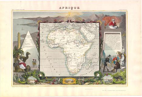
-
109182 item(s)/page