

America.- Kitchin (Thomas) A New and Accurate Map of the British Dominions in America, According to the Treaty of 1763; Divided into the Several Provinces and Jurisdictions..., scarce unrecorded map of the British Colonies showing west to include much of Texas and the lower Missouri River, decorative rococo title cartouche in the lower right, engraving with some outline hand-colouring, on laid paper with Strasbourg Lily watermark, sheet 555 x 650 mm (21 3/4 x 25 1/2 in), old folds with some white heightening to cover surface dirt, perforation and small loss with restoration visible in the lower left corner, otherwise handling creases, surface dirt, edges with minor nicks reinforced verso, unframed, [circa 1766] § Bowen (Emanuel) A New General Map of America. Drawn from Several Accurate Particular Maps and Charts, and Regulated by Astronomical Observations, engraving with hand-colouring, sheet 375 x 460 mm (14 3/4 x 18 in), several areas of loss and restoration visible, surface dirt and browning, unframed, [1757] (2)
We found 108737 price guide item(s) matching your search
There are 108737 lots that match your search criteria. Subscribe now to get instant access to the full price guide service.
Click here to subscribe- List
- Grid
-
108737 item(s)/page

NO RESERVE World.- Buffier (Claude) Geografia universale esposta ne' differenti modi che possono abbreviare lo studio, e facilitar l'uso di questa scienza, fourth Italian edition, title, 18 engraved folding maps only, including a double-hemisphere world map, Britain, Asia, America, and Europe, missing front free endpapers, spine and upper cover loose, map of Germany split along fold, otherwise occasional handling creases and small splits to folds, spotting and browning throughout, contemporary vellum, spine with title inscribed in black ink, rubbed and worn, 8vo, Venice, Bartolomeo Roselli, 1751.

America.- Gray (O.W.) Gray's Atlas of the United States, with General Maps of the World, title, with 73 hand-coloured lithographed maps and city plans, 23 double-page and one folding, business directory for Boston, Massachusetts and Connecticut at end, some light spotting or browning, first leaves brittle with a few small tears at edges, front free endpaper detached, small tear into map of Minnesota, other occasional nicks and tears to edges throughout, modern half calf over original cloth boards, cloth a little rubbed and faded, folio, Philadelphia, E.D. & H.C. Marsh, 1877.
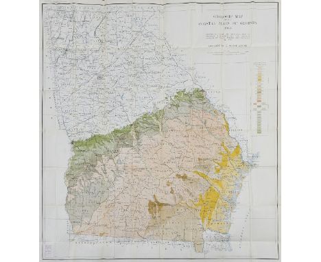
NO RESERVE America.- Mining.- Georgia Div. of Mines (publisher) Geologic Map of the Coastal Plain of Georgia 1944, detailed plan with explanatory key, from United States Department of the Interior Geological Survey, Bulletin 941, lithograph by A. Hoen & Co., printed in colours, on thin wove paper, sheet 1030 x 1115 mm (40 1/2 x 43 3/4 in), folding with some handling creases, ex-library stamps of 'The Institution of Mining and Metallurgy, London' on verso, without slip-case or covers, 8vo, 1944.

South America.- Jansson (Jan) Paraguay, o Prov. de Rio de la Plata cum Regionibus Adiacentibus Tucuman et Sta. Cruz de la Sierra, map of the Paraguay River basin and the Peru-Chilean coast with Lake Titicaca, engraving with hand-colouring, platemark 385 x 500 mm (15 1/8 x 19 3/4 in), full margins, Latin text verso, central vertical fold with careful repairs, some spotting and browning, unframed, [circa 1640].

South America.- Brazil.- Jansson (Jan) Guiana sive Amazonum Regio, map of Guiana illustrating the coastline from the Isla Margarita in the northwest to the coast of northern Brazil near Sao Luis east of the Amazon delta, engraving with hand-colouring, platemark 370 x 490 mm (14 1/2 x 19 1/4 in), full margins, Latni text verso, central vertical fold with expert repairs, minor spotting and light surface dirt, unframed, [circa 1650].

South America.- Mining.- Jansson (Jan) Peru, map oriented with north to the left, showing the Pacific coast of South America from Ecuador as far south as the Atacama Desert in the northern reaches of Chile, and includes the Potosi silver mines, Titicaca, Cusco, Quito and numerous other towns and villages, engraving with early hand-colouring, on laid paper without watermark, platemark 380 x 490 mm (15 x 19 1/4 in), Latin text verso, central vertical fold with expert repairs to old splitting, some old damp-staining to upper section, minor spotting and surface dirt, unframed, [circa 1650].

Asia.- Speed (John) Asia with the Islands adjoyning described, the atire of the people & townes of importance, carte-a-figure map, with ten costumed figures to the vertical margins and eight oval vignettes of principal cities along the upper margin, engraving with full hand-colouring, sheet 410 x 540 mm (16 x 21 1/4 in), under glass, laid onto support, central vertical fold with repairs to splitting, several areas of restoration to loss and minor nicks, old handling creases, framed, George Humble, [1627]

Asia.- Blaeu (Johannes) Tartaria sive Magni Chami Imperium, map of Tartary showing all of eastern Asia between the Caspian Sea and northern China and Manchuria, decorative title with camel in lower right, engraving with hand-colouring, platemark 385 x 500 mm (15 1/4 x 19 3/4 in), numerous repaired tears and carefully restored loss, handling creases and cockling throughout, minor surface dirt, unframed, [circa 1635].

Asia.- Thevenot (Melchisédec) Imperii Sinarum nova descriptio, large map of China, including Korea, Formosa (Taiwan) and Japan, published in the collection of 'Relation de Divers Voyages Curieux', engraving with hand-colouing, on laid paper Maltese cross within a rosary watermark, platemark 460 x 640 mm (18 x 25 1/4 in), old folds and handling creases, minor nicks to extremities, with light cockling with the margins, minor surface dirt, unframed, [Paris, 1663].⁂ Scarce at auction.

Asia.- Homann (Johann Baptist) Recentissima Asiae Delineatio, map of Asia showing from Egypt across the Arabian Peninsula, India, China, and Japan, decorated with two large cartouches, engraving with early hand-colouring on laid paper, platemark 495 x 590 mm (19 1/2 x 23 1/4 in), sheet 540 x 620 mm (21 1/4 x 24 1/4 in), colour key in German pasted onto lower margin, some surface dirt and browning, minor marginal nicks and tears to extremities, unframed, Nuremberg, [circa 1750].

Asia.- Lizars (W.) and others. Five maps of China, including Lizars' map of the mainland, Robert Wilkinson's 'China, Contains 15 Subject Provinces', 2 maps of mainlaind China by Fullarton & Co., and another, engravings, some hand-colouring to first mentioned, various sizes, minor spotting and browning, light handling creases, all unframed, [19th century] (5)
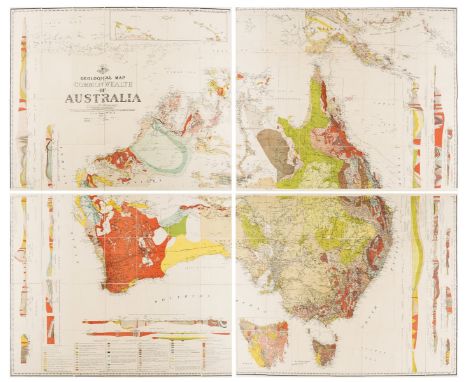
Australia.- Geology.- David (Sir Tannatt William Edgeworth) Geological Map of the Commonwealth of Australia, large colour-printed geological map of Australia in 4 sections, each linen-backed, some very light foxing, in original cloth box (rather stained, extremities worn), 1931; Explanatory Notes to accompany a New Geological Map of the Commonwealth of Australia, plates, illustrations and tables, some folding, library blind-stamp to title and ink withdrawn stamps to verso and endpaper, original cloth, rubbed and faded, Sydney, 1932

NO RESERVE World.- Crozat (Mme) Méthode abrégée et facile pour apprendre la Géographie, title, 17 folding engraved maps, including a double-hemisphere world map, and other maps of Britain, Asia, and America, occasional spotting and browning, some handling creases, title with owner's ink inscription 'Mademoiselle du Boisberrangeo', further ink inscriptions on front pastedown, near contemporary calf, very rubbed and worn, 8vo, Paris, 1770.
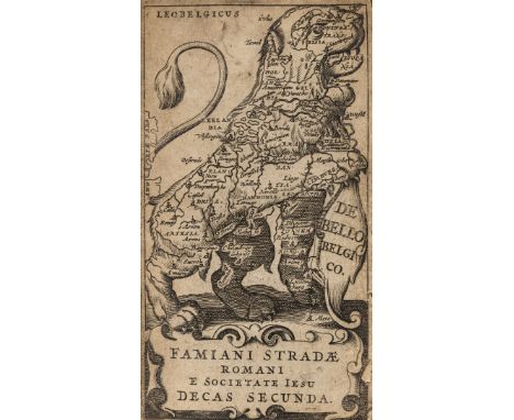
Europe.- Strada (Famiano) Famiani Stradae Romani e Societate Jesu de Bello Belgico, zoomorphic map of Belgium frontispiece, title, 9 engraved portrait plates only, nicks, tears, surface dirt and browning throughout, largely disbound, spine missing and splitting, lacking covers, very worn, 12mo, Corbelletti, Rome, 1643; together with Samuel Butler's An Atlas of Antient Geography, 1853, V. Monin's Petit atlas national des départements de la France et de ses colonies, 1833, the ninth edition of Guy's School Geography, on a New and Easy Plan, circa 1810, a copy of Plans of the most important Cities and Towns of Continental Europe, accompaning the special edition of Bradshaw's Continental Railway, Steam Transit, &c., Nicholas de Fer's [Les Forces de l'Europe, ou Description des Principales Villes avecs leurs fortifications ... pour l'usage de Monseigneur Le Duc De Bourgogne], 86 plates only, some folding, various repairs throughout to nicks, tears, and some loss, some leaves laid on support, otherwise surface dirt and browning, near contemporary calf, gilt, very worn, oblong 4to, [circa 1705-1710]; and volume 29 from Didot's Histoire General des Voyages... (7)

France.- Paris.- Blaeu (Johannes) Le Govvernement de l'Isle de France, north central region of France including Paris, large decorative cartouches, engraved map with original hand-colouring, 410 x 520 mm (16 1/4 x 20 1/2 in), wide margins, central vertical fold with marginal splitting to lower section, some nicks to extremities, handling creases, minor surface dirt, unframed, [Amsterdam, circa 1640]

France.- Paris.- SDUK (Society for the Diffusion of Useful Knowledge) Western Division of Paris. Containing the Quartiers; Eastern Division of Paris. Containing the Quartiers, two-part map, engraving with some hand-colouring, each sheet approx. 415 x 360 mm (16 1/4 x 14 1/4 in), minor browning and surface dirt, unframed, [1835]; together with a general map of France, France Comparative en Provinces et en Départemens, engraving with some hand-colouring, sheet 395 x 430 mm (15 1/2 x 16 7/8 in), unframed, [circa 1820] (2)

NO RESERVE France.- Paris.- Logerot (Auguste, publisher) Plan de Paris et ses Fortifications, engraved map, c.715 x 1000mm., hand-coloured in outline, engraved illustrations of buildings, a little light staining, linen-backed and dissected, original engraved label verso, folding into contemporary card chemise and slip-case, 1 joint split, rubbed, Paris, [c.1840].

Gibraltar.- pre-American Revolutionary War "Great Siege".- Lattré (Jean) Plan du Promontoire de la Ville et du Port de Gibraltar..., map of the town, port, and peninsula of Gibraltar, with the positions of Spanish and British during the stalemate of 1727, descriptive text below in French, engraving with hand-colouring, sheet 465 x 625 mm (18 1/4 x 24 1/2 in), on laid paper without watermark, folds and handling creases, some spotting, minor nicks, mainly to extremities, light browning and staining, not dated and 'du Roy' scraped from lettering, ink inscription verso that reads 'Gibraltar 1823', unframed, [circa 1770 or slightly later].

Greece & The River Danube.- Homann (Johann Baptist) Fluviorum in Europa Principis Danubii cum Adiaceniibus Regnis, nec non Totius Graeciae et Archipelagi Novissima Tabula, map of Italy, Greece, Sicily, Sardinia, Corsica, Hungary, a portion of Turkey and the Balkans, engraving with hand-colouring, sheet 525 x 600 mm (20 3/4 x 23 3/4 in), central vertical fold with some repairs to splitting, handling creases, minor surface dirt and browning, unframed, Nuremberg, [circa 1716].

Holy Land.- Conder (Thomas) A Map of The Land of Canaan, engraving with hand-colouring, 350 x 360 mm (13 3/4 x 14 1/8 in), old folds as issued, handling creases, spotting and surface dirt, unframed, C. Taylor, 1799; together with 2 further maps of the region, including Samuel Dunn's 'Part II of the Compleat Map of the Holy-Land', 1774, and 'A Plan of Mount Tabor and the parts adjacent' by another hand, engravings, 360 x 510 mm (14 1/8 x 20 in), and 390 x 440 mm (15 1/4 x 17 1/4 in), both unframed, late 18th century (3)

India & Sri Lanka.- Homann Heirs (publisher) Peninsula Indiae citra Gangem, hoc est Orae Celeberrimae Malabar & Coromandel, map of the southern part of India and Sri Lanka, with colonial possessions and trading posts delineated with flags along the coastline, decorative title cartouche with elephant in the lower left corner, engraving with hand-colouring on laid paper with watermark, platemark 570 x 505 mm (22 1/2 x 19 7/8 in), sheet 635 x 520 mm (25 x 20 1/2 in), central horizontal fold as issued, minor spotting, surface dirt, and some toning, extensive ink marginalia, some handling creases and surface dirt, unframed, 1733; together with Isaac Tirion's Nuova Carta dell' Impero del gran Mogol, and Jan Jansson's map of the Gulf of Bengal, Sinus Gangeticus Vulgo Golfo de Bengala Nova Descriptio, the last mentioned laid on board, unframed, 17th and 18th century (3)

India.- Vaugondy (Gilles Robert de) Presqu'Isle des Indes Orientales, Comprenant l'Indostan ou Empire de Mogol..., map of India and Sri Lanka with an inset detail of the Ganges delta as far as Calcutta, with decorative title cartouche and vignette showing an elephant, engraving with hand-colouring on laid paper with with watermark, platemark 505 x 650 mm. (19 7/8 x 25 1/2 in), small margins, trimmed to platemark at upper edge, minor nicks and losses to extremities, faint toning and surface dirt, unframed, Paris, Boudet, 1786

NO RESERVE Italy.- Jaillot (Alexis-Hubert) Le Royaume de Naples divise en toutes ses Provinces dedie a Sa Majesté Catholique Philippe, V. Roy d'Espagne, large four-sheet map of Southern Italy, showing part of Sicily, engraving on thick laid paper, platemark 890 x 750 mm (35 x 29 1/2 in), sheet 955 x 800 mm (37 1/2 x 31 1/2 in), some minor splitting and perforations along old folds, some handling creases, minor surface dirt, unframed, [circa 1703-1706].

Low Countries.- Keere (Pieter Van Den) Brabantia Ducatus, map of the county of Brabant with north oriented to the east, with three inset views of Mechelen, Antwerp and Brussels in the upper right corner, engraving with hand-colouring, sheet 375 x 530 mm (14 3/4 x 20 7/8 in), laid onto board support, central vertical fold with old splitting visible, parallel creases and abrasion, some surface dirt, unframed, [1617].

Middle East.- Münster (Sebastian) Tabula Asiae V, early map of the region between the Persian Gulf and the Caspian Sea, from 'Geographia', woodcut on laid paper, sheet 290 x 360 mm (11 1/2 x 14 1/4 in), some ink marginalia and inscriptions, minor spotting and surface dirt, unframed, [Basel, circa 1542].

World.- Sartine, Comte d'Alby (Antoine de) Carte Reduite Des Parties Connues Du Globe Terrestre Dressee au Depost des Cartes Plans et Journaux de la Marine . . . MDCCLV, large format map of the World on Mercator's projection, engraving on thick laid paper with large armorial watermark, platemark 560 x 830 mm (22 x 32 3/4 in), sheet 635 x 930 mm (25 x 36 1/2 in), central vertical fold with careful repairs to splitting, parallel crease to the left, other minor handling creases and surface dirt, unframed, Depot de la Marine, 1784; together with two other World maps, including SDUK's The World on Mercator's Projection, and a pictorial French map Planisphere, all unframed, 19th century (3)
![Middle East.- Fries (Lorenz) [Asiae tabula quinta continentur Assyria, Media, Susiana, Persis, Parthia], Ptolemaic map of Per](https://cdn.globalauctionplatform.com/eff35113-8b54-422b-80c6-ace200c8f050/793c3362-852e-4dca-8775-ace200cb54f7/468x382.jpg)
Middle East.- Fries (Lorenz) [Asiae tabula quinta continentur Assyria, Media, Susiana, Persis, Parthia], Ptolemaic map of Persia, woodcut on laid paper with watermark of grapes, sheet 398 x 570 mm (15 3/4 x 22 1/2 in), central vertical fold with minor splitting, scattered spotting and surface dirt, unframed, [circa 1540].

NO RESERVE Middle East.- Homann (Johann Baptist) Accurate Vorstellung der Orientalisch Kayserlichen Haupt- und Residenz-Stadt Constantinopel..., map of the environs of Istanbul, with inset bird's-eye view of the Bosphorus showing sailing ships, and panoramic view of the city below, engraving with hand-colouring, on laid paper with large armorial watermark, platemark 500 x 590 mm (19 3/4 x 23 1/4 in), sheet 530 x 640 mm (20 7/8 x 25 1/4 in), central vertical fold, some minor handling creases, some spotting and small rust spots, other minor surface dirt, unframed, Nuremberg, [circa 1720].

Middle East.- Jansson (Jan) Persia, Sive Sophorum Regnum, map of the Persian Empire during the time of the Safavid dynasty, showing from the Caucasus to India, with the Persian Gulf coastline of the Arabian peninsula, engraving with hand-colouring, on laid paper without watermark, platemark 375 x 490 mm (14 3/4 x 19 1/4 in), full margins, Latin text verso, central vertical fold with expert repairs to old splitting, marginal nicks and tears repaired, some spotting and minor surface dirt, unframed, [circa 1650].

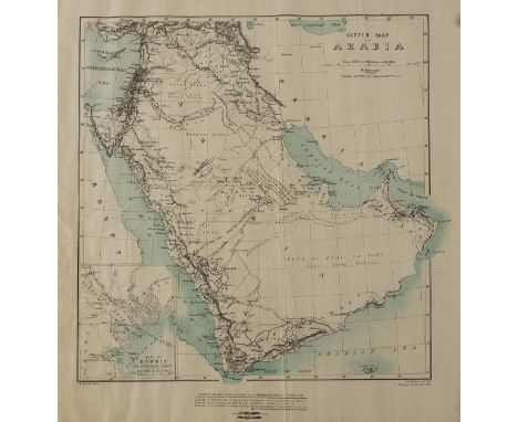
Middle East.- War Office (Geographical Section) Sketch Map of Arabia, map of the peninsula, with inset map of 'Koweit', several black ink inscriptions and annotations, lithograph printed in blue and black, sheet 490 x 475 mm (19 1/4 x 18 3/4 in), nicks and tears to extremities, some handling creases and minor surface dirt, unframed, 1835 with corrections July, 1905, Railways revised Sept. 1906; together with an Indian map of Baluchistan, heliozincographed at the Survey of India Office, Calcutta, 580 x 455 mm (22 3/4 x 17 7/8 in), folding into brown paper ends with title printed on upper cover, published under the direction of Col. F. B. Longe, R.E., Surveyor General of India, 1910 (2)
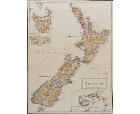
New Zealand.- Hockin (W. R. C.) New Zealand, manuscript map of the two islands, with inset maps of Tasmania and Fiji, pen and black ink, watercolour, with brown ink identifying routes and distances, black ink framing lines, signed and dated in the lower right corner, 410 x 310 mm (16 1/8 x 12 1/4 in), laid onto card support verso, old mount affixed to recto, spotting and browning throughout, some surface dirt, unframed, 1909.

Poland.- Münster (Sebastian) Poloniae et Ungariae Nova Descriptio, map of the region containing present-day Romania, Moldova and Ukraine, with parts of Poland, Slovenia and Hungary, woodcut map on laid paper without watermark, sheet, 310 x 395 mm (12 1/4 x 15 1/2 in), minor handling creases and light surface dirt, unframed, [Basle, circa 1550].

World.- Butler (Samuel) A General Atlas of Ancient and Modern Geography, engraved title, index and 43 maps, by Sidney Hall, including a double-page double hemisphere map of the World, and with ancient and modern maps of Europe and the British Isles, all with original outline hand-colouring, occasional spotting and minor browning, slight offsetting to some maps, particularly to title, contemporary half-calf, marble covered boards with printed title pasted on, rebacked, covers worn, 4to, Longman, Hurst, Rees, Orme, Brown and Green, 1825.
![West Indies.- Speed (John) A Map of Jamaica [on sheet with] Barbados, 2 maps on 1 sheet, each with decorative title cartouch](https://cdn.globalauctionplatform.com/eff35113-8b54-422b-80c6-ace200c8f050/9c8c2e32-d2a6-45c0-9a6c-ace200cb68cc/468x382.jpg)
West Indies.- Speed (John) A Map of Jamaica [on sheet with] Barbados, 2 maps on 1 sheet, each with decorative title cartouches, compass roses, ships and sea monsters, engravings with hand-colouring, 425 x 530 mm (16 3/4 x 20 7/8 in), English text verso, central vertical fold with minor browning, parallel printers' crease, small nicks and tears to extremities, two small worm holes in each of the lower corners, unframed, Bassett and Chiswell, [1676]
![Ireland.- Malton (James) [A Picturesque and Descriptive View of the City of Dublin], engraved title, 2 aquatint plans, full-p](https://cdn.globalauctionplatform.com/eff35113-8b54-422b-80c6-ace200c8f050/8c5d5bc5-0ffd-441d-b2d2-ace200cb3b73/468x382.jpg)
Ireland.- Malton (James) [A Picturesque and Descriptive View of the City of Dublin], engraved title, 2 aquatint plans, full-page aquatint vignette of the Arms of the City of Dublin, folding map of Dublin by William Faden dated 1797, and some text leaves only, lacking lacking dedication and without any of the 25 views of Dublin, the map sheet 530 x 780 mm (20 7/8 x 30 3/4 in), laid on linen and mounted in stub, some small loss to centre left restored, other repaired tears and surface dirt to map, otherwise damp-stains to title, plans and throughout, repaired tears and loss, surface dirt and scuffs throughout, largely disbound, lacking covers and spine, oblong folio, [circa 1792 and slightly later]; and another copy of the same, containing engraved title, 2 aquatint plans and text only, oblong folio (2)
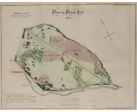
Ireland.- A collection of 7 folding maps, extracted from Parliamentary Reports, together with some of the text reports, including three maps on developments to Phoenix Park, Dublin, and its environs, one of King's Island, Limerick, and others including one of Scottish interest showing River Tay, Dundee, lithographs, some hand-colouring, various sizes, some handling creases, minor off-setting, surface dirt, unframed, [circa 1844-1853]; together with Edward Stanford's Map of Ireland, lithograph printed in colours, 1020 x 805 mm (40 1/8 x 31 3/4 in), dissected and mounted on linen, some surface dirt and minor browning, folding with publisher's labels to ends, with original green slip-case with publisher's yellow label to upper cover, 8vo, [circa 1890s] (8)

Wales.- Ortelius (Abraham) Cambriae Typus Auctore Humfredo Lhuydo Denbigiense Cambrobritano, map of Wales, with details of mountain ranges, forests, and towns, strap-work title cartouche, sea monster, and ship off the coast, engraving with early hand-colouring, on laid paper with indistinct armorial watermark, platemark 375 x 495 mm (14 3/4 x 19 1/2 in), small margins, Latin text verso, some expert repairs to splitting and perforations, minor surface dirt, unframed, [Antwerp, circa 1590s].Literature:VdB 21

British Isles.- Blaeu (Johannes) Britannia prout divisa suit temporibis Anglo-Saxonum praesertim durante illorum Heptarchia, map of the British Isles, margins decorated with 14 scenes of Saxon figures and events, engraving with hand-colouring on laid paper with large armorial watermark, platemark 415 x 530 mm (16 1/4 x 20 7/8 in), under glass, minor spotting and surface dirt, framed, [circa 1645]

British Isles.- Blaeu (Johannes) Insulae Albion et Hibernia, Ptolemeaic map of the British Isles, engraving with hand-colouring, platemark 380 x 440 mm (15 x 17 1/4 in), central vertical fold with splitting to edge, marginal nicks and tears, some browning, off-setting, and surface dirt, unframed, [circa 1645].

British Isles.- Speed (John) The Kingdome of Great Britaine and Ireland, map with strapwork title cartouche, inset views of London and Edinburgh, small map of the Orkneys, and decorated with ships and sea-monsters, engraving by Joducus Hondius, with hand-colouring, 415 x 525 mm (16 1/8 x 20 3/4 in), English text verso, central vertical fold reinforced verso with careful repairs to splitting, some handling creases and minor restoration to extremities, unframed, William Humble, 1653.

British Isles.- Ortelius (Abraham) Britannicarum Insularum Typus, map of Roman Britain based on information from Mercator's 1564 map of the British Isles, oriented with north to the right, three decorative strapwork cartouches, numerous sailing ships, engraving with hand-colouring on laid paper with crossed arrows watermark, platemark 370 x 510 mm. (14 1/2 x 20 in), sheet 435 x 550 mm. (17 1/8 x 21 5/8 in), Latin text verso, central vertical fold as issued, minor marginal nicks, some surface dirt and light browning, unframed, [circa 1595 or slightly later].
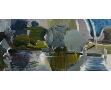
λ Ivon Hitchens (British 1893-1979)Wittenham Clumps from Day's LockOil on canvasSigned (lower left); further signed, titled and dated 1956 (on artist's label to stretcher)41 x 87cm (16 x 34¼ in.)Provenance:Acquired directly from the artist in 1957Thence by descent to present ownerSynonymous for his panoramic depictions of the English countryside, Ivon Hitchens learnt his trade at the Royal Academy Schools before setting up a studio in north London in 1919. The subsequent two decades saw the evolution of Hitchens' style from an accomplished but essentially traditional representational approach to a much more personal and emotive pictorial language. The influence of contemporary French painters such as Paul Cezanne, Georges Braque and Andre Lhote, as well as friendships with confirmed modernists like Claude Flight exposed Hitchens to new and exciting ways of seeing. An invitation to stay with Ben and Winifred Nicholson at their house in Cumberland in 1925 led to a productive exchange of ideas at a time when all three were at a critical juncture in their artistic development. The paintings that Hitchens completed during this time have often been seen as the first in which his personal style begins to manifest itself. These years were, however, a financial struggle for Hitchens who, lacking any significant patronage, had to be content with only selling a handful of works each year. The one constant was his membership of the Seven and Five Society. With its first exhibition in 1920, the group was initially made up of a haphazard variety of artists, but Hitchens' suggestion that Ben Nicholson join the group in 1925, galvanised it into a more single-minded movement with a nascent modernist aesthetic. Over the coming years the group attracted many of the most innovative artists of the period including Christopher Wood, David Jones, Frances Hodgkins and Barbara Hepworth; and Hitchens' circle in north London grew to include further likeminded artists and intellectuals such as Henry Moore, Paul Nash, Adrian Stokes, David Bomberg, Walter Gropius and Herbert Read.In 1940, the Hitchens family which now consisted of his wife Mollie whom he had married in 1935 and their young son, John, born in April of the same year, were forced to retreat from London after his Hampstead studio and home was bombed. The couple had been spending increasing time in Sussex and the previous year had acquired an area of woodland near Lavington Common, along with a large caravan purchased from a Miss Williams of Heyshott for £20. This move to Sussex transformed Hitchens' painting and he spent the next forty years depicting the surrounding landscape.By the time of the present work, Wittenham Clumps from Day's Lock, executed in 1956, Hitchens had established himself as one of the foremost painters of the day, with financial security from a now longstanding relationship with Leicester Galleries and critical acclaim from several museum exhibitions. In the same year, he was chosen to represent Britain at the XXVII Venice Biennale. Whilst his work had been exhibited abroad, the Biennale offered an unrivalled opportunity for twenty canvasses to be shown, showcasing his work to a much wider international audience. The works were well received and, following the show, the British Council was invited by several European galleries, to send them on tour, garnering yet more exposure for Hitchens' work. Wittenham Clumps from Day's Lock is a superb example of Hitchens' use of colour to create form. The typical sage green interspersed with greys, whites and violets draw the viewer over the water to the landscape beyond. The intersecting lines of the foreground contrasting with the curve of the hills in the distance creating a sense of balance and harmony. The work was acquired in 1957 as a wedding present directly from Hitchens' studio and has remained in the same family ever since. The family have retained not only the original correspondence with Ivon Hitchens setting up the studio visit and subsequent purchase of the work but also a brilliant recollection of the visit by the original owner. These documents reveal him to be a solicitous and kindly man who was more than happy to devote the whole day to showing paintings to his prospectus buyers and discussing them at length. Although the letters deal mainly with the practicalities - including a hand drawn map of how to find the studio - they also reveal humour and sensitivity. Hitchens first letter, dated January 25th 1957, worries "Hadn't you better count your pennies after your honeymoon?".The timing of the visit coincided with the opening of Hitchens' exhibition at the Musée National d'Art Moderne in Paris and he remarks:"...it's odd how you can travel thousands of miles, do and see so much and find time for it all - while if one stays at home, things crowd in so thick and there is so much to attend to that I am usually behind with the delivery of paintings. Our Paris trip which did materialise in the end, leaves a hazy memory of floods of taxis (petrol rationing a myth), crowds of people, champagne adlib(?) and miles of stone floor galleries. The show looks well and everyone seemed pleased including the museum authorities who talk of buying one."The owner's memoir reveals more about the visit and includes a great many insights into Hitchens' working process."He seemed in no hurry, and curiously objective about his own work as though he were an outsider seeing it for the first time. Many canvasses were unfinished. He explained that he always knew what he was going to try to achieve but never how he was going to get there. He always started from nature (or from an interior or model). The first rendering was often relatively representational, the verticals and horizontals, light and shade, re-producing what was in front of him - up to a point.Each succeeding state - and he sometimes did 6 or more - would be more abstract, until the final one might, if he were 'lucky' express something of what the original meant to him, though, to the viewer, it might seem to be totally 'abstract' unless he knew how it had evolved."It was only after some considerable time that they came close to making a decision on a painting and, remarkably, the day ended with them agreeing on not just one painting but two:"We spent the whole afternoon, looking at and discussing painting after painting. Eventually the choice was narrowed to two; one I liked, one Hitchens liked and wanted us to have. The one I liked was not, Hitchens said, finished - or satisfactory. The one Hitchens preferred had just been completed - 'Wood Landscape no. 2', of 1956. He looked again at the one I preferred - 'Day's Lock, Wittenham Clumps' - and agreed there was something missing on the right-hand side. Picking up a large brush dripping with a characteristic mixture of grey, light blue and purple, he swirled in a sort of arching rainbow against the deep blue of the sky on the right. "There", he exclaimed, "That does it, I think". I wanted the picture more than ever, but he still wanted us to have the other. We explained that we were broke and could not possibly afford both. After long discussion, "I'll tell you what", he said, "why don't you take both - for the price of one". And, despite our protests, that is what eventually happened."

BRAUN & HOGENBERG; 'Cestria (Vulgo) Chester, Angliae Civitas', a circa 1575 hand coloured map of Chester, with text titled 'Cestria' verso, 31.5 x 42.5cm, framed and glazed.Additional InformationBrowning, slight waviness to paper, some pinprick holes, central fold, slight separation lower centre of fold, general wear to frame, crack to glass reverse lower right. Staining and discolouration throughout the image. There is an old rip to the centre right of the image. Measurements including frame 42 x 54.5cm. As catalogued, this is an original map.


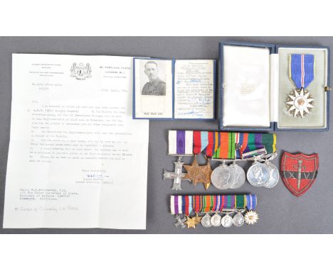
A WWII Second World War interest medal group and archive of related effects, to one 158222 Captain (later Major) William Gordon Tollworthy of the Royal Engineers who served in Burma from 1942-45 and was head of Military Intelligence in Perak (and took part in Operations Juno and Jetsam) as part of The Malayan Emergency in 1956-58. The medal group comprising; Military Cross, 1939-45 STar, The Burma Star, Defence Medal, War Medal (with oak leaf for a mention in despatches), QEII General Service Medal (with Malaya clasp and impressed Capt WG Tollworthy MC RE), George VI Territorial Efficiency Medal (impressed ditto) and Pangkuan Negara medal (Order Of The Defender Of The Realm). All with ribbons, and mounted on bar, and with their original set of miniature medals. The Military Cross comes with its original citation which, in part, reads; 'During the operations of 51 Indian Infantry Brigade at KANGAW from 27th January for a period of fourteen days, constantly under fire of every nature, he worked with unfailing energy and determination, both by day and by night with little rest. He frequently visited all areas from the beach to the forward troops, supervising the landing of heavy equipment, the development of water points, the construction of bridges and tracks and the demolition of enemy bunkers and ammunition dumps.' The medal group comes with a wealth of paperwork, effects and history - all related to Tollworthy, and includes; - Tollworthy's Perak Combined Operations Room Pass - A box of Tollworthy's cap badges, uniform patches and other such items - A small silver white metal presentation statue engraved 'Presented To Major W.G. Tollworthy 63 Ind. Fd. Coy. Burma 1944-1945' - a post-war presentation Kundo mantel clock engraved to the top ' Presented To Major WG Tollworthy MCRE by 39 FD SQN RE, 8th Sep, 1960' - a typed copy of ' The Military Memoirs Of Major WG Tollworthy ' - based on tape recordings made by his family in 1996. The memoirs detailing his entire life and military career in great and personal detail. Also included are several copied drafts of the memoirs. - an original captured C96 'Broomhandle' Mauser detachable wooden stock / pistol case (no pistol present) - Five folders of period-written (mostly handwritten) documents written by Tollworthy during Operation Junto (some marked 'Top Secret') - includes some letters written by those arrested, various official documents, orders, notes, letters etc. As well as copious handwritten notes, encounters and other such entries. - a 'Confidential' marked map showing the District Boundaries in Perak Police Contingent Operational Area with hand-drawn additions by Tollworthy - an original edition of 'In Defence Of Singapore - A Series Of Drawings With Brief Notes' - an envelope of photographs of Malayan soldiers / civilians - each with code numbers present to the images (presumably for identification purposes) - Various handwritten lists of ' Jetsam Surrenders ' - which appears to detail the individual details of those who surrendered during Operation Jetsam (some marked 'Surrendered To SAS'), - Photocopies of 1930s / Wartime sketches that Tollworthy drew in a friend's autograph book (with accompanying letter) - Tollworthy's 1919 dated hallmarked silver miniature tankard (likely a Christening tankard) - A large box-file of maps, documents and other items relating to the Policing of Perak and other such items including details of communist terrorist captures, interrogations, and captured CT hand-drawn maps of jungle routes, camps etc. - a quantity of intricately drawn jungle maps confiscated from terrorists during Junto - various paperwork relating to his MC including the official letter from King George An interesting piece of history within the collection is perhaps a copy of an original Japanese diary that Tollworthy once discovered when on service in the Burmese jungle during WW2. Tollworthy kept hold of the diary for many years, and in the 1990s - with the help of The Daily Telegraph - Major Tollworthy was able to reunite the diary with the family of its original owner. Lots of documents relating to the diary are included, as well as a photocopy of the entire diary itself, and a photograph of Tollworthy with the Japanese family who came over to visit him. Newspaper cuttings and related letters are also present. The entire archive makes fascinating reading, and is perhaps the most poignant factor in the collection. (more can be read about the diary here: www.olioo-me.medium.com/never-forget-that-of-250-only-20-survived-diary-of-emon-tochio-9ccfe41780f4) The entire collection - which must be considered as Tollworthy's complete military career archive from 1942-1965 - is one of the most interesting, and most important collections we have ever seen. A truly unique archive, with well over 500 individual documents and supporting items of great historical importance.

The Dam Busters (1955) - collection of memorabilia relating to the film, and the real-life Operation Chastise. The collection comprising: an original autographed photograph of Richard Todd (framed with Dam Buster related cuttings), an original advertisement for the movie, and an original 1940 War Revision issue paper map showing Lincoln, including RAF Scampton. Interesting collection.
-
108737 item(s)/page