We found 109198 price guide item(s) matching your search

Refine your search

Year

Filter by Price Range
  • List
  • Grid
  • 109198 item(s)
    /page

Lot 262

NO RESERVE Scotland.- Orkney & Shetland Islands.- Blaeu (Willem Jansz.) Orcadum et Schetlandiae..., engraved map with original hand-colouring, platemark 405 x 525 mm (16 x 20 3/4 in), sheet 530 x 620 mm (20 7/8 x 24 1/4 in), even toning and surface dirt, exposure lines, slightly brittle with some loss to corners and edges, unframed, [Amsterdam, circa 1650]

Lot 263

Scotland.- Ortelius (Abraham) Scotiae Tabula, map of Scotland, oriented with north to the right, with large strap-work title cartouche in the upper right corner, sea monster and ship, engraving with hand-colouring on laid paper with armorial watermark, platemark 352 x 474 mm (13 7/8 x 18 5/8 in), sheet 405 x 500 mm (16 x 19 3/4 in), Latin text verso, central vertical fold, minor handling creases, even toning and light surface dirt, unframed, [Antwerp, circa 1603].

Lot 264

NO RESERVE Scotland.- Salmon fishing.- Anonymous (c. 1780s) A Plan of Loch Lomond in Dumbarton Shire..., being one of the most Celebrated, Beautiful and Extensive, fresh water Lakes in Great Britain..., at the Head of the River Leven, there is the most Extensive Salmon Fishing in Scotland, engraving, sheet 345 x 270 mm (13 1/2 x 10 1/2 in), handling creases, some surface dirt, unframed, [c. 1788] together with Henry Teesdale & Co.'s Scotland, engraved map with full hand-colouring, sheet 670 x 540 mm (26 1/4 x 21 1/4 in), old folds, marginal loss to lower left replaced in facsimile, unframed, [circa 1820s]; and a large four-part map of Scotland by John Cary presented in two horizontal sections, each sheet 530 x 1050 mm (20 3/4 x 41 1/4 in), unframed, 1811 (3)

Lot 267

Staffordshire.- Plot (Robert) The Natural History of Stafford-shire, first edition, title with large engraved vignette, engraved plate of 'Armes omitted', folding map (linen-backed and inserted in pocket at end) and 37 plates by Burghers, of which 26 double-page (mostly houses), 4pp. list of subscribers at end, plate 'Tab. XI' at p.189 with purple damp-staining, 2E4 torn without loss of text, second f. of subscribers strengthened with tape (still legible), the odd short tear or repair, some spotting or mostly light staining, lightly browned, new endpapers, 20th century half morocco, [Wing P2588], Oxford, At the Theatre, 1686; and a defective copy of Leigh's Natural History of Lancashire, 1700, small folio (2)⁂ By the first keeper of the Ashmolean Museum, Oxford. Includes two chapters on minerals and fossils. Subscribers include Elias Ashmole and Robert Boyle.

Lot 65

France.- Manuscript estate maps.- Marche (Lecoy de la) [Survey of the estates of Château-Renault], manuscript, double-page preface and 2 tables, 9 double-page hand-coloured maps (numbered 2-10, as per detailed preface and first table), each c.530 x 730mm., map 6 with hand-coloured addenda tipped-in, 2 additional related hand-coloured maps (1 bound in and 1 loosely inserted), damp-stained / some chipping, mostly marginal, but encroaching into border in places, some repairs, modern vellum-backed green cloth, printed label to upper cover, folio, 1814.⁂ A detailed survey of the estates of M. François Louis Barrairon and his wife of the Château-Renault in the Indre-et-Loire department of France. Loosely inserted are few related manuscripts and drawings by La Marche and his son.

Lot 148

published 1806, PRINTED for the PROPRIETORS, BOWLES and CARVER, No.69 St. Paul's Church Yard ... Roads and Distances ... agreeable to those given ... by Daniel Paterson, 69 cm x 68 cm, presented in the original cardboard sleeve; together with Railway Clearing House OFFICIAL RAILWAY MAP of the EAST of ENGLAND, chairman's copy [damage to the cover], maritime 1823 New and Correct Map of London Westminster and Southwark, plus earlier R. Wilkinson map of the same area dated 1787, a Royal Naval Boys Manual of Seamanship and Gunnery, fifth edition, and W.H. Smith map of the Thames (6)

Lot 113

A John Ogilby strip road map, The Road from Gloucester to Montgomery North Wales. 13½' x 18'. Stained

Lot 114

A John Speed coloured map of Shropshyre. 15' x 20'. Stained

Lot 702

An air raid warden's reference book with entries and hand drawn map, together with an air raid precautions certificate of appointment and Blunden, Edmund, 'Undertones of War', seventh impression, September 1929

Lot 66

ROBERT DODSLEY. London and Its Environs Described, 6 volumes, 1761. *CR Lacking map of the city, volume 6 chipped at foot of spine, slight marking and scuffing to leather.

Lot 166

R Blome, A Mapp of Warwickshire, hand coloured, 13ins x 11ins, together with a Robert Morden, hand coloured map of Warwickshire, sold by Abel Swale & John Churchil, 14ins x 16.5ins

Lot 170

An antique map, of the road from London to Aberistwith by John Ogiby Esq, Lond coloured, plate 2

Lot 343

A drawn map of the birthplace of Richard Trevithick together with a brief history of The Cornish Institute of Mining, Mechanical, & Metallurgical Engineers on a rolled manuscript. (2)

Lot 89

A Cornish mine map for Reeth Consols, printed by Waterlow & Sons, London, 48 x 60mm.

Lot 359

[TOPOGRAPHY]. SOMERSET & DEVONSHIRE Kelly's Directory of Somersetshire, 1906; with further editions for 1935; and 1939; together with Kelly's Directory of Devonshire, 1935, (4). Note: This lot sold with all faults, not subject to return. Condition Report : Bindings worn; all but 1906 lacking map. Condition reports are offered as a guide only and we highly recommend inspecting (where possible) any lot to satisfy yourself as to its condition.

Lot 363

[MAPS] After Jean-Baptiste Bourguignon d'Anville (French, 1697-1782), 'The Third Part of Europe', engraved map, hand-coloured in outline, published by Harrison, London, 1791, 75cm x 52cm, unframed (stained; lightly foxed); and two other, unrelated maps, (3).

Lot 366

[MAPS] Ortelius, Abraham (Brabantian, 1527-1598), 'Corfu', engraved map, 8cm x 11cm; together with Morden, Robert (English, c.1650-1703), 'The Canarie or Fortunate Ilands', engraved map, hand-coloured in outline, 19cm x 12.5cm; and two other maps after different hands, each framed and glazed, (4).

Lot 127

A linen backed pocket map of the Beaufort Hunt, produced by Houlston, Chippenham, with index to the meets, 45x50cm

Lot 128

A linen backed folding map of the Hursley Hunt, double sided, printed by Sifton Praed & Co, 68x32cm; together with one other similar, 61x61cm (2)

Lot 129

A double sided linen backed map of the Quorn hunt, 78x31cm

Lot 3

A framed and glazed 17th century hand drawn map showing the land owned by the Manor of Grove, with hand written description and dated 1635. Hand coloured scale and ledger. H.36 W.68cm

Lot 143

"Pavillons des principaux etats du globe". France, ca.1880.Lithographed plate.Authors: F. Courtin and Vuillemin.Some damp stains and damage.Frame with slight flaws.Measurements: 49 x 65 cm; 56 x 72 cm (frame).Lithographed plate with a wide display of flags of the nations of the world, published around 1880. The flags are broken down by region. At the top centre is a large compass rose on a world map.

Lot 144

Map of Holland, XVIIIth century.Colour engraving.Frame with xylophages.Moisture stains. Faults.Measures: 44 x 60 cm.; 53 x 68 cm.(frame).Engraving to colour with the indications in Latin, of the map of Holland, accompanied of royal crown and with representation of boats furrowing the sea.

Lot 145

Map of Africa. France, 1802.Colour engraving.Frame with xylophages.Moisture stains and soiling. Faults.Measurements: 52 x 70 cm; 59 x 77 cm (frame).

Lot 152

Map of the City of Tarragona. France, 19th century. Colour engraving.Frame with xylophages.Moisture and dirt stains.Measurements: 48 x 60 cm.; 59 x 77 cm.

Lot 320

Isaak Tirion: 18th century hand-coloured map "Groot Brittannien", in ebonised and gilt frame, and Richard Blome: a 17th century hand-coloured map of Cumberland, in ebonised and gilt frame (foxed and paper losses)

Lot 322

A 19th hand-coloured, map of Berkshire, in gilt frame, four unframed signed limited edition prints of St John's College by Michael Ewins, and another unframed limited edition print of Radley College, after G Pyne

Lot 323

A Saxton map of Berkshire, coloured boundaries, 9 1/2" x 13", in black and gilt frame

Lot 324

A Saxton map of Oxfordshire, coloured boundaries, 11" x 14", in black and gilt frame, a modern map of Oxford and another of Norfolk

Lot 455

Paul Spencer T - The Forester's Offering, engraved title and frontispiece, original stamped green cloth lettered gilt, London: Whitaker & Co, 1841, Henry Moore - Picturesque Excursions from Derby to Matlock Bath and its Vicinity being a descriptive Guide, engraved title and plates, later 4to calf, Derby 1818, Topographical and Statistical Descriptions of the County of Nottingham folding map, later half calf, London [1830], John Hicklin - The History of Nottingham Castle, engraved title, recent cloth, 1836, William & Mary Howitt - The Forest Minstrel and other Poems, half title, 19th c scarlet morocco, spine gilt with green label, London 1823, The Nottingham Annual Register.... and ... Directory for 1840 by James Orange, Nottinghamshire History Directory and Gazetteer... b y Francis & John White, contemporary calf, Sheffield 1844 and seven others of related interest (14)  

Lot 463

Deering (Charles) - Nottinghaemia Vetus et Nova or an Historical Account of the Ancient and Present State of the Town of Nottingham..., engraved map and plates, mottled calf rebacked, 4to, Nottingham: George Ayscough and Thomas Willington 1751 and Rupert Cecil Chicken - An Index to Deering's Nottinghamia Vetus et Nova, Nottingham 1899 (2)

Lot 471

Norwich printed. A General History of the County of Norfolk intended to convey all the information of a Norfolk tour.... two vols, engraved frontispiece, hand coloured folding map, contemporary green cloth with spine label, Norwich: John Stacy 1829

Lot 482

Joan Blaeu - Nottinghamshire, double page engraved map, 1646, hand coloured, 47 x 56.5cm Slightly stained, frame dirty and stained with birdlime, etc

Lot 486

John Speede - Derbyshire, double page engraved map, 1614, hand coloured, 39.5 x 52cm Slightly soiled and stained where creased

Lot 487

John Speede - Nottingham, double page engraved map, 1676, hand coloured, 40.5 x 53.5cm Slightly creased and stained

Lot 434

A small collection of assorted 18ct and 9ct brooches and pendantcomprising a brooch in the form of a folded umbrella marked 750, a pendant in the form of a map of Africa with suspension hook marked 18ct, a 9ct spray brooch set with pearls in the form of petals marked on the reverse 375, a 9ct filigree leaf brooch set with central faceted stone, bar brooch mounted with citrine and another brooch a/f (6)total weight 26g, first length 5.3 cm.Condition: The spray brooch with missing pearl and central stones. Umbrella brooch slightly bent out of shape.

Lot 585A

Maps, an Ordanance Survey war issue map for 1940 and two German war maps of the Orkney Islands. (3)

Lot 26

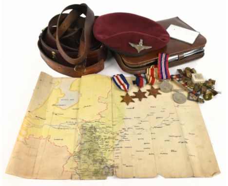
A Second War ‘Italian Operations’ D.S.O. group of eleven awarded to Sherman Tank Commander Major C. V. King, Prince Alfred’s Guard and Southern Rhodesian Forces, late Royal Navy, for his gallantry during the crossing of the Finale in April 1945; he had previously been wounded by shell fire on 3 June 1944 Distinguished Service Order, G.VI.R., silver-gilt and enamel, reverse officially dated 1945, with integral top riband bar; British War and Victory Medals (J.59714 C. V. King. Boy. 1. R.N.); 1939-45 Star; Africa Star; Italy Star; Defence and War Medals 1939-45, these all unnamed as issued; Africa Service Medal (SR.597707 C. V. King.) Coronation 1953, unnamed as issued; Efficiency Medal, G.VI.R., 1st issue, Southern Rhodesia (Major C. V. King D.S.O.) re-engraved naming, mounted court-style as worn, generally very fine and better (11) £1,800-£2,200 --- D.S.O. London Gazette 23 August 1945: ‘In recognition of gallant and distinguished services in Italy.’ The original Recommendation, for an Immediate Military Cross (subsequently upgraded to a D.S.O.), dated 11 May 1945, states: ‘For conspicuous gallantry, boldness, and devotion to duty. On the night of 22-23 April 1945, Major C. V. King was in command of a squadron of tanks ordered to support the Royal Durban Light Infantry in securing the road and bridge intersection at Finale (Map Ref. 866857). This objective proved to be a strongly held enemy rear guard position. Soon after darkness this strongly held position was overrun and the tanks had driven a wedge right into the centre against heavy opposition. Despite the darkness and lack of manoeuvre, owing to the impossibility of deploying the tanks off the road, Major King pressed his tanks forward through enemy infantry armed with bazookas, he himself moving with the leading troop. From here he was able to effectively engage an animal drawn convoy protected by enemy tanks. By this time the animal convoy had been cut in two, the leading tank began engaging Major King and the leading troop from two sides, resulting in two of our tanks being knocked out. The extent of the damage and loss off equipment caused to the enemy was evident the following morning when some fifty to sixty vehicles were found to be destroyed. During the confused fighting that lasted till 0300 hrs, Major King remained with his leading tanks, and his coolness and imperturbable courage during intensive tank and shellfire was an inspiration to his men, and an outstanding example of zeal and devotion to duty. He displayed an exceptional degree of tenacious courage and resourceful determination under the most adverse tank conditions. His personal bravery and leadership could not be surpassed.’ Cecil Vincent King was born on Robben Island, Cape Town, on 3 August 1900 and joined the Royal Navy as a Boy Second Class on 7 August 1916, serving initially in H.M.S. Hyacinth and H.M.S. Impregnable. He was advanced Boy First Class on 26 February 1917, and was promoted to Able Seaman on 3 April 1919. He was invalided out of the service, suffering from Rheumatism, on 10 December 1919. Having moved to Southern Rhodesia King saw early service in North Africa during the Second World War, before being assigned to the Prince Alfred’s Guard, with who he saw extensive service in Italy with the rank of Major, and was wounded on 3 June 1944 when his foot was crushed by a lump of flying earth thrown up by an exploding shell. For his services as a Sherman tank commander at the crossing of the Finale in April 1945 he was awarded the Distinguished Service Order; Neil Orpen’s Victory in Italy gives the following coda to his D.S.O. action: ‘Strewn among the wreckage of more than 60 enemy vehicles lay the corpses of Germans who had tried to hold open the line of retreat. The carcasses of horses and oxen killed in the night’s hail of crossfire sprawled among shattered lorries, carts, semi-tracked vehicles, guns, limbers and piles of wrecked enemy equipment of every conceivable kind. At the crossing point over the canal about 200 metres from the river, smashed carts, dead oxen, mules, and horses were so entangled with trucks and knocked-out assault guns and tanks that a bulldozer was needed to clear the way for the advancing columns. A ground check in the area immediately south-east of Finale showed enemy losses amounting to 51 guns, 17 mortars, 2 tanks, 17 half-tracks, 100 or more motor-drawn vehicles, and more than 150 horse-drawn vehicles.’ During the actual fighting the R.D.L.I. had taken 160 prisoners, and no fewer than 200 enemy dead were found on the battlefield, compared to the R.D.L.I. casualties of just 12 wounded.’

Lot 542

JOHN SPEEDE; a 17th century map of Yorkshire, 52 x 39cm, framed and glazed.

Lot 543

SAXTON & JOHN SPEED; a 17th century map of Montgomeryshire, framed and glazed.

Lot 544

JOHN SPEED; an 18th century map of Merionethshire, approx 40 x 54cm, and a map of Anglesey, 24 x 18cm, framed and glazed (2).

Lot 545

JOHN SPEED; a 17th century map of Denbighshire, approx. 40 x 53cm, framed and glazed.

Lot 549

BRADSHAW'S; a 19th century map of the railways in Great Britain, 38 x 47cm, framed and glazed.

Lot 71A

PRISONER OF WAR INTEREST, LIEUTENANT LAURENCE ATKINSON (1915-1978), a group of five WWII medals, with a small selection of buttons, a beret, three belts, a wash set and a hand drawn map titled 'Map used in Meiningen P.O.W Cap to note advances of allies 1945' (Quantity).

Lot 796

HALL (CAPTAIN BASIL), FRAGMENTS OF VOYAGES AND TRAVELS, including anecdotes of a naval life, five vols only, Vol I 1831, Vol I 3rd series with frontis map half title, 1833, Vol III 1831, Vol III 2nd series 1832 and Vol III 3rd series 1833, each with frontis engraved half title; with MAHAN (CAPTAIN A), THE INFLUENCE OF SEA POWER UPON THE FRENCH REVOLUTION AND EMPIRE 1793-1812, 2 vols (7).

Lot 89

A small group of military items comprising Home Guard map, RAF bag, a photograph of Francis Collins and his badges and buttons. 

Lot 93

A small collection of British and German militaria, including a 30th Corps District map of the North Sea, assorted cap badges, German breast eagle in Africa Corps colours, etc.

Lot 336

MEMOIR ON A MAPPEMONDE BY LEONARD DA VINCI? THE NAME OF AMERICA, Richard Henry Major, 1865, J B Nichols. Blue pebbled cloth binding, marked and worn. Folio size, pp 36 plus map (Est. plus 17.5% premium)

Lot 377

THE RETURN OF THE KING, J R R Tolkien, 3rd Impression, 1957, Allen and Unwin, very good in a very good dustjacket, map to rear. Small dried sellotape marks to flyleaves (Est. plus 17.5% premium)

Lot 439

JOHANNES BLAEU (1650-1712), "Westmoria" , hand coloured engraved map with figural title cartouche, similar scale, royal coat of arms and armorial shields, script to reverse, 15" x 19 1/2", together with another similar, John Speed "Cumberland", 15" x 19 3/4", both framed (2) (Est. plus 21% premium inc. VAT)Good condition generally, no tears, creasing or soiling to Westmorland but needs reframing, minor foxing to Cumberland and repair tear to central fold lower quarter

Lot 440

JOHN OGILBY (1600-1667), "London to Montgomery, North Wales", hand coloured engraved road map with figural title cartouche, 12 1/2" x 17 1/2", together with three others, similar, "Carmarthen to Aberistwith" and "Prestaine to Carmathen" and "Monmouth to Llandbeder", framed (4) (Est. plus 21% premium inc. VAT)Very good condition, no foxing, staining or tears

Lot 441

VINCENZO M. CORONELLI (1650-1718), "Scotia Parte Settentrionale", hand coloured engraved map (1690), with title cartouche and inset list of Scottish Counties, 18 1/2" x 25" framed (Est. plus 21% premium inc. VAT)Tear in margin top right corner, minor foxing, some tears in upper half of centre seam, colours good

Lot 2346

A MID 20TH CENTURY POUFFE INSCRIBED 'CYPRUS', SHOWING A MAP AND VARIOUS SCENES

Lot 374

Box of maps to include: Ordnance Survey, AA, A-Z, pocket map of Central London, Collins etc. (B.P. 21% + VAT)

Lot 168

Thomas Kitchen, original uncoloured map of Cardiganshire, 35 x 53cm approx. Framed.(B.P. 21% + VAT)

Lot 573

A Masons bowl and 2 small vases; ; 2 Coalport cottages; an Aynsley covered bowl; a pair of bisque figures; 2 mall porcelain figures; a decanter covered in 'antique' map

Lot 863

Terres Antarctiques:  antique hand coloured map, 18 x 24cm; 7 framed engraved maps of Australia and Antarctica

Lot 864

An engraved 19h century map of Manchester, 20 x 25cm; another of the Isle of Wight; other framed prints

Lot 207

Bacon's Reversible Map Puzzles - Canada/Australia,  original box, complete; two G.W.R. puzzles King George V (2 pieces missing) and King George V (one piece missing) original boxes and two map puzzles (incomplete) (5)

Lot 370

Curtis (J) - A Topographical History of the County of Leicester..., double page map with linen hinge, in contemporary colour, original boards, wanting spine, 8vo, Ashby-de-la-Zouch: W Hextall, 1831

Loading...Loading...
  • 109198 item(s)
    /page

Recently Viewed Lots