We found 109198 price guide item(s) matching your search
There are 109198 lots that match your search criteria. Subscribe now to get instant access to the full price guide service.
Click here to subscribe- List
- Grid
-
109198 item(s)/page


Lot 702
Maps - Paris: Girard (X.) Plan de la Ville de Paris, lg. linen backed map, hd. cold. in outline, approx. 60cms x 100cms (24" x 39"), Paris (J. Goujon & J. Andriveau) 1835, in slipcase; Carte du Departement de la Seine, Executee au Depot de la Guerre d'apres les leves des Officiers du Corps d'Etat Major, lg. fold. hd. cold. linen backed map, approx. 86cms x 113cms (34" x 44 1/2"), roy 8vo Paris n.d.; Nouveau Plan Routier de la Ville de Paris, Revu et corrige en 1829. Orne de ses Principeaux Monuments. Lg. fold. paper map, hd. cold. in outline, with 28 engd. views of the principle buildings, approx. 74cms x 93cms (29" x 36 1/2"), in orig. boards, with label. As maps, w.a.f. Good. (3)

Lot 703
Maps: Whittle (J.A.) & Rich. Holmes Laurie, Ireland. Anciently Erin,: Ierne: Hiberna: Large lined backed fold. map, full cont. hand colouring, approx. 81cms x 63cms (32" x 25"), London 1817; also Davies (B.R.) Davies's Map of The Environs of London, lg. fold. linen backed hand coloured map, approx. 67cms x 108cms (30" x 42 1/2") London 1855. Both v. good. As maps, w.a.f. (2)

Lot 704
Map - Italy: Carte Statistique, Politique, et Mineralogique de L'Italie, ou sont Fracees toutes les routes, relais, et distances de postes et les nouvelles Limites,.. V. large engd. map in two parts, linen backed and hand cold. in outline, in orig. marbled slip case, 99cms w x 122cms h (39" x 48"). V. good. As a map, w.a.f. (1)

Lot 706
Maps: Portugal - Faden (Wm.)ed. Mappa Corographica de Reino de Portugal - Chorographical Map of the Kingdom of Portugal Divided into its Grand Provinces, Lg. fold. linen backed map, hd. cold. in outline approx. 75cms x 53cms (30" x 21"), c. 1797, in orig. slipcase; Arrowsmith (A.) Maps of the Roads of Portugal, lg. linen backed map, uncoloured some stains, approx. 58cms x 132cms (23" x 52") Lond. dc. 1811, slipcase. As maps, w.a.f. (2)

Lot 707
Maps - France etc: Faden (Wm.)publ. The French Empire and the Kingdom of Italy with Part of the States of the Confederation of the Rhine From Lapies Map 1811, attractive hd. cold. engd. linen backed fold map, approx. 56cms x 91cms (22" x 36"), London 1813, in orig. slip case; Carte des Routes de Postes de l'Empire Francais du Royaume d'Italie et de la Confederation du Rhin, lg. engd. fold. map, hd. cold. in outline, in 4 parts, approx. 127cms x 168cms (50" x 66") engd. by P.A.F. Tardieu, Paris 1814, some straight tears at folds; Vaillemin (A.) Nouvelle Carte des Chemin de Fer et Voies de Communication de l'Empire Francais... lg. fold. hd. cold. map, approx. 60cms x 81cms (24" x 32") published by A. Logerot, Paris, lower section loose, in orig. folder. As a coll. of maps, w.a.f. (3)

Lot 709
Maps - Germany: de Traux (Max) Neueste General und Post-Karte von ganz Deutschland und Italien nit Inbegriff aller Provinzen der Desterreichischen Monarchie... V. large linen backed engraved map in 6 Parts, hd. cold. in outline, approx. 126cms x 110cms (50" x 43 1/2") published in Vienna (Artaria & Co.) 1841; Hendschel's Post und Reise Karte von Deutschland... v. large linen backed fold. map, hd. cold. in outline, approx. 108cms x 127cms (42 1/2" x 50") published Frankfurt A.M. (Jos. Back & C. Sauter) Both v. good. As maps, w.a.f. (2)


Lot 710
Maps: - Rome etc: Monaldini (V.) publ. Pianta Della Citta di Rome con la Indicazione di tutte le antichita e nuovi abbellimenti Publicata in Roma nell anno MDCCCXLII, lg. engd. linen backed plan, with 16 engd. views at sides, approx. 76cms x 113cms (30" x 44") with tear at fold; Nicoletti (Luigi)editor, Pianta di Roma Publicata nell anno 1840, engd. linen backed plan, approx. 71cms x 99cms (28" x 39"); and Kier (Giuseppe?) Pianta della Regia Citta di Venezia e sue Isole vicine, Engd. fold. linen back plan, with cartouche views, hd. cold. in outline, published 1841, approx. 43cms x 72cms (21" x 28 1/2"); Bulla, Lithographer, Pianta Guida della Citta di Roma Veduta a volo d'uccello publicata, fold. fully cold. linen backed plan, aprox. 52cms x 69cms (20 1/2" x 27") linen covers; and Phillips, Authentic Map of Italy mounted on cloth, As a coll. of maps, w.a.f. Scarce. (5)

Lot 711
Maps: Italy etc: Orgiazzi (J.A.) A Statistical, Political and Mineralogical and Modern Map of Italy, lg. fold linen backed hd. cold.map, 8vo London (Sam. Leigh) 1825, approx. 49" x 29 (124cms x 74cms); also Botte (A.F.) Carte Postale ed Itineraria Dell Italia.. lg. fold. linen backed map, hd. cold. in outline, Venice 1838, approx. 30 1/2" x 44" (77.5cms x 112cms) both v. good. As maps, w.a.f. (2)

Lot 712
Maps: Artaria & Co. - Carte de la Monarchie Austrichienne et des Etats en Italie possedes par les Princes & Princesses d'Austriche d'Apres le Congress de Vienne, 1818, Lg. fold. linen backed hd. cold. map, approx. 24 1/2" x 33" (62cms x 84cms), Vienne 1818; also The 'Land & Water' Map of The War, by Hilaire Belloc, London, cold. linen backed map approx. 33" x 41 1/2" (84cms x 105cms); and 1 other later map of Europe, as a lot. (3)

Lot 713
Maps: Wyld (James) Map of the Ottoman Empire, The Black Sea and The Frontiers of Russian and Persia, fold. cold. linen backed map, London c. 1853, approx. 48cms x 64cms (19" x 25") also The Crimea, fold. linen backed map, hd. cold. in outline, Lond. c. 1854, approx. 54cms x 54cms (20"sq); and Habicht (T.) Neuestes Panorama des Rheins von Coln bis Mainz, lg. fold. engd. panorama, approx. 165cms x 28cms (65" x 11"), Bonn 1851, leather backed boards; & 2 other items, as a coll., w.a.f. (5)


Lot 715
Map - Spain & Portugal: Natiat (Jasper) A Map of Spain and Portugal, Exhibiting The Chains of Mountains, with Their Passes... V. large fold. linen backed map, in 4 Parts, hd. cold. in outline, approx. 114cms x 158cms (45" x 62"), published London (Wm. Faden) 1810, in orig. slipcase (worn), as a map, w.a.f. Scarce. (1)

Lot 72
With Attractive Hand-Coloured PlatesWalsh (Thomas) Journal of the Late Campaign in Egypt, lg. 4to L. 1803. First Edn., list of subs., lg. fold. cold. map frontis & 47 other fold. maps & plans (some hd. cold.) together with bl. & white & 6 hd. cold. plts. complete, text foxed in places, cont. mottled calf, tooled gilt border,spine gilt in panels, mor. label. (1)


Lot 73
Engraved Views: Woods (John) The History of London: Illustrated by Views in London & Westminster, 4to L. n.d. Engd. add. title, & 29 engd. views; bound with, Trotter (W. Ed.) Select Illustrated Topography of Thirty Miles around London, 4to L.n.d. add. engd. title, & 33 engd. views, lacks map, a.e.g., plts. v. clean, cloth; also Tombleson's Thames, 4to L. n.d., add. engd. title, & 79 engd. plts. (all clean) a.e.g., orig. embossed leather. (2)


![[Smedley (E.)] Erin A Geographical and Descriptive Poem. In two Parts. roy 8vo L. 1810. First Edn., lg. fold. hd. cold. map f](https://cdn.globalauctionplatform.com/c31b6c73-f51a-4a24-b9c4-a99700bb5c44/dd4fa161-8413-4b6f-996b-a99d00bb5fd9/468x382.jpg)

Lot 763
Northern Ireland: Irish Society - An Historical Narrative of The Origin and Constitution of ... The Honourable the Irish Society, sm. 8vo L. [1865]. First Edn., map frontis; Bigger (Francis Jos.) The Ulster Land War of 1776, D. 1910. First, frontis; Costello (Rev. M.A.) De Annatis Hiberniae A Calendar of the First Fruits Fees [A.D. 1400 to 1535] - Vol. I Ulster, roy 8vo Maynooth 1912. Port frontis; Lawlor (H.C.) Ulster: its Archaeology and Antiquities, 4to Belfast 1928. First, illus., cloth. (4)

Lot 766
Wilde (Sir W.R.) Lough Corrib, its Shores and Islands:... sm. 4to D. 1867. First Edn., Signed Pres. Copy, lg. fold. linen backed map, text illus., orig. cloth; Burke (Rev. F.) Loch Ce and its Annals, North Roscommon and the Diocese of Elfin in Times of Old. 8vo D. 1895. First Edn., illus. plts. orig. cloth. (2)


Lot 780
Taylor (G.) & Skinner (Andrew) Maps of the Roads of Ireland, Surveyed in 1777 and Corrected Down to 1783. Roy 8vo L. 1783. Second & Best Edition, lg. fold. Map of Ireland, engd. title with vignette, engd. dedit etc., list of subs., & 289 engd. single page maps, later hf. mor. A very attractive & clean atlas. (1)


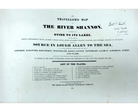
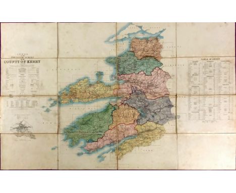
Lot 836
The Shannon in DetailAtlas: Irish Inland Steam Navigation Co.: Grantham (John) surveyor, The Traveller's Map of The River Shannon, arranged as a Guide to its Lakes, ... From its Source in Lough Allan to the Sea, in a course of 239 miles through the Counties of Leitrim, Longford, Roscommon, Westmeath, Kings County, Tipperary & Galway, Limerick, Kerry and Clare. Lg. oblong atlas folio [D.] 1830. Sole Edition, 15 lg. single page maps hd. cold. in outline, title & final map in fine fac-simile, some stains, recent hf. calf marble sides. Good. As an atlas, w.a.f. Ex. Rare. (1)

Lot 837
Co. Waterford: Power (Rev. P.) The Place-Names of Decies, 8vo L. 1907. First Edn., map frontis & other maps, uncut, unopened, orig. mor. backed cloth, gilt spine Celtic decoration. A very good copy; also Mackenzie (Therese Muir) Dromana: The Memoirs of an Irish Family, D. n.d. First Edn., frontis & 13 plts. complete, gilt decor. cloth. (2)

Lot 883
I.A.S.: Hardiman (J.)ed. A Chorographical Description of West or H'Iar Connaught, ... by Roderic O'Flaherty. 4to D. 1846. First Edn.,, map frontis; also O'Donovan (J.)ed. The Tribes and Customs of Hy-Many, Commonly Called O'Kelly's Country. 4to D. 1843. First Edn., map frontis & fold. table, both uniform cloth. (2)


Lot 93
Railway Map: Larcom (Thos. A.) A General Map of Ireland to Accompany the Report of the Railway Commissioners showing the Physical Features and Geological Structure of the Country, A very large engraved folding linen backed map, in 6 parts, approx. 74" high by 60" wide, printed and engraved in Dublin 1837 - 8, with cont. hand colouring, in orig. cloth wrap, and in orig. full leather container, gilt lettered spine, and inscribed in pen by 'Major Hodge, 4th Dragoon Guards,' V. good. (1)* For such a large map, extremely rare in this condition.


Lot 132
BRITISH ISLES, ORTELIUS (ABRAHAM), 'ANGLIAE SCOTIAE HIBERNIAE SIVE BRITANNICAR INSULARUM DESCRIPTIO', a late 16th Century engraved map, hand coloured, with Orientation of North to the right, text verso, unmounted and unframed, hand written number/letter codes to sides, paper size approximately 40.5cm x 55cm, image size approximately 34.5cm x 49.5cm, some staining and slight curl under to right hand side and slight tears, together with two other hand coloured engraved maps of the British Isles including 'Britannia Romana' (3)

Lot 155
STAFFORDSHIRE, BOWEN (EMANUEL), 'An IMPROVED MAP of The COUNTY of STAFFORD Divided into its HUNDREDS, Collected from the best materials and Illustrated with various additional Improvements with Historical Extracts...', with cartouche dedicated to 'The Noble and Right Honorable John Gower Earl Gower', hand coloured, some staining, framed and glazed, approximately 71cm x 54cm

Lot 126
STAFFORDSHIRE, GREENWOOD (C & J), A 'Map of The County of Stafford from an actual survey made in the years 1818 and 1819', published by Greenwood & Co 1830, vignette of Lichfield Cathedral lower right, hand coloured, in card mounts, approximately 57.5cm x 70cm, together with the same map unmounted and a folio of Staffordshire and other UK interest items (2)


Lot 151
WARWICKSHIRE, SPEEDE (JOHN), 'THE COUNTI OF WARWICK THE SHIRE TOWNE AND CITIE OF COVENTRE DESCRIBED, with plans of 'WARWICKE' and 'COVENTREE' and 'THE ARMES OF SUCH HONORABLE FAMYLIES AS HAVE BENE EARLS OF WARWICK', hand coloured engraved map, circa 1630, verso list of hundreds and description of Warwickshire in English, the mount around the text stamped 'THE SEVERN GALLERY' Shrewsbury, glazed back and front and framed, approximately 38cm x 51cm

Lot 140
AMERICA AND EUROPE, ARROWSMITH (AARON), 'MAP OF AMERICA by A. Arrowsmith Hydrographer to H.R.H. The Prince of Wales 1804', paper laid on linen, rolled, lacks wall mount roller, (condition is stained and dirty, some splits in paper including just below pictorial title), overall size 191.5cm x 148cm, image size 119.5cm x 144.5cm and 'MAP OF EUROPE' Drawn from all the Best Surveys and Rectified by ASTRONOMICAL OBSERVATIONS by A. Arrowsmith, Geographer, Rathbone Place, London' and printed inscription 'To The Right Honble SIR JOSEPH BANKS Bart K.B., one of his Majesty's most Honorable Privy Council and PRESIDENT of The ROYAL SOCIETY, This Map is Respectfully Dedicated by His much obliged Humble Servt A. Arrowsmith Hydrographer to H.R.H. The Prince of Wales, Soho Square', hand tinted, paper on linen, rolled, no roller, some staining and tears, overall size 127cm x 148cm, image size 123.5cm x 145cm (2)

Lot 152
STAFFORDSHIRE, BOWEN (EMANUEL), a map from 'The Royal Atlas', 'A Corrected MAP of The COUNTY of STAFFORD divided into HUNDREDS....', hand coloured, framed and glazed, approximately 52cm x 41cm, together with 'STAFFORDIAE COMITATUS PARS Olim Cornauiorum' Kip (William), a hand coloured engraved county map, approximately 27.5cm x 37.5cm (2)

Lot 138
BRITISH ISLES, BLAEU (JOHN) 'INSULAE ALBION et HIBERNIA cum minoribus adjacentibus', a mid 17th Century engraved map, hand coloured, Ptolemaic projection, Spanish text verso, centre fold, stained, crease in margin upper right and upper left, some small tears on left hand edge, paper size approximately 49.4cm x 63cm, image size approximately 38cm x 44.3cm


Lot 131
ENGLAND, SAXTON (CHRISTOPHER) & SPEED (JOHN), 'THE KINGDOME OF ENGLAND', engraved map, uncoloured, eight costume portraits and a catalogue of 'all the shires...', 'To be sold in the Pope's Head Alley by John Sudbury and George Humble', circa 1611, English text verso, paper lower left and right, unmounted and unframed, slight curl on right hand side, paper size approximately 42cm x 53cm and image size approximately 38.5cm x 51cm, together with an unframed bookplate with map of the British Isles titled Britanicae Insulae (2)

Lot 137
BRITISH ISLES, JANSSON (JAN) 'MAGNAE BRITANNIAE et HIBERNIAE Nova DESCRIPTIO', a mid 17th Century engraved map, hand coloured, Royal Coat of Arms upper left, Orkney Isles inset to cartouche upper right, Latin text verso, unmounted and unframed, some staining, paper repair on bottom edge to vertical centre fold, a few tears around margin, some creases in centre and top edge, paper size approximately 49.2cm x 57.7cm, image size approximately 42.5cm x 54.1cm
Lot 158
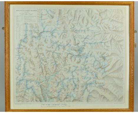
MOUNT EVEREST REGION, a Royal Geographical Society scale 1:100000 colour map, printed by Cook, Hammond & Kell Ltd, circa 1975, titled in the margin 'TREK IN NEPAL 2-22ND MAY 1981 - PARTY LED BY MR A. GREGORY', with route marked in black ink and signed by Alfred Gregory and Suzanne G. Gregory, mounted, framed and glazed, 68cm x 76cm, Alfred Gregory (1913-2010) was a mountaineer, explorer and professional photographer, he was a member of the 1953 British Mount Everest Expedition in charge of stills photography and personally reached 28,000 feet in support of the assault on the summit

Lot 148
BRITISH ISLES, (ANON) BRITANNIA PROUT DIVISA SUIT TEMPORIBUS ANGLO-SAXONUM, PRAESERTIM DURANTE ILLORUM HEPTARCHIA', a hand coloured engraved map, ornate cartouche, fourteen vignettes, Latin text verso, centre crease, some staining and frame contains thrips/thunderbugs, glazed back and front and framed, approximately 42.5cm x 54cm

Lot 153
NOTTINGHAMSHIRE, AFTER MORDEN (ROBERT), a hand coloured reprint, approximately 36cm x 42.5cm, 'A View Accurate and Correct Map of Nottinghamshire, Engraved from an Actual Survey and other Improvements by E. Sudlow', approximately 45cm x 38cm and 'A New Map of The County of Nottingham, Divided into Hundreds', printed for C. Smith, hand coloured, approximately 55cm x 49cm, all three framed and glazed (3)
-
109198 item(s)/page