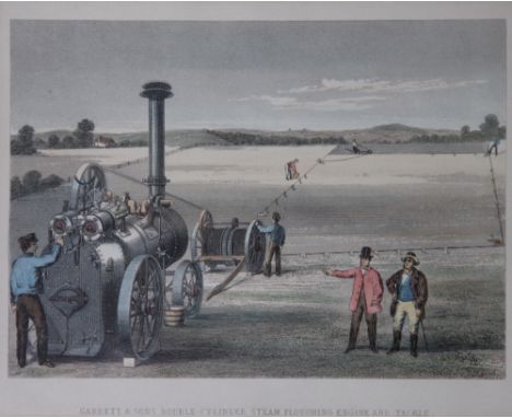
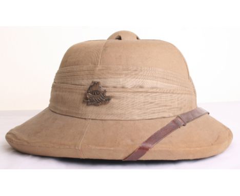
2nd Punjab Regiment Officers Solar Topee Sun Helmet & Insignia, the helmet is of cork body with khaki cloth covering. 14 fold central pagri, fitted with a brass regimental badge to one side and a cloth with tassels. Original brown leather strap. Interior is complete with the original sweatband and liner system. Imperial Hat Works Bangalore tailors label to the inside with J C B Date inked. Helmet is accompanied by a pair of officers slip on rank slides with two crowns and 2 PUNJAB title, and Government Survey Map of India. (4 items)
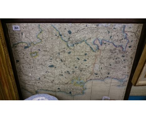
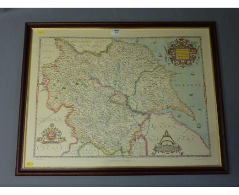
We found 109182 price guide item(s) matching your search
There are 109182 lots that match your search criteria. Subscribe now to get instant access to the full price guide service.
Click here to subscribe- List
- Grid
-
109182 item(s)/page
Speed, John - Hand tinted map of the Isle of Man 1610 The main section showing the Isle of Man surrounded by ships and mythical creatures, with two panels flanked by stating 'described by Thomas Durham Ano 1595', together with the royal coats of arms and the Isle of Man coat of arms, 38x50cm, framed and glazed. (illustrated)
After John Speede - hand coloured engraved map of Devonshire (37cm x 50.5cm) 'DEVONSHIRE WITH EXCESTER DESCRIBED And the Armes of such Nobles as have borne the titles of them...Performed by John Speede And are to be sold by Roger Rea the Elder and younger at ye Golden Crosse in Cornhill against the Exchange', laid down on two book pages from 'Devon-Shire chapter 10 page 19 and 20 and presented in a frame glazed to both sides
After John Speede, hand-coloured map of Herefordshire (39.5cm x 52cm) 'Herefordshire described...Performed by John Speede And are to be solde in the Popes head alley against the Exchange by John Sidbury and Georg Humbell. Cum Privilegio 1610' laid down on two book pages from 'HEREFORD-SHIRE' (pgs 49 and 50 Chap 25.) and presented in a frame glazed to both sides
A set of eight 19th century coloured engravings of ornithological subjects (in two frames) including parrots, bee eaters, humming birds, etc, engraved by S Milne, 71 x 50 cm approx overall, a black and white map of Northumberland after Robert Morden, a set of three coloured studies of Venetian scenes and two black and white engraved portraits of gentlemen
Two signed coloured prints after Lionel Edwards, one showing Belvoir Hunt with old label verso - The Battle of Rutlands (?) Belvoir proof by Lionel Edwards, the other from The Hunting Countries Series showing the South Notts Fox Hounds from Ploughman's Wood, both signed in pencil bottom left, 37 x 51 cm approx both in brown and gilt frames together with further sporting and other pictures and prints including a signed coloured Cries of London print, a needlework sampler by Minnie Truscott, three 19th century ornithological coloured engravings, a 19th century map of Gloucestershire, a Stevengraph needlework picture - The Meet, etc
The Lord of the Rings, by J.R.R. Tolkien. A three volume set of Tolkien's trilogy. This set was not available to the general public, limited to members of the Readers Union only. Published by the Readers Union in 1960 with the permission of George Allen & Unwin Ltd, London. CONDITION REPORT; "The Fellowship of the Ring" book has no dust-jacket. Fold-out map and pages in good order. First page with name written in ink. "The Two Towers" book has its dust jacket, though it is worn with small tears to the edges and discolouration to the folds. Fold-out map and pages in good order. First page with name written in ink. "The Return of the King" book has its dust jacket, though it is worn with small tears to the edges and discolouration to the folds. Fold-out map and pages in good order. First page with name written in ink.
BREVIARE et MISSEL ROMAIN - A l'usage des laiques, Paris 1783, 9cm x 14cm, full contemporary calf with an interesting gilt floral pattern binding; LEMIERRE A. J. - The Hundred Thoughts of a Young Lady, Paris 1802, with French and English text, 16mp, original wraps, frontisplate and coloured map, corners of leaves creased (2)
Willem Blaeu (1572-1638 - A map of Iceland circa 1648 - Latin text - Size approx. 50cm x 38cm - this is a well known map showing Hecla in eruption, the bishopric of Skalholt and to the south the mountains where gyrfalcons came from (falcones albi) Condition report: Minor tears to edge, unmounted, some staining
Heman Moll (1688 - 1745) A set of eight maps of Africa c. 1742 - each approx. 26cm x 18cm - A general map of the whole continent, a map of Zaara or the Desart, The West part of Barbary, the East part of Barbary, Guinea, Loango etc., The South East part of Africa, The South West part of Africa, Abissinia and Anian etc. Condition report: Overall condition good, pencil dates to corners all unmounted
Sir Robert Dudley (1573-1649) A map of the Indian Ocean - uncoloured - Size approx. 48cm x 38cm from Dell'Arcano del Mare circa 1661 - engraved by Antonio Lucini and published in Florence, Dudley was the first Englishman to publish a world sea atlas and the first with all the maps of Mercator's projection Condition report: Unmounted, some spotting, small tear top left, overall good
-
109182 item(s)/page