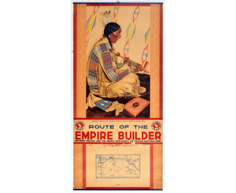

Original vintage travel calendar advertising poster - Route of the Empire Builder Between Chicago and the Pacific Northwest via Glacier National Park - featuring a native American sitting wearing traditional garments with a feather head dress holding a smoking pipe with the caption below - Sundance - Piegan Chief - Glacier National Park Montana. Title text in bold stylised lettering below with a map of Great Northern Railway and connecting lines. Artwork by the German-American portrait artist and graphic designer Winold Reiss (1886-1953) who painted Native American tribal members on the Blackfeet Reservation from 1920. Launched in 1929, The Empire Builder was the flagship passenger train of the Great Northern Railway (1889-1970), originally operating a steam powered service that was re-equipped in 1947 to a streamliner service; it was relaunched in 1971 when it was taken over by Amtrak and now runs daily intercity services between Chicago and Seattle and Portland. Good condition, creasing, tears, staining, metal bars on top and bottom edge, calendar ripped off from poster Country of issue: USA, designer: Winold Reiss, size (cm): 84x40.5, year of printing: 1942
We found 109198 price guide item(s) matching your search
There are 109198 lots that match your search criteria. Subscribe now to get instant access to the full price guide service.
Click here to subscribe- List
- Grid
-
109198 item(s)/page

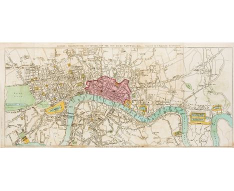
Original vintage folded map of Land's End, a headland and holiday complex in Western Cornwall, UK. Land's End is popularly known for being the most westerly point of mainland Cornwall and England.The coloured map also shows the Lizard, a peninsula in southern Cornwall. This fold out map was published for tourism by the Ordinance Survey, the national mapping agency for Great Britain. The front cover also features an artwork of the iconic St. Michael's Mount, a tidal island in Mount's Bay. The island is a civil parish and is linked to the town of Marazion by a man-made causeway of granite setts, passable between mid-tide and low water. Acceptable condition, stains and scratches on cover, panels backed on old linen from original. Country of issue: UK, designer: Unknown, size (cm): 72x94.5 , year of printing: 1930s

Original vintage travel poster for Dinant issued by Belgian National Railways featuring a great image of a waterside wall with a flag on the tall jagged Bayard Rock in the background. Stylised lettering below next to a map of rail routes between Dinant, Ostend, Brussels, Namur, Amsterdam, Maastricht, Liege, Spa, Tournai, Lille, Charlroi, Paris and Luxembourg. The Bayard Rock, at the entrance of Dinant, is a 35 m high ridge detached from the rest of the cliff. Very good condition, minor tears and minor paper losses at the bottom right. Country of issue: Belgium, designer: P. Nouille, size (cm): 102.5x61.5, year of printing: 1930

Original sport advertising poster of the Olympic torch relay route map at the 1936 Summer Olympic games, held in Berlin. The poster features a map of the route, running from Olympia to Berlin via Athens, Delphi, Thessaloniki, Sofia, Belgrade, Budapest, Vienna, Prague, and Dresden. The graphics feature a hand holding the torch with a burning flame, designed by German sculptor Walter Lemcke. The 1936 Summer Olympics torch relay was the first of its kind, following on from the reintroduction of the Olympic Flame at the 1928 Games. It pioneered the modern convention of moving the flame via a relay system from Greece to the Olympic venue. Leni Riefenstahl filmed the relay for the award-winning but controversial 1938 film Olympia. The map contains small illustrations of sights across the various checkpoints, including the Acropolis, St. Stephen's Cathedral in Vienna, and the Brandenburg Gate. The 1936 Summer Olympics (German: Olympische Sommerspiele 1936), officially known as the Games of the XI Olympiad (German: Spiele der XI. Olympiade), were an international multi-sport event held from 1 to 16 August 1936 in Berlin, Germany. Berlin won the bid to host the Games over Barcelona at the 29th IOC Session on 26 April 1931. The 1936 Games marked the second and most recent time the International Olympic Committee gathered to vote in a city that was bidding to host those Games. Hitler saw the 1936 Games as an opportunity to promote his government and ideals of racial supremacy and antisemitism, and the official Nazi party paper, the Völkischer Beobachter, wrote in the strongest terms that Jews should not be allowed to participate in the Games. In a blow to the NSDAP theories, Jesse Owens of the United States won four gold medals in the sprint and long jump events, and became the most successful athlete to compete in Berlin, while Germany was the most successful country overall with 89 medals total, with the United States coming in second with 56 medals. Good condition, foxing, tears, staining. Country of issue: Germany, designer: Unknown, size (cm): 101x63.5, year of printing: 1936

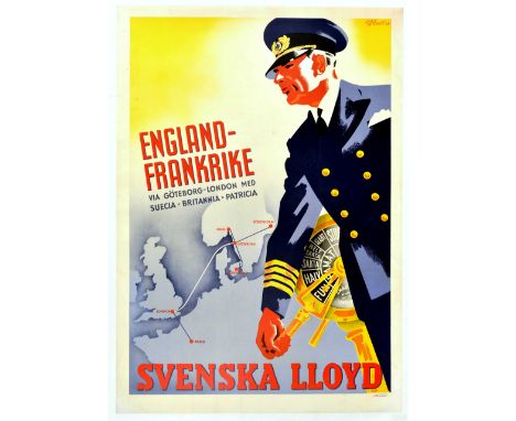
Original vintage cruise travel poster advertising Swedish Lloyd / Svenska Lloyd - England Frankrike via Goteborg London Med Suecia Britannia Patricia - featuring great artwork of a captain in a smart blue uniform and hat with his hand on the engine order telegraph turned to full steam ahead powering the ship to the destinations marked on the map in the background showing the shipping route lines between Gothenburg, Oslo, Stockholm, Copenhagen, London and Paris. Printed in Sweden by Nezata. The Svenska Lloyd shipping company was founded in the Swedish sea port of Gothenburg in 1869; the company was taken over by the Brostrom Group in 1977. Very good condition, restored tears. minor staining, backed on linen. Country of issue: Sweden, designer: G.G. Bratt, size (cm): 100x70, year of printing: 1937

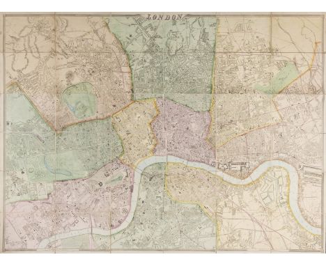
Original vintage folded map of a Children's Map of London, printed and published by John Bartholomew & Son Ltd of Edinburgh. Collins Bartholomew, formerly John Bartholomew and Son, is a long-established map publishing company originally based in Edinburgh, Scotland. It is currently a subsidiary of HarperCollins. Asides from the main landmarks of central London, the coloured map contains other drawings and illustrations that include Gog and Magog on either side, two legendary monstrous giants often associated with London. At the bottom of the map, it is marked that 'All author's royalties on this plan are being given to The Hospital for Sick Children, Great Ormond Street, London'. Good condition, pinholes and stains around pinholes at margins, few minor tears along the folds, backed on original muslin. Country of issue: UK, designer: Unknown, size (cm): 56x75.5, year of printing: 1938

Original vintage folded map of Bacon's Cycling Road Map - 50 Miles Round London. Publlished by G.W. Bacon & Co. Ltd, 127 Strand, London. George Washington Bacon (1830–1922) was an American mapmaker and publisher who developed a successful business producing maps of London, and started his his business on the Strand in 1870. Acceptable condition, slight browning of paper, minor creasing and tears on cover page, small tears at fold intersections, original hand drawn county boundaries, map marked with red pen. Country of issue: UK, designer: Unknown, size (cm): 58.5x80, year of printing: 1900s

Original travel advertising poster for the East Asiatic Company, for passenger passenger ship services serving between Europe and Asia - covering the Straits (modern day Singapore and Malaysia), Siam (Thailand), and Ceylon (Sri Lanka). The East Asiatic Company was founded by Hans Niels Andersen, a Danish shipping magnate and businessman in Copenhagen in 1897. Service which would eventually include both passenger and freight lines between the Danish capital, Bangkok and the far east was the initial objective. Routes to include the Baltic and Black Seas were established when in 1899, the subsidiary Russian East Asiatic Steamship Co. of St. Petersburg was formed. The artwork features a large passenger ship and a globe against a bright orange background, with the globe showing the a map of the route between Denmark and the East. Very good condition, crease marks. Country of issue: Denmark, designer: Bille, size (cm): 94.5x62, year of printing: 1950s

Original vintage Travel by British Railways poster for Lincoln featuring a bright and colourful design by the artist and pictorial map designer Kerry Lee (1902-1988) of the historic cathedral city of Lincoln in England depicting trees around the gothic Lincoln Cathedral (built 1185-1311) over the city's medieval town and 11th century Norman castle with boats on the River Witham by the timber framed buildings on the stone High Bridge (built c.1160), the bold title text below with the mischievous Lincoln Imp gargoyle (this now mythical symbol of Lincoln can be seen set in stone in the Cathedral) against the yellow border. Published by British Railways (Eastern Region) PP1200. Printed by R.B. Macmillan Ltd Derby. Good condition, restored folds, restored paper losses, restored pinholes, backed on linen. Country of issue: UK, designer: Kerry Lee, size (cm): 100x63, year of printing: 1950s
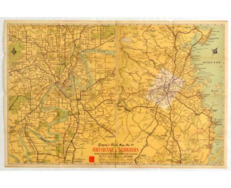
Original vintage folded map of Brisbane city, Australia and its suburbs, as No. 77 of the series 'Gregory's Road Map', and officially recognised by the Royal Automobile Club of Queensland. Brisbane River can be seen - it is the longest river in South-East Queensland, Australia, and flows through the city of Brisbane, before emptying into Moreton Bay on the Coral Sea. John Oxley, the first European to explore the river, named it after the Governor of New South Wales, Sir Thomas Brisbane in 1823. The penal colony of Moreton Bay later adopted the same name, eventually becoming the present city of Brisbane. Good condition, minor tears at folds, minor foxing mainly on cover page. Country of issue: Australia, designer: Clive Barrass, size (cm): 49.5x75, year of printing: 1950s

Original vintage cruise travel poster - Lloyd Triestino MV. Africa MV. Europa Italy South Africa Express - featuring a dynamic design against a red background showing a map of Europe and Africa highlighting Italy and the eastern coastline of Africa hanging from a traditional style African spear with a rocket shape at the tip, a sleek cruise liner sailing above a leopard skin style fold, the bold white lettering above and in black below with the ships named on the side. The modern streamlined MV Africa and Europa were launched in 1951 to operate Lloyd Triestino's Italy Africa route from 1952; the Africa sailed her maiden voyage from Genoa to Cape Town and the Europa sailed her first journey from Trieste to Cape Town; both were sold in 1976. Battistella. Printed in Italy. La Editoriale Libraria SpA Trieste. Good condition, repaired tear, minor creasing, small paper loss in margins. Country of issue: Italy, designer: Battistella, size (cm): 68x48, year of printing: 1950s

Original vintage British Rail poster for Richmond Yorkshire See Britain By Train featuring a scenic painting by Edward Wesson(1910-1983) of the historic Norman keep and walls of Richmond Castle surrounded by trees above buildings in the market town of Richmond and the old stone bridge over the River Swale with a box below showing the train route on a map of Great Britain marking Edinburgh Newcastle Darlington Richmond York London with the British Rail logo North Eastern Region and stylised information text reading: An ancient market town with a fine 11th century castle standing high on a rock above the River Swale. Richmond is the ideal centre for exploring Swaledale and is reached by moder diesel trains from the East Coast Main Line at Darlington. Good condition, minor creasing, small tears, foxing, small paper loss. Country of issue: UK, designer: Edward Wesson, size (cm): 101.5x63.5, year of printing: 1962

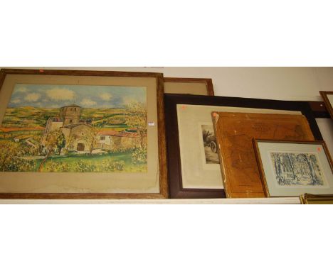
Bartholomew's revised half inch contoured folding linen backed maps of Great Britain, including Ayrshire, Dartmoor, Harris and the Lews, Sussex, and Vale of Severn, Ordnance survey one inch maps of England and Wales, various editions, Luton, Perranporth, Plymouth, etc, Ordnance survey map of England and Wales large sheet series South London, all folding and linen backed, Bartholomew's revised half inch to a mile motorists and cyclists map, sheet 23 Wye Valley, and similar south Devon two miles to an inch, other one inch ordnance survey maps, etc (9)

Bartholomew's Reduced Ordnance Survey four miles to the inch folding linen backed map plan of Edinburgh, ordnance survey map of inner London, G.W Bacon & Co folding linen backed map of England and Wales, Cruchley's county maps of England for cyclists, tourists etc, Gloucester, BR Southern Regions central division timetable, etc in one box

1975 Ossa MAR, 244 cc. Registration number JCE 57N. Frame number B222922. Engine number M222922. In a bid to emulate the competition successes of rivals Bultaco and Montesa, Ossa hired English trials star Mick Andrews in 1967. Then only 23 but already a proven winner, Andrews set about developing Ossa's existing trail bike into a competitive trials mount, Andrews became the Monarch of the Glens in the 1970 Scottish, a process that culminated in the MAR - Mick Andrews Replica - that carried its creator to consecutive European Trials Championships in 1971 and '72. The MAR put Ossa on the trials map with a vengeance and proved so successful that it remained in production until the late 1970s. This UK bike was first registered in June 1975 and it was used by a marshal at various events to get himself in position (see decals on the body). By 1982 it was with father and son, Brian and Peter Moore of Cambridge, they rebuilt the engine with new piston rings. Followed by a more comprehensive restoration in 1988, there is an MOT on file for 1,320 miles in 1993. Our vendor bought it in 2007 and stored it in a dry garage. Recently recommissioned it would be advisable for the next custodian to undertake their own safety checks before entering this competitive machine into competition. Sold with the V5, old MOT, various receipts, workshop manual and brochure.

1975 Ossa Explorer, 250 cc. Registration number JGM 196N. Frame number B333295. Engine number M333295. Spain's Ossa factory had a relatively brief existence from 1951 to 1984, but in that time produced outstandingly successful competition models for racing as well as enduro and road machines. In a bid to emulate the competition successes of rivals Bultaco and Montesa, Ossa hired English trials star Mick Andrews in 1967. Then only 23 but already a proven winner, Andrews set about developing Ossa's existing trail bike into a competitive trials mount, a process that culminated in the MAR - Mick Andrews Replica - that carried its creator to consecutive European Trials Championships in 1971 and '72. Indeed, the MAR put Ossa on the trials map with a vengeance and proved so successful that it remained in production until the late 1970s. In 1972, OSSA released the Explorer ? a great name for the kind of riding the bike would be subjected to. The intent was to have a light bike that was easy to ride, something between an enduro and a trials bike. This example, first registered on July 1975, is a UK bike, and in 1991 was owned by Patrick Neill of Wokingham who sold it to Kevin Hookey of Bordon in 1998. In 2005 he commenced a restoration of the machine which included an engine rebuild, together with the frame and body being repainted. It was MOT'd at 707 km and taxed that year. Our vendor bought it from in in 2007 and stored it in a dry garage. The mileage is now 809 km. Recently lightly recommissioned it would be advised for the next custodian to undertake their own safety tests before hitting the trial again. Sold with the V5C, 2005 MOT, tax disc and various receipts.


Michelin Tyres Tin Map Sign Make: Contact AuctioneerModel: Contact AuctioneerYear: 0Mileage: 0VIN: Contact AuctioneerConfiguration: Right Hand DriveRegistration: Contact AucitoneerTransmission: Contact AuctioneerVintage Michelin Map Metal Sign 64 x 87 cm's This lot is subject to a buyers premium of 15% plus VAT


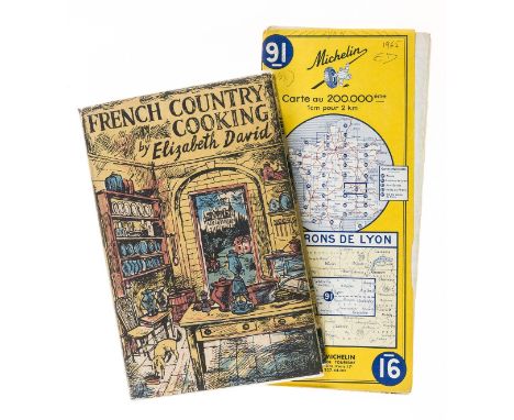
David (Elizabeth) French Country Cooking, first edition, frontispiece, vignette title, illustrations, occasional faint spotting, original cloth, very slight bumping to spine extremities, dust-jacket, slight creasing to top edge, 1951; and Elizabeth David's Michelin map of Lyon, with her initials to upper corner, 8vo (2)
![[Rosini (Carlo Maria)] Dissertationis Isagogicae ad Herculanensium voluminum explanationem, Pars Prima [all published], title](https://cdn.globalauctionplatform.com/e57fc01d-4601-4a97-bb27-ac5d00c4a35e/cfada3fd-9eb9-4b42-a9de-ac5d010d1dea/468x382.jpg)
[Rosini (Carlo Maria)] Dissertationis Isagogicae ad Herculanensium voluminum explanationem, Pars Prima [all published], title with woodcut floral ornament, 2 folding engraved maps and 20 engraved plates, 2 folding, some foxing to text, first map with tears to folds, old boards, rebacked in red morocco, spine gilt in compartments, t.e.g., others uncut, folio, Naples, ex Regia Typographia, 1797.
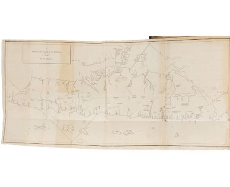
Indonesia.- Marsden (William) The History of Sumatra, containing an Account of the Government, Laws, Customs, and Manners of the Native Inhabitants ..., first edition, folding engraved map frontispiece, tear, expertly repaired, 1 plate, previous owner's ink inscription to title and front pastedown, occasional marginal spotting and staining, contemporary calf, rebacked, a little rubbed, slight bumping to corners, 4to, 1783.

Pamphlets.- Peterloo Massacre, parts 1-12 only (of 14), folding engraved map frontispiece, lacking title, pp.1-2 trimmed at head, not affecting text, Manchester, J. Wroe, [1819], bound before The Eleventh Conspiracy of the Oligarchy of England, and their Anglo-Irish Agents, against the Life of O'Connor, Defeated, previous owner's ink signature to title, Dublin, 1817, occasional spotting, contemporary calf backed boards, rebacked, rubbed, together 2 vol. bound as 1, 8vo. ⁂ The second pamphlet is scarce, not listed on Library Hub.
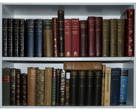
Napoleon Bonaparte.- De Bourrienne (M.) Memoirs of Napoleon Bonaparte, 4 vol., engraved portrait frontispiece, plates, folding plan, spotting and occasional browning, contemporary half calf, extremities a little rubbed but overall an attractive set, 1836 § Forsyth (William) History of The Captivity of Napoleon at St. Helena..., 3 vol., frontispieces, folding map to vol.1, some spotting and occasional finger-soiling, frontispiece to vol.2 laid down, original blind-stamped cloth, spines faded, 1853; and 31 others relating to Napoleon and St Helena, v.s. (38)

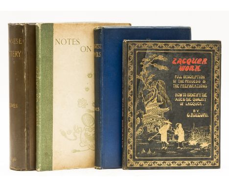
Japan.- Bowes (James L.) Japanese Pottery, first edition, ALs by author loosely inserted, 16 plates, 1 folding map, illustrations, cracked hinges, original cloth, rubbed joints, bumping to corners and extremities, Liverpool, 1890; Japanese Enamels, first edition, colour frontispiece and 19 plates (1 colour), illustrations, original cloth, a little rubbed, slight bumping to corners and extremities, Liverpool, 1884; Notes on Shippo: a sequel to Japanese Enamels, first edition, 3 plates, illustrations, faint spotting to first and last few leaves, original cloth-backed boards, a little rubbed, slight bumping to corners and extremities, 1895; and another, similar, 4to (4)
![Milne (A. A.) [The Christopher Robin Books], 4 vol., comprising, The House at Pooh Corner, small loss to spine extremities, f](https://cdn.globalauctionplatform.com/e57fc01d-4601-4a97-bb27-ac5d00c4a35e/813102fb-a6cc-436c-9d23-ac5d010dd163/468x382.jpg)
Milne (A. A.) [The Christopher Robin Books], 4 vol., comprising, The House at Pooh Corner, small loss to spine extremities, first edition, 1928; Winnie the Pooh, seventh edition, loss to spine extremities, lacking backstrip, 1928; When We Were Very Young, 1928; Now We Are Six, fourth edition, lacking majority of backstrip, 1928, illustrations by E. H. Shepard, map and pictorial endpapers, original publisher's roan, rubbed, 8vo.⁂ These 4 volumes were published to celebrate the publication of 'The House at Pooh Corner', the fourth and final book in the Winnie the Pooh series.
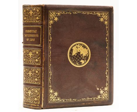
Japan.- Morton-Cameron (W. H.) Present Day Impressions of Japan, first edition, decorative title, portrait frontispieces, photographic plates and illustrations (some colour), folding colour map, short marginal tear with no loss (p.921), original decorative calf, gilt, cracked joints, slight bumping to corners and extremities, large 4to, 1919.
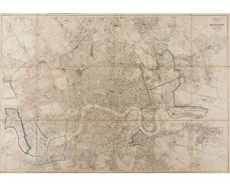
London.- Kelly's Directories Ltd (High Holborn-based publisher) Metropolitan Conference. Map of Collection & Delivery Boundaries for Goods Traffic, large folding map showing from Tottenham to Ilford, and Peckham to Willesden, lithograph with outline hand-colouring, 1000 x 1625 mm (29 1/2 x 63 3/4 in), dissected and mounted on linen, some surface dirt and minor handling creases, blue paper endpapers, folding into red cloth boards, lacking cloth ties, worn, 4to, 1904.
London.- Wakefield (Priscilla) Perambulations in London, and its environs, first edition, folding hand-coloured engraved map, 4 engraved plates, occasional faint off-setting, contemporary calf, spine foot restored, a little rubbed, slight bumping to spine head, Darton and Harvey, 1809 § Lester (T.) Illustrations of London, engraved title only and 64 plates, occasional spotting, later half-morocco, a little rubbed, 1818, 8vo (2)
London.- Weller (Edward) London, large folding map on a scale of 9 1/2" to the mile, engraving with hand-colouring, 1430 x 1955 mm (56 1/4 x 77 in), dissected and mounted on linen, some surface dirt, nicks and scuffs, folding with purple endpapers, contemporary slip-case with gilt title to upper cover 'Cassell's Map of London', worn, 4to, Peter Cassell, [1863].
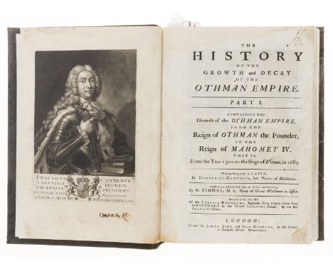
Turkey.- Cantemir (Demetrius) The History of the Growth and Decay of the Othman Empire, 2 parts in 1 vol., first English edition, translated by N. Tindal, mezzotint portrait frontispiece, small ink inscription to margin, 22 engraved plates, some with marginal tears, neatly restored, folding engraved map, browned lower edge, strengthened on verso, 47 leaves of text provided in facsimile, occasional spotting, faint marginal dampstaining to first few leaves, trimmed, modern calf, folio, for James, John, and Paul Knapton, 1734; sold not subject to return
Africa.- Burton (Sir Richard Francis) First Footsteps in East Africa, 2 vol., the "Memorial edition", 1894; Vikram and the Vampire, 1893; A Mission to Gelele, King of Dahome, one vol. only (of 2), 1893, the first with 4 colour lithograph plates and map, others with plain plates, half-titles, bookplates to pastedown, original pictorial cloth, gilt, vol. 2 of first very lightly marked, else an excellent set, 8vo (4)
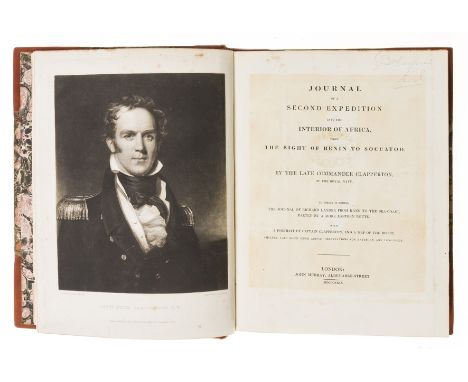
Africa.- Clapperton (R.H.) Journal of a Second Expedition into the Interior of Africa, first edition, engraved mezzotint portrait frontispiece, engraved folding map and plan, small repairs to map, lacking half title, title browned, occasional light spotting or offsetting, endpapers foxed, 20th century half calf, rebacked and recornered preserving contemporary marbled boards, rubbed, morocco spine label, gilt, 4to, 1829.
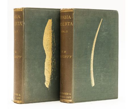
Middle East.- Doughty (Charles M.) Travels in Arabia Deserta, 2 vol., David Garnett's copy, second edition, half-titles, photogravure portrait, plates and plans, some folding, folding linen-backed colour map in pocket at end of vol.1, illustrations, original pictorial cloth, gilt, t.e.g., others uncut, spines faded and lightly rubbed, head and foot chipped, 8vo, 1921.⁂ Copy of David Garnett, a prominent member of the Bloomsbury group who co-founded the Nonesuch Press with Francis Meynell.
Thailand.- Bowring (Sir John) The Kingdom and People of Siam, 2 vol., one folding map, 2 facsimile letters, 15 chromolithographed or engraved plates only (of 16), lacking half-titles, some light foxing, short tear to plate in vol.1 not affecting the image, contemporary half morocco, worn, upper cover to vol.1 detached, 8vo, 1857.
World.- Froissart (Sir John) Chronicles of England, France, Spain, and the Adjoining Countries, 2 vol., additional hand-coloured title, illustrations, bookplates to pastedown, 20th century ink ownership signature to half-title, some light spotting to first few ff., contemporary calf, spines gilt, rebacked preserving original spine strip, lightly rubbed, 1842 § Du Chaillu (Paul) Adventures in The Great Forest of Equatorial Africa, additional wood-engraving bound at front with presentation inscription from the author beneath, frontispiece, map and illustrations, later pictorial half morocco, gilt, 1890; and 5 others, travel and topography, 8vo & 12mo (8)
Britain.- Cary (John) Cary's New Map of England and Wales with part of Scotland, engraved title, hand-coloured general map and 76 sheets (numbered 1-81), mostly engraved maps hand-coloured in outline but including dedication, key and scale as part of sheets, no sheets numbered 62, 71 or 80, ?as issued, list of subscribers, occasional faint spotting and off-setting, bookplate, later half-morocco, rubbed, slight bumping to corners and extremities, 4to, 1794.
NO RESERVE Britain.- Lambarde (William) A Perambulation of Kent: Conteining the Description, Hystorie, and Customes of That Shire, third edition, lacking engraved map, title and first two ff., first few ff. rather browned, some damp staining and soiling, 20th century calf-backed boards, by R. Hodgkinsonne, for D. Pakeman, [1656] § Boswell (James) The Journal of a Tour to the Hebrides, with Samuel Johnson..., third edition, some spotting to half-title and title, 20th century half calf, by Henry Baldwin, 1786; and c.80 others, British topography, v.s. (c.80)

Curated by Quentin Tarantino himself, the Once Upon a Time in Hollywood Original Motion Picture Soundtrack features over 20 standout tracks from artists such as Paul Revere & The Raiders, Deep Purple and Neil Diamond. The sealed two-disc soundtrack is presented in a gatefold sleeve with the records printed on Tequila Sunrise (orange) 220-gram vinyl. Completing this impressive set is six matching numbered posters (#182/1,500), including four faux Rick Dalton film posters (11" x 17"); a Hollywood Map (11" x 17") and Steve Chorney's "Once Upon a Time in Hollywood" One-Sheet artwork (24" x 36").5 x posters 11" x 17" (28 x 43 cm); large poster 24" x 36" (61 x 91.5 cm); LP 12.5" x 12.5 " (31.5 x 31.5 cm)Condition: Very Good (Posters), Excellent (LP Record)Album - Excellent condition (Still sealed, unplayed). The smaller posters all have a crease to the bottom right edge (from shipping) with the larger cinema style poster in excellent rolled (as issued) condition.Artist: Steven Chorney£100 - 200VAT Status: M
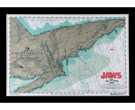
Released as a timed limited edition print in September 2019. The artist Anthony Petrie in collaboration with Bottleneck Gallery and Vice Press worked directly with Steven Spielberg and Amblin Entertainment to come up with an officially licensed movie poster variant based on Petrie’s original 2015 ‘Chum Chart’ design. The new version offers a different take on the classic image, as Amity Island (the setting for the movie) is reimagined as a map in the shape of a Great White Shark. Clever and very effective. This limited edition art print is number 635 of 1,530. Printed on a heavy stock paper this looks and presents near perfectly.24" x 36" (61 x 91.5 cm)Additional Information: Hand-Numbered #635/1530Condition: ExcellentUnrestored, rolled, flat and unfolded (as issued). Very minimal handling wear. It presents and displays to excellent effect.Artist: Anthony Petrie£100 - 200VAT Status: M
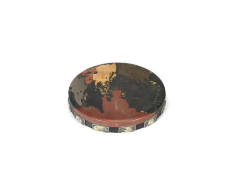
An unusual, inlaid, and lacquered-wood circular suzuribako (box for writing utensils)By a member of the Nomura family, Edo period (1615-1868), 18th/19th centuryThe inrobuta (flush-fitting lid) embellished in gold and iro-e hiramaki-e with an old map of the world, annotated in katakana and Chinese characters, the inside of the lid lacquered in gold hiramaki-e and applied with two ceramic clams from one of which issues forth Chinese figures in intricate and exotic landscape scenes representing the Shinkiro ('Clam's Dream'), the inside of the box with a fitted round board, black-lacquered with a wave-patterned ground containing a removable oval suzuri (ink-grinding stone) and a silver suiteki (water-dropper) in the form of a crescent moon, the side of the box applied with the junishi (12 animals of the East Asian zodiac) carved in relief in pale-olive and white pottery, each within a rectangular reserve on a lacquered ground of turbulent waters; signed on the underside of the box Nomura Kigo/Sonoato sei. 3.3cm x 23.1cm (1¼in x 9 1/16in). (4).Footnotes:The large red land mass located at the bottom of the world map on the lid is identified as the hypothetical continent of Terra Australis ('South Land' in Latin), sometimes also called Australia or Magellanica (the 'Land of Magellan'), among other names. While not yet discovered, it was presumed to exist as it was believed there should be a land mass in the southern hemisphere to balance that in the northern hemisphere. It was depicted in maps between the fifteenth and eighteenth centuries.The label of the continent on the lid is from a Chinese transliteration of Magellanica.For further information on this lot please visit Bonhams.com


-
109198 item(s)/page