We found 108737 price guide item(s) matching your search
There are 108737 lots that match your search criteria. Subscribe now to get instant access to the full price guide service.
Click here to subscribe- List
- Grid
-
108737 item(s)/page


Lot 241
London General Omnibus Company MAP & GUIDE TO OMNIBUS SERVICES dated September 1912, from the second year of issue of the classic London bus map which ran from March 1911 until 1994. Features an illustration of the famous B-type bus on the cover. In reasonable condition, commensurate with age with some seam tears. [1]


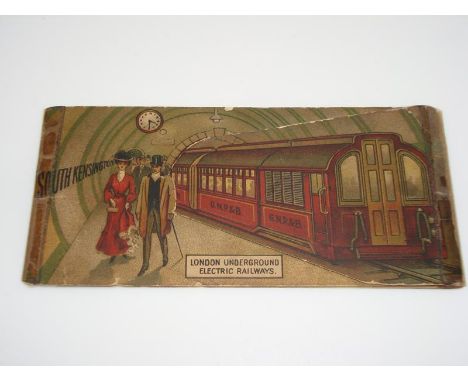
Lot 257
London Underground Electric Railways 1907 advertising CARD with MAP, one of a series featuring different stations, in this case South Kensington with an illustration of a Great Northern, Piccadilly and Brompton Railway train. The card opens into 3 parts by lifting the train to reveal more of the station, including posters. It opens out to show fares, journey times and season-ticket rates. The reverse of the card has a small map of the Underground. Fair condition., some old tape repairs [1]

Lot 195
London Underground 1922 ''MAP of the Electric Railways of London - What to see and How to travel''. Edition dated 1-3-22. Designed by MacDonald Gill, this attractive map uses his own calligraphy for the station names and key box and features a decorative border. Apart from a trace of adhesive on the spine on the reverse, and a tear to the fold on one panel, this example is in very good condition.


Lot 184
First edition of the London Underground diagrammatic, fold-out CARD MAP designed by Harry Beck and issued in January 1933 with the famous inscription ''A new design for an old map....''. This is a superb example: crisp,firm and almost certainly unused, with just a little age-darkening of the card.


Lot 260
1890 District Railway ''COUNTRY MAP OF THE ENVIRONS OF LONDON'', the 2nd edition of a series which ran from 1883 to 1898. Pocket-sized, paper map inside card cover with the various counties in different background colours and showing the DR connections with the Metropolitan and main-line railways, reaching to St Albans in the north and Dorking in the south. A couple of corner partings, and slight damage to interior of spine, but overall a very good copy of this scarce issue. [1]


Lot 240
London General Omnibus Company MAP & GUIDE TO OMNIBUS SERVICES dated July 1912, from the second year of issue of the classic London bus map which ran from March 1911 until 1994. Features an illustration of the famous B-type bus on the cover. In reasonable condition, commensurate with age with some seam tears. [1]


-
108737 item(s)/page