We found 109182 price guide item(s) matching your search

Refine your search

Year

Filter by Price Range
  • List
  • Grid
  • 109182 item(s)
    /page

Lot 322

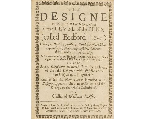
Fens Drainage.- Dodson (Col. William) The Designe for the perfect Draining of the Great Level of the Fens, (called Bedford Level)...as it was delivered to the Honourable Corporation for the Drainage of the said Great Level, the 4th of June, 1664..., first edition, title with typographical border, woodcut initials, folding engraved map, lacking initial blank, a little browned, one or two stains, cropped, later half calf, spine chipped at head, [Wing D1801], small 4to, by R. Wood...so be sold by Henry Twiford...and by Rich. Marriott, 1665.⁂ Rare, with only 8 UK copies listed by ESTC (BL, 2 in Cambridge, 2 in Oxford, Petyt Library, Senate House Library and Sheffield University) and 2 locations in America (Folger and Harvard). The only auction record we have been able to find was the Kenney copy in 1965 (£50).

Lot 424

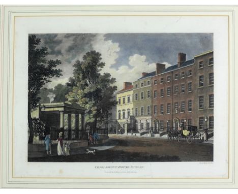
Fine Collection of Georgian Views of Dublin Malton (James) A Picturesque and Descriptive View of the City of Dublin, a fine set of 27 (26 hand coloured acquaints) each approx. 45cms x 58cms (17 3/4" x 23") including the Map and Coat of Arms of the City of Dublin, published London (J. Malton & G. Cowen) Dublin July 1794 & 1795, in matching hogarth frames. (27) Provenance: Property of a Titled Lady.

Lot 424A

Irish Map: Blaeu (William) Hibernia Regnum Vulgo - Ireland, c.1660 ptd. on paper, contemporary hd. colouring, Dutch text verso, framed. (1)

Lot 506

An antiquarian hand-coloured map of Northumberland, after Speed (1646), 52cm by 42cm, together with another 19th century hand-coloured map of Northumberland. (2)

Lot 653

A mid 20th century brass bound map top coffee table, length 117cm.

Lot 493

Map: Irish [Lodge (John)] The Course of the Grand Canal from Dublin to the River Shannon, c. 1850, approx. 14cms x 40cms (5 1/2" x 15 1/2"), framed. (1)Provenance: The Odlum Family, Spire Hill, Portarlington, Co. Laois

Lot 111

A Greenwood & Co. map of the County of Monmouth, hand-coloured, engraved Josiah Neele, published 1831, 63 x 75cm, unframed, three other maps of Monmouthshire and a hand-coloured map of Herefordshire by H Moll, 21 x 32cm, framed, (5).

Lot 492a

Collection of Suffolk related paintings, to include Jill Squire, River Alde, Iken, Suffolk Summer, Elizabeth Gravener Suffolk Marshes near Snape, E. Purcell Cavendish, a reproduction map of Essex and two other paintings, (8)

Lot 594

Two maps of Oxfordshire by Creighton & Kitchin, two maps of England & Wales, map of Yorkshire, map of Berkshire by J. & C. Walker, map of Kent by J. & C. Walker, (7)

Lot 202

A frame and glazed map of Suffolk engraved from an actual survey with improvements

Lot 247

BRITISH SCHOOL (19th CENTURY) PENCIL DRAWING Study of a boy's head Bearing signature 'Geo Romney', Abbot Hall Art Gallery, Kendal exhibition label verso 5 1/4" x 4 1/2" (13.5 x 11.5cm) ALSO A FOLDED LINEN-BACKED MAP OF THE COUNTY OF LEICESTER by C. Smith, published 1801 17 1/2" x 19 1/2" (44.5 x 49.5cm) borderline AND A LATE VICTORIAN OVAL POTTYER DISH (3)

Lot 382

EARLY NINETEENTH CENTURY HAND COLOURED MAP OF OLDHAM With vignette 'Market Place from the West' and numbered 'Reference' 6" x 9 ½" (15.2cm x 24.1cm) THREE BOOKPLATE ENGRAVINGS, Edinburgh and Glasgow Framed and glazed, (4)

Lot 108

An early 19th century map, linen-backed by Phillips of Southern England

Lot 106

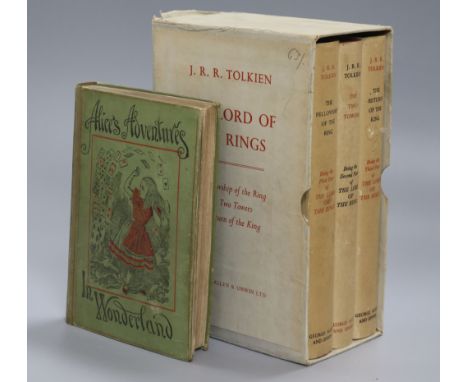
J. R. R. Tolkien, The Lord of the Rings, 3 vols, George Allen & Unwin, London, comprising The Fellowship of the Ring, 13th impression, 1963, The Two Towers and The Return of the King, each 9th impression, 1962, all with folding map, crimson boards and non price-clipped dust jackets, original slip case (some discolouration to spines but otherwise good); together with Lewis Carroll, Alice's Adventures in Wonderland (People's Edition), seventy-eighth thousand, 1898, pictorial green cloth (4)

Lot 110

Horsfield, Thomas - The History and Antiquities of Lewes, 2 vols, quarto, with folding frontis map and 37 litho plates, Lewes 1824-27

Lot 111

Hoskins, George Alexander - Travels in Ethiopa, quarto, cloth, with folding map (foxed), and 49 (of 54) litho plates (2 hand coloured and 4 chromolithos, front cover detached, spine ragged, some plates loose, lacking front fly leaf, London 1835

Lot 186

An early Vulgate New Testament, missing titlepage, starting at page 3 with 'Sanctum Jesu Christi Evangelium Secundum Matthaeum Caput I...' and decorated capital 'L' (Liber generationis...), later-bound with a folding map of the Holy Lands (three maps in one) after Nicolas Sanson (1600-1667), the arms of Edward [9th] Duke of Norfolk, Earl Marshall of England (1686-1777) pasted down on inside front board (covering a previous ink inscription) and an engraving of Ezekiel and the Angel to inside back board, gilt-tooled calf, small 32mo

Lot 319

Richard Brome, a hand-coloured map of Kent, 1670 and Robert Morden, a hand-coloured map of Sussex (2)

Lot 146

A vintage map rule for Eastern Telegraph co

Lot 552

DESCRIPTIVE MAP OF LONDON POVERTY 1989, South- Western sheet, comprising the Parish of Chelsea and parts of Fulham, Kensington, St George's Hanover Square, Strand, Lambeth and the Battersea portion of Wandsworth, 52cm x 63cm, framed and glazed.

Lot 697

1914 FRENCH MAP OF EUROPE 'Les Nationalites au XIX siecle', 100cm x 143cm.

Lot 2090

A quantity of Prints to include a Pears style Print 'Secret', a Map of Wales, 'By the Water lnae' by Myles B. Foster, etc

Lot 244

Large white painted metal map case containing various maps and scale plans including township of Coxwold, various indentures paperwork etc relating to rent - William Lancaster of Mardervy Grange etc

Lot 383

Original 17th Century c1690 copper plate road map from Carlisle to Berwick Upon Tweed. By John Ogilby from Britannia. Measures 19x59cm frame size.

Lot 20

HUMPHREY LLWYD coloured and tinted late sixteenth century antiquarian map - 'Cambriae Typus' being the earliest recorded map of Wales shown as a separate country, circa 44 x 55cms, glazed to rearcondition:There are two one inch tears along the bottom edge otherwise everything looks good

Lot 21

THOMAS KITCHEN coloured antiquarian map - two counties of 'Cardiganshire' and 'Pembrokeshire' from The Large English Atlas, circa 1760, with coloured boundaries and a view of Haverfordwest, 74 x 57cms

Lot 25

EMANUEL BOWEN coloured antiquarian map - 'Six Counties of North Wales...' with views of Bangor and St Asaph Cathedrals, circa 1750, unframed, 40 x 50cms

Lot 26

UNKNOWN GEOGRAPHER coloured antiquarian map - 'Denbigh and Flintshire', 20.5 x 31.5cms

Lot 163

Antique map 'Moravia' the Murray Firth, 42 x 56cm

Lot 552

A 19th century hand coloured map of The Bristol Channel, with inscription 'To The Right Honourable Sir Robert Southwell, who attended his Majesty King William the 3rd in this Expedition for Ireland in Quality of Principall, Secretary of State for that Kingdom', 48cm x 59.5cm, and a double engraving of a Perspective View of the City of Bath and the City of Bristol, engraved for Walpoole's New Complete British Traveller, 34cm x 21.5cm

Lot 1024

A copy of a Map of Wales by Jean Bleau, 17" x 21" together with a copy of Gordon's Map of South Wales Coalfield

Lot 1082

A framed Alexander the Great Map, Alexandria Magni, Macdomis Expedition

Lot 1136

A quantity of vintage Postcards, a Harding's Map of Llanelly, a vintage Chesterman of Sheffield tape measure and a Victorian writing box (as found)

Lot 1216

An old map of Herefordshire by Robert Morden, hand coloured.

Lot 125

A Second World War 26th Hussars / Chindit campaign medal group, that of Y7942712 L/Cpl Allan Smith, B Squadron, XXVI Hussars, including Pay Book and Permanent Pass, a quantity of Airgraphs and postcards, an album and loose photographs, an embroidered "ditty" bag, two Chindit formation signs and a shoulder title, silk escape map, and a number of post-War items including veterans' association badges, beret, photographs and ephemera

Lot 165

An album of photographic negatives, some positive prints and a "Russia in Europe" map pertaining to the 1919 British Military Mission to Siberia, together with related research

Lot 75

C M L Bouch, Prelates and People of the Lake Counties, A History of the Diocese of Carlisle 1133-1933, Kendal, Titus Wilson, 1948, 514pp, illus, map, signed copy, quarter gilt calf with blue cloth boards

Lot 534

An 18th Century hand coloured map of CheshireHand coloured, published by Cadell & Davies, 26x36cm.

Lot 538

A birds eye coloured map of the city of Antwerp, late 18th/early 19th CenturyMap copy of the original map from 1500's, 45x78cm, framed and glazed.

Lot 192

Collectables to include Edwardian silver cased travel pencil, engraved foliate scroll decoration, makers Francis Webb, Birmingham 1909, horn handled pen knife, the Universal Map Measurer cased, enamelled medallion for The Royal Albert Asylum etc

Lot 45

A PAIR OF ENAMEL AUSTRALIAN MAP & BOOMERANG CUFFLINKS, LATE 19TH CENTURY each comprising one circular face decorated with blue enamel, depicting Australia split into its states, connected by chain to a boomerang link.

Lot 103

Entomology: A Collection of Birdwing Butterflies, circa mid 20th century, a large framed case containing six specimens of male Birdwing butterflies to include - Ornithoptera Goliath, Victoriae, Paradisea, Meridionalis, Tithonus and Rothschildi, set against a background map of New Guinea & Indonesia, enclosed within a pine glazed case 53cm by 6cm by 53cm, a pair of Ornithoptera Paradisea Arfakensis, displayed and mounted on a background map of Australia & South-West Pacific, contained within a stained Watkins & Doncaster Deal glazed wall case, 40cm by 5cm by 30cm, a pair of Ornithoptera Tithonus, contained within a stained Watkins & Doncaster Deal glazed wall case, 25cm by 5cm by 40cm, all specimens with data tags (3)
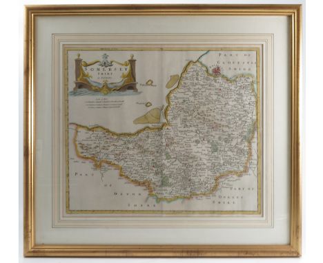
Lot 49

A map of Hertfordshire printed by John Bill, from The Abridgment of Camdens Britannia c1626, 4" x 5"

Lot 50

A Pieter Van Den Keere map of Hertfordshire from Miniature Speed Edition 1627, 3 1/2" x 5"

Lot 51

A Bowen map of Hertfordshire c1720, 7" x 5"

Lot 1005

An RAC celluloid map of England and Wales and the Lowlands of Scotland, 17 3/4 x 23 3/4".

Lot 1211

An Firestone Tyres Geographia Main Roads map of England and Wales enamel sign, 28 3/4 x 48".

Lot 1550

An Esso painted hardboard counter top road map dispenser with assorted early Esso maps.

Lot 1802

A Vehicle Testing Station sign and a Michelin map sign.

Lot 372

Philip & Tacey Ltd cut-out map of England & Wales, boxed and Europe, boxed, 32cm x 24.5cm Condition:

Lot 66

Early to mid 20th Century hand embroidered map of the British Isles, possibly World War II era with Royal Arms, various motifs including rose, daffodil etc on blue background, 63cm x 44.5cm Condition:

Lot 122

Christopher Saxton, antique coloured map of Flint, 11ins x 12.5ins

Lot 126

Robert Morden, Antique hand coloured map of Gloucestershire, sold by Abel Swale, Awnsham and John Churchill, 13.5ins x 16.5ins, together with a Robert Morden, Antique hand coloured map of Somerset, 14ins x 16.25ins and a John Ogilby Antique hand coloured road map, Bristoll to Worcester

Lot 127

An Antique hand coloured map, The Severn or Channell of Bristoll, with text and shipping scene, 17ins x 22ins

Lot 389

250 years of map making in the county of Sussex 1575-1825, introduction by R A Skelton and edited by Harry Margory, in blue folio with cardboard outer

Lot 1437

Wartime Interest. A First edition May 1944 of ''Medical Administrative Instructions'' issued by Air Command South East Asia to a Flight Sergeant Smart. There are many hand written notes, an illustration or two and a map. A very interesting collection of wartime medical instructions.

Lot 339

[MAPS] Morden, Robert (c.1650-1703), 'Somerset', engraved county map, hand-coloured in outline, 37cm x 43cm, framed and glazed.

Lot 340

[MAPS] Morden, Robert (c.1650-1703), 'Cornwall', engraved county map, hand-coloured in outline, 35.5m x 41.5cm, framed and glazed.

Lot 178

A large lot including film photographs and photograph albums together with stereoscopic viewer cards, prints, map, walking stick, miniatures, books etc

Lot 541

PHOTOGRAPH ALBUM, period wooden album decorated with map of Japan and floral border, contains 16 unidentified private snapshots (probably taken in Japan), G to VG

Loading...Loading...
  • 109182 item(s)
    /page

Recently Viewed Lots