We found 109182 price guide item(s) matching your search
There are 109182 lots that match your search criteria. Subscribe now to get instant access to the full price guide service.
Click here to subscribe- List
- Grid
-
109182 item(s)/page


Lot 1634
An early map of Paris, VTETIA, commonly known as Paris, is the great Gaul, watered by the navigable river Sequana, a noble wind, a merchant, and the most excellent of the temples of B. Marie, Palario Regio, of stupendous work, and other than the most magnificent buildings, the tribunal of the most famous judges, and the most beautiful bishops. Dimensions 63x48.5cm postage category D


Lot 867
Framed antique black and white map of the North Western hemisphere, 35 x 48cm, gilt framed, together with four other various small framed mapsThere is a centre crease/fold line and text can be seen from print on reverse. It's not stuck down and only small amount of margins are visible. There is a photo copy on reverse of text which may possibly be on the reverse of map if removed from frame.


Lot 524
Two Japanese woodblock printed maps of JapanEdo periodComprising of Bansei Oedo ezu (or Bansei on Edo ezu), showing main temples and shrines pictorially, published by Fujiya Kichizō and Yamashiroya Masakichi, dated 1849; Dai Nihon hayami dōchūki, designed by Tomonari Shokyoku, original edition published by Mikawaya Tetsugorō of Edo; both framed and glazed, 80 x 91cm; 35 x 133.5cm map only, including margins. (2) Condition Report: PLEASE NOTE THIS LOT HAS NOT BEEN EXAMINED OUT OF THE FRAME.Square frame: Fraying to the marks created by folding of the map, dirt, and discolouration to print, wear to the gilt frame. Manufacturing fault result in the minor flaw to the alignment to the centre of the print.Rectangular frame: Fraying to the marks created by folding of the map, dirt, discolouration, foxing and watermarks to the print. Wear to the wood frame with damage to the top corners.


Lot 804
Map, Persici vel Sopho Rum Regni Typus, map of Persia with cartouch 'Persici vel sopho rum regni typus', Gerard Mercator and Jodocus Hondius, Amsterdam 1623, text to verso titled 'The Description of the Kingdome of Persian' from the "Gerardi Mercatoris Atlas sive Cosmographicae" (Mercator-Hondius Atlas), engraving 50cm x 35cm, paper 57cm x 48cm The central theme of this map centers on the ancient Kingdom of Persia, even though it prominently displays the contemporary territories of Iraq, Iran, and Afghanistan. Notably, the map highlights key cities such as Bagadet (Baghdad), Chabul or Cabul (Kabul), which is situated to the south rather than the north of Candahar (Kandahar), and various other towns and cities. This map offers a fascinating glimpse into how Western observers perceived the geography of the interior during the early 1600s.

Lot 144
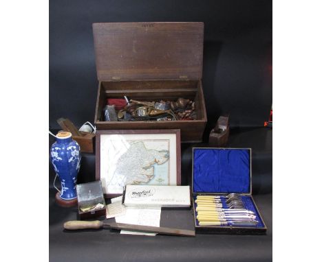
A miscellaneous collection to include a Victorian meat plate, a 19th century Meissen style porcelain figure or a character holding a lantern with hand painted floral jacket, striped trousers, etc, 19th century continental figure of a cello player, Georgian decanter, Robert Morden map of Wiltshire, etc


Lot 241
A fascinating trench or situation map detailing the allied advance from the 30th July to 5th October. The map also notes the capture of 255,012 German troop from July to Sept. The position of the old frontline is printed. The ever moving new frontline is hand drawn in ink. Torn and fragile and in need of restoration. H.49 W.58cm.


Lot 360
The lot comprising of etchings of various country houses: Shipton Court; Burford Priory; Chastleton; Broughton Castle; and Minster Lovell Priory. Together with two small hand-coloured etchings of children at play; a watercolour of fishermen by a mill; a hand-coloured etching of Mahon Harbour; and a hand-coloured engraved map of Menorca.In various conditions. The frame of Shipton Court is cracked.


Lot 290
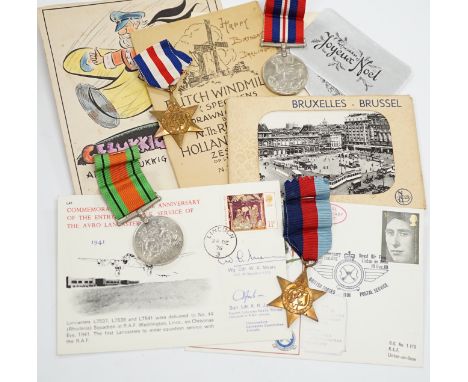
An RAF silver mug, and framed drawing of a map of Belgium and surrounding countries relating to 83rd Group Main HQ, Tactical Air Force 1944-45 together with four WWII medals in the original card, issue box; the Defence Medal, the War Medal, the France and Germany Star, and the 1939-1945 Star, postcards, and other items


Lot 74
20th Century Continental School, etching, A harbour view, possibly Port of Valletta, Malta, signed to the lower right, framed, mounted, and under glass, measuring 14cm x 17cm, & 22cm x 27cm overall, together with three other pictures, to comprise a hand coloured map of Westmorland, Cumbria, a gouache painting of a fashionable lady, and a sketch of mice on toadstools (4)

Lot 21
Beautiful single volume from Hetzel's French edition Aux Feuilles d'Acanthe, Macaron Rouge, from Les Mondes Connus et Inconnus by writer Jules Verne. It includes the novel De la Terre a La Lune (From the Earth to the Moon) with 41 illustrations and one map by De Montaut. Collection Hetzel, Bibliotheque d'Education et de Recreation, published by Pierre Jules Hetzel et Cie, Paris. Artist: Jules Verne (French 1828-1905)Issued: 1906-1910Dimensions: 7.25"W x 10.75"H x 0.75"DManufacturer: HetzelCountry of Origin: FranceCondition: Very good. Minor tear on lower part of spine.

Lot 25
Beautiful single volume from Hetzel's French edition Aux Feuilles d'Acanthe, Macaron Rouge, from Les Mondes Connus et Inconnus by writer Jules Verne. It includes the novels L'Etoile du Sud (The Vanished Diamond, or The Southern Star) with 60 illustrations and one map by Benett. Collection Hetzel, Bibliotheque d'Education et de Recreation, published by Pierre Jules Hetzel et Cie, Paris. Artist: Jules Verne (French 1828-1905)Issued: 1906-1910Dimensions: 7.25"W x 10.75"H x 0.75"DManufacturer: HetzelCountry of Origin: FranceCondition: Very good.

Lot 105
A Boer War Period Imperial Map of Griquatown, South Africa compiled for Field Intelligence Department, Cape Town, March 1900, measuring 60 x 49 cm, linen folded in stiff linen cover. Area around Griquatown and Douglas, and the confluence of the Vaal and Orange Rivers. With light brown foxing overall.


Lot 85
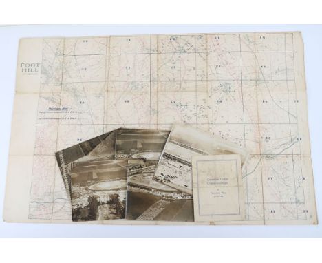
Capt. Edgar Shamper, No.5 Squadron, Royal Flying Corps, Canadian Corps Championships original aerial photos, five (c. 22cm x 18cm) of the Canadian Corps Championships/Sports Day at Tinques, near Arras, France on 1st July 1918, taken by Capt. Edgar Shamper, No.5 Squadron, Royal Flying Corps, with an interview transcript of his widow Vera (nee Carter). One photo explains in his own hand how he dropped the prints to Gen. Currie while the games continued, with an original well-used Corps Championships programme; Shamper’s Trench Map of ‘Foot Hill’ including Bailleul, scale 1:20,000, showing trenches corrected to 19.6.1918.
Lot 97
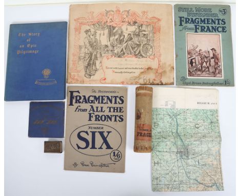
Great War Curios, consisting of memorial scroll to Serjt. RJ Wright, London Regt. (371042, Post Office Rifles), in original transmission tube. Official map of the Ypres Front, scale 1:40,000, September 1917. Travel Ticket for the British Legion Battlefields Pilgrimage, August 1928 and book ‘The Story of an Epic Pilgrimage’, 1927 Menin Gate Matchbox Holder. Bairnsfather ‘Fragments from France No.3’ and ‘Fragments from all the Fronts No. 6’ in fair condition. (7 items)

Lot 144
Original vintage map poster issued by the Vehicle and General Insurance Group - 1000 Miles Trial for Veteran Cars which ran from 1-9 May 1970. Good condition, creasing, pinholes, tears, staining, small paper loss on left margin. Country of issue: UK, designer: Unknown, size (cm): 77x52, year of printing: 1970.

Lot 205
Original antique travel map - City of London 1677 by John Ogilby. G. Philip & Son 32 Fleet Street London - with charts and atlases. A Large and Accurate Map of the City of London. Ichnographically Describing all the Streets, Lanes, Alleys, Courts, Yards, Churches, Halls and Houses & c. Actually Surveyed and Delineated. By John Ogilby Efq; His Majesties Cofmographer. Fair condition, folds, staining, creasing, tears, backed on old linen. Cover has creasing, tears, staining, paper losses. Country of issue: UK, designer: John Ogilby, size (cm): Folded 23.5x15 Folded 56x92, year of printing: 1677.

Lot 206
Original antique travel map - Cary's Actual Survey on the Country Fifteen Miles round London. On a Scale of one Inch to a Mile. Wherein the Roads, Rivers, Woods and Commons; as well as Every Market Town, Village. Printed for J Cary, Engraver, Mal & Print feller. Fair condition, tears, folds, small paper losses, staining, backed on old linen. Cover sleeve in poor condition, staining, tears, creasing, paper skimming, paper losses. Country of issue: UK, designer: Unknown, size (cm): 19x16 folded. 75x88 Unfolded., year of printing: 1786.

Lot 207
Original antique travel map - London Drawn & Engraved expressly for the Post Office Directory 1885. Good condition, folds, tears, browning, minor staining, tears, small paper losses, paper skimming, backed on old linen. Cover has tears, creasing, ripped sticker Country of issue: UK, designer: Unknown, size (cm): Folded 21x15. Unfolded 73x94 , year of printing: 1885.
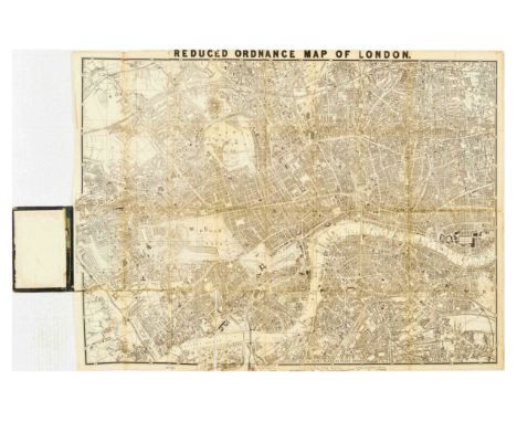
Lot 208
Original antique travel poster - Churchley's Reduced Ordnance map of London with 4000 street references and what to see. One shilling. Churchley 81, Fleet Street. - with a detailed map of London. Fair condition, cover has creasing, paper losses, tears staining. Map has folds, tears, paper losses, staining, creasing. Country of issue: UK, designer: Unknown, size (cm): Folded 18x11 Unfolded 67x87, year of printing: 1870s.
Lot 210
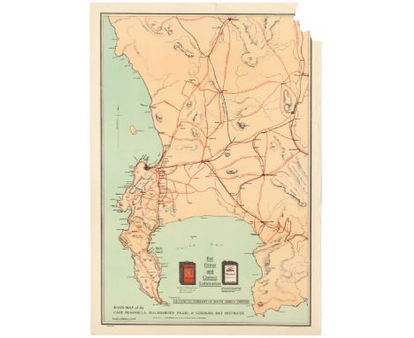
Original vintage Road map of the Cape Peninsula, Malmesbury, Paarl & Gordons Bay Districts. Drawn by A.I Bannerman from the best available sources of information. Presented by the Vacuum oil company of South Africa Limited. Adverts for Pegasus motor spirit and Mobiloil. Fair condition, tears, creasing. Vacuum Oil Company was an American oil company known for its Gargoyle 600-W Steam Cylinder Oil. Vacuum Oil merged with the Standard Oil Co of New York, commonly known as Socony Oil to form Socony-Vacuum Oil Company, and is now a part of ExxonMobil. County: South Africa, year of printing:1920s, designer: A I Bannerman, size (cm): 70x49. Poor condition,tears and loss on margins.

Lot 218
Original vintage Art Deco travel poster advertising Draguignan as a centre of tourism being equal distance from the sea and mountains showing a map of France featuring Cannes, St Tropez and the Alps, Les Gorges du Verdon. Designed by E. Desous. Inscribed PAL at the lower bottom. Great image of a car driving towards the map. Printed by Societe Nationale des Chemins de Fer Francais. Inscription at the bottom Venez en Dracenie...et vous serez charmes. Very good condition, tears, bumps on margins. The French Riviera (known in French as the Côte d'Azur, Occitan: Còsta d'Azur) is the Mediterranean coastline of the southeast corner of France. There is no official boundary, but it is usually considered to extend from Cassis or Toulon on the west to the France–Italy border in the east, where the Italian Riviera joins. The coast is entirely within the Provence-Alpes-Côte d'Azur (PACA) region of France. The principality of Monaco is a semi-enclave within the region, surrounded on three sides by France and fronting the Mediterranean. County: France, year of printing:1930s, designer: Desous P.A.L., size (cm): 100x61.5cm.
Lot 221
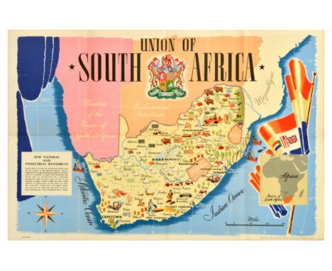
Original vintage illustrated map poster for the Union of South Africa Her Natural and Industrial Resources featuring colourful images of the main cities including Cape Town, Pretoria and Johannesburg with the various produce, factories and agriculture in each region such as gold, fruit, asbestos, sheep farming marked for wool, diamonds, grapes for wine, textiles, fishing, rivers, fields and cattle with boats along the coast at sea by the Atlantic Ocean and Indian Ocean labelled in stylised lettering, an image of a larger map of Africa marking South Africa in front of the Union flag of South Africa framing the right side and a blue curtain framing the left side above the compass point and information box, the coat of arms in the centre with the bold title above. Published by Thos Forman and Sons of Nottingham. Horizontal. Very good condition, folds as issued, minor staining. Country of issue: UK, designer: Unknown, size (cm): 51x76, year of printing: 1940s.
Lot 223
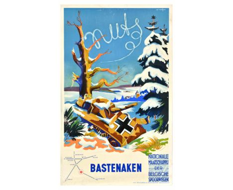
Original vintage post-WWII railway travel poster for Nationale Maatschappij der Belgische Spoorwegen / Belgian National Railway Company. Colourful illustration of a discarded German Nazi tank covered in snow in a trench by a war-torn tree with a snow-topped tree on the side, village and hills in the distance, and a route map below marking Bastogne Anvers Ostende Brussels Namur Liege Cologne Paris and Luxembourg next to the SNCF Belges train track logo. Artwork by the painter Pol Francois Mathieu (1895-1979). Printed by Cocu & Mairesse, Quaregnon. Good condition, creasing, tears, staining, pinholes, small paper losses on edges. Country of issue: Belgium, designer: Pol Mathieu, size (cm): 100x62, year of printing: 1947.

Lot 225
Original vintage poster showing an illustrated map of Holy Land, issued by the National Savings Movement for use in schools. The illustrations are based on Old and New Testament. The National Savings Movement was a British mass savings movement that operated between 1916 and 1978 and was used to finance the deficit of government spending over tax revenues. Excellent condition, light fold marks. Country:UK, Year:1950, Designer:Mahoney, Size (cm):101x75.5
Lot 232
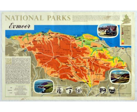
Original vintage travel poster featuring an annotated map of Exmoor National Park featuring travel routes, roads, railways, youth hostels, place names, camping areas, golf courses, fishing location, horse riding and sailing areas. More detailed illustrations and descriptions surround the main map. Exmoor is loosely defined as an area of hilly open moorland in west Somerset and north Devon in South West England. It is named after the River Exe, the source of which is situated in the centre of the area, two miles north-west of Simonsbath. Horizontal. Printed in England by her Majestys Stationary Office press, Manor Farm. Good condition, folds, creasing, tears, pinholes, staining. Country of issue: UK, designer: Unknown, size (cm): 49.5x75, year of printing: 1965.
-
109182 item(s)/page