We found 109198 price guide item(s) matching your search
There are 109198 lots that match your search criteria. Subscribe now to get instant access to the full price guide service.
Click here to subscribe- List
- Grid
-
109198 item(s)/page


Lot 410
John Speed (1552-1629). 'DORSETSHYRE', a hand-coloured engraved map, with a plan of Dorchester, together with 'SOMERSET_SHIRE' a hand-coloured engraved map, with a plan of Bath, text to verso, both dated '1610', 37.7 x 50cm and 39.2 x 52cm, both framed and glazed. (2)Click here to view the online page turning catalogue.


Lot 216
A John Ogilby 18th Century road map, Bristol to Exeter, later coloured, 35 cm x 45 cm together with another John Ogilby road map, Oxford to Bristol, 33 cm x 44 cm and two other county mapsThe maps appear to have been printed in the 18th century and then coloured by hand during a later period in history.

Lot 650
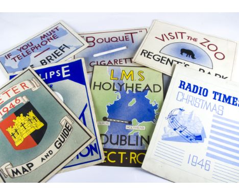
Ephemera, Art work, a small collection of 1940's original art work inc, Decorative Art 1943-1948 cover page, L.M.S. Dublin to Hollyhead poster,Bouquet Cigarettes, Telephone poster, Regents park Zoo,Eclipse Illumination, Vehicle names, Radio Times 1946, and exeter 1946 Map and Guide cover, all named "Keith Lewis". Parcel


Lot 102
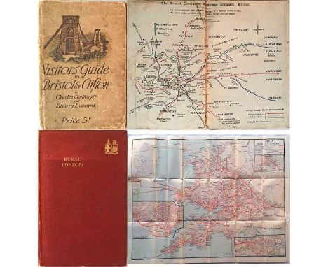
c1910 Visitor's GUIDE to Bristol & Clifton with coloured map of Bristol Tramways and many photos, incl cars & charabancs (heavily used and a little fragile) plus 1924 Great Western Railway GUIDEBOOK 'Rural London' with two fold-out maps of the GWR local services and their full network (lightly-used, good condition). [2]

Lot 108
c1915 Metropolitan Railway POCKET MAP of the Underground system titled 'The Met'. Carries the UndergrounD logo on the map side and shows the Met lines in brown and others in blue. Opens out to 17" x 13.5" (43cm x 34cm) and has print-code 1320/16M. In used condition but generally a very reasonable copy of this rarely-seen map. A few roads in west London have been coloured in with blue pencil.

Lot 128
c1879 District Railway MAP, "The Improved 'District Railway' Map of London". Appears to be the 4th known variant of the 1st edition and shows the DR open to Richmond and Ealing with the Hounslow branch and the Inner Circle Completion and Eastern Extension to Whitechapel as 'proposed'. Map is mounted and framed behind acrylic. Some creasing and wear apparent but presents well. Measures 46" x 31" (117cm x 78cm) overall. [1]
![1907 "District" [Railway] MAP of Greater London & Environs, 2nd edition. Shows the Franco-British Exhibition (held in 1908) a](https://cdn.globalauctionplatform.com/7ad708ff-fdd7-4eb3-8fec-a88200dfbabb/8efc8c66-0341-40f1-aaf0-a8f9012b6dd2/468x382.jpg)
Lot 14
1907 "District" [Railway] MAP of Greater London & Environs, 2nd edition. Shows the Franco-British Exhibition (held in 1908) and Exhibition Station on the CLR. A large-scale, full-colour, paper map (42" x 26", 107cm x 66cm), folded into thin-card covers. Bakerloo, Hampstead & Piccadilly tubes shown in bold, non-Group tubes, eg Central and C&SLR, not so prominently! Fragile at the folds and has parted from the covers at the corner panel. [1]

Lot 150A
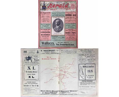
1908 Huddersfield Herald Official Illustrated TRAM GUIDE & MAP for week commencing July 6th. A 6-page publication with a Huddersfield tram system map in the centre-fold, a list of routes, details of events and period advertisements. A little larger than A4 size and generally in very good condition. A most fascinating and unusual item. [1]
Lot 151
First-year H C Beck London Underground DIAGRAMMATIC CARD MAP. The undated edition with no print-code, issued c. August 1933. Refers to re-naming of Dover St station to Green Park and the merger of Holborn and British Museum stations. A few small foxing spots but in other respects a very good example. [1]
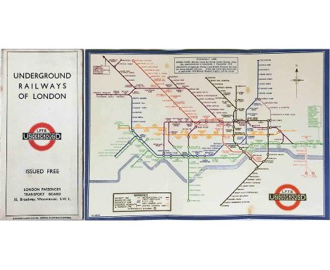
Lot 155
1924 London Underground MAP of the Electric Railways of London "What to see and how to travel". Designed by MacDonald Gill with his distinctive style of calligraphy and map border, this is the issue dated 5/4/24 and has the British Empire Exhibition stations overprinting. An excellent copy with only the most minor of blemishes. [1]
![1907 "District" [Railway] MAP of Greater London & Environs, 2nd edition. Shows the Franco-British Exhibition (held in 1908) a](https://cdn.globalauctionplatform.com/7ad708ff-fdd7-4eb3-8fec-a88200dfbabb/f983cd0c-3e17-45cd-bef8-a8f901341f6f/468x382.jpg)
Lot 158
1907 "District" [Railway] MAP of Greater London & Environs, 2nd edition. Shows the Franco-British Exhibition (held in 1908) and Exhibition Station on the CLR. A large-scale, full-colour map (42" x 26", 107cm x 66cm), linen-backed and folded into hard covers. Bakerloo, Hampstead & Piccadilly tubes shown in bold, non-Group tubes, eg Central and C&SLR, not so prominently! In very good condition, better than usual for these. [1]

Lot 166
1905 London County Council, River Steamboat Service MAP OF THE RIVER THAMES 'shewing the Steamboat Piers...'. Also shows Railways, Tramways, Tramways Authorised, Underground Railways and Railways Authorised. Inside soft covers, map folds out to 24" x 15" (61cm x 38cm). Map is generally in good condition, cover is worn & fragile with a repair to the spine. Plus 2 x Great Western Railway (GWR) River Thames SHEET MAPS, the first c1906 with some Underground connections (edge stains from tape on reverse)) and the second c1920 (vgc). [3]

Lot 17
c1928/9 London Underground linen-card POCKET MAP from the Stingemore-designed series of 1925-32. This is one of the two first issues of the larger, second series and is the one with the yellow cover. These were issued before any of the line extensions were projected. Lightly used with a small crease and slight staining to the back cover but generally a very good copy. [1]
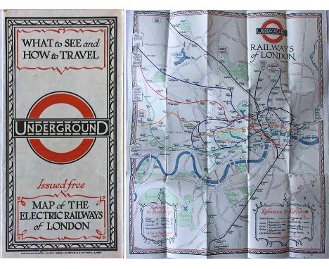
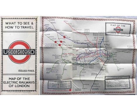
Lot 172
1928 London Underground MAP of the Electric Railways of London "What to see and how to travel". December (12/1928) edition designed by E G Perman with elaborate calligraphy of station names and border etc. In very good condition apart from foxing marks on the rear cover which show through on that panel of the map. [1]

Lot 183
c1928/9 London Underground linen-card POCKET MAP from the Stingemore-designed series of 1925-32. This is one of the two first issues of the larger, second series and is the one with the yellow cover. These were issued before any of the line extensions were projected. A few foxing spots and Colindale station has been highlighted but otherwise a very good copy. [1]

Lot 187
1924 Metropolitan Railway POCKET MAP, the Met's own version of the London Underground map. This is the edition with print-code G.1608.100,000 and is the version with the overprint on the map for the British Empire Exhibition and Cup Final Stadium. An unusually good example in excellent condition, crisp and firm, with minor blemishes only. [1]


Lot 191
Quantity of paper issues of the London Underground DIAGRAMMATIC MAP comprising 11 copies of a c1959 issue by H C Beck, a c1961 issue by Harold C Hutchison and a c1966 issue by Paul E Garbutt. All are single-sided , the same size as the card pocket maps and are in excellent, unused condition. [13]
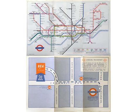
Lot 192
Special edition, c1965, of the London Underground POCKET DIAGRAMMATIC MAP, a paper version produced for distribution to arriving passengers at the British European Airways (BEA) West London Air Terminal in Cromwell Road with walking directions to Gloucester Road station. A most unusual item. In excellent condition. [1]

Lot 194
Special c1962 edition of the London Underground card POCKET DIAGRAMMATIC MAP produced for the Rank Organisation. Cover and reverse has details of Top Rank theatres, bowling, dancing, restaurants, health clubs etc. Undated but has 'July 1962' written in pencil on cover and the map shows the settled post-war network before construction of the Victoria Line. In excellent condition. [1]

Lot 195
London Transport ANNUAL REPORTS for 1938 x 2, 1939 and 1946. The 1938 issues contain the fold-out map of the LPTB New Works Programme 1935-1940 covering the Underground proposals and remaining tram-to-trolleybus conversions, including the south London network. One of the 1938 issues has loose covers, otherwise all are in good, used condition. [4]
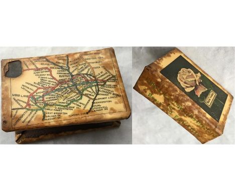
Lot 21
c1908 tin-plate MATCHBOX HOLDER featuring an UNDERGROUND MAP on one side similar to the style used by Johnson, Riddle on contemporary official pocket maps. Produced for King's Acre Nurseries, Hereford and shows a Marie Verdier rose on the reverse. Well used with some stains and a small area of damage. A most unusual item. [1]

Lot 210
1950s/60s POSTER MAP of Western National & Southern National, 'Proprietors of Royal Blue Express Services', bus and coach routes in the South Devon & East Cornwall Area. Illustrated at the edges with pictures of the towns served. Measures 30" x 20" (76cm x 51cm) and generally in very good condition. Folded. [1]
-
109198 item(s)/page