We found 109182 price guide item(s) matching your search

Refine your search

Year

Filter by Price Range
  • List
  • Grid
  • 109182 item(s)
    /page

Lot 110

Corry, John. The History of Bristol, Civil and Ecclesiastical, 2 volumes, first edition, 12 engraved plates, spotted and browned, half-title to volume 2 only, modern morocco-backed boards, 8vo, Bristol: W. Sheppard, 1816; Evans, John. A Chronological Outline of the History of Bristol, and the Stranger's Guide through its Streets and Neighbourhood, first edition, folding engraved map, torn along fold and partly detached, spotting, contemporary half morocco, 8vo, Bristol: Privately Printed, 1824 (2)

Lot 124

Richardson, William. The Monastic Ruins of Yorkshire, 2 volumes, first edition, 2 tinted lithograph title-pages, lithographed dedication, 55 full-page lithographed plates and 26 half-page, guards, hand-coloured map, heavily spotted, some staining, contemporary half morocco, worn, boards detached, folio, York: Robert Sunter, 1843, sold w.a.f.

Lot 125

Rudder, Samuel. A New History of Gloucestershire, first edition, 6 engraved plates only, double-page engraved map, cropped and laid-down, title repaired, contemporary mottled calf, worn, rebacked, folio, Cirencester, 1779, sold w.a.f.

Lot 127

Scarth, H. M. Aque Solis, or Notices of Roman Bath, 52 lithographed plates, folding map, folding plan, light spotting, modern library buckram, ex-library copy, stamped, 4to London: Simpkin and Marshall, 1864; and 10 others similar, Bath interest, v.s. (11)

Lot 129

Smith, Alfred Charles. Guide to the British and Roman Antiquities of the North Wiltshire Downs in a Hundred Square Miles Round Abury, second edition, 7 full-page plates, double-page index map and 19 mounted maps, most double-page, light browning, modern cloth, ex-library copy, with stamps, most to reverse of maps, folio, [Devizes: The Wiltshire Archaeological and Natural History Society], 1885

Lot 137

Beattie, William. The Waldenses or Protestant Valleys of Piedmont, Dauphiny, and the Ban de la Roche, engraved additional title, engraved portrait frontispiece, 70 engraved plates, folding engraved map, spotted, contemporary full morocco, heavily rubbed, joints slightly cracked, all edges gilt, 4to, London: George Virtue, 1838

Lot 139

Belzoni, Giovanni Bastista. Narrative of the Operations and Recent Discoveries within the Pyramids, Temples, Tombs, and Excavations in Egypt and Nubia, 2 volumes, third edition, half-titles, lithographed portrait frontispiece, lithographed plate, folding map, folding plan, some spotting, contemporary mottled calf, rubbed, 8vo, London: John Murray, 1822; Plates Illustrative of the Researches and Operations of G. Belzoni in Egypt and Nubia, 39 [of 44] lithographed views on 32 leaves, 34 hand-coloured, 2 folding, leaf of descriptive text, folio, London: John Murray, 1820, bound with; Six New Plates Illustrative of the Researches and Operations of G. Belzoni in Egypt and Nubia, 6 hand-coloured lithographed plates, 4 folding, some creased, folio, London: John Murray, 1822, contemporary half calf, worn, boards detached (3) RARE. The folio lacks views nos. 4, 5, 27, 41 and 42.

Lot 144

Conder, Claude Reignier. The Survey of Eastern Palestine. Memoirs of the Topography, Orography, Hydrography, Archaeology, etc., volume one [all published], first edition, plates, illustrations in text, folding map in pocket at front, original cloth gilt, 4to, London: Committee of the Palestine Exploration Fund, 1889

Lot 147

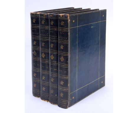
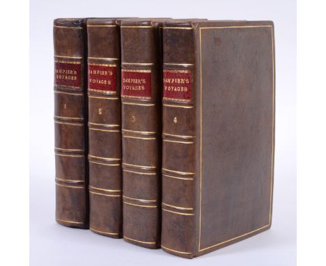
Dampier, William. A Collection of Voyages, 4 volumes, 63 engraved plates, maps and charts, including 21 folding, 'A Map of the World' coloured by hand with fore-edge repaired, Fff4 in volume 2 with rust-mark, not affecting text, a few plates creased, light browning and spotting, modern full antique calf gilt, dentelles gilt, bookplate of Charles Frederic Wood, 8vo, London: James and John Knapton, 1729 A FINE COPY. The works this collection are as follows: Volume 1. William Dampier, A New Voyage Round the World, seventh edition, 4pp. of advertisements at end, 1729; Volume 2. Pt. 1. William Dampier, A Supplement to the Voyage Round the World, 1729; Pt. 2. Two Voyages to Campeachy, 1729; Pt. 3. A Discourse of Trade-Winds, Breezes, etc., 1729; Volume 3. Pts 1-2. A Voyage to New-Holland, &c., In the Year 1699, third edition, 1729; Pt. 3. Lionel Wafer, A New Voyage and Description of the Isthumus of America, third edition, 1729; Volume 4. Pt. 1. William Funnell, A Voyage Round the World, 1729; Pt. 2. Captain Cowley's Voyage Round the Globe, 1729; Pt. 3. Captain Sharp's Journey over the Isthmus of Darien and Expedition to the South Seas, 1729; Pt. 4. Captain Wood's Voyage through the Streights of Magellan, 1729; Pt. 5. Mr Robert's Adventures and Sufferings amongst the Corsairs of the Levant, 1729.

Lot 148

Dixon, George. A Voyage Round the World; but more particularly to the North-West Coast of America: Performed in 1785, 1786, 1787, and 1788, in the King George and Queen Charlotte, Captains Portlock and Dixon, first edition, half-title, 14 engraved plates, one double-page and the 7 natural history plates hand-coloured, 7 engraved charts, 5 double-page, large folding engraved map, a few charts with margins shaved, slightly affecting image border, light browning, minor offsetting, nineteenth century half calf, lightly rubbed, bookplate of Charles Frederic Wood, 4to, London: George Goulding, 1789

Lot 149

Dutton, E. A. T. Kenya Mountain, second edition, plates, folding map, some light spotting, original cloth, dust-jacket, slightly soiled, some tears, 8vo, London: Jonathan Cape, 1930

Lot 154

Fortune, Robert. Two Visits to the Tea Countries of China, 2 volumes, third edition, 2 additional pictorial titles, 3 engraved plates, illustrations in text, folding map, a few contemporary annotations, modern buckram, ex-library copy, 8vo, London: John Murray, 1853

Lot 158

Greely, Aldolphus W. Three Years of Arctic Service. An Account of the Lady Franklin Bay Expedition of 1881-84, 2 volumes, first edition, portrait frontispiece, plates, folding map in pocket at end, lightly watermarked, original pictorial cloth gilt, ex-library copy, with usual markings, spines lightly chipped, 8vo, New York: Charles Scribners, 1886

Lot 161

Hayes, J. Gordon. Antarctica. A Treatise on the Southern Continent, first edition, frontispiece, plates, 4 folding maps in pocket at end, original cloth, 8vo, London: Richards Press, 1928; Mikkelsen, Ejnar. Lost in the Arctic, being the Story of the 'Alabama', first edition, plates, folding map supplied in facsimile, original cloth, 8vo, London: William Heinemann, 1913; Stefansson, Vilhjalmur. The Adventure of Wrangel Island, first edition, plates, original cloth, 8vo, London: Jonathan Cape, 1926 (3)

Lot 165

Huc, Everiste Regis. Souvenirs d'un Voyage dans la Tartarie, le Thibet et la Chine, 2 volumes, second edition, half-titles, folding engraved map, 8vo, Paris: Librairie D'Adrien le Clere, 1853; Le Christianisme en Chine en Tartartie et au Thibet, 3 volumes, half-titles, folding hand-coloured engraved map, 8vo, Gaume Freres, 1857; uniform half calf, spines gilt, extremities rubbed, joints slightly cracked (5)

Lot 166

Ides, Evert Isbrants. Three Years Travels from Moscow Over-Land to China: thro' Great Ustiga, Siriana, Permia, Sibiria, Daour, Great Tartary, &c., to Peking, first English edition, engraved additional title, 30 engraved plates, including 7 folding, lacks folding map, one plate misfolded, light browning, contemporary panelled calf, spine rubbed, defective at head, joints cracked, 4to, London: W. Freeman et al, 1706 See illustration.

Lot 169

Marsden, William. The History of Sumatra, containing An Account of the Government, Laws, Customs, and Manners of the Native Inhabitants, third edition, 28 engraved plates, folding engraved map, backed on linen, errata slip, light spotting, modern buckram, 4to, London: Printed for the Author, 1811

Lot 175

Shaw, Thomas. Travels, or Observations relating to Several Parts of Barbary and the Levant, first edition, half-title, 22 engraved plates on 18 leaves, 10 [of 11] engraved maps, including 5 folding, engraved head- and tail-pieces, very light spotting, lacks a-d2 and folding general map, later half calf, worn, boards detached, the final leaf stamped 'Mvsevm Britannicvm', folio, Oxford: At the Theatre, 1738

Lot 181

Tuckey, Captain James Kingston. Narrative of an Expedition to Explore the River Zaire, usually called the Congo, in South Africa, in 1816, first edition, 13 engraved plates, one partly coloured by hand, folding engraved map, occasional spotting, later half morocco, 4to, London: John Murray, 1818

Lot 182

Vancouver, George. A Voyage of Discovery to the Pacific Ocean, and Round the World, 6 volumes bound in 3, first octavo edition, lacking all plates and maps, some spotting, contemporary half calf, rubbed, head of spine on volume 3 chipped, 8vo, London: John Stockdale, 1801; Stephens, John. L. Incidents of Travel in Central America, Chiapas and Yucatan, 2 volumes, new edition, 69 engraved plates, folding engraved map, torn, some browning, portion of title clipped, browned and spotted throughout, contemporary mottled calf, spines gilt, joints slightly cracked, 8vo, London: John Murray, 1842 [?but later] (5)

Lot 183

Weld, Isaac. Travels through the States of North America, and the Provinces of Upper and Lower Canada, during the years 1795, 1796, and 1797, first edition, 11 engraved plates, 4 engraved maps and plans, large folding engraved general map, hand-coloured in outline, slightly browned, contemporary mottled calf, worn, boards detached, 4to, London: John Stockdale, 1799

Lot 193

Blaeu, Willem and Jan Blaeu. Huntingdonensis Comitatus. Huntington Shire, hand-coloured engraved map, some discolouration along fold, 502mm x 395mm, [Amsterdam, c.1660], framed and glazed

Lot 194

Blaeu, Johannes. Glocestria ducatus; Vulgo Glocester shire, hand-coloured engraved map, Latin text verso, very light spotting, 502mm x 410mm, Amsterdam, c.1646, framed and double-glazed

Lot 197

Bowen, Emanuel. An Accurate Map of the County of Surrey, folding engraved map on 16 sheets, backed on linen, hand-coloured in outline, but much faded, some minor wear with slight loss to centre sheet edges, lightly browned, framed and glazed, 718mm x 525mm, London: Robert Sawyer, [c.1760]

Lot 200

Cary, John. Cary's New and Correct English Atlas, engraved title, engraved general map and 46 engraved county maps, all hand-coloured, contemporary half calf, boards detached, worn, 4to, London: John Cary, 1809

Lot 202

Conder, Claude Reignier. Western Palestine in 26 Sheets from Surveys Conducted for the Committee of the Palestine Exploration Fund, 26 coloured maps, 2 folding, hand-coloured key map, title cropped along upper margin, folio, London: Palestine Exploration Fund, 1880, bound with; Armstrong, George. Palestine from the Surveys conducted for the Committee of the Palestine Exploration Fund, 21 coloured sheets, including key, folio, London: Stanford's, 1890; bound with; Map of Western Palestine from Surveys Conducted for the Committee of the Palestine Exploration Fund... shewing the Natural Drainage, 6 coloured sheets, folio, London: Stanford's, 1884, contemporary half calf, worn upper cover detached

Lot 204

Greenwood, Christopher and John Greenwood. Map of the North East Circuit of the Principality of Wales, comprising the Counties of Flint, Denbigh and Montgomery, 740mm x 620mm, London: C. & J. Greenwood, 1834; Map of the North West Circuit of the Principality of Wales, comprising the Counties of Anglesey, Caerarfon and Merioneth, 682mm x 596mm, London: C. & J. Greenwood, 1834; Map of the South West Circuit of the Principality of Wales, comprising the Counties of Cardigan, Pembroke and Camarthen, 782mm x ?596mm, London: C.& J. Greenwood, 1834, folding maps, all hand-coloured, backed on linen, faded, browned, framed and glazed (3)

Lot 205

Jansson, Jan. Somerset Tensis Comitatus: Somersetshire, engraved map, hand-coloured in outline, 496mm x 376mm, Amsterdam: Jansson, [c.1636], framed and glazed

Lot 206

Kip, William and J. Norden. Surrey olim sedes Regnorum, engraved map, hand-coloured in outline, 370mm x 285mm, London, [c.1607 or later]; Saxton, Christopher. Northumberiae Comitatus olim sedes otandinorum, hand-coloured engraved map, 293mm x 270mm, London, [c.1637], both framed and glazed (2)

Lot 209

Maps and views, 19th c. A collection of loose folding maps etc., including a set of 12 cloth backed cards, each comprising 6 hand coloured numbered aquatint views of French towns, n.p. or d.; nine Crabb's New Cards of the Roads, hand John. Environs of London, Windsor Castle to Gravesend, n.p., or d. (short tear at centre and wear to folds) with illustration of The Arrival of the Emperor and Empress of the French at Windsor Castle on the reverse [1855]; Darton map of Staffordshire, 1834 , folding, in cloth covers; Wyld, James. The Crimea. Fourth Edition, 1855, linen backed (browned) (a lot)

Lot 213

Ortelius, Abraham. Africae Tabula Nova, hand-coloured engraved map, 498mm x 371mm, [?Antwerp c.1600], framed and glazed

Lot 214

Pedetti, Peter Joseph Mortiz. Ganz neue Vorstellung des Rhein-Stroms von Basel bis Coblenz. Nebst innbe Scriebenen Feldzugen von der Jarhen 1792 und 1793, hand-coloured folding engraved map, on 48 sheets, backed on linen, 2034mm x 510mm, Nuremberg: Homen Erben, 1794 This map of the Rhine valley was produced in response to the surge in public interest during the War of the First Coalition (1792-1797).

Lot 215

Phillips, M. The Grand Southern Tour of England, hand-coloured folding engraved map on 48 sections, backed on linen, 1785mm x 1010mm, London: Jonathan Hebner, 1821, framed and glazed

Lot 217

Somerset. Ordnance Survey of Somerset, engraved map on 321 sheets, loosely inserted in five custom cloth folders, six inches to the mile, 548mm x 418mm, Southampton: Ordnance Survey, c.1890 and a further folder 40 sheets, mostly Somerset and Cornwall, four inches to the mile, 550mm x 414mm, Southampton: Ordnance Survey, c.1900 (6)

Lot 218

Speed, John. Wales, hand-coloured engraved map, 513mm x 383mm, London: John Sudbury and George Humble, 1610, framed and glazed

Lot 220

Stanford, Edward. Map of the Siberian Railway, the Great Land Route to China and Korea, folding coloured map on thirty-two sections, backed on linen, cloth wallet, 1144mm x 742mm, London: Edward Stanford, 7th August, 1919

Lot 271

Jackson, Sir Frederick John. The Birds of Kenya Colony and the Uganda Protectorate, 3 volumes, first edition, half-titles, 24 coloured plates after George E. Lodge, tissue guards, folding map, portrait frontispiece, original buckram, top edges gilt, other untrimmed, dust-jackets, chipped with loss, 4to, London: Gurney and Jackson, 1938

Lot 273

Lee, Oswin A.J. Among British Birds in their Nesting Haunts, 4 volumes, half-titles, plates, a few loose and torn, tissue guards, contemporary half morocco, neatly rebacked, folio, Edinburgh: David Douglas, 1897-99; Seebohm, Henry. The Birds of Siberia, first edition, half-title, illustrations, folding map, browned, original cloth gilt, 8vo, London: John Murray, 1901; and 10 others, ornithology, v.s. (15)

Lot 292

Pritchard, James Cowles. Researches into the Physical History of Mankind, 5 volumes, mixed edition, 23 lithographed plates, 9 hand-coloured, folding engraved map, spotted and browned, contemporary half calf, heavily rubbed, 8vo, London: Sherwood, Gilbert and Piper, 1841-1847

Lot 304

Tryon, George Washington. Structural and Systematic Conchology, 3 volumes, first edition, 140 lithographed plates, many hand-coloured, folding map, original cloth gilt, shaken, loose, spines chipped, 8vo, Philadelphia: Published by the Author, 1882-1884

Lot 383

Pennant, Thomas. Some Account of London, fourth edition, engraved additional title, folding engraved map, 15 engraved plates on 14 leaves, 2 folding, some spotting, contemporary speckled half calf, joints cracked, 4to, London: Robert Faulder, 1805

Lot 384

Pennant, Thomas. A Tour in Scotland and Voyage to the Hebrides, 3 volumes, mixed edition, engraved titles, folding engraved map, 131 engraved plates and plans, some folding, rather spotted, contemporary calf, worn, boards detached, 4to, London: Benjamin White, 1776; The Journey to Snowdon, 2 volumes bound in one, engraved titles, 26 engraved plates and plans, spotted, contemporary calf, worn, boards detached, 4to, London: Henry Hughes, 1783 (4)

Lot 385

Philipott, Thomas. Villare Cantianum; or, Kent Surveyed and Illustrated, second edition, folding engraved map hand-coloured in outline, some repairs, 2 engraved plates, one folding, two additional engraved maps, one laid down, one loose, some browning and soiling, title creased, nineteenth century half morocco, worn, folio, Lynn: W. Whittingham et al, 1776

Lot 387

Piroli, Tommaso, et al. Le Antichita di Ercolano eposte, 8 volumes [all published], first edition, engraved additional title, folding engraved map, 8 engraved portraits, 603 engraved plates, including 3 double-page, numerous engraved head- and tail-pieces, occasional light spotting, contemporary mottled calf, rubbed, bookplate of Castlecraig Library, folio, Naples: Regia Stamperia, 1757-1792; with Bayard, Ottavio Antonio. Catalogo degli Antichi Monumenti dissotterrati dalla discoperta citta di Ercolano, engraved title vignette, contemporary mottled calf, rubbed, bookplate of Castlecraig Library and Charles J. Clavering, folio, Naples: Regia Stamperia, 1754 (9)

Lot 388

Poole, Benjamin. Coventry: Its History and Antiquities, first edition, half-title, folding lithographed map and numerous plates after W. Fred. Taunton, a few lacking, rather spotted, contemporary half morocco, 4to, London: John Russell Smith, 1870; another copy, original cloth, 1870; White, Thomas. An Account of the Many and Great Loans, Benefactions, and Charities belonging to the City of Coventry, browned, contemporary calf, boards detached, 8vo, London: William Ratten, 1733; and 2 others, Coventry, v.s. (5)

Lot 390

Raleigh, Sir Walter. The History of the World. In Five Bookes, engraved additional title, title with engraved portrait, 6 double-page engraved maps and 2 double-page engraved battle plans, with 'The Minde of the Front' leaf, G5 and Tt6 with tears to margins, paperflaws to Rrr4 and Zzzzz3 with minor loss of text, the latter over two lines, rustholes to B3*, E4, Kk5, Qq2, Kkk, Vvv4 with minor loss of text, one double-page map with split along fold, lacks final blank, seventeenth century calf, rebacked, folio, London: William Jaggard, 1621 [STC 20639]

Lot 401

Warburton, John. History of the City of Dublin, 2 volumes, first edition, 25 engraved plates and plans, 2 folding, 2 engraved plates of facsimiles, large folding engraved map, torn and repaired, principally along folds, spotting and soiling, especially to titles, contemporary half morocco, rubbed, 4to, London: T. Cadell and W. Davies, 1818

Lot 402

Ware, James. The Antiquities and History of Ireland, first edition in English, engraved portrait frontispiece, engraved map of Ireland, 4 engraved plates, errata leaf at end, browned, occasional rust-marks, contemporary calf, worn, joints cracked, folio, London: Awnsham and John Churchill, 1705-4

Lot 435

Stevenson, Seth William. Journal or a Tour through part of France, Flanders, and Holland, including a visit to Paris, and a walk over the field of Waterloo, presentation copy from the author, inscription shaved, contemporary diced calf, rubbed, 8vo, Norwich: Norfolk Chronicle Press, 1817; Matthews, Henry. Diary of an Invalid... in Portugal, Italy, Switzerland and France, second edition, spotting, title clipped, contemporary calf, cracked, 8vo, London: John Murray, 1820; Clarke, Francis L. The Life of the Most Noble Arthur, Marquis and Earl of Wellington, engraved additional title, folding engraved map, spotted, straight-grained red morocco gilt, rubbed, 8vo, London: J. Cundee, [n.d.] (3)

Lot 449

Cervantes Saavedra, Miguel de. El Ingenioso Hidalgo Don Quixote de la Mancha, 4 volumes, 4 engraved frontispieces, engraved portrait and 31 engraved plates after Antonio Carnicero, numerous engraved head- and tail-pieces, without the double-page engraved map, light spotting, titles slightly soiled, contemporary dark blue straight-grained morocco gilt, all edges gilt, extremities rubbed, bookseller's ticket for Cowley & Richardson, Bristol, bookplates of Richard Hart Davis and Alfred Barratt, free endpaper inscribed 'J. Whittingham' in a contemporary hand, 4to, Madrid: Joaquin Ibarra, 1780 PROVENANCE: Richard Hart Davis (1766-1842), a successful Bristol merchant, rose to become M.P. of that city and embarked on a notable political career. Loosely inserted in volume one is a 2pp. ALS from Hannah More, dated May 30 1828, 'When young I read Don Quixote in English, I was not satisfied; I read it in French, still I was not satisfied; ?Pathes the famous spaniard came to England, he was my Master for the Spanish language - I read Don Quixote - I was not only satisfied but transported. I found in it not only all the wit ascribed to it but more wisdom than I ever found in any work of imagination. The pompous language so suited to the pompous hero! Such knowledge of the human heart! and such skill in displaying it I had not found before in any modern author. I am now not likely to look again into this incomparable book, indeed I do not read at all. I therefore take the liberty to make this small addition to your library, and am my dear sir, Yours very sincerely, Hannah More.', together with the recipient's 6pp. reply, on two sheets, folded.

Lot 472

Kennett, Basil. Rome Antiquae Notitia: or, The Antiquities of Rome, tenth edition, engraved portrait frontispiece, 12 engraved plates, many folding, folding engraved map, spotted, nineteenth century polished full calf, spine gilt, 8vo, Dublin: S. Hyde et al., 1743; Josephus, Flavius. The Works..., second edition, engraved frontispiece, some browning, modern panelled calf gilt, 8vo, London: A. Roper, 1701; and 4 others, Roman history, 8vo (6)

Lot 487

Smollett, Tobias. A Complete History of England, 4 volumes, first edition, 4 engraved frontispieces, folding engraved map, torn, but complete, errata leaves in volumes 1 and 2, lightly browned and spotted throughout, contemporary calf, extremities lightly worn, joints cracked, 4to, London: James Rivington and James Fletcher, 1757-1758

Lot 52

Early Printing. A folio of 51 complete leaves and 25 clipped woodcuts, c. 1500-1550, most leaves in German Black Letter, a few woodcuts with contemporary handcolouring, including a double-page engraved map, Petrius Bertius, Nova Germaniae Inferioris, c.1614, loose, folio or smaller (76)

Lot 553

Telford, Thomas. Three manuscript documents concerning a dispute over water levels at Woodchester Mills, Gloucester, comprising a map titled 'Plan of Grigshott and Premises belonging situated in the Parishes of Rodborough and Woodchester in the County of Glocester the property of Sir S. Wathen, Knt.', folded, torn along central fold, a copy of the nisi prius, dated March 31st 1824, between Wathen and Haigh, 4pp. folded, and the award, dated 24th September, signed by Thomas Telford, 3pp., folded, torn (3) Disputes over water levels between mills were not infrequent. Gloucester Assizes found in favour of Joseph Wathen and Obediah Paul Wathen of Woodchester Mills and against Joseph Haigh of Rooksmoor Mills, awarding £500 damages and 40 shillings costs, but subject to the arbitration of William Montague (a local iron founder) and Thomas Telford. Montague and Telford confirmed the judgement in favour of the plaintiffs, but reduced the damages from £500 to £5. Furthermore, they directed that Haigh should construct a substantial weir at the 'north east angle of the Mill Pond' and a clear passage of water through or under the mill.

Lot 1723

An antique hand-coloured map of Persia, by Guiljelmus Blaeu, dated 1634, pl.38 x 50cm; together with another antique map of Persia. (2)

Lot 1186

William Kip, an antique hand coloured map of 'Dorcestriae', circa 1610, 28.5 x 40cm. 

Lot 1183

An antique hand coloured map of Arabia, 31 x 37cm; together with two other old maps. 

Lot 1722

An antique hand-coloured map of Munstermaifeld, with view of Cochem, by Braun and Hogenburg, dated 1576, I.37 x 41.5cm; together with another similar, dated 1596, both unframed. (2)

Lot 9

TIN SIGN MICHELIN ROAD MAP OF GB ' REPRODUCTION OF MAP 986' APPROX. 86CM X 62CM

Lot 300

GWR TIME TABLE MAP IN FRAME, VARIOUS MODERN REPRO POSTERS, FRAMES SET OF ERIC BOTTOMLEY CARDS & EARL BATHURST

Loading...Loading...
  • 109182 item(s)
    /page

Recently Viewed Lots